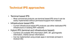
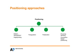
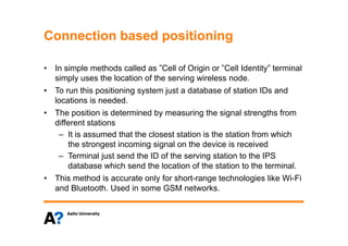
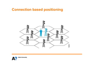
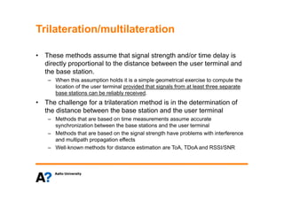
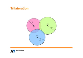
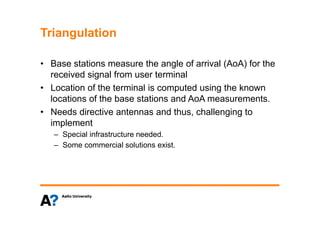
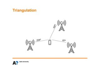
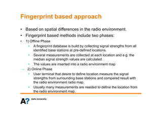
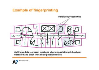
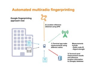
Indoor Positioning Solutions (IPS): Someg ( )
background
J. Hämäläinen, August 2013
D t t f C i ti d N t kiDepartment of Communications and Networking
Business backgroundBusiness background
• The indoor location market is growing rapidly
At l t 130 i i l di bi l ki– At least 130 companies – including some big players - are working
on indoor maps, tracking and navigation technologies and services.
– Indoor location market is expected to grow fast and potentialp g p
benefits are seen in every level (consumer, service provider,
operator and supplier).
– There are individual players like Google and also group of players– There are individual players like Google and also group of players
like Nokia lead In-location alliance
http://www.in-location-alliance.com/
Some IPS use scenariosSome IPS use scenarios
• Navigation• Navigation
– Finding places in large office buildings, university buildings,malls, museums,
hospitals
Emergency situations: navigation of rescue personality and localization of– Emergency situations: navigation of rescue personality and localization of
people
• People and property tracking – patients, kids, visitors, travellers
– Example: Baggage tracking in airports
– Logistic – cargo and container tracking in warehouses, harbours, airports etc.
– Device (Factories, Offices & Hospitals) and items tracking (keys, wallets, bag,
l )laptops etc.)
• User applications
– Social applications: Finding peoplepp g p p
– Shopping, indoor parking assistance
• Advertising
Market expectations: Example onMarket expectations: Example on
Advertising
• Example: Local business
is spending on
advertising 50$ billion peradvertising 50$ billion per
year.
• ABI Research proposes
that by 2017 up to 4$
billion would be spent on
indoor positioning basedp g
advertising.
• This is just one service
example but indicates theexample but indicates the
expected potential of IP
technology. Indoor Location Revenues, Split by Infrastructure,
Analytics, and Advertising. World Market, Forecast:
2010 to 2017 (ABI Research 6/2012)
Technical IPS approachesTechnical IPS approaches
• Terminal based IPS:
– Most commercial products use terminal based IPS since it can be
easily implemented without permission/support from networkeasily implemented without permission/support from network.
• Infrastructure based IPS:
– Current infrastructure based IPS products use either dedicated IPSp
infrastructure or existing WiFi networks
• Hybrid IPS (terminal and infrastructure based):
Combine all available IPS information (WiFi BT geomagnetic– Combine all available IPS information (WiFi, BT, geomagnetic
information, intertia sensor information)
– Can be implemented using simple apps in terminals (at least in
A d id OS)Android OS)
Some baseline positioning methodsSome baseline positioning methods
Positioning approachesPositioning approaches
Positioning
Pattern
T i l ti T il t ti
ProximityPattern
Recognition/
fingerprinting
Triangulation Trilateration
Proximity
Sensing
Connection
based
positioningpositioning
Connection based positioningConnection based positioning
• In simple methods called as ”Cell of Origin or ”Cell Identity” terminal• In simple methods called as Cell of Origin or Cell Identity terminal
simply uses the location of the serving wireless node.
• To run this positioning system just a database of station IDs and
locations is needed.
• The position is determined by measuring the signal strengths from
different stationsdifferent stations
– It is assumed that the closest station is the station from which
the strongest incoming signal on the device is received
– Terminal just send the ID of the serving station to the IPS
database which send the location of the station to the terminal.
• This method is accurate only for short-range technologies like Wi-Fi• This method is accurate only for short-range technologies like Wi-Fi
and Bluetooth. Used in some GSM networks.
Connection based positioningConnection based positioning
Trilateration/multilaterationTrilateration/multilateration
• These methods assume that signal strength and/or time delay is• These methods assume that signal strength and/or time delay is
directly proportional to the distance between the user terminal and
the base station.
– When this assumption holds it is a simple geometrical exercise to compute the
location of the user terminal provided that signals from at least three separate
base stations can be reliably received.
Th h ll f t il t ti th d i i th d t i ti f• The challenge for a trilateration method is in the determination of
the distance between the base station and the user terminal
– Methods that are based on time measurements assume accurate
synchronization between the base stations and the user terminal
– Methods that are based on the signal strength have problems with interference
and multipath propagation effects
– Well‐known methods for distance estimation are ToA, TDoA and RSSI/SNR
TrilaterationTrilateration
TriangulationTriangulation
B t ti th l f i l (A A) f th• Base stations measure the angle of arrival (AoA) for the
received signal from user terminal
• Location of the terminal is computed using the known• Location of the terminal is computed using the known
locations of the base stations and AoA measurements.
• Needs directive antennas and thus challenging toNeeds directive antennas and thus, challenging to
implement
– Special infrastructure needed.
– Some commercial solutions exist.
TriangulationTriangulation
Fingerprint based approachFingerprint based approach
• Based on spatial differences in the radio environment.p
• Fingerprint based methods include two phases:
• 1) Offline Phase
• A fingerprint database is build by collecting signal strengths from all
identified base stations at pre-defined locations.
• Several measurements are collected at each location and e.g. theg
median signal strength values are calculated.
• The values are inserted into a radio environment map
– 2) Online Phase2) Online Phase
• User terminal that desire to define location measure the signal
strengths from surrounding base stations and compared result with
the radio environment radio mapthe radio environment radio map.
• Usually many measurements are needed to define the location from
the radio environment map.
Example of fingerprintingExample of fingerprinting
Transition probabilities
Light blue dots represent locations where signal strength has been
measured and black lines show possible routes
GoogleGoogle
The big player: GoogleThe big player: Google
• Due to Google business approach the user reach in
general is of great importance.
• Google provides IPS map database and location functions
through Android
http://maps.google.com/help/maps/indoormaps/
• Did you know that Google uses your Android to collect
location based information?location based information?
Teaser: How google aggregatesTeaser: How google aggregates
radio data for positioning?
Automated fingerprintingAutomated fingerprinting
• Android Location Services check periodically user• Android Location Services check periodically user
location using GPS, 3GPP Cell-ID, and Wi-Fi to locate
your device
• When location is defined, user’s Android phone will send
back Wi-Fi access points' Service set identifier (SSID)
and Media Access Control (MAC) dataand Media Access Control (MAC) data
• As a result Google can aggregate radio fingerprinting
information taking advantage of users that employinformation taking advantage of users that employ
Android based location services
• Not only Google does this. It's common practice for
location database vendors.
Automated multiradio fingerprintingAutomated multiradio fingerprinting
Google fingerprinting
2) Location reference
Google fingerprinting
approach now
obtained using GPS
WiFi
pRBS
1) Terminal app make
measurements using
different radios
Measurements
include
- Radio node ID
Si l t thWiFi
3) Terminal send
measurement results
- Signal strength
mRBS
and reference
location information
to (Google) database
LimitationsLimitations
• The bottleneck in the Google approach is that accurate user• The bottleneck in the Google approach is that accurate user
location is needed before measured radio fingerprinting information
is useful
Usually best reference location is obtained through GPS• Usually best reference location is obtained through GPS
 automated indoor fingerprinting is difficult due to lack of GPS
 either manual fingerprinting or other location reference information is
needed indoorsneeded indoors
 manual fingerprinting is not possible without access to indoor premises
(then, of course, access to indoor maps can be limited)
 some development attempts have been done to use inertia sensors to some development attempts have been done to use inertia sensors to
provide reference location: location known when entering the building
and inertia sensors used to update location. Accuracy of this method
decreases with distance that user moves
> Google has been focusing on IPS for public venues – this far
Q ti ?Questions?

Indoor Positioning Systems

  • 1.
    Indoor Positioning Solutions(IPS): Someg ( ) background J. Hämäläinen, August 2013 D t t f C i ti d N t kiDepartment of Communications and Networking
  • 2.
    Business backgroundBusiness background •The indoor location market is growing rapidly At l t 130 i i l di bi l ki– At least 130 companies – including some big players - are working on indoor maps, tracking and navigation technologies and services. – Indoor location market is expected to grow fast and potentialp g p benefits are seen in every level (consumer, service provider, operator and supplier). – There are individual players like Google and also group of players– There are individual players like Google and also group of players like Nokia lead In-location alliance http://www.in-location-alliance.com/
  • 3.
    Some IPS usescenariosSome IPS use scenarios • Navigation• Navigation – Finding places in large office buildings, university buildings,malls, museums, hospitals Emergency situations: navigation of rescue personality and localization of– Emergency situations: navigation of rescue personality and localization of people • People and property tracking – patients, kids, visitors, travellers – Example: Baggage tracking in airports – Logistic – cargo and container tracking in warehouses, harbours, airports etc. – Device (Factories, Offices & Hospitals) and items tracking (keys, wallets, bag, l )laptops etc.) • User applications – Social applications: Finding peoplepp g p p – Shopping, indoor parking assistance • Advertising
  • 4.
    Market expectations: ExampleonMarket expectations: Example on Advertising • Example: Local business is spending on advertising 50$ billion peradvertising 50$ billion per year. • ABI Research proposes that by 2017 up to 4$ billion would be spent on indoor positioning basedp g advertising. • This is just one service example but indicates theexample but indicates the expected potential of IP technology. Indoor Location Revenues, Split by Infrastructure, Analytics, and Advertising. World Market, Forecast: 2010 to 2017 (ABI Research 6/2012)
  • 5.
    Technical IPS approachesTechnicalIPS approaches • Terminal based IPS: – Most commercial products use terminal based IPS since it can be easily implemented without permission/support from networkeasily implemented without permission/support from network. • Infrastructure based IPS: – Current infrastructure based IPS products use either dedicated IPSp infrastructure or existing WiFi networks • Hybrid IPS (terminal and infrastructure based): Combine all available IPS information (WiFi BT geomagnetic– Combine all available IPS information (WiFi, BT, geomagnetic information, intertia sensor information) – Can be implemented using simple apps in terminals (at least in A d id OS)Android OS)
  • 6.
    Some baseline positioningmethodsSome baseline positioning methods
  • 7.
    Positioning approachesPositioning approaches Positioning Pattern Ti l ti T il t ti ProximityPattern Recognition/ fingerprinting Triangulation Trilateration Proximity Sensing Connection based positioningpositioning
  • 8.
    Connection based positioningConnectionbased positioning • In simple methods called as ”Cell of Origin or ”Cell Identity” terminal• In simple methods called as Cell of Origin or Cell Identity terminal simply uses the location of the serving wireless node. • To run this positioning system just a database of station IDs and locations is needed. • The position is determined by measuring the signal strengths from different stationsdifferent stations – It is assumed that the closest station is the station from which the strongest incoming signal on the device is received – Terminal just send the ID of the serving station to the IPS database which send the location of the station to the terminal. • This method is accurate only for short-range technologies like Wi-Fi• This method is accurate only for short-range technologies like Wi-Fi and Bluetooth. Used in some GSM networks.
  • 9.
  • 10.
    Trilateration/multilaterationTrilateration/multilateration • These methodsassume that signal strength and/or time delay is• These methods assume that signal strength and/or time delay is directly proportional to the distance between the user terminal and the base station. – When this assumption holds it is a simple geometrical exercise to compute the location of the user terminal provided that signals from at least three separate base stations can be reliably received. Th h ll f t il t ti th d i i th d t i ti f• The challenge for a trilateration method is in the determination of the distance between the base station and the user terminal – Methods that are based on time measurements assume accurate synchronization between the base stations and the user terminal – Methods that are based on the signal strength have problems with interference and multipath propagation effects – Well‐known methods for distance estimation are ToA, TDoA and RSSI/SNR
  • 11.
  • 12.
    TriangulationTriangulation B t tith l f i l (A A) f th• Base stations measure the angle of arrival (AoA) for the received signal from user terminal • Location of the terminal is computed using the known• Location of the terminal is computed using the known locations of the base stations and AoA measurements. • Needs directive antennas and thus challenging toNeeds directive antennas and thus, challenging to implement – Special infrastructure needed. – Some commercial solutions exist.
  • 13.
  • 14.
    Fingerprint based approachFingerprintbased approach • Based on spatial differences in the radio environment.p • Fingerprint based methods include two phases: • 1) Offline Phase • A fingerprint database is build by collecting signal strengths from all identified base stations at pre-defined locations. • Several measurements are collected at each location and e.g. theg median signal strength values are calculated. • The values are inserted into a radio environment map – 2) Online Phase2) Online Phase • User terminal that desire to define location measure the signal strengths from surrounding base stations and compared result with the radio environment radio mapthe radio environment radio map. • Usually many measurements are needed to define the location from the radio environment map.
  • 15.
    Example of fingerprintingExampleof fingerprinting Transition probabilities Light blue dots represent locations where signal strength has been measured and black lines show possible routes
  • 16.
  • 17.
    The big player:GoogleThe big player: Google • Due to Google business approach the user reach in general is of great importance. • Google provides IPS map database and location functions through Android http://maps.google.com/help/maps/indoormaps/ • Did you know that Google uses your Android to collect location based information?location based information?
  • 18.
    Teaser: How googleaggregatesTeaser: How google aggregates radio data for positioning?
  • 19.
    Automated fingerprintingAutomated fingerprinting •Android Location Services check periodically user• Android Location Services check periodically user location using GPS, 3GPP Cell-ID, and Wi-Fi to locate your device • When location is defined, user’s Android phone will send back Wi-Fi access points' Service set identifier (SSID) and Media Access Control (MAC) dataand Media Access Control (MAC) data • As a result Google can aggregate radio fingerprinting information taking advantage of users that employinformation taking advantage of users that employ Android based location services • Not only Google does this. It's common practice for location database vendors.
  • 20.
    Automated multiradio fingerprintingAutomatedmultiradio fingerprinting Google fingerprinting 2) Location reference Google fingerprinting approach now obtained using GPS WiFi pRBS 1) Terminal app make measurements using different radios Measurements include - Radio node ID Si l t thWiFi 3) Terminal send measurement results - Signal strength mRBS and reference location information to (Google) database
  • 21.
    LimitationsLimitations • The bottleneckin the Google approach is that accurate user• The bottleneck in the Google approach is that accurate user location is needed before measured radio fingerprinting information is useful Usually best reference location is obtained through GPS• Usually best reference location is obtained through GPS  automated indoor fingerprinting is difficult due to lack of GPS  either manual fingerprinting or other location reference information is needed indoorsneeded indoors  manual fingerprinting is not possible without access to indoor premises (then, of course, access to indoor maps can be limited)  some development attempts have been done to use inertia sensors to some development attempts have been done to use inertia sensors to provide reference location: location known when entering the building and inertia sensors used to update location. Accuracy of this method decreases with distance that user moves > Google has been focusing on IPS for public venues – this far
  • 22.