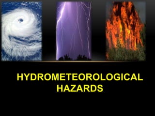
This document discusses hydrometeorological hazards such as tropical cyclones, floods, and thunderstorms. It defines hydrometeorology as the study of the atmospheric and terrestrial phases of the hydrological cycle. Various tools are used to forecast and monitor these hazards, including weather satellites, Doppler radar, and automated rain gauges. The document also provides appropriate measures to take before, during, and after hydrometeorological events.
The Philippines is prone to geological events such as earthquakes, volcanic eruptions, and landslides. These natural events bring about different hazards that may cause damage to infrastructures and endanger human lives.
The Philippines is prone to geological events such as earthquakes, volcanic eruptions, and landslides. These natural events bring about different hazards that may cause damage to infrastructures and endanger human lives.
This is a powerpoint presentation that is about one of the Senior High School Core Subject: Earth and Life Science. It is composed of the theories that explains the Earth and its Subsystems (The Four Spheres).
grade 11 chapter 4 module Earth Science: Water ResourcesRinaVeronicaFabian
a lesson explaining different water resources, hydrologic cycle, aquifers, wetland, surface water, glaciers, ground water, layers of the ocean and others.
Reference:
Luna, E.M. (2017). Hydrometeorological Hazards and Disasters. Protecting Lives, Saving Communities: Disaster Preparedness and Risk Reduction in Philippine Setting for Senior High School, pp. 90-103. Quezon City: C&E Publishing, Inc.
TEMPERATURE
COMPOSITION OF THE ATMOSPHERE
Layers of the ATMOSPHERE
WEATHER and CLIMATE
LATITUDINAL ZONES
ELEMENTS & CONTROLS OF WEATHER & CLIMATE
WARM MAJOR CURRENTS OF THE WORLD
Land Breeze & Sea Breeze
HYDROMETEOROLOGICAL HAZARDs and other related topics.pptxRaquelLansangan
Hydrometeorological hazards are natural events or phenomena that arise from the interaction of the Earth's atmosphere and water cycle, resulting in potentially destructive or harmful impacts on human societies and the environment. These hazards encompass a wide range of phenomena, from relatively localized events such as floods and landslides to large-scale events like hurricanes and droughts. Here's a detailed description of some common hydrometeorological hazards:
1. **Floods**: Floods occur when there is an overflow of water onto land that is normally dry. This can happen due to heavy rainfall, rapid snowmelt, storm surges, or the breaching of dams or levees. Floods can cause extensive damage to infrastructure, agriculture, and homes, as well as loss of life.
2. **Hurricanes and Typhoons**: These are powerful tropical cyclones characterized by strong winds, heavy rainfall, and storm surges. Hurricanes form over the Atlantic Ocean and eastern Pacific Ocean, while typhoons occur over the western Pacific Ocean. These storms can cause widespread destruction, including damage from high winds, flooding, and coastal erosion.
3. **Droughts**: Droughts are prolonged periods of abnormally low precipitation, leading to water shortages and environmental stress. Droughts can have significant impacts on agriculture, water supplies, and ecosystems, affecting both rural and urban communities.
4. **Tornadoes**: Tornadoes are violently rotating columns of air that extend from thunderstorms to the ground. They are often associated with severe thunderstorms and can cause extensive damage to buildings, infrastructure, and vegetation in their path.
5. **Landslides**: Landslides occur when slopes of hills or mountains become unstable and collapse, often triggered by heavy rainfall or earthquakes. Landslides can block roads, destroy buildings, and pose serious risks to human life in affected areas.
6. **Blizzards**: Blizzards are severe winter storms characterized by heavy snowfall, strong winds, and low visibility. They can cause transportation disruptions, power outages, and hypothermia, particularly in regions unaccustomed to such extreme weather conditions.
7. **Heatwaves**: Heatwaves are prolonged periods of excessively hot weather, often accompanied by high humidity. Heatwaves can lead to heat-related illnesses and deaths, particularly among vulnerable populations such as the elderly, infants, and those with pre-existing health conditions.
These hydrometeorological hazards pose significant challenges for disaster preparedness, response, and recovery efforts. Effective mitigation measures, including early warning systems, land-use planning, and infrastructure development, are crucial for reducing the impacts of these hazards on communities and promoting resilience in the face of natural disasters.
Hydrometeorological hazard is a process or phenomenon of atmospheric, hydrological or oceanographic nature that may cause loss of life, injury or other health impacts, property damage, loss of livelihoods and services, social and economic disruption, or environmental damage.
Learning Competencies:
-explain how typhoons develop;
- infer why the Philippines is prone to typhoons;
-explain how landmasses and bodies of water affect typhoons;
Upon the completion of this chapter, you will be able to:
Distinguish between weather and climate,
Explain the place to place distribution of temperature and rainfall in Ethiopia,
explain the time to time patterns of temperature and rainfall in Ethiopia,
Analyze climate and its implications on biophysical and socioeconomic aspects,
identify the causes, consequences and response mechanisms of climate change.
5.1 The concept of weather and climate
Both weather and climate are concepts about atmospheric conditions. The basic difference on them is duration and areal coverage.
Weather is atmospheric condition observed in a very specific area with a short term fluctuation, while
Climate is a prolonged(30-35years) atmospheric condition observed in a relatively wider geographic area.
Weather condition likely changed hour to hour, in a daily base or weakly but climate is relatively permanent.
Elements of Weather and Climate
Elements(components) of weather and climate are the following variables
Atmospheric temperature (how cold or hot is the atmosphere)
Precipitation (any kind of moisture falling from the atmosphere to the ground, mostly rainfall)
Air pressure (the weight exerted by the air)
Humidity (the level or proportion of water vapor within the atmosphere)
Sunshine (the duration and intensity of solar heat as well as light)
Wind (horizontal motion of air)
Professional air quality monitoring systems provide immediate, on-site data for analysis, compliance, and decision-making.
Monitor common gases, weather parameters, particulates.
Seminar of U.V. Spectroscopy by SAMIR PANDASAMIR PANDA
Spectroscopy is a branch of science dealing the study of interaction of electromagnetic radiation with matter.
Ultraviolet-visible spectroscopy refers to absorption spectroscopy or reflect spectroscopy in the UV-VIS spectral region.
Ultraviolet-visible spectroscopy is an analytical method that can measure the amount of light received by the analyte.
Observation of Io’s Resurfacing via Plume Deposition Using Ground-based Adapt...Sérgio Sacani
Since volcanic activity was first discovered on Io from Voyager images in 1979, changes
on Io’s surface have been monitored from both spacecraft and ground-based telescopes.
Here, we present the highest spatial resolution images of Io ever obtained from a groundbased telescope. These images, acquired by the SHARK-VIS instrument on the Large
Binocular Telescope, show evidence of a major resurfacing event on Io’s trailing hemisphere. When compared to the most recent spacecraft images, the SHARK-VIS images
show that a plume deposit from a powerful eruption at Pillan Patera has covered part
of the long-lived Pele plume deposit. Although this type of resurfacing event may be common on Io, few have been detected due to the rarity of spacecraft visits and the previously low spatial resolution available from Earth-based telescopes. The SHARK-VIS instrument ushers in a new era of high resolution imaging of Io’s surface using adaptive
optics at visible wavelengths.
Richard's aventures in two entangled wonderlandsRichard Gill
Since the loophole-free Bell experiments of 2020 and the Nobel prizes in physics of 2022, critics of Bell's work have retreated to the fortress of super-determinism. Now, super-determinism is a derogatory word - it just means "determinism". Palmer, Hance and Hossenfelder argue that quantum mechanics and determinism are not incompatible, using a sophisticated mathematical construction based on a subtle thinning of allowed states and measurements in quantum mechanics, such that what is left appears to make Bell's argument fail, without altering the empirical predictions of quantum mechanics. I think however that it is a smoke screen, and the slogan "lost in math" comes to my mind. I will discuss some other recent disproofs of Bell's theorem using the language of causality based on causal graphs. Causal thinking is also central to law and justice. I will mention surprising connections to my work on serial killer nurse cases, in particular the Dutch case of Lucia de Berk and the current UK case of Lucy Letby.
A brief information about the SCOP protein database used in bioinformatics.
The Structural Classification of Proteins (SCOP) database is a comprehensive and authoritative resource for the structural and evolutionary relationships of proteins. It provides a detailed and curated classification of protein structures, grouping them into families, superfamilies, and folds based on their structural and sequence similarities.
2. • HYDRO- Water
• METEOROLOGY- Study of
atmosphere that focuses of
weather forecasting
3. HYDROMETEOROLOGY
• is the study of the atmospheric
and terrestrial phases of the
hydrological cycle with emphasis
on the interrelationship between
them.
14. Every year, an average of 19
tropical cyclones enter the
Philippines Area of Responsibility
(PAR), and about half (9-10) make
landfall in the Philippines.
15. THE WEATHER RADAR
• RADAR is an acronym which stands for Radio
Detection and Ranging.
• A Radar sends out electromagnetic waves to
the atmosphere that is then reflected by
hydrometeors (e.g. rain, clouds) present in the
sky.
21. FLOOD
• Presence of excessive water on a
supposed dry land.
• It can be caused by continues heavy
rain or poor drainage.
• Usually in low lying area
22.
23. FLOOD CAN LEAD TO A MORE
SERIOUS PROBLEM SUCH AS:
• Disruption of commercial and industrial
operations
• Stand-still traffic
• Displacement of affected families
• Damaged properties
• Waterborne diseases
24.
25. FLASH FLOOD
• A rapid flow of water on saturated soil or
dry soil that has poor absorption
• Caused by extensive rainfall
• Maybe induced by man-made structures
such as dam
26. STORM SURGE
• Abnormal rise in coastal waters due to a
massive force from the sea or from the
air above the sea.
• Caused by strong typhoon or sea quake
• Can instantly flood coastal areas
27. TORNADO
• Rapid rotating column of air that is in
contact with the air and land
• Violent
• It can pick up objects from the ground
• 12-24 tornadoes a year in the
Philippines
• Bulacan and Nueva Ecija
29. EL NINO
• Refers to the large scale warming of the
ocean and atmosphere across central
and east-central Equitorial Pacific
• Begins with the heating up of the Pacific
Ocean near the equator
30.
31. LA NINA
• Begins in the eastern part of the pacific
ocean
• Similar to the location of el nino
• Sea temperatures become lower by 3-5
degrees
32.
33. TOOLS USED IN WEATHER
FORECASTING AND
MONITORING
HYDROMETEOROLOGICAL
HAZARDS
34. DOPPLER RADAR
• Used to measure important weather
parameters such as:
• Amount of rainfall
• Direction
• Speed
• Intensity of winds
35.
36. AUTOMATED RAIN GAUGE
• Usually installed in telecommunication
cell sites to observe and locate areas
with excessive amount of rainfall
• Detects possible flooding and flash
floods
37.
38. SIGNS OF IMPENDING HAZARDS
• Rumbling sounds
• Color, form and size of clouds- clouds
are good indicator of weather
disturbance
• Wind intensity
39. WEATHER OR SOUNDING BALOONS
• Measuring instruments are attached
below the balloon and then released
into the atmosphere to measure and
gather different atmospheric data such
as temperature, pressure, humidity and
wind speed.
• The maximum height the balloon can
reach is about 40 km.
40.
41. DRONES
• Similar purpose as the weather balloons
• They are normally sent to dangerous
areas such as the eye of typhoons or at
low altitudes to measure weather data
close to the surface.
42.
43. WEATHER SATELLITES
• It gathers more accurate data to predict or
forecast weather conditions.
• It use infrared sensors and other scanning
equipment to send back data to the surface.
• Monitors atmospheric changes, typhoon or
hurricane patterns and even glacial movements
44.
45. POLAR ORBITING SATELLITES
• Measure weather changes in a low altitude
polar orbit.
• Covers distance of up to 1000 Km above
ground and almost encircle the world to
gather data.
• National Oceanic and Atmospheric
Administration (NOAA) of US, has 2 polar
satellites names TIROS-N
46.
47. GEOSTATIONARY OPERATIONAL
ENVIRONMENTAL SATELLITES
(GOES)
• Used by NOAA to provide constant data for
continuous monitoring
• Sends data to watch for developing
weather anomalies such as typhoons
• They are placed 35,000 km above Earth
and provide a full disk view of the planet
• GOES 13 and GOES 15
48.
49. WEATHER STATIONS
• They are areas or infrastructures where
sets or a collection of different weather
instruments are installed to gather different
atmospheric data.
53. BEFORE ANY HYDROMETEOROLOGICAL
• Store enough food
• Have a flashlight, spare batteries, candles
and matches
• Meet all members of the family
• Reinforce roofs, windows and structural
support of house foundation
• Transfer appliances to higher ground
• Clear waterway such as canals
54. DURING ANY HYDROMETEOROLOGICAL
HAZARD
• If there is no advice to evacuate, stay
indoors
• Listen to weather updates
• If you see any rising in water, unplug any
electrical equipment
• Move to safer ground if advised by the
local authorities
• Bring basic necessities
• Do not go near windows
55. AFTER ANY HYDROMETEOROLOGICAL
HAZARD
• Wait for any announcements
• Report fallen powerlines or cracked
road
• Check your house for damage
• Watch out for live wires
• Boil water before drinking