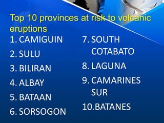
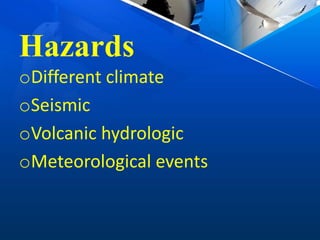
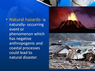
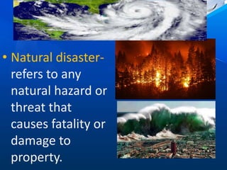
This document discusses various natural hazards in the Philippines caused by geological, hydro-meteorological and coastal processes. It provides details on seismic, volcanic and landslide events, as well as tropical cyclones, flooding and coastal erosion. Specific data is given on the provinces most at risk from earthquakes, landslides, volcanic eruptions, tsunamis and other hazards based on historical patterns and vulnerability factors. Mitigation strategies used by government agencies to monitor and warn of these risks are also summarized.
Natural Hazards: Earthquake and Volcanic Hazards + Mitigation and AdaptationKarl Ruelan
Created by: Karl Ruelan; Philippines (c) David G.
Educational Purposes Only
For Science - 11 Presentation; 8/30/16
About Natural Hazards
Specifically: Earthquake and Volcanic Hazards
It also includes: Mitigation and Adaptation to this hazards.
Powerpoint
What is Earthquake?
The minimal to rapid shaking of the ground due to the movement of rocks along fractures known as faults.
Earthquake Hazards
Surface Rupture & Physical Damage
Liquefaction
Fires
Tsunami
Landslide
Volcanic Hazards
Pyroclastic Flows and Materials
People unable to run
Bury people and agriculture
Mudflow or LAHAR
Poisonous gases
Tsunami
Volcanic Eruption
Two Types; based on magma comp.
Explosive Eruption
Non-Explosive Eruption
HAZARD MAPS
One of the government’s response to mitigate and adapt to the hazards.
Developed to indicate the places where most of the natural disasters usually occur and will most likely occur.
by the shaking itself or by the ground beneath them settling to a different level than it was before the earthquake (subsidence) or (uplift).
Subsidence is the motion of a surface (usually, the Earth's surface) as it shifts downward relative to a datum such as sea-level.
A fault is a fracture or zone of fractures between two blocks of rock. Faults allow the blocks to move relative to each other.
Philippines experience a lot of Earthquakes because it is located in the Circum-Pacific Belt, situated in the Pacific Ring of Fire
Pacific Ring of Fire is term used for VOLCANOES only.
The Philippines is prone to geological events such as earthquakes, volcanic eruptions, and landslides. These natural events bring about different hazards that may cause damage to infrastructures and endanger human lives.
Typhoon Rammasun (Cat 3) Headed Towards Manila. This tropical storm is predicted to be the first direct hit on the capital in four years. Rammasun is the strongest storm to threaten the country since Haiyan, a Cat-5 "super typhoon," that wiped out nearly everything in its path when it crossed over the central Philippines in November, 2013, just eight months ago. The major lesson from last Haiyan: ANTICIPATORY ACTIONS ARE THE KEY TO PREPAREDNESS. People who endured haiyan should know 1) what to expect (e.G., high-velocity winds, rain, flash floods, landslides, and storm surge), 2) where and when it will happen, and 3) what they should (and should not) do to prepare will survive. Presentation courtesy of Dr. Walter Hays, Global Alliance for Disaster Reduction
In light of Typhoon Haiyan, the Yale-Tulane ESF #8 Planning and Response Program has produced a special report. The Yale-Tulane ESF #8 Program is a multi-disciplinary, multi-center, graduate-level, program designed to produce ESF #8 planners and responders with standardized skill sets that are consistent with evolving public policy, technologies, and best practices. The group that produced this summary and analysis of the current situation are graduate students from Yale and Tulane Universities. It was compiled entirely from open source materials. Please feel free to forward the report to anyone who might be interested.
This subject is designed to enhance the understanding of the principles and concepts in the study of biology, particularly heredity and variation, and the diversity of living organisms, their structure, function, and evolution
LC's
Describe the principles of the ecosystem and
Categorize the different biotic and environmental resistance e.g., diseases, availability of food, and predators) that affect population explosion
Earliest Galaxies in the JADES Origins Field: Luminosity Function and Cosmic ...Sérgio Sacani
We characterize the earliest galaxy population in the JADES Origins Field (JOF), the deepest
imaging field observed with JWST. We make use of the ancillary Hubble optical images (5 filters
spanning 0.4−0.9µm) and novel JWST images with 14 filters spanning 0.8−5µm, including 7 mediumband filters, and reaching total exposure times of up to 46 hours per filter. We combine all our data
at > 2.3µm to construct an ultradeep image, reaching as deep as ≈ 31.4 AB mag in the stack and
30.3-31.0 AB mag (5σ, r = 0.1” circular aperture) in individual filters. We measure photometric
redshifts and use robust selection criteria to identify a sample of eight galaxy candidates at redshifts
z = 11.5 − 15. These objects show compact half-light radii of R1/2 ∼ 50 − 200pc, stellar masses of
M⋆ ∼ 107−108M⊙, and star-formation rates of SFR ∼ 0.1−1 M⊙ yr−1
. Our search finds no candidates
at 15 < z < 20, placing upper limits at these redshifts. We develop a forward modeling approach to
infer the properties of the evolving luminosity function without binning in redshift or luminosity that
marginalizes over the photometric redshift uncertainty of our candidate galaxies and incorporates the
impact of non-detections. We find a z = 12 luminosity function in good agreement with prior results,
and that the luminosity function normalization and UV luminosity density decline by a factor of ∼ 2.5
from z = 12 to z = 14. We discuss the possible implications of our results in the context of theoretical
models for evolution of the dark matter halo mass function.
Multi-source connectivity as the driver of solar wind variability in the heli...Sérgio Sacani
The ambient solar wind that flls the heliosphere originates from multiple
sources in the solar corona and is highly structured. It is often described
as high-speed, relatively homogeneous, plasma streams from coronal
holes and slow-speed, highly variable, streams whose source regions are
under debate. A key goal of ESA/NASA’s Solar Orbiter mission is to identify
solar wind sources and understand what drives the complexity seen in the
heliosphere. By combining magnetic feld modelling and spectroscopic
techniques with high-resolution observations and measurements, we show
that the solar wind variability detected in situ by Solar Orbiter in March
2022 is driven by spatio-temporal changes in the magnetic connectivity to
multiple sources in the solar atmosphere. The magnetic feld footpoints
connected to the spacecraft moved from the boundaries of a coronal hole
to one active region (12961) and then across to another region (12957). This
is refected in the in situ measurements, which show the transition from fast
to highly Alfvénic then to slow solar wind that is disrupted by the arrival of
a coronal mass ejection. Our results describe solar wind variability at 0.5 au
but are applicable to near-Earth observatories.
Seminar of U.V. Spectroscopy by SAMIR PANDASAMIR PANDA
Spectroscopy is a branch of science dealing the study of interaction of electromagnetic radiation with matter.
Ultraviolet-visible spectroscopy refers to absorption spectroscopy or reflect spectroscopy in the UV-VIS spectral region.
Ultraviolet-visible spectroscopy is an analytical method that can measure the amount of light received by the analyte.
The increased availability of biomedical data, particularly in the public domain, offers the opportunity to better understand human health and to develop effective therapeutics for a wide range of unmet medical needs. However, data scientists remain stymied by the fact that data remain hard to find and to productively reuse because data and their metadata i) are wholly inaccessible, ii) are in non-standard or incompatible representations, iii) do not conform to community standards, and iv) have unclear or highly restricted terms and conditions that preclude legitimate reuse. These limitations require a rethink on data can be made machine and AI-ready - the key motivation behind the FAIR Guiding Principles. Concurrently, while recent efforts have explored the use of deep learning to fuse disparate data into predictive models for a wide range of biomedical applications, these models often fail even when the correct answer is already known, and fail to explain individual predictions in terms that data scientists can appreciate. These limitations suggest that new methods to produce practical artificial intelligence are still needed.
In this talk, I will discuss our work in (1) building an integrative knowledge infrastructure to prepare FAIR and "AI-ready" data and services along with (2) neurosymbolic AI methods to improve the quality of predictions and to generate plausible explanations. Attention is given to standards, platforms, and methods to wrangle knowledge into simple, but effective semantic and latent representations, and to make these available into standards-compliant and discoverable interfaces that can be used in model building, validation, and explanation. Our work, and those of others in the field, creates a baseline for building trustworthy and easy to deploy AI models in biomedicine.
Bio
Dr. Michel Dumontier is the Distinguished Professor of Data Science at Maastricht University, founder and executive director of the Institute of Data Science, and co-founder of the FAIR (Findable, Accessible, Interoperable and Reusable) data principles. His research explores socio-technological approaches for responsible discovery science, which includes collaborative multi-modal knowledge graphs, privacy-preserving distributed data mining, and AI methods for drug discovery and personalized medicine. His work is supported through the Dutch National Research Agenda, the Netherlands Organisation for Scientific Research, Horizon Europe, the European Open Science Cloud, the US National Institutes of Health, and a Marie-Curie Innovative Training Network. He is the editor-in-chief for the journal Data Science and is internationally recognized for his contributions in bioinformatics, biomedical informatics, and semantic technologies including ontologies and linked data.
4. • Natural hazards- is
naturally- occurring
event or
phenomenon which
has negative
anthropogenic and
coastal processes
could lead to
natural disaster.
6. • Hazard mitigation- minimization
of risk. This involves learning and
understanding how the natural
processes operate.
7.
8.
9. • PHIVOLCS- Philippine Institute of
Volcanology and Seismology, the
government agency overlooking all
seismic and volcanic activities in
the Philippines, recorded 12
destructive earthquakes since
1968.
10. Top 10 provinces that are at risk to
earthquakes
1. SURIGAO DEL
SUR
2. LA UNION
3. BENGUET
4. PANGASINAN
5. PAMPANGA
6. TARLAC
7. IFUGAO
8. DAVAO
ORIENTAL
9. NUEVA VIZCAYA
10.NUEVA ECIJA
11. • La Union and Pangasinan are
prone to Earthquake, due to
Manila trench while Surigao del
Sur and Davao Oriental are at risk
for earthquakes due to Philippine
Trench and nearby active faults.
12. LANDSLIDES
• When earthquakes
happen in humanmade
embankments and
natural slopes in
mountains areas, the
hazard and potential
devastation greatly
increases
13.
14. Top 10 provinces that are at risk to
lanslides hazards
1. IFUGAO
2. LANAO DEL SUR
3. SARANGANI
4. BENGUET
5. MOUNTAIN
PROVINCES
6. BUKIDNON
7. AURORA
8. DAVAO DEL SUR
9. DAVAO ORIENTAL
10.RIZAL
15. • Ifugao, Lanao del Sur, and Sarangani
are highly vulnerable to landslide
compared to Rizal. Despite the low
vulnerability of Benguet, its high
exposure factor or population
density have made living in the
region are more risky.
16.
17. • The Philippines lies within the Pacific
Ring of Fire. This explains the
distribution of most volcanoes in the
Philippines.
• The mount Pinatubo eruption of 1991
was well known to be the most violent
eruption the 20th century.
• There are 22 historically active volcanoes
distributed all over the Philippines.
18.
19. Top 10 provinces at risk to volcanic
eruptions
1. CAMIGUIN
2. SULU
3. BILIRAN
4. ALBAY
5. BATAAN
6. SORSOGON
7. SOUTH
COTABATO
8. LAGUNA
9. CAMARINES
SUR
10.BATANES
20. • Camiguin is at high risk because the
land area is so small that when a
volcanic eruption occur, it can affect
the whole province. Sulu ranked 2nd
because it has the most number of
active and potentially- active
volcanoes.
22. Top 10 provinces that are at risk to
tsunamis
1. SULU
2. TAWI-TAWI
3. BASILAN
4. BATANES
5. GUIMARAS
6. ROMBLON
7. SIQUIJOR
8. SURIGAO DEL
NORTE
9. CAMIGUIN
10.MASBATE
23. • Sulu and Tawi-tawi are highly vulnerable to
tsunami due to their being in between two
nearby trenches (Sulu trench and Cotabato
trench) and their dense population.
• Most areas in Basilan and Romblon are at
high at risk especially because they have
been previously affected by a tsunami.
25. Northeast Moonsoon Southwest Moonsoon
HABAGATAMIHAN
MOONSOON- is a consistent reversal of
wind pattern or a wind system generated by
large weather system.
26. • PAGASA- Philippine Atmospheric
Geophysical, and Astronomical Services- is
the government weather bureau which
monitor atmospheric occurrences within the
Philippine area of responsibility, its
internationally- recognized jurisdiction.
• Tropical cyclones or bagyo are common in the
Philippines due to its being in the typhoon
belt.
• PAGASA records an average of 20 tropical
cyclones entering the PAR annually.
27. Tropical Cyclones and Wind Speeds
TYPE SUSTAINED WIND
NEAR THE CENTER
Tropical depression 30- 60 km/h
Tropical storm 61-88 km/h
Severe tropical storm 89-117 km/h
typhoon 118-219 km/h
Super typhoon Faster than 220 km/h
28. Mitigation and Prevention
• To mitigate the effects of tropical
cyclones and flooding, PAGASA have
implemented some measures. Floods
and 3D hazard maps are made to
disseminated to areas which are
usually hit by typhoons and areas
which are prone to flooding.
29. Public Storm Warning System
Level Wind And Lead Time
1 30-60km/H ; Within 36 Hours
2 60-120km/H; Within 24 Hours
3 120-170 Km/H; Within 18 Hours
4 170-220 Km/H; Within 12 Hours
5 Faster Than 220km/H; Within 12 Hours
30. • Using PAGASA’s PSWS, the Department of
Education (DepEd) has adopted the following
guidelines with regards to class suspension:
PSWS 1- All classes in kindergarten are
suspended
PSWS 2- All classes in elementary and high
school are suspended
PSWS 3- All classes in all levels, including
college and graduate schools, are suspended
33. • Coastal hazards are caused by waves,
tides, and coastal erosion.
• There are 3 billion people are living
within 200 km near the coastlines.
• Coastal are refers to the land and sea
areas bordering the shorline.
34. Submersion and Coastal Erosion
• Waves, which are caused by wind and storms,
cause large impacts around the coastline for
the potential coastal erosion, flooding, and
damages they may bring.
• Tides, which are the result of the gravitational
attraction of the sun and moon on the oceans,
cause the frequent rise and fall of ocean
levels.
35. • The processes of wave action, wave
currents, and tidal currents wear away the
land and removes sediments near the
coastline. This effect is called coastal
erosion.
• Building seawalls which run parallel to the
sea prevents the direct impact of coastal
processes to landforms near he coast.
36. Salt Intrusion
• When saline water moves into freshwater
aquifers, which are the main source of
drinking water in coastal areas, it often
leads to contamination.
• Intrusion of saltwater happens naturally
because of the varying densities of
saltwater and freshwater.