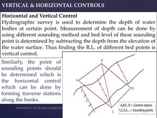
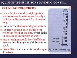
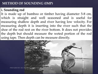
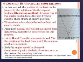
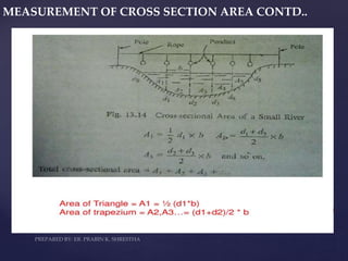
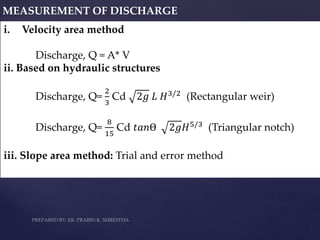
ER. PRABIN KUMAR SHRESTHA POKHARA ENGINEERING COLLEGE
CHPTER 3: HYDROGRAPHIC SURVEY
INTRODUCTION:
Hydrographic Surveying is the branch of surveying which deals
with the measurement of bodies of water such as a lake, harbor,
stream or river. Hydrographic surveys are used to define shore
line and under water features.
USES AND APPLICATION:
i. For making nautical charts (map) for navigation.
ii. For determine channel depth.
iii. For determining under water elevation.
iv. For determining discharge of flow.
v. For determination of scour depth or silting depth of the river.
vi. For determining the velocity of flow.
vii. For planning the projects like bridge, dam, reservoir, cross
drainage structures etc. related to the project on water bodies.
viii. For controlling and mitigating flood.
Output of
Hydrographic
Survey
MEASUREMENT OF FLOW VELOCITY:
MEASUREMENT OF FLOW VELOCITY CONTD..
VERTICAL & HORIZONTAL CONTROLS
Horizontal and Vertical Control
Hydrographic survey is used to determine the depth of water
bodies at certain point. Measurement of depth can be done by
using different sounding method and bed level of these sounding
point is determined by subtracting the depth from the elevation of
the water surface. Thus finding the R.L. of different bed points is
vertical control.
Similarly, the point of
sounding points should
be determined which is
the horizontal control
which can be done by
forming traverse stations
along the banks.
Points to be remember wihile selecting the control stations
i. Control stations should be intervisible
ii. For long and narrow river, traverse can be at one bank only.
iii. For long and wide river greater than one km wide traverse
can be done along the both bank and the station should be
tied up.
iv. If site is not suitable or impossible for traversing then
triangulation can be done.
EQUIPMENTS NEEDED FOR SOUNDING
EQUIPMENTS NEEDED FOR SOUNDING CONTD…
METHOD OF SOUNDING (IMP)
i. Sounding rod
It is made up of bamboo or timber having diameter 5-8 cm,
which is straight and well seasoned and is useful for
measuring shallow depth and river having low velocity. For
measuring depth it is inserting into the river such that the
shoe of the rod rest on the river bottom. It does not provides
the depth but should measure the weted portion of the rod
using tape. Then depth can be measure directly.
METHOD OF SOUNDING (IMP)
ii. Sounding cables
It is similar to sounding rod but
instead of rod cable is provided
which facilate to measure greater
depth then sounding rod. It can be
used for measuring the depth upto
10m for low velocity river or stable
river.
METHOD OF SOUNDING (IMP)
iii. Sounding machine
It is similar to sounding cable where no need of measuring the
wetted portion of cable. The released length of the cable can be
known with the help of number of revolution of drum for
releasing the cables while sounding is recorded in the machine.
Sounding machine can be used to measure depth up to 100 ft.
METHOD OF SOUNDING (IMP)
iv. Fathometer (Eco- Sounding)
Eco-sounding is used for measuring the depth of large water
bodies where current of water is very high and when depth of
water body is more than 10m.Eco- sounding consist of emitter and
receiver while measuring depth the emitter transmit the sound
wave from the surface of the water to the bed of the water and this
wave is reflected back which is received by the receiver. The time
at which the signal is set and received is automatically recorded
by the instrument. The double distance travelled by the wave and
time recorded helps to measure the velocity of sound wave in
water.
Velocity (v) =
2𝑑
𝑡−𝑜
=
2𝑑
𝑡
By knowing velocity of sund in water as 1470 m/s, the one way
distance travelled by wave can be calculated
d =
𝒗𝒕
𝟐
METHOD OF SOUNDING (IMP)
Actual depth, h = 𝑑2 − (
𝑥
2
)²
x/2
d
d
x/2
ADVANTAGES OF ECO – SOUNDING (IMP)
i. This method is more sensible than other method of sounding
ii. The speed of sounding is very high and fast.
iii. Flow current as well as bed weather condition don’t distrub
the sounding process.
iv. It provides true vertical depth.
v. It gives continuous record of the bed.
METHOD OF LOCATING SOUNDING POSITION (IMP)
The points of sounding should be located in the horizontal plane,
so that it can be plotted on the drawing sheet. The position
(horizontal control) can be located by following ways:
MEASUREMENT OF CROSS SECTION AREA
MEASUREMENT OF CROSS SECTION AREA CONTD..
MEASUREMENT OF DISCHARGE
i. Velocity area method
Discharge, Q = A* V
ii. Based on hydraulic structures
Discharge, Q=
2
3
Cd 2𝑔 𝐿 𝐻3/2 (Rectangular weir)
Discharge, Q=
8
15
Cd 𝑡𝑎𝑛Ɵ 2𝑔𝐻5/3
(Triangular notch)
iii. Slope area method: Trial and error method
Hydrographic survey.pptx

Hydrographic survey.pptx

  • 1.
    ER. PRABIN KUMARSHRESTHA POKHARA ENGINEERING COLLEGE
  • 2.
    CHPTER 3: HYDROGRAPHICSURVEY INTRODUCTION: Hydrographic Surveying is the branch of surveying which deals with the measurement of bodies of water such as a lake, harbor, stream or river. Hydrographic surveys are used to define shore line and under water features. USES AND APPLICATION: i. For making nautical charts (map) for navigation. ii. For determine channel depth. iii. For determining under water elevation. iv. For determining discharge of flow. v. For determination of scour depth or silting depth of the river. vi. For determining the velocity of flow. vii. For planning the projects like bridge, dam, reservoir, cross drainage structures etc. related to the project on water bodies. viii. For controlling and mitigating flood.
  • 3.
  • 4.
  • 5.
    MEASUREMENT OF FLOWVELOCITY CONTD..
  • 6.
    MEASUREMENT OF FLOWVELOCITY CONTD..
  • 7.
    MEASUREMENT OF FLOWVELOCITY CONTD..
  • 8.
    MEASUREMENT OF FLOWVELOCITY CONTD..
  • 9.
    MEASUREMENT OF FLOWVELOCITY CONTD..
  • 11.
    VERTICAL & HORIZONTALCONTROLS Horizontal and Vertical Control Hydrographic survey is used to determine the depth of water bodies at certain point. Measurement of depth can be done by using different sounding method and bed level of these sounding point is determined by subtracting the depth from the elevation of the water surface. Thus finding the R.L. of different bed points is vertical control. Similarly, the point of sounding points should be determined which is the horizontal control which can be done by forming traverse stations along the banks.
  • 12.
    Points to beremember wihile selecting the control stations i. Control stations should be intervisible ii. For long and narrow river, traverse can be at one bank only. iii. For long and wide river greater than one km wide traverse can be done along the both bank and the station should be tied up. iv. If site is not suitable or impossible for traversing then triangulation can be done.
  • 13.
  • 14.
    EQUIPMENTS NEEDED FORSOUNDING CONTD…
  • 15.
    EQUIPMENTS NEEDED FORSOUNDING CONTD…
  • 16.
    EQUIPMENTS NEEDED FORSOUNDING CONTD…
  • 17.
    METHOD OF SOUNDING(IMP) i. Sounding rod It is made up of bamboo or timber having diameter 5-8 cm, which is straight and well seasoned and is useful for measuring shallow depth and river having low velocity. For measuring depth it is inserting into the river such that the shoe of the rod rest on the river bottom. It does not provides the depth but should measure the weted portion of the rod using tape. Then depth can be measure directly.
  • 18.
    METHOD OF SOUNDING(IMP) ii. Sounding cables It is similar to sounding rod but instead of rod cable is provided which facilate to measure greater depth then sounding rod. It can be used for measuring the depth upto 10m for low velocity river or stable river.
  • 19.
    METHOD OF SOUNDING(IMP) iii. Sounding machine It is similar to sounding cable where no need of measuring the wetted portion of cable. The released length of the cable can be known with the help of number of revolution of drum for releasing the cables while sounding is recorded in the machine. Sounding machine can be used to measure depth up to 100 ft.
  • 20.
    METHOD OF SOUNDING(IMP) iv. Fathometer (Eco- Sounding) Eco-sounding is used for measuring the depth of large water bodies where current of water is very high and when depth of water body is more than 10m.Eco- sounding consist of emitter and receiver while measuring depth the emitter transmit the sound wave from the surface of the water to the bed of the water and this wave is reflected back which is received by the receiver. The time at which the signal is set and received is automatically recorded by the instrument. The double distance travelled by the wave and time recorded helps to measure the velocity of sound wave in water. Velocity (v) = 2𝑑 𝑡−𝑜 = 2𝑑 𝑡 By knowing velocity of sund in water as 1470 m/s, the one way distance travelled by wave can be calculated d = 𝒗𝒕 𝟐
  • 21.
    METHOD OF SOUNDING(IMP) Actual depth, h = 𝑑2 − ( 𝑥 2 )² x/2 d d x/2
  • 22.
    ADVANTAGES OF ECO– SOUNDING (IMP) i. This method is more sensible than other method of sounding ii. The speed of sounding is very high and fast. iii. Flow current as well as bed weather condition don’t distrub the sounding process. iv. It provides true vertical depth. v. It gives continuous record of the bed. METHOD OF LOCATING SOUNDING POSITION (IMP) The points of sounding should be located in the horizontal plane, so that it can be plotted on the drawing sheet. The position (horizontal control) can be located by following ways:
  • 32.
  • 33.
    MEASUREMENT OF CROSSSECTION AREA CONTD..
  • 34.
    MEASUREMENT OF CROSSSECTION AREA CONTD..
  • 35.
    MEASUREMENT OF DISCHARGE i.Velocity area method Discharge, Q = A* V ii. Based on hydraulic structures Discharge, Q= 2 3 Cd 2𝑔 𝐿 𝐻3/2 (Rectangular weir) Discharge, Q= 8 15 Cd 𝑡𝑎𝑛Ɵ 2𝑔𝐻5/3 (Triangular notch) iii. Slope area method: Trial and error method