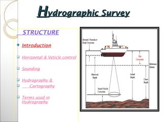
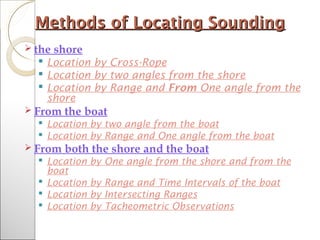
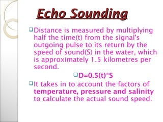
Government EngineeringGovernment Engineering
College,Palanpur.College,Palanpur.
Sub:SurveyingSub:Surveying
Guidence by: Prof. R.K.RathodGuidence by: Prof. R.K.Rathod
Topic:Hydrography :SoundingTopic:Hydrography :Sounding
InstrumentInstrument
PPreparedrepared bbyy
No. NAME Enrolment No.
1 SOLANKI TEJALBEN JAYANTILAL 150610106056
2 SONI DHRUVIBEN GIRISHBHAI 15061010657
3 THAKKAR VIPUL JAYESHBHAI 150610106058
4 THAKOR KRUNAL NARPATBHAI 150610106060
5 THAKOR RAHUL RAMSINGH 150610106061
HHydrographic Surveyydrographic Survey
STRUCTURE
 Introduction
 Horizontal & Veticle control
 Sounding
 Hydrography &
 Cartography
 Terms used in
Hydrography
HydrographyHydrography
 Branch of science that deals with the measurement of
bodies of water
 Deals with the physical features of the navigable
portion of the earth’s surface and adjoining coastal
areas.
 Sounding –measurement of depth below the water
surface
Applications of sounding:
◦ Making nautical charts for safety of
navigation
◦ Development and engineering projects
such as piers, dams and bridges
◦ Scientific and academic studies
Horizontal Control and VerticalHorizontal Control and Vertical
ControlControl
Horizontal Control
 For large areas – 2nd
or 3rd
order triangulation
For smaller areas – transit-tape traverse
For small detached areas – stadia,
graphical, plane table methods
For long narrow river – traverse on one
side
For width >1km – traverse on both sides
Vertical Control
Tide gauges are used to establish the common
datum before sounding is taken
Shoreline SurveyShoreline Survey
o Shoreline
o Syn. to Coastline
o Line of contact between the land and the body of
water
o USC&GS uses the high water line
o It consist of:
oDetermination or delineation of shorelines
oLocation of shore details and prominent
features to which soundings may be
connected
oDetermination of low and high water lines
Shoreline SurveyShoreline Survey
Methods of Locating SoundingMethods of Locating Sounding
 the shore
 Location by Cross-Rope
 Location by two angles from the shore
 Location by Range and From One angle from the
shore
 From the boat
 Location by two angle from the boat
 Location by Range and One angle from the boat
 From both the shore and the boat
 Location by One angle from the shore and from the
boat
 Location by Range and Time Intervals of the boat
 Location by Intersecting Ranges
 Location by Tacheometric Observations
Sounding LinesSounding Lines
 Systems of Sounding Lines
 Parallel straight lines –> open coasts
 Radiating lines –> small bays and islets
 Circular curves or arcs –> isolated shoal
 Spacing of Sounding Lines
 Factors: the scale of the survey, depth of water,
proximity to shore, character of submarine relief,
importance of the region
Scale Ordinary Spacing Closest Spacing
1:10,000 50-60 25-30
1:20,000 100-125 50-60
1:40,000 200-250 100-125
1:80,000 400-500 200-250
1:120,000 600-750 300-375
SoundingSounding
Instruments used in SoundingInstruments used in Sounding
The methods of determining water depth are
differentiated by the instruments used .
 Sounding Pole
 The Leadline
 Sounding Machines
 Registering sheaves
 Echo sounding Instrument or Fathometer
Echo SoundingEcho Sounding
Distance is measured by multiplying
half the time(t) from the signal's
outgoing pulse to its return by the
speed of sound(S) in the water, which
is approximately 1.5 kilometres per
second.
D=0.5(t)*S
It takes in to account the factors of
temperature, pressure and salinity
to calculate the actual sound speed.
Reduction of SoundingReduction of Sounding
The reduced sounding are the reduced
levels of the submarine surface in terms
of the adopted datum
A correction equal to the difference of
level between the actual water
level(gauge reading) and the
datum(MLW/MLLW) is applied to the
observed soundings.
Hydrographic Survey TeamHydrographic Survey Team
1. Officer-in-charge/Chief-of-party
2. Left Angleman
3. Right Angleman
4. Recorder
5. Fathometer attendant
6. Leadsman
7. Leadsman’s assistant
8. Helmsman or Coxwain
9. Engineer
10. Additional general utility personnel
Hydrography and CartographyHydrography and Cartography
 Cartography – science and art of the
production of maps and charts
 Nautical charts-> polyconic projection
 Instruments used in the preparation of
Nautical Charts
 3-arm protractor
 Hairspring divider
 Spacing divider
 Proportional divider
 Meter Bar
 Opisometer/Map measure
 Beam Compass
Nautical ChartNautical Chart
The Nautical chart or hydrographic map
should contain the following
information
Datum used
High, mean, low water lines
Soundings
Line of equal interpolated from the
soundings called depth curves
Conventional symbols
All safety devices such as lighthouse, buoys
etc.
Complete border information
The Nautical ChartThe Nautical Chart
A nautical chart is a graphic
representation of a maritime area and
adjacent coastal regions.
Datums of a Nautical Chart
Horizontal Datum
Vertical Datum
 Atlantic Ocean – Mean Low Water
 Pacific Ocean – Mean Lower Low Water
Plotting of SoundingsPlotting of Soundings
Soundings can be plotted in 3 ways
Mechanical Solution
By tracing paper
By Station Pointer
Graphical Solution
Method 1
Method 2
Analytical Solution
Other Essential in HydrographyOther Essential in Hydrography
The Sextant
An instrument used to measure the angle
between any two visible objects.
The Boat sheet/Hydrographic sheet
The Wire drag
A device used to detect obstructions such as
boulders and ledges. These obstructions
should be plotted in the Navigational charts.
Thank youThank you

Hydrography :Sounding Instrument

  • 1.
  • 2.
    Topic:Hydrography :SoundingTopic:Hydrography :Sounding InstrumentInstrument PPreparedreparedbbyy No. NAME Enrolment No. 1 SOLANKI TEJALBEN JAYANTILAL 150610106056 2 SONI DHRUVIBEN GIRISHBHAI 15061010657 3 THAKKAR VIPUL JAYESHBHAI 150610106058 4 THAKOR KRUNAL NARPATBHAI 150610106060 5 THAKOR RAHUL RAMSINGH 150610106061
  • 3.
    HHydrographic Surveyydrographic Survey STRUCTURE Introduction  Horizontal & Veticle control  Sounding  Hydrography &  Cartography  Terms used in Hydrography
  • 4.
    HydrographyHydrography  Branch ofscience that deals with the measurement of bodies of water  Deals with the physical features of the navigable portion of the earth’s surface and adjoining coastal areas.  Sounding –measurement of depth below the water surface Applications of sounding: ◦ Making nautical charts for safety of navigation ◦ Development and engineering projects such as piers, dams and bridges ◦ Scientific and academic studies
  • 5.
    Horizontal Control andVerticalHorizontal Control and Vertical ControlControl Horizontal Control  For large areas – 2nd or 3rd order triangulation For smaller areas – transit-tape traverse For small detached areas – stadia, graphical, plane table methods For long narrow river – traverse on one side For width >1km – traverse on both sides Vertical Control Tide gauges are used to establish the common datum before sounding is taken
  • 6.
    Shoreline SurveyShoreline Survey oShoreline o Syn. to Coastline o Line of contact between the land and the body of water o USC&GS uses the high water line o It consist of: oDetermination or delineation of shorelines oLocation of shore details and prominent features to which soundings may be connected oDetermination of low and high water lines
  • 7.
  • 8.
    Methods of LocatingSoundingMethods of Locating Sounding  the shore  Location by Cross-Rope  Location by two angles from the shore  Location by Range and From One angle from the shore  From the boat  Location by two angle from the boat  Location by Range and One angle from the boat  From both the shore and the boat  Location by One angle from the shore and from the boat  Location by Range and Time Intervals of the boat  Location by Intersecting Ranges  Location by Tacheometric Observations
  • 9.
    Sounding LinesSounding Lines Systems of Sounding Lines  Parallel straight lines –> open coasts  Radiating lines –> small bays and islets  Circular curves or arcs –> isolated shoal  Spacing of Sounding Lines  Factors: the scale of the survey, depth of water, proximity to shore, character of submarine relief, importance of the region Scale Ordinary Spacing Closest Spacing 1:10,000 50-60 25-30 1:20,000 100-125 50-60 1:40,000 200-250 100-125 1:80,000 400-500 200-250 1:120,000 600-750 300-375
  • 10.
  • 11.
    Instruments used inSoundingInstruments used in Sounding The methods of determining water depth are differentiated by the instruments used .  Sounding Pole  The Leadline  Sounding Machines  Registering sheaves  Echo sounding Instrument or Fathometer
  • 12.
    Echo SoundingEcho Sounding Distanceis measured by multiplying half the time(t) from the signal's outgoing pulse to its return by the speed of sound(S) in the water, which is approximately 1.5 kilometres per second. D=0.5(t)*S It takes in to account the factors of temperature, pressure and salinity to calculate the actual sound speed.
  • 13.
    Reduction of SoundingReductionof Sounding The reduced sounding are the reduced levels of the submarine surface in terms of the adopted datum A correction equal to the difference of level between the actual water level(gauge reading) and the datum(MLW/MLLW) is applied to the observed soundings.
  • 14.
    Hydrographic Survey TeamHydrographicSurvey Team 1. Officer-in-charge/Chief-of-party 2. Left Angleman 3. Right Angleman 4. Recorder 5. Fathometer attendant 6. Leadsman 7. Leadsman’s assistant 8. Helmsman or Coxwain 9. Engineer 10. Additional general utility personnel
  • 15.
    Hydrography and CartographyHydrographyand Cartography  Cartography – science and art of the production of maps and charts  Nautical charts-> polyconic projection  Instruments used in the preparation of Nautical Charts  3-arm protractor  Hairspring divider  Spacing divider  Proportional divider  Meter Bar  Opisometer/Map measure  Beam Compass
  • 16.
    Nautical ChartNautical Chart TheNautical chart or hydrographic map should contain the following information Datum used High, mean, low water lines Soundings Line of equal interpolated from the soundings called depth curves Conventional symbols All safety devices such as lighthouse, buoys etc. Complete border information
  • 17.
    The Nautical ChartTheNautical Chart A nautical chart is a graphic representation of a maritime area and adjacent coastal regions. Datums of a Nautical Chart Horizontal Datum Vertical Datum  Atlantic Ocean – Mean Low Water  Pacific Ocean – Mean Lower Low Water
  • 18.
    Plotting of SoundingsPlottingof Soundings Soundings can be plotted in 3 ways Mechanical Solution By tracing paper By Station Pointer Graphical Solution Method 1 Method 2 Analytical Solution
  • 19.
    Other Essential inHydrographyOther Essential in Hydrography The Sextant An instrument used to measure the angle between any two visible objects. The Boat sheet/Hydrographic sheet The Wire drag A device used to detect obstructions such as boulders and ledges. These obstructions should be plotted in the Navigational charts.
  • 20.