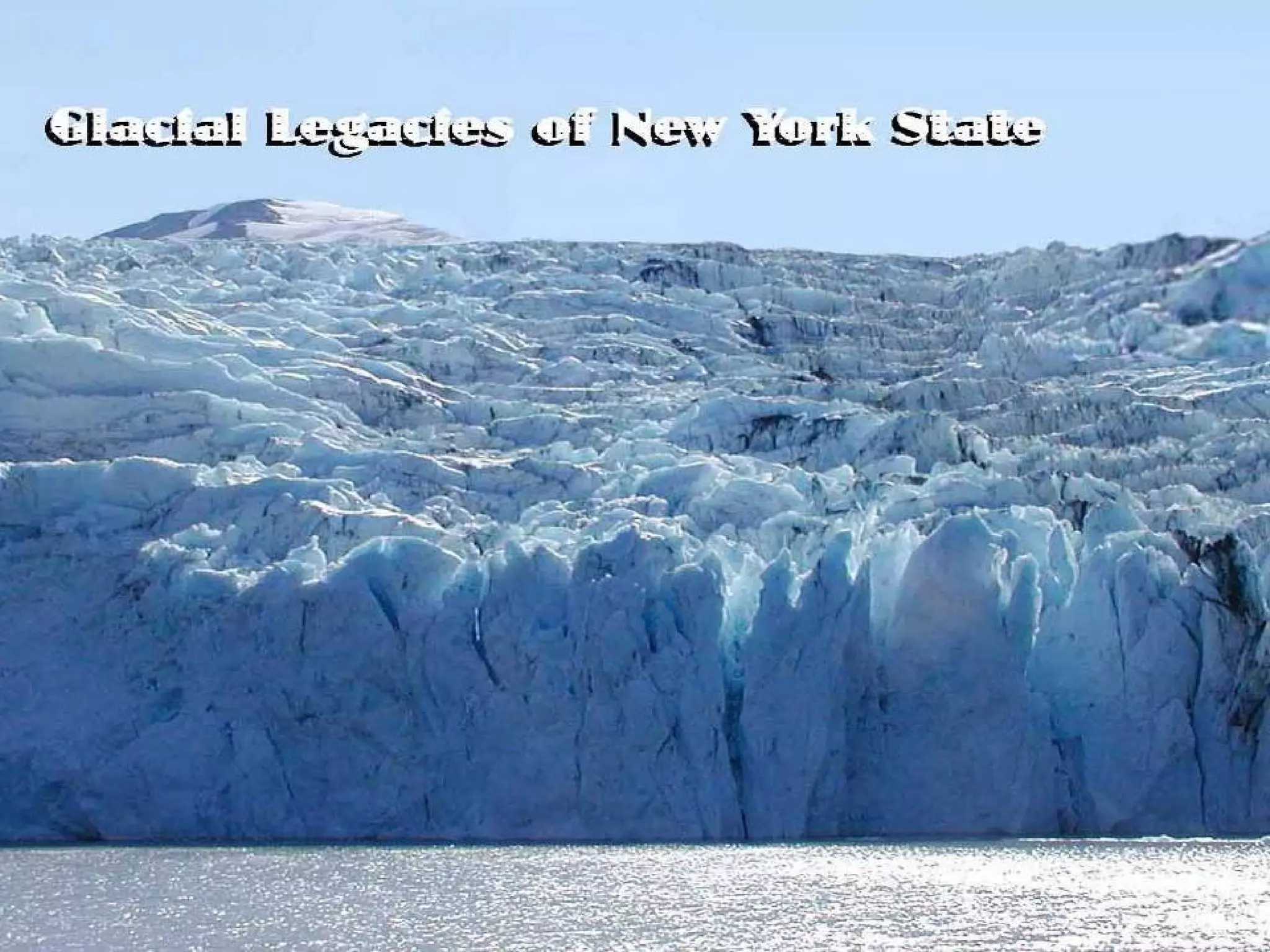
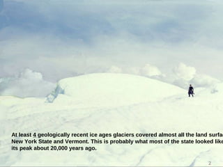
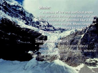
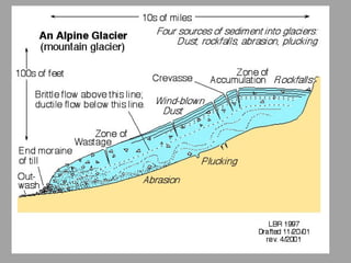
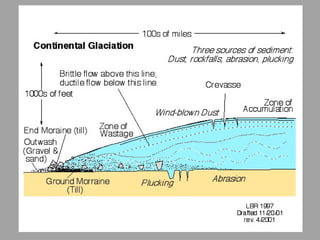
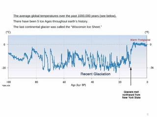
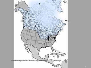
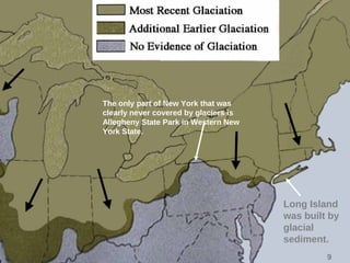
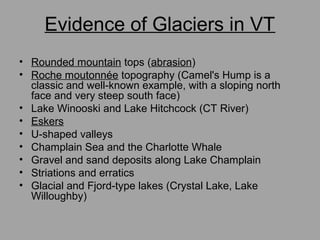
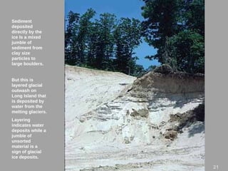
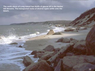
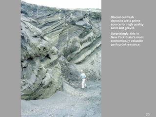
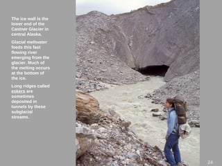
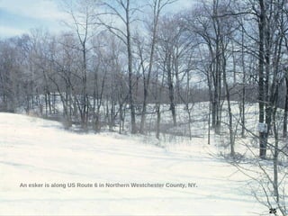
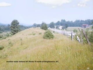
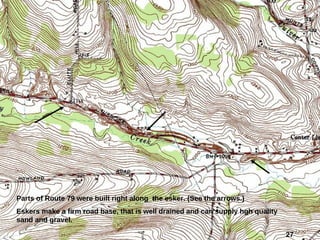
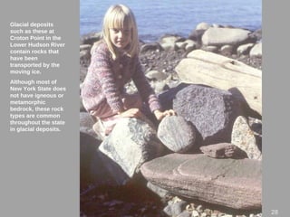
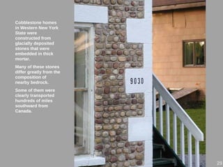
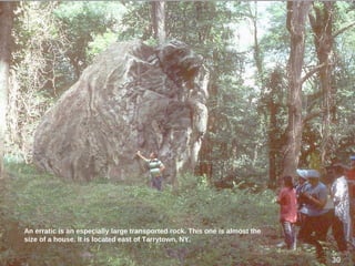
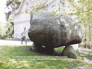
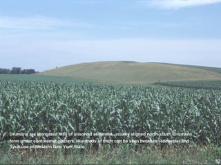
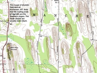
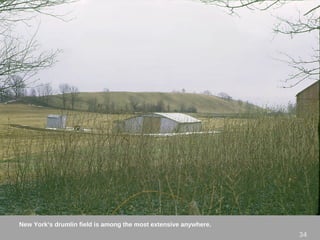
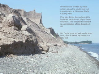
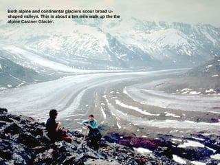
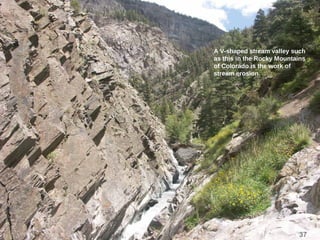
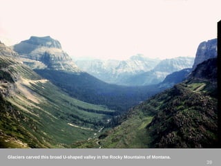
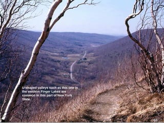
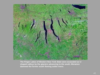
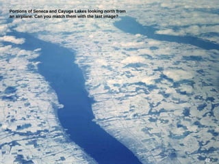
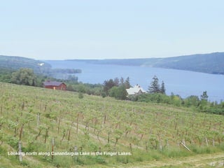
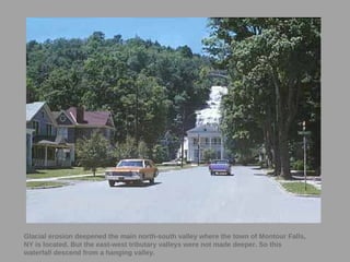
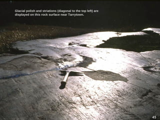
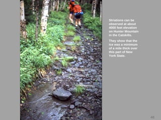
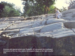
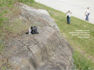
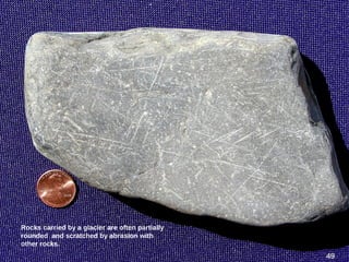
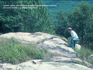
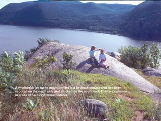
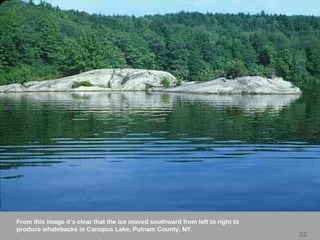
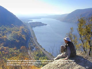
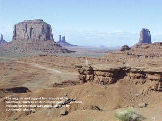
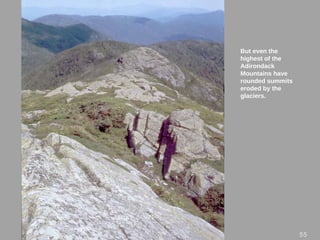
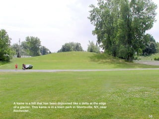
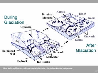
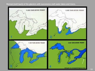
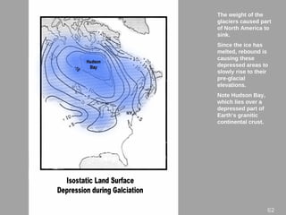
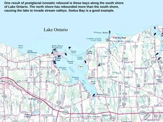
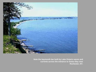
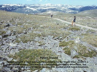
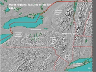
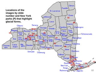
At least 4 geologically recent ice ages glaciers covered almost all the land surfac
New York State and Vermont. This is probably what most of the state looked like
its peak about 20,000 years ago.
2
3
GlacierGlacier::
•• A mass of ice and surficial snowA mass of ice and surficial snow
that persists throughout the year andthat persists throughout the year and
flows outward or downhill like a fluidflows outward or downhill like a fluid
under its own weight. Most range inunder its own weight. Most range in
size from 100 meters to 10,000size from 100 meters to 10,000
kilometers.kilometers.
Two types of glaciers:Two types of glaciers:
• AlpineAlpine (form in mountains/valleys)(form in mountains/valleys)
• ContinentalContinental (exist at the poles, advance(exist at the poles, advance
covering continents)covering continents)
6
The average global temperatures over the past 1000,000 years (see below).
There have been 5 Ice Ages throughout earth’s history.
The last continental glacier was called the “Wisconsin Ice Sheet.”
6
What causes Ice Ages?
• Milankovitch Theory: small, regular
changes in the earth’s orbit and in the tilt
of earth’s axis cause Ice Ages.
» Shape of earth’s orbit changes every 100,000
thousand years. Elliptical to circular and back
» Tilt of earth’s orbit: (21.5 to 24.5 degrees)
» Precession: circular movement of earth’s axis.
• Other: irregularities of the sun, volcanic
dust, or position of the continents.
8
Ice coverage of North America approximately 21,000 years ago
99
The only part of New York that was
clearly never covered by glaciers is
Allegheny State Park in Western New
York State.
Long Island
was built by
glacial
sediment.
Evidence of Glaciers in VT
• Rounded mountain tops (abrasion)
• Roche moutonnée topography (Camel's Hump is a
classic and well-known example, with a sloping north
face and very steep south face)
• Lake Winooski and Lake Hitchcock (CT River)
• Eskers
• U-shaped valleys
• Champlain Sea and the Charlotte Whale
• Gravel and sand deposits along Lake Champlain
• Striations and erratics
• Glacial and Fjord-type lakes (Crystal Lake, Lake
Willoughby)
11
The alpine Athabaska Glacier in Alberta, Canada is one of
the most accessible modern glaciers. Note the road and
cars parked left of the melt water lake.
Which type of glacier is this?
12
Glaciers push, drag and carry great quantities of
sediment from clay size to boulders. The blue lines
show the far edge of this glacier about a quarter mile
away.
This is the Castner Glacier in Alaska.
1212
Two lateral (side) moraines beside the Athabaska glacier. Ice
flowing in the valley to the right has pushed these ridges of
unsorted till into place.
1313
14
Debris from the continental glaciers was left behind as
irregular terrain such as this terminal (end) moraine on Cape
Cod. 14
15
Locations of moraine deposits in New York
State
Glacial till sediment, in
some places hundreds
of feet thick, covers
most of New York
State.
What can we say about
the “sorting” of glacial
till?
16
Within moraines closed depressions are common. Some may have been created
by a block of ice melting within the glacial deposits. Here we see ice on a former
water surface. The ice makes this kettle northwest of Oneonta especially visible.
17
Terminal moraines form the backbone of Long Island and extend to the east.
18
19
The Ronkokoma Moraine dips below sea level at
Montauk Point. This is New York’s most eastern
landfall. Note the boulders washed out of the
moraine.
19
This hummocky, irregular land surface south of Naples, NY
is a part of the Valley Heads Moraine. The irregular land
surface and kettle holes are typical of moraines.
20
21
Sediment
deposited
directly by the
ice Is a mixed
jumble of
sediment from
clay size
particles to
large boulders.
But this is
layered glacial
outwash on
Long Island that
is deposited by
water from the
melting glaciers.
Layering
indicates water
deposits while a
jumble of
unsorted
material is a
sign of glacial
ice deposits.
The north shore of Long Island has bluffs of glacial till in the Harbor
Hill Moraine. The transported rocks of diverse types settle onto the
beach.
2222
Glacial outwash
deposits are a prime
source for high quality
sand and gravel.
Surprisingly. this is
New York State’s most
economically valuable
geological resource.
23
The ice wall is the
lower end of the
Castner Glacier in
central Alaska.
Glacial meltwater
feeds this fast
flowing river
emerging from the
glacier. Much of
the melting occurs
at the bottom of
the ice.
Long ridges called
eskers are
sometimes
deposited in
tunnels by these
subglacial
streams.
24
An esker is along US Route 6 in Northern Westchester County, NY.
25
Another esker follows NY Route 79 north of Binghamton, NY.
26
27
Parts of Route 79 were built right along the esker. (See the arrows.)
Eskers make a firm road base, that is well drained and can supply hgh quality
sand and gravel.
Glacial deposits
such as these at
Croton Point in the
Lower Hudson River
contain rocks that
have been
transported by the
moving ice.
Although most of
New York State does
not have igneous or
metamorphic
bedrock, these rock
types are common
throughout the state
in glacial deposits.
28
Cobblestone homes
in Western New York
State were
constructed from
glacially deposited
stones that were
embedded in thick
mortar.
Many of these stones
differ greatly from the
composition of
nearby bedrock.
Some of them were
clearly transported
hundreds of miles
southward from
Canada.
29
An erratic is an especially large transported rock. This one is almost the
size of a house. It is located east of Tarrytown, NY.
3030
Occasionally an erratic is left perched on top of smaller boulders
after many years of erosion. This perched erratic is at North Salem
in Westchester County.
31
Drumlins are elongated hills of unsorted sediment, usually aligned north-south. Drumlins
form under continental glaciers. Hundreds of them can be seen between Rochester and
Syracuse in Western New York State.
32
This is pat of drumlin
field east of
Rochester, NY. Note
that the trailing ends
of the hills are the
southern slopes. The
north slopes are
usually more blunt.
33
New York’s drumlin field is among the most extensive anywhere.
34
Drumlins are eroded by wave
action along the south shore of
Lake Ontario at Chimney Bluffs
County Park.
Fine clay binds the sediment the
includes particles as big as large
boulders. The unsorted sediment
is an indication of ice deposited
till.
Mr. Coyle grew up half a mile from
here, this is where he swam as a
little kid!
35
36
Both alpine and continental glaciers scour broad U-
shaped valleys. This is about a ten mile walk up the the
alpine Castner Glacier.
36
37
A V-shaped stream valley such
as this in the Rocky Mountains
of Colorado is the work of
stream erosion.
Some New York streams, including
the Genesee River in Letchworth
Gorge carve out narrow V-shaped
valleys.
38
Glaciers carved this broad U-shaped valley in the Rocky Mountains of Montana.
39
U-shaped valleys such as this one in
the western Finger Lakes are
common in this part of New York
State.
4040
The Finger Lakes of Western New York State were excavated as U-
shaped valleys by the glaciers advancing to the south. Moraines
dammed the former south flowing outlet rivers.
4141
Portions of Seneca and Cayuga Lakes looking north from
an airplane. Can you match them with the last image?
42
Looking north along Canandaigua Lake in the Finger Lakes.
43
44
Glacial erosion deepened the main north-south valley where the town of Montour Falls,
NY is located. But the east-west tributary valleys were not made deeper. So this
waterfall descend from a hanging valley.
Glacial polish and striations (diagonal to the top left) are
displayed on this rock surface near Tarrytown.
45
46
Striations can be
observed at about
4000 feet elevation
on Hunter Mountain
in the Catskills.
They show that the
ice was a minimum
of a mile thick over
this part of New
York State.
47
Grooves and glacial polish near Peekskill, NY document the southward
movement of the ice. Also notice the stepped edges on the right (south)
side.
47
48
Glacially carved
grooves are common in
the hard rocks of the
Adirondacks.
48
Rocks carried by a glacier are often partially
rounded and scratched by abrasion with
other rocks.
49
Chatter marks and crescent gouges on hard bedrock surfaces
are more evidence of glacial movement.
5050
50
51
A whaleback (or roche mountonnée) is a bedrock surface that has been
scoured on the north side and plucked on the south end. They are common
in areas of hard crystalline bedrock.
51
52
From this image it’s clear that the ice moved southward from left to right to
produce whalebacks in Canopus Lake, Putnam County, NY.
52
53
The Hudson River Valley from Cornwall to Peekskill is the only glacially carved
fjord on the east coast of North America. Ocean vessels can travel all the way up
to Federal Dam north of Albany.
53
The angular and jagged landscapes of the
Southwest such as at Monument Valley in Arizona,
indicate an area that was never covered by
continental glaciers.
54
But even the
highest of the
Adirondack
Mountains have
rounded summits
eroded by the
glaciers.
5555
A kame is a hill that has been deposited like a delta at the edge
of a glacier. This kame is in a town park in Shortsville, NY, near
Rochester.
56
57
How selected features of continental glaciation, including kames, originated.
Retreat (melt back) of the glaciers with successive melt water lakes and rivers.
58
59
One of the melt water channels created a waterfall more
powerful than Niagara Falls that fell over these cliffs at Clark
Reservation in Syracuse. As you see, the waterfall is now dry
except for the plunge pool at the bottom.
At Croton Point in the Lower Hudson Valley, till with unsorted
sediment can be seen. Below the till are fine grained fresh
water lake deposits with annual layers. These are known as
varves. Clay varves document the age of post-glacial Lake
Albany.
6060
61
The courses of both the Niagara River and the Genesee River were changed causing
them to make dramatic new gorges and waterfalls.
The weight of the
glaciers caused part
of North America to
sink.
Since the ice has
melted, rebound is
causing these
depressed areas to
slowly rise to their
pre-glacial
elevations.
Note Hudson Bay,
which lies over a
depressed part of
Earth’s granitic
continental crust.
62
63
One result of postglacial isostatic rebound is these bays along the south shore
of Lake Ontario. The north shore has rebounded more than the south shore,
causing the lake to invade stream valleys. Sodus Bay is a good example.
Lake Ontario
64
Note the baymouth bar built by Lake Ontario waves and
currents across the entrance to Sodus Bay near
Rochester, NY.
64
Pattern Ground
Pattern ground is rock pushed into polygons by the freeze-thaw cycles in a
post-glacial climate. This image is a location in the Rocky Mountains, but
similar patterned ground can be observed in some Catskill forest locations.
6565
Finger Lakes
Drumlin Field
Long Island
Moraines
Polish,
Grooves
Striations
Major regional features of the ice
ages.
Valley Heads Moraine
Rounded
Mountain
Tops
Post-glacial Lakes
66
Eskers,
Kames
Till
banks
Changed
stream
channels
The end.
(…or is a new ice age right around the
corner?)
67
Locations of the
images by slide
number and New York
parks (P) that highlight
glacial forms.
P
68
P
P
13
14
16
17
18
18
19
20
22
25
26
28
29
30
31
32
34
35
38
4043
44
45
46
47
48
50
53
51 52
55
56
60
64
P
P P
61 P
P
P
P
P P
P
P
21
59

Glacial legacies new

  • 2.
    At least 4geologically recent ice ages glaciers covered almost all the land surfac New York State and Vermont. This is probably what most of the state looked like its peak about 20,000 years ago. 2
  • 3.
    3 GlacierGlacier:: •• A massof ice and surficial snowA mass of ice and surficial snow that persists throughout the year andthat persists throughout the year and flows outward or downhill like a fluidflows outward or downhill like a fluid under its own weight. Most range inunder its own weight. Most range in size from 100 meters to 10,000size from 100 meters to 10,000 kilometers.kilometers. Two types of glaciers:Two types of glaciers: • AlpineAlpine (form in mountains/valleys)(form in mountains/valleys) • ContinentalContinental (exist at the poles, advance(exist at the poles, advance covering continents)covering continents)
  • 6.
    6 The average globaltemperatures over the past 1000,000 years (see below). There have been 5 Ice Ages throughout earth’s history. The last continental glacier was called the “Wisconsin Ice Sheet.” 6
  • 7.
    What causes IceAges? • Milankovitch Theory: small, regular changes in the earth’s orbit and in the tilt of earth’s axis cause Ice Ages. » Shape of earth’s orbit changes every 100,000 thousand years. Elliptical to circular and back » Tilt of earth’s orbit: (21.5 to 24.5 degrees) » Precession: circular movement of earth’s axis. • Other: irregularities of the sun, volcanic dust, or position of the continents.
  • 8.
    8 Ice coverage ofNorth America approximately 21,000 years ago
  • 9.
    99 The only partof New York that was clearly never covered by glaciers is Allegheny State Park in Western New York State. Long Island was built by glacial sediment.
  • 10.
    Evidence of Glaciersin VT • Rounded mountain tops (abrasion) • Roche moutonnée topography (Camel's Hump is a classic and well-known example, with a sloping north face and very steep south face) • Lake Winooski and Lake Hitchcock (CT River) • Eskers • U-shaped valleys • Champlain Sea and the Charlotte Whale • Gravel and sand deposits along Lake Champlain • Striations and erratics • Glacial and Fjord-type lakes (Crystal Lake, Lake Willoughby)
  • 11.
    11 The alpine AthabaskaGlacier in Alberta, Canada is one of the most accessible modern glaciers. Note the road and cars parked left of the melt water lake. Which type of glacier is this?
  • 12.
    12 Glaciers push, dragand carry great quantities of sediment from clay size to boulders. The blue lines show the far edge of this glacier about a quarter mile away. This is the Castner Glacier in Alaska. 1212
  • 13.
    Two lateral (side)moraines beside the Athabaska glacier. Ice flowing in the valley to the right has pushed these ridges of unsorted till into place. 1313
  • 14.
    14 Debris from thecontinental glaciers was left behind as irregular terrain such as this terminal (end) moraine on Cape Cod. 14
  • 15.
    15 Locations of morainedeposits in New York State
  • 16.
    Glacial till sediment,in some places hundreds of feet thick, covers most of New York State. What can we say about the “sorting” of glacial till? 16
  • 17.
    Within moraines closeddepressions are common. Some may have been created by a block of ice melting within the glacial deposits. Here we see ice on a former water surface. The ice makes this kettle northwest of Oneonta especially visible. 17
  • 18.
    Terminal moraines formthe backbone of Long Island and extend to the east. 18
  • 19.
    19 The Ronkokoma Morainedips below sea level at Montauk Point. This is New York’s most eastern landfall. Note the boulders washed out of the moraine. 19
  • 20.
    This hummocky, irregularland surface south of Naples, NY is a part of the Valley Heads Moraine. The irregular land surface and kettle holes are typical of moraines. 20
  • 21.
    21 Sediment deposited directly by the iceIs a mixed jumble of sediment from clay size particles to large boulders. But this is layered glacial outwash on Long Island that is deposited by water from the melting glaciers. Layering indicates water deposits while a jumble of unsorted material is a sign of glacial ice deposits.
  • 22.
    The north shoreof Long Island has bluffs of glacial till in the Harbor Hill Moraine. The transported rocks of diverse types settle onto the beach. 2222
  • 23.
    Glacial outwash deposits area prime source for high quality sand and gravel. Surprisingly. this is New York State’s most economically valuable geological resource. 23
  • 24.
    The ice wallis the lower end of the Castner Glacier in central Alaska. Glacial meltwater feeds this fast flowing river emerging from the glacier. Much of the melting occurs at the bottom of the ice. Long ridges called eskers are sometimes deposited in tunnels by these subglacial streams. 24
  • 25.
    An esker isalong US Route 6 in Northern Westchester County, NY. 25
  • 26.
    Another esker followsNY Route 79 north of Binghamton, NY. 26
  • 27.
    27 Parts of Route79 were built right along the esker. (See the arrows.) Eskers make a firm road base, that is well drained and can supply hgh quality sand and gravel.
  • 28.
    Glacial deposits such asthese at Croton Point in the Lower Hudson River contain rocks that have been transported by the moving ice. Although most of New York State does not have igneous or metamorphic bedrock, these rock types are common throughout the state in glacial deposits. 28
  • 29.
    Cobblestone homes in WesternNew York State were constructed from glacially deposited stones that were embedded in thick mortar. Many of these stones differ greatly from the composition of nearby bedrock. Some of them were clearly transported hundreds of miles southward from Canada. 29
  • 30.
    An erratic isan especially large transported rock. This one is almost the size of a house. It is located east of Tarrytown, NY. 3030
  • 31.
    Occasionally an erraticis left perched on top of smaller boulders after many years of erosion. This perched erratic is at North Salem in Westchester County. 31
  • 32.
    Drumlins are elongatedhills of unsorted sediment, usually aligned north-south. Drumlins form under continental glaciers. Hundreds of them can be seen between Rochester and Syracuse in Western New York State. 32
  • 33.
    This is patof drumlin field east of Rochester, NY. Note that the trailing ends of the hills are the southern slopes. The north slopes are usually more blunt. 33
  • 34.
    New York’s drumlinfield is among the most extensive anywhere. 34
  • 35.
    Drumlins are erodedby wave action along the south shore of Lake Ontario at Chimney Bluffs County Park. Fine clay binds the sediment the includes particles as big as large boulders. The unsorted sediment is an indication of ice deposited till. Mr. Coyle grew up half a mile from here, this is where he swam as a little kid! 35
  • 36.
    36 Both alpine andcontinental glaciers scour broad U- shaped valleys. This is about a ten mile walk up the the alpine Castner Glacier. 36
  • 37.
    37 A V-shaped streamvalley such as this in the Rocky Mountains of Colorado is the work of stream erosion.
  • 38.
    Some New Yorkstreams, including the Genesee River in Letchworth Gorge carve out narrow V-shaped valleys. 38
  • 39.
    Glaciers carved thisbroad U-shaped valley in the Rocky Mountains of Montana. 39
  • 40.
    U-shaped valleys suchas this one in the western Finger Lakes are common in this part of New York State. 4040
  • 41.
    The Finger Lakesof Western New York State were excavated as U- shaped valleys by the glaciers advancing to the south. Moraines dammed the former south flowing outlet rivers. 4141
  • 42.
    Portions of Senecaand Cayuga Lakes looking north from an airplane. Can you match them with the last image? 42
  • 43.
    Looking north alongCanandaigua Lake in the Finger Lakes. 43
  • 44.
    44 Glacial erosion deepenedthe main north-south valley where the town of Montour Falls, NY is located. But the east-west tributary valleys were not made deeper. So this waterfall descend from a hanging valley.
  • 45.
    Glacial polish andstriations (diagonal to the top left) are displayed on this rock surface near Tarrytown. 45
  • 46.
    46 Striations can be observedat about 4000 feet elevation on Hunter Mountain in the Catskills. They show that the ice was a minimum of a mile thick over this part of New York State.
  • 47.
    47 Grooves and glacialpolish near Peekskill, NY document the southward movement of the ice. Also notice the stepped edges on the right (south) side. 47
  • 48.
    48 Glacially carved grooves arecommon in the hard rocks of the Adirondacks. 48
  • 49.
    Rocks carried bya glacier are often partially rounded and scratched by abrasion with other rocks. 49
  • 50.
    Chatter marks andcrescent gouges on hard bedrock surfaces are more evidence of glacial movement. 5050 50
  • 51.
    51 A whaleback (orroche mountonnée) is a bedrock surface that has been scoured on the north side and plucked on the south end. They are common in areas of hard crystalline bedrock. 51
  • 52.
    52 From this imageit’s clear that the ice moved southward from left to right to produce whalebacks in Canopus Lake, Putnam County, NY. 52
  • 53.
    53 The Hudson RiverValley from Cornwall to Peekskill is the only glacially carved fjord on the east coast of North America. Ocean vessels can travel all the way up to Federal Dam north of Albany. 53
  • 54.
    The angular andjagged landscapes of the Southwest such as at Monument Valley in Arizona, indicate an area that was never covered by continental glaciers. 54
  • 55.
    But even the highestof the Adirondack Mountains have rounded summits eroded by the glaciers. 5555
  • 56.
    A kame isa hill that has been deposited like a delta at the edge of a glacier. This kame is in a town park in Shortsville, NY, near Rochester. 56
  • 57.
    57 How selected featuresof continental glaciation, including kames, originated.
  • 58.
    Retreat (melt back)of the glaciers with successive melt water lakes and rivers. 58
  • 59.
    59 One of themelt water channels created a waterfall more powerful than Niagara Falls that fell over these cliffs at Clark Reservation in Syracuse. As you see, the waterfall is now dry except for the plunge pool at the bottom.
  • 60.
    At Croton Pointin the Lower Hudson Valley, till with unsorted sediment can be seen. Below the till are fine grained fresh water lake deposits with annual layers. These are known as varves. Clay varves document the age of post-glacial Lake Albany. 6060
  • 61.
    61 The courses ofboth the Niagara River and the Genesee River were changed causing them to make dramatic new gorges and waterfalls.
  • 62.
    The weight ofthe glaciers caused part of North America to sink. Since the ice has melted, rebound is causing these depressed areas to slowly rise to their pre-glacial elevations. Note Hudson Bay, which lies over a depressed part of Earth’s granitic continental crust. 62
  • 63.
    63 One result ofpostglacial isostatic rebound is these bays along the south shore of Lake Ontario. The north shore has rebounded more than the south shore, causing the lake to invade stream valleys. Sodus Bay is a good example. Lake Ontario
  • 64.
    64 Note the baymouthbar built by Lake Ontario waves and currents across the entrance to Sodus Bay near Rochester, NY. 64
  • 65.
    Pattern Ground Pattern groundis rock pushed into polygons by the freeze-thaw cycles in a post-glacial climate. This image is a location in the Rocky Mountains, but similar patterned ground can be observed in some Catskill forest locations. 6565
  • 66.
    Finger Lakes Drumlin Field LongIsland Moraines Polish, Grooves Striations Major regional features of the ice ages. Valley Heads Moraine Rounded Mountain Tops Post-glacial Lakes 66 Eskers, Kames Till banks Changed stream channels
  • 67.
    The end. (…or isa new ice age right around the corner?) 67
  • 68.
    Locations of the imagesby slide number and New York parks (P) that highlight glacial forms. P 68 P P 13 14 16 17 18 18 19 20 22 25 26 28 29 30 31 32 34 35 38 4043 44 45 46 47 48 50 53 51 52 55 56 60 64 P P P 61 P P P P P P P P 21 59