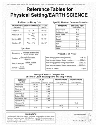
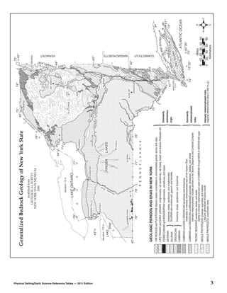
NYS Landforms                                                                                                                               Page 1 of 1


                                                                 Preview page as viewer (Mobile | Desktop)


NYS
                                                                                                                                            Search this site


 NYS Landforms
 Home
 Adirondack Mountains
 Finger Lakes
 Niagara Falls
 Howe Caverns
 Thousand Islands
 Moraines and Drumlins
 Glaciers
 Teacher Page
 Rubrics and Student Forms
 Google Maps Landform Locations


 This project exceeds the
 requirements set forth in the
 assignment and receives this seal
 of excellence in recognition of
 work well done.

                                     Sign in | Recent Site Activity | Report Abuse | Print Page | Remove Access | Powered By Google Sites


https://sites.google.com/site/nyslandforms/home?previewAsViewer=1                                                                               7/8/2012
Adirondack Mountains - NYS Landforms                                                                                                          Page 1 of 1


                                                                 Preview page as viewer (Mobile | Desktop)


NYS
                                                                                                                                              Search this site


 NYS Landforms
 Home
                                        Adirondack Mountains
 Adirondack Mountains
 Finger Lakes
 Niagara Falls                          Towering above New York's
                                        landscape, the Adirondack
 Howe Caverns
                                        Mountains stand as a monument to
 Thousand Islands                       the ice age. Five million years ago,
 Moraines and Drumlins                  small alpine glaciers carved their
 Glaciers                               way through the Northeastern
                                        United States. As they moved
 Teacher Page
                                        through what is now the Adirondack
 Rubrics and Student Forms              Region, stones deposited by the
 Google Maps Landform Locations         glacier were scattered across the
                                        landscape. Massive chunks of ice
                                        broke away from the glacier, and
                                        were buried beneath sand and
                                        gravel washed from the ice. As
                                        these ice chunks melted,
                                        depressions, called kettle holes,
                                        were formed. When the kettle hole
                                        extended below the water table, a
                                        pond was created. Many of the
                                        small, circular ponds you see while hiking in the high peak began as kettle holes.

                                        Over thousands of years, as glaciers carved away the landscape, the mountains began to take shape. Unlike the
                                        Rockies and the Appalachians, the Adirondack Mountains do not form a connected range, but rather a 160-mile
                                        wide dome of more than 100 peaks. Although the mountains are formed from ancient rocks more than 1,000
                                        million years old, geologically, the dome is a newborn. The Adirondack Peaks can be anywhere from 1,200 feet
 This project exceeds the               tall to well over 5,000 feet tall, and the 46 tallest summits above 4,000 feet are called the High Peaks. Although
 requirements set forth in the          four peaks were later discovered to measure less than 4,000 feet, they are still considered Adirondack High
 assignment and receives this seal      Peaks.
 of excellence in recognition of
 work well done.                        The highest of all the peaks is Mount Marcy, towering 5,344 feet above sea level. It is one of the most distinctive
                                        features of the Adirondack landscape. Mount Marcy is home to Lake Tear of the Clouds, the highest lake in New
                                        York State at 4,292 feet, and the source of the Hudson River. The Adirondack Mountains are about 6 million
                                        acres of forests, streams, rivers, lakes, and mounatins. They are located in Northern New York, about 225 miles
                                        north of New York City and 75 miles south of Montreal, Canada. In 1892 the Adirondacks were named a State
                                        Park. (Ref: http://visitadirondacks.com/adirondack-mountains.html)

                                        Interesting Facts About the Adirondack Mountains

                                             •   Mt. Marcy is the tallest of the Adirondack Mountains at 5,344 ft.
                                             •   There are 2,000 miles of foot trails.
                                             •   There are 2,300 lakes & ponds.
                                             •   There are 1,500 miles of rivers.


                                     Sign in | Recent Site Activity | Report Abuse | Print Page | Remove Access | Powered By Google Sites


https://sites.google.com/site/nyslandforms/about-us?previewAsViewer=1                                                                             7/8/2012
Finger Lakes - NYS Landforms                                                                                                                Page 1 of 1


                                                                 Preview page as viewer (Mobile | Desktop)


NYS
                                                                                                                                            Search this site


 NYS Landforms
 Home
                                        Finger Lakes
 Adirondack Mountains
 Finger Lakes
 Niagara Falls                          The Finger Lakes are made up
                                        of eleven lakes. Their
 Howe Caverns
                                        names, from east to west, are:
 Thousand Islands                       Otisco, Skaneateles, Owasco,
 Moraines and Drumlins                  Cayuga, Seneca, Keuka,
 Glaciers                               Canandaigua, Honeoye,
                                        Canadice, Hemlock, and
 Teacher Page
                                        Conesus. They are called finger
 Rubrics and Student Forms              lakes because they are shaped
 Google Maps Landform Locations         like the fingers of a hand.

                                        During the last Ice Age, the ice
                                        was over a mile thick. As time
                                        went on, the ice sheet grew and
                                        with its force created valleys,
                                        lakes, rivers, and even rounded
                                        mountain ranges. As this
                                        glacier withdrew, it carved out
                                        valleys. Then, as the glacier
                                        melted, the waters began to fill
                                        these new valleys forming the
                                        Finger Lakes. The deep weight of the glacier made some parts of this area deeper than others. The Finger
                                        Lakes are stretched in the direction of the ice movement. This is how the different shapes and sizes of the Finger
                                        Lakes came to be. (Ref: http://www.fingerlakes.org/)

                                        Interesting Facts About the Finger Lakes
 This project exceeds the
 requirements set forth in the
 assignment and receives this seal
                                             • Cayuga Lake is 40 miles long and 1 to 3 miles wide, 435 feet deep and 380 feet above sea level.
 of excellence in recognition of             • Cayuga and Seneca Lake are connected at their northern ends by a canal.
 work well done.                             • The Finger Lakes are home to more than 100 wineries.


                                     Sign in | Recent Site Activity | Report Abuse | Print Page | Remove Access | Powered By Google Sites


https://sites.google.com/site/nyslandforms/finger-lakes?previewAsViewer=1                                                                        7/8/2012
Niagara Falls - NYS Landforms                                                                                                               Page 1 of 1


                                                                 Preview page as viewer (Mobile | Desktop)


NYS
                                                                                                                                            Search this site


 NYS Landforms
 Home
                                        Niagara Falls
 Adirondack Mountains
 Finger Lakes
 Niagara Falls                          During the last ice age, a
                                        large sheet of ice covered
 Howe Caverns
                                        Canada and parts of New
 Thousand Islands                       York. As this sheet of ice
 Moraines and Drumlins                  started to melt, water began
 Glaciers                               to flow back to the ocean
                                        through a channel that went
 Teacher Page
                                        across New York to the
 Rubrics and Student Forms              Hudson River Valley. As the
 Google Maps Landform Locations         flow continued, the water
                                        levels began to drop.
                                        Eventually, a new channel
                                        was exposed which would
                                        become the Niagara River.
                                        Water from Lake Erie now
                                        flowed into Lake Iroquois (the
                                        name for a lake that stood
                                        where Lake Ontario is but
                                        was larger). As the last
                                        remaining parts of the sheet
                                        of ice melted from the Thousand Islands, a great rush of water drained Lake Iroquois through the St. Lawrence
                                        River and emptied into the Atlantic Ocean. Now the waters flowed from Lake Erie through the Niagara River into
                                        Lake Ontario and out the St. Lawrence River to the Atlantic Ocean. (Ref:
                                        http://www.niagarafallsstatepark.com/Formation-and-Discovery.aspx)

 This project exceeds the               Interesting Facts About Niagara Falls
 requirements set forth in the
 assignment and receives this seal           • A 7 year old boy wearing only life jacket and bathing suit accidentally went over the Canadian Falls and
 of excellence in recognition of               survived during the summer of 1960.
 work well done.                             • More than 6 million cubic feet of water goes over the falls every minute during peak daytime hours.
                                             • Niagara Falls is comprised of three waterfalls: American Falls, Bridal Veil Falls and Horseshoe Falls.
                                             • The Canadian Falls, shaped like a horseshoe, are 177 feet high and the American Falls are184 feet high.


                                     Sign in | Recent Site Activity | Report Abuse | Print Page | Remove Access | Powered By Google Sites


https://sites.google.com/site/nyslandforms/niagara-falls?previewAsViewer=1                                                                      7/8/2012
Howe Caverns - NYS Landforms                                                                                                                  Page 1 of 1


                                                                 Preview page as viewer (Mobile | Desktop)


NYS
                                                                                                                                              Search this site


 NYS Landforms
 Home
                                        Howe Caverns
 Adirondack Mountains
 Finger Lakes                           Howe Caverns is a limestone cave
 Niagara Falls                          located the eastern central part in
 Howe Caverns
                                        Schoharie County 156 feet
                                        underground. Since it is so far
 Thousand Islands                       underground, the temperature stays
 Moraines and Drumlins                  at 52 °F year round. Caverns are
 Glaciers                               very humid, which means they are
 Teacher Page                           not only cool but also damp. To
                                        explore the caverns you need to
 Rubrics and Student Forms              take a 32 second elevator ride
 Google Maps Landform Locations         underneath the earth. These
                                        caverns stretch a little less than a
                                        mile and end at an underground
                                        lake. During tours of the caverns,
                                        after walkting to the end, you are
                                        allowed to take a short boat ride on
                                        the underground lake.
                                        Like other landforms, Howe
                                        Caverns took a long time to form.
                                        At one time, this area would have
                                        been a solid piece of limestone.
                                        Over time, rain found its way into the limestone. As the rain fell from the sky it absorbed carbon dioxide and
                                        turned into a very weak carbonic acid. This acidic water slowly dissolved the limestone over thousands of
                                        years. As a result, chambers, rooms, and passageways were carved out ultimately creating the cavern as we
                                        know it today. (Ref: http://howecaverns.com/history)

 This project exceeds the               Intersting Facts About Howe Caverns
 requirements set forth in the
 assignment and receives this seal           • Lester Howe accidentally found Howe Caverns on May 22, 1842. Howe noticed that his cows seemed to be
 of excellence in recognition of               grazing in the same spot every day. When he went to find out why, the temperature seemed to be quite
 work well done.                               cooler where the cows were grazing. As he approached that same spot, he found an opening to the cave all
                                               because of one cow named Milicent that stood closest to the opening.
                                             • Howe Caverns has little animal or plant life. It is a closed ecological system, which means that the food web
                                               stays only in the cave.
                                             • Unique stone formations grow deep inside the caverns. Large formations known as stalactites grow down
                                               from the cavern ceilings. Large formations known as stalagmites grow up from the ground. (A neat way to
                                               learn the meanings of these terms and not be confused is to remember the “c” (grows down from ceiling) in
                                               stalactites and the “g” (grows up from ground) in .stalagmites.


                                     Sign in | Recent Site Activity | Report Abuse | Print Page | Remove Access | Powered By Google Sites


https://sites.google.com/site/nyslandforms/howe-caverns?previewAsViewer=1                                                                         7/8/2012
Thousand Islands - NYS Landforms                                                                                                             Page 1 of 1


                                                                 Preview page as viewer (Mobile | Desktop)


NYS
                                                                                                                                             Search this site


 NYS Landforms
 Home
                                        Thousand Islands
 Adirondack Mountains
 Finger Lakes
 Niagara Falls                          How many islands make up
                                        the Thousand Islands?
 Howe Caverns
                                        There are at least 1,700
 Thousand Islands                       islands between Canada and
 Moraines and Drumlins                  the United States in the
 Glaciers                               region called Thousand
                                        Islands in the St. Lawrence
 Teacher Page
                                        River. Most of the islands
 Rubrics and Student Forms              are relatively small, but there
 Google Maps Landform Locations         are a few that stretch 5 to 6
                                        miles long. These islands
                                        are found in about a 40-mile
                                        stretch on the river where it
                                        turns very wide as it leaves
                                        Lake Ontario. The
                                        Thousand Islands reach the
                                        Canadian side from Wolfe
                                        Island near Kingston, Ontario
                                        to Brockville, Ontario and
                                        goes over to the American
                                        side from Tibbets Point on
                                        Lake Ontario to Morristown,
                                        New York. Long before the
                                        French explorers found this area, this land was occupied by the five member nations of the Iroquois. This
                                        included the Mohawk, Oneida, Onondaga, Seneca, and the Cayuga Indians.
 This project exceeds the
 requirements set forth in the          During the last Ice Age, which happened about 18,000 years ago, the ice was over a mile thick. As time went on,
 assignment and receives this seal      the ice sheet grew and with its force, created valleys, lakes, rivers, and even rounded mountain ranges when it
 of excellence in recognition of        began to withdraw. It also crushed things that did not move like a huge bulldozer. As it withdrew, the glacier left
 work well done.                        a large channel to the valley. As the glacier melted, the waters began to fill this new channel. The deep weight of
                                        the glacier made some parts of this area deeper than others. This is how the different shapes and sizes of the
                                        Thousand Islands came to be. (Ref: http://oliver_kilian.tripod.com/1000islands/IsIn2-Rocks/rocks.htm)

                                        Interesting Facts About the Thousand Islands

                                             • There are at least 1,700 islands that make up the Thousand Islands.
                                             • Seventeen of these islands are included in the St. Lawrence Islands National Park.
                                             • First European settlement in this area was located in Kingston in 1675, with the opening of Fort Frontanac.


                                     Sign in | Recent Site Activity | Report Abuse | Print Page | Remove Access | Powered By Google Sites


https://sites.google.com/site/nyslandforms/thousand-islands?previewAsViewer=1                                                                    7/8/2012
Moraines and Drumlins - NYS Landforms                                                                                                          Page 1 of 1


                                                                 Preview page as viewer (Mobile | Desktop)


NYS
                                                                                                                                               Search this site


 NYS Landforms
 Home
                                        Moraines and Drumlins
 Adirondack Mountains
 Finger Lakes
 Niagara Falls                          The "Ice age" was really a
 Howe Caverns                           series of many advances
                                        and retreats of glaciers.
 Thousand Islands
                                        The Finger Lakes were
 Moraines and Drumlins                  probably carved by several
 Glaciers                               of these episodes. Ice
 Teacher Page                           sheets more than two miles
                                        thick flowed southward,
 Rubrics and Student Forms
                                        parallel but opposite to the
 Google Maps Landform Locations         flow of the rivers, gouging
                                        deep trenches into these
                                        river valleys. Traces of
                                        most of the earlier glacial
                                        events have vanished, but
                                        much evidence remains of
                                        the last one or two glaciers
                                        that covered New York.

                                        The latest glacial episode was most extensive around 21,000 years ago, when glaciers covered
                                        almost the entire state. Around 19,000 years ago, the climate warmed, and the glacier began to
                                        retreat, disappearing entirely from New York for the last time around 11,000 years ago.

                                        The most obvious evidence left by the glaciers are the gravel deposits at the south ends of the
                                        Finger Lakes called moraines and streamlined elongated hills of glacial sediment called drumlins.
                                        Moraines are visible south of Ithaca at North Spencer, along Route 13 west of Newfield, and near
 This project exceeds the               Willseyville. Drumlins are visible northeast of Ithaca at the northern end of Cayuga and Seneca
 requirements set forth in the          lakes in a broad band from Rochester to Syracuse. (Ref:
 assignment and receives this seal      http://www.britannica.com/EBchecked/topic/172086/drumlin)
 of excellence in recognition of
 work well done.                        Interesting Facts About Morains and Drumlins

                                              • The long axis of a drumlin lies parallel to the direction of the advance.
                                              • Drumlins can vary widely in size, with lengths from 0.6 to 1.2 miles, heights from 50 to 100
                                                feet, and widths from 1300 to 2000 feet.
                                              • Most drumlins are composed of till, but they may vary greatly in their composition. Some
                                                contain significant amounts of gravels, whereas others are made up of rock underlying the
                                                surface till.


                                     Sign in | Recent Site Activity | Report Abuse | Print Page | Remove Access | Powered By Google Sites


https://sites.google.com/site/nyslandforms/moraines-and-drumlins?previewAsViewer=1                                                                 7/8/2012
Glaciers - NYS Landforms                                                                                                                      Page 1 of 1


                                                                 Preview page as viewer (Mobile | Desktop)


NYS
                                                                                                                                              Search this site


 NYS Landforms
 Home
                                        Glaciers
 Adirondack Mountains
 Finger Lakes
 Niagara Falls                          Even though you've probably
                                        never seen a glacier, they are a
 Howe Caverns
                                        big item of importance when we
 Thousand Islands                       talk about New York State's
 Moraines and Drumlins                  geology.
 Glaciers
                                        In a way, glaciers are just frozen
 Teacher Page                           rivers of ice flowing downhill.
 Rubrics and Student Forms              Glaciers begin life as
 Google Maps Landform Locations         snowflakes. When the snowfall
                                        in an area far exceeds the
                                        melting that occurs during
                                        summer, glaciers start to form.
                                        The weight of the accumulated
                                        snow compresses the fallen
                                        snow into ice. These "rivers" of
                                        ice are tremendously heavy, and
                                        if they are on land that has a
                                        downhill slope the whole ice
                                        patch starts to slowly grind its
                                        way downhill. Even when they
                                        are melting and receeding they maintain their downhill movement. These glaciers can vary greatly in size, from a
                                        football-field sized patch to a river a hundred miles long.

                                        Glaciers have had a profound effect on the topography in NYS, other states in the northern U.S and in Canada.
                                        Imagine how a billion-ton ice cube can rearrange the landscape as it slowly grinds its way overland. In this picture
 This project exceeds the
 requirements set forth in the          you can see the bowl-shaped valley in a glacial valley glacier forces its way through the landscape. Many lakes,
 assignment and receives this seal      such as the Great Lakes, and valleys have been carved out by ancient glaciers. (Ref:
 of excellence in recognition of         http://ga.water.usgs.gov/edu/earthglacier.html)
 work well done.
                                        Interesting Facts About the Glaciers


                                             • During the last ice age (when glaciers covered more land area than today) the sea level was about 400 feet
                                               lower than it is today. At that time, glaciers covered almost one-third of the land.
                                             • During the last warm spell, 125,000 years ago, the seas were about 18 feet higher than they are today.
                                               About three million years ago the seas could have been up to 165 feet higher.
                                             • Glaciers store about 69% of the world's freshwater, and if all land ice melted the seas would rise about 70
                                               meters (about 230 feet).
                                             •


                                     Sign in | Recent Site Activity | Report Abuse | Print Page | Remove Access | Powered By Google Sites


https://sites.google.com/site/nyslandforms/glaciers?previewAsViewer=1                                                                             7/8/2012
Teacher Page - NYS Landforms                                                                                                                     Page 1 of 2


                                                            Preview page as viewer (Mobile | Desktop)


NYS
                                                                                                                                                 Search this site


 NYS Landforms
 Home
                                     Teacher Page
 Adirondack Mountains
 Finger Lakes                                                                                  Overview
 Niagara Falls
 Howe Caverns
                                     Note: This is one piece of what could be a full year project with each unit. It will be important for the teacher to be
                                     aware of each student’s situation so that alterations can be made for the independent portion if necessary.
 Thousand Islands                    Students will be working in groups, independently and with technology as well as making real world observations
 Moraines and Drumlins               and practicing real world reporting. Ideally this project could be taken on by schools across the state or country
 Glaciers                            and students could share their local landforms with each other.
 Teacher Page
                                             As students progress through a unit on landforms, they will use their observation skills in a real world
 Rubrics and Student Forms           application and then report their findings. Students will make observations, recall or research the processes that
 Google Maps Landform Locations      created the landforms, utilize digital photography, GPS technology and create a personal review website.
                                             Students will participate in a field trip to at least 3 local landforms that are discussed in class. At the end of
                                     the unit (following the field trip) each student will be responsible for creating their own website that will include their
                                     authentic photograph of the landform, their observations, formation information, GPS location, and three facts
                                     about the landform that the student found interesting.
                                             Students will work in groups of 3 to photograph, take GPS coordinate readings of their location, map it on a
                                     map (perhaps Google Earth) and make authentic observations.
                                     In addition to the 3 landforms observed on the field trip, each student will be required to independently seek out 1
                                     additional landform and complete all the previously mentioned components. Each student will then share their
                                     information on the landform with the others in their group. It will be the responsibility of each student to verify that
                                     the information that they include on their website is accurate and complete.
                                             If a student is unable to seek out a local landform on their own due to a lack of transportation or family
                                     responsibility, they will be allowed to research and use an available image of a well known landform.
                                             After the websites are completed, the teacher will grade them with the use of a rubric. Badges will be
                                     awarded as follows: 1-the teacher will award a “Teachers Seal of Excellence” to websites that meet and or
                                     surpasses all required elements. 2- Each student will view all classmates’ websites and choose a favorite. The one
 This project exceeds the            with the most votes will be awarded a “Class Favorite” badge.
 requirements set forth in the               Additionally, each student will be required to peer review 3 other students work (these may NOT be group
 assignment and receives this seal   members). Students will use the Peer Review Form.
 of excellence in recognition of             The goals of this project are to get students out of the classroom to actually see, touch and experience the
 work well done.                     landforms they have learned about and to work on their observation and reporting skills. Students will also benefit
                                     from group work and the sharing of their finding of their individual component.


                                                                                 Prior Knowledge and Standards

                                             As students begin this project, they will need some prior knowledge to successfully complete it. Students
                                     will need to understand that Landforms are the result of Earth processes and time. Students will need to have a
                                     basic knowledge of GPS and what it is used for as well as an understanding of how to make and report
                                     observations.


                                             Students will be exposed to many NYS standards during this project.

                                     Standard 2: Information Systems
                                             Key Idea 1: Information technology is used to retrieve, process, and communicate information as a tool to
                                            enhance learning.

                                             Key Idea 2: Knowledge of the impacts and limitations of information systems is essential to its effective
                                             and ethical use.

                                     Standard 6: Interconnectedness, Common Themes:
                                             Key Idea 1: Systems Thinking: Through systems thinking, people can recognize the commonalities that
                                     exist among all systems and how parts of a system interrelate and combine to perform specific
                                     functions

                                            Key Idea 3: Magnitude and Scale: The grouping of magnitudes of size, time, frequency, and pressures or
                                     other units of measurement into a series of relative order provides a useful way to deal with the immense range
                                     and the changes in scale that affect the behavior and design of systems.

                                     Standard 4, Key Idea 2, Performance Indicators
                                            2.1m Many processes of the rock cycle are consequences of plate dynamics. These include the production
                                     of magma (and subsequent igneous rock formation and contact metamorphism) at both subduction and rifting
                                     regions, regional metamorphism within subduction


https://sites.google.com/site/nyslandforms/teacher-page?previewAsViewer=1                                                                            7/8/2012
Teacher Page - NYS Landforms                                                                                                       Page 2 of 2


                         zones, and the creation of major depositional basins through down-warping of the crust.

                                2.1n Many of Earth’s surface features such as mid-ocean ridges/rifts, trenches/subduction zones/island
                         arcs, mountain ranges (folded, faulted, and volcanic), hot spots, and the magnetic and age patterns in surface
                         bedrock are a consequence of forces associated with plate motion and interaction.

                                2.1p Landforms are the result of the interaction of tectonic forces and the processes of
                         weathering, erosion, and deposition.
                                2.1r Climate variations, structure, and characteristics of bedrock influence the development of landscape
                         features including mountains, plateaus, plains, valleys, ridges,
                         escarpments, and stream drainage patterns.

                                 2.1t Natural agents of erosion, generally driven by gravity, remove, transport, and
                         deposit weathered rock particles. Each agent of erosion produces distinctive changes
                         in the material that it transports and creates characteristic surface features and landscapes. In certain erosional
                         situations, loss of property, personal injury, and loss of life can be reduced by effective emergency preparedness.

                                  2.1u The natural agents of erosion include:
                         • Streams (running water): Gradient, discharge, and channel shape influence a stream’s velocity and the erosion
                         and deposition of sediments. Sediments transported by streams tend to become rounded as a result of abrasion.
                         Stream features include V-shaped valleys, deltas, flood plains, and meanders. A watershed is the area drained by
                         a stream and its tributaries.
                         • Glaciers (moving ice): Glacial erosional processes include the formation of U-shaped valleys, parallel scratches,
                         and grooves in bedrock. Glacial features include moraines, drumlins, kettle lakes, finger lakes, and outwash
                         plains.
                         • Wave Action: Erosion and deposition cause changes in shoreline features, including beaches, sandbars, and
                         barrier islands. Wave action rounds sediments as a result of abrasion. Waves approaching a shoreline move sand
                         parallel to the shore within the zone of breaking waves.
                         • Wind: Erosion of sediments by wind is most common in arid climates and along shorelines. Wind-generated
                         features include dunes and sand-blasted bedrock.
                         • Mass Movement: Earth materials move downslope under the influence of gravity.

                                2.1v Patterns of deposition result from a loss of energy within the transporting system
                         and are influenced by the size, shape, and density of the transported particles. Sediment
                         deposits may be sorted or unsorted.


                               Teacher overview.pdf                             Benjamin Rosenthal,                          v.1


                      Sign in | Recent Site Activity | Report Abuse | Print Page | Remove Access | Powered By Google Sites


https://sites.google.com/site/nyslandforms/teacher-page?previewAsViewer=1                                                            7/8/2012
Rubrics and Student Forms - NYS Landforms                                                                                                         Page 1 of 1


                                                                   Preview page as viewer (Mobile | Desktop)


NYS
                                                                                                                                                  Search this site


 NYS Landforms
 Home
                                        Rubrics and Student Forms
 Adirondack Mountains
 Finger Lakes                                                                                   Landforms Project
 Niagara Falls
 Howe Caverns
                                               You will be putting your observation and reporting skills to work and creating your own review
                                        website that will help you get to know the wondrous world right outside your door!
 Thousand Islands
 Moraines and Drumlins                          As we move through our unit on landforms, we will be continually working towards each of you creating
 Glaciers                               your own website. Your website will include several components that will be useful to you especially when you
 Teacher Page                           begin to review for the final exam.
 Rubrics and Student Forms              You will be put into groups of 3. when we take our field trip to some local landforms, your group will be required to:
 Google Maps Landform Locations                    a. take a photograph of the landform,
                                                   b. take a GPS coordinate reading,
                                                   c. pin point the GPS reading on a map that will be put onto each of your websites,
                                                   d. make authentic observations and write them into your journals.
                                                 *You each will also be adding 3 interesting facts about each landform to your individual sites

                                                After the field trip you each will make your own website using the information that you gathered along with
                                        your independent landform observation and photo. Each of you will be required to individually seek out,
                                        identify, photograph, observe and describe one landform other than the ones found on the field trip.


                                         ***Attached is the rubric that explains the project and my expectations. Please see me if you have any questions
                                                                         or do not fully understand the project or directions.***


 This project exceeds the
 requirements set forth in the
 assignment and receives this seal
 of excellence in recognition of              Earth Science Reference Tables - 2011.pdf         Benjamin Rosenthal,                         v.1
 work well done.
                                              Peer Review Doc.pdf                               Benjamin Rosenthal,                         v.1


                                              Project Rubric.pdf                                Benjamin Rosenthal,                         v.1


                                              Student Field Trip Sheet.pdf                      Benjamin Rosenthal,                         v.1


                                              Student overview.pdf                              Benjamin Rosenthal,                         v.1


                                     Sign in | Recent Site Activity | Report Abuse | Print Page | Remove Access | Powered By Google Sites


https://sites.google.com/site/nyslandforms/rubrics-and-student-evaluation-forms?previewAs... 7/8/2012
The University of the State of New York • THE STATE EDUCATION DEPARTMENT • Albany, New York 12234 • www.nysed.gov


           Reference Tables for
     Physical Setting/EARTH SCIENCE
                 Radioactive Decay Data                                           Specific Heats of Common Materials
       RADIOACTIVE DISINTEGRATION HALF-LIFE                                                 MATERIAL               SPECIFIC HEAT
         ISOTOPE                   (years)                                                                          (Joules/gram • °C)
                                14         14                     3                     Liquid water                        4.18
       Carbon-14                     C       N             5.7 × 10
                                                                                        Solid water (ice)                   2.11
                                           40
                                40              Ar                9                     Water vapor                         2.00
       Potassium-40                  K     40              1.3 × 10
                                                Ca
                                                                                        Dry air                             1.01
                              238          206                    9
       Uranium-238                  U            Pb        4.5 × 10                     Basalt                              0.84
                                                                  10
                                                                                        Granite                             0.79
                               87           87
       Rubidium-87               Rb             Sr         4.9 × 10
                                                                                        Iron                                0.45
                                                                                        Copper                              0.38
                     Equations                                                          Lead                                0.13

                         distance between foci
        Eccentricity =                                                                    Properties of Water
                          length of major axis
                     change in field value                            Heat energy gained during melting . . . . . . . . . . 334 J/g
        Gradient =
                          distance
                                                                      Heat energy released during freezing . . . . . . . . 334 J/g
                            change in value                           Heat energy gained during vaporization . . . . . 2260 J/g
        Rate of change =
                                 time
                                                                      Heat energy released during condensation . . . 2260 J/g
                   mass
        Density =                                                     Density at 3.98°C . . . . . . . . . . . . . . . . . . . . . . . . 1.0 g/mL
                  volume


                                     Average Chemical Composition
                             of Earth’s Crust, Hydrosphere, and Troposphere
                 ELEMENT                                CRUST                        HYDROSPHERE                 TROPOSPHERE
                  (symbol)               Percent by mass     Percent by volume         Percent by volume          Percent by volume
            Oxygen (O)                          46.10             94.04                       33.0                       21.0
            Silicon (Si)                        28.20              0.88
            Aluminum (Al)                        8.23              0.48
            Iron (Fe)                            5.63              0.49
            Calcium (Ca)                         4.15              1.18
            Sodium (Na)                          2.36              1.11
            Magnesium (Mg)                       2.33              0.33
            Potassium (K)                        2.09              1.42
            Nitrogen (N)                                                                                                 78.0
            Hydrogen (H)                                                                      66.0
            Other                                0.91                 0.07                     1.0                         1.0


                            2011 EDITION                                                                                 Eurypterus remipes
This edition of the Earth Science Reference Tables should be used in the
classroom beginning in the 2011–12 school year. The first examination for
which these tables will be used is the January 2012 Regents Examination in
                                                                                                                       New York State Fossil
Physical Setting/Earth Science.
Generalized Landscape Regions of New York State
                                                                                                                                                                      ds
                                                                                                                                     Interior                       an
                                                                                                                                                                 wl
                                                                                                    Grenville Province              Lowlands               e   Lo
                                                                                                       (Highlands)                                    e nc
                                                                                                                                                  awr
                                                                                                                                          S  t. L

                                                                             Interior Lowlands
                                                                                                                                                                Adirondack
                                                                                                                                                                Mountains                               Champlain Lowlands

                                                                                                Lake Ontario
                                                                                                                                      Tug Hill
                                                                                                                                      Plateau
                                                                                                                                                                                                                                                   ce


Physical Setting/Earth Science Reference Tables — 2011 Edition
                                                                                                                                                                                                                                                in


                                                                                            Erie-Ontario Lowlands
                                                                                                   (Plains)
                                                                                                                                                                                                                                        d ov    s)


                                                                                                                                                                                                            s
                                                                                                                                                                                                                                      an Pr


                                                                 Lake Erie
                                                                                                                                                                                                                                   hl
                                                                                                                                                                                                                                 ig and


                                                                                                                                                                                                     untain
                                                                                                                                                                                                                                En
                                                                                                                                                                                                                              (H gl


                                                                                                                Allegheny Plateau
                                                                                                                                                                                                  Lowlands
                                                                                                                                                                                                                             ew
                                                                                                                                                                                                                             N

                                                                                                                                                                                              nic Mo


                                                                                                                                                           The Catskills
                                                                                                                                                                                         Mohawk
                                                                                                                                                                                         Taco
                                                                                                                                                                                     o n-


                                                                                                           s)                                                                                                                    nds
                                                                                                         nd                                                                                                                ighla
                                                                                                        a                                                                                                            on H
                                                                                                                                                                                Huds


                                                                                                      pl                                                                                                        H uds            ng
                                                                                                (   U                                                                                                                      n Pro
                                                                                            u                                                                                                                        hatta
                                                                                                                                                                                                                Man
                                                                                          ea
                                                                                     at              Key
                                                                                   Pl
                                                                                                                 Major geographic province boundary


                                                                              an
                                                                                                                                                                                                                                       lain
                                                                                                                                                                                                                                   al P


                                                                            hi
                                                                                                                                                                                                                                 st
                                                                                                                                                                                ds


                                                                                                                 Landscape region boundary


                                                                          c
                                                                                                                                                                                                                             Coa
                                                                                                                                                                             lan rk


                                                                                                                 State boundary                                                                  tic


                                                                       ala
                                                                                                                                                                           w
                                                                                                                                                                           N


                                                                                                                                                                                             lan


                                                                        p
                                                                                                                                                                                           At
                                                                                                                                                                         Lo ewa


                                                                                                                 International boundary


                                                                     Ap
                                                                                                                                                                                                                      Miles                          N
                                                                                                                                                                                                                0 10 20 30 40 50
                                                                                                                                                                                                                                                W        E
                                                                                                                                                                                                                0            20 40 60      80
                                                                                                                                                                                                                              Kilometers             S


2
73°
                                                                                                                                                                                                            75°                                74°                                               45°
                                                                                                                                                                                                      45°
                                                                 Generalized Bedrock Geology of New York State


                                                                                                                                                                                                 er
                                                                                                                                                                                                             MASSENA


                                                                                                                                                                                             iv
                                                                                                                                                                                             R
                                                                                                                                                                                         e
                                                                                                                modified from


                                                                                                                                                                                        nc
                                                                                                                                                                                    re
                                                                                                                                                                                                                                                                                 PLATTSBURGH


                                                                                                                                                                                    w
                                                                                                             GEOLOGICAL SURVEY


                                                                                                                                                                                 La
                                                                                                                                                                              t.
                                                                                                           NEW YORK STATE MUSEUM


                                                                                                                                                                             S
                                                                                                                                                                       76°
                                                                                                                    1989


                                                                                                                                                                                                                                                                                         AIN
                                                                                                                                                                                                                                                                                    MPL
                                                                                                                                                                                                                                                                                     A
                                                                                                                                                                                                                                            MT. MARCY
                                                                                                                                                                                                                                                                                                    VERMONT


                                                                                                                                                                                                                                                                                  CH
                                                                                                                                                                                                                                                                                     44°
                                                                                                                                                        44°
                                                                                                                                                                       WATERTOWN


                                                                                                                                                                                                                                             R iv e r
                                                                                                                                                                                                                                                                                   LAKE
                                                                                                                         elevation 75 m
                                                                                                                                                                                                        OLD FORGE


                                                                                                                                                                                                                                                        on
                                                                                                                                                                                                                                                        ds
                                                                                                                   LAKE ONTARIO

                                                                                                                                                                                                                                                         Hu
                                                                                            79°                          78°                      77°
                                                                                                                                                              OSWEGO


                                                                                                                                      ROCHESTER                                                   UTICA
                                                                                                 NIAGARA FALLS


Physical Setting/Earth Science Reference Tables — 2011 Edition
                                                                                                                                                                SYRACUSE
                                                                                                                                                                                                                                                                                               43°


                                                                                            ar a River
                                                                         43°


                                                                                          ag
                                                                                                                                                                                                                 Moha
                                                                                                                                                                                                                           wk


                                                                                        Ni
                                                                                                                                                                                                                                         R iv e r
                                                                                                         BUFFALO


                                                                                                                              r
                                                                                                                              ve
                                                                    elevation 175 m                                                                                                                                                            ALBANY


                                                                                                                            Ri
                                                                        LAKE                                                               FINGER           LAKES


                                                                                                                        see
                                                                               ERIE


                                                                                                                     ne
                                                                                                                    Ge
                                                                                                                                                              ITHACA
                                                                                                                                                                                                                                                                        Rive r


                                                                                                                                                                                            er
                                                                                                                                                                                                                                                                                                    MASSACHUSETTS


                                                                                                                                                                                         iv

                                                                                      JAMESTOWN                                                    ELMIRA           BINGHAMTON
                                                                                                                                                                                        R

                                                                                                                                                                                                                                SLIDE MT.
                                                                                                                                                                  Susquehanna                                                                                                        42°
                                                                  42°                                                                                                                                                               KINGSTON
                                                                                         79°                             78°                      77°                   76°
                                                                                                                                                                                                            De
                                                                                                                                                                                                                                                             Hu ds on


                                                                                                                                                                                                            law


                                                                                                                                   P E N N S Y L V A N I A
                                                                                                                                                                                                                 are
                                                                                                                                                                                                                  Rive r


                                                                   GEOLOGIC PERIODS AND ERAS IN NEW YORK
                                                                                                                                                                                                                                                                                                    CONNECTICUT


                                                                                                                                                                                                             75°
                                                                   CRETACEOUS and PLEISTOCENE (Epoch) weakly consolidated to unconsolidated gravels, sands, and clays                                                      NE
                                                                   LATE TRIASSIC and EARLY JURASSIC conglomerates, red sandstones, red shales, basalt, and diabase (Palisades sill)                                             W                                                                                              UND
                                                                                                                                                                                                                                    JE                                                               ND SO
                                                                   PENNSYLVANIAN and MISSISSIPPIAN conglomerates, sandstones, and shales                                                     Dominantly                                  RS                                                      SLA
                                                                                                                                                                                                                                           EY                                               N G I 73°                                       41°
                                                                   DEVONIAN                                                                                                                  sedimentary                                                                                  LO        41°
                                                                                     limestones, shales, sandstones, and conglomerates                                                                                                          41°                                                          RIVERHEAD                    72°
                                                                   SILURIAN      }   SILURIAN also contains salt, gypsum, and hematite.                                                      origin
                                                                                                                                                                                                                                         NEW YORK                                           D
                                                                   ORDOVICIAN                                                                                                                                                              CITY                                        ISLAN
                                                                                      limestones, shales, sandstones, and dolostones                                                                                                                                              LONG
                                                                   CAMBRIAN      }
                                                                   CAMBRIAN and EARLY ORDOVICIAN sandstones and dolostones
                                                                                   moderately to intensely metamorphosed east of the Hudson River
                                                                                                                                                                                        }    Dominantly
                                                                                                                                                                                                                                                                                                                  40°30'
                                                                                                                                                                                                                                                                                                                73°
                                                                                                                                                                                                                                                                                                                         ATLANTIC OCEAN

                                                                   CAMBRIAN and ORDOVICIAN (undifferentiated) quartzites, dolostones, marbles, and schists                                                                                               74°                     73°30'
                                                                                                                                                                                             metamorphosed
                                                                                   intensely metamorphosed; includes portions of the Taconic Sequence and Cortlandt Complex
                                                                                                                                                                                             rocks                                                                                               Miles
                                                                   TACONIC SEQUENCE sandstones, shales, and slates                                                                                                                                                                         Miles                                           N
                                                                                   slightly to intensely metamorphosed rocks of CAMBRIAN through MIDDLE ORDOVICIAN ages                                                                                                                     10 20 30 40
                                                                   MIDDLE PROTEROZOIC gneisses, quartzites, and marbles
                                                                                   Lines are generalized structure trends.
                                                                                                                                                                                        }    Intensely metamorphosed rocks
                                                                                                                                                                                                                                                                                    0 100 20 30 40 50 50
                                                                                                                                                                                                                                                                                                0                   20    40    60
                                                                                                                                                                                                                                                                                                                                     W
                                                                                                                                                                                                                                                                                                                                     80
                                                                                                                                                                                                                                                                                                                                                  E

                                                                   MIDDLE PROTEROZOIC anorthositic rocks                                                                                }    (regional metamorphism about 1,000 m.y.a.)                                             0          20 40 60 80
                                                                                                                                                                                                                                                                                                     Kilometers
                                                                                                                                                                                                                                                                                                Kilometers                                 S


3
Surface Ocean Currents


                   Physical Setting/Earth Science Reference Tables — 2011 Edition   4
Tectonic Plates


                                                                                                                                                                                                                                                                                                           Iceland
                                                                                                                                                                                                                                                                                                           Hot Spot

                                                                                                                                                                                                             North American                                                                                   Eurasian
                                                                                                                      Eurasian                                                                                    Plate                                                                                        Plate
                                                                                                                       Plate                                                   h
                                                                                                                                                                                                                                                                                 ge
                                                                                                                                                                Aleutian Trenc                                        Yellowstone
                                                                                                                                                                                         Juan de                       Hot Spot
                                                                                                                                                                                                                                                                             Rid

                                                                                                                                                                                       Fuca Plate
                                                                                                                                                                                                                                                                       n tic
                                                                                                                                                                                                                                                                     la
                                                                                                                                                                                                                                                                   At

                                                                                                                                                                                                                                                                                Canary
                                                                                                                                                                                                                                                                 d-


                                                                                                                                                                                                                                                                                 Islands


                                                                                         P
                                                                                         ab
                                                                                                                                                                                                                                                              Mi


                                                                                                                                                                                                San Andreas                                                                     Hot Spot
                                                                                                                                                                                                       Fault


                                                                                       Ar late
                                                                                            ian
                                                                                                                                         Philippine                                                                                            an
                                                                                                                                                                                                                                                                                                           African
                                                                                                                                           Plate                                      Hawaii                                              ibbe


                                                                                                                                                    e n ch
                                                                                                                                                                                                                                                                                                            Plate


                                                                                                                                                    a
                                                                                                   Mi
                                                                                 t                    d                                                                              Hot Spot                Cocos                     Car late
                                                                                                                                                                                                                                          P


Physical Setting/Earth Science Reference Tables — 2011 Edition
                                                                                                                                                  Tr ria n a
                                                                                                                                                  M                                                          Plate


                                                                                                      -In
                                                                                                                                                               Fiji Plate
                                                                                                                                                                                      Pacific                              Galapagos                       South


                                                                          frican Rif
                                                                                                                                                                                       Plate                                Hot Spot
                                                                                                                                                                                                                                     Pe                   American


                                                                     st A
                                                                                                                                                                                                                                          r


                                                                                                         dian Ridge
                                                                                                                                                                                                                                                           Plate


                                                                              Ea
                                                                                                                                                                        Tr e n c h
                                                                                                                                                                        To n g a
                                                                                                                                                                                                                                        u-C


                                                                                                                                                                                                 Easter Island                                                                                               St. Helena
                                                                                                                                     Indian-Australian                                               Hot Spot             Nazca                                                                               Hot Spot

                                                                                                                                           Plate                                                                          Plate
                                                                                                                                                                                                                                           hile Tren


                                                                                                                                                                                                              idge


                                                                                                     an
                                                                                                   di
                                                                                                                                                                                                                                                     ch


                                                                                                      S
                                                                                                 In     ou                                        Tasman
                                                                                                                                                                                                                                                                                      Mid-Atlantic Ridge


                                                                                                                                                                                                                cR


                                                                                               t          the                                     Hot Spot
                                                                                                                                                                                                           cifi


                                                                                            wes ge            as
                                                                                                                 t                                                                                                                                        Scotia
                                                                                                                                                                                                         Pa


                                                                                         uth Rid                   Ind
                                                                                       So                              ia n                                                                             st                                                Plate
                                                                                                                            Ridg
                                                                                                                                 e                                                                    Ea
                                                                                                                                                                                                                                                                                                                  Bouvet
                                                                                                                                                                                                                                                                                                                 Hot Spot
                                                                                                    Antarctic                                                                                                          Antarctic
                                                                                                     Plate                                                                                                              Plate                                           Sandwich
                                                                                                                                                                                                                                                                          Plate


                                                                                                                                                                                                                        overriding
                                                                 Key                                                                                                                                                      plate


                                                                                                                      Transform plate boundary                                                                       subducting                            Complex or uncertain                                        Mantle
                                                                     Relative motion at                                                                                                                                 plate
                                                                      plate boundary                                      (transform fault)                                                                                                                  plate boundary                                           hot spot
                                                                                                                                                     Divergent plate boundary
                                                                                                                                                   (usually broken by transform                      Convergent plate boundary
                                                                                                                                                  faults along mid-ocean ridges)                        (subduction zone)

                                                                 NOTE: Not all mantle hot spots, plates, and


5
                                                                       boundaries are shown.
Rock Cycle in Earth’s Crust                                                                                                                                                                      Relationship of Transported
                                                                                                                     Depo
                                                                                                                                                                                                                                      Particle Size to Water Velocity
                                                                       /or                                               s
                                                                    and                                             and B ition                                                                                                    100.0
                                                                 on
                                                              cti tation                                                 uria                                                                                                                                                                               Boulders
                                                           pa en                                                             l
                                                         om em                                                                                                                                                                                                                                       25.6
                                              C             C                                                                                                                                                                                                                                               Cobbles
                                                                                                                                   SEDIMENTS                                                                                        10.0
                                                                                                                                                                                                                                                                                                      6.4


                                                                                                                                                                                                          PARTICLE DIAMETER (cm)
     SEDIMENTARY


                                                                                                                                                                                             n
                                                                                                                                       E r o s i on
                                                                                                                                                                                                                                     1.0                                                                    Pebbles


                                                                                                                                                                         Weathering & Erosio
        ROCK
                                                                                                      We       (U
                                                                                                         athe plift)
        H


                                                                                                             ring
          eat and/or Press


                                                                                                                  & Ero                                                                                                                                                                               0.2
                                                                                M e lt i n g


                                                                                                                        sio    n                                                                                                     0.1
              M e ta m or p h


                                                                                                                                                                           ( U p l if t )
                                                                                                               r Pressure
                                                                                                        t and/o                                                                                                                                                                                             Sand
                                                                                                     Hea tamorphism
                                                                                                       M  e
                                                                                                                                                                                                                                    0.01
                                                                                                                                   n                                                                                                                                                                0.006
                                                                                                                     lift) rosio
                              is m


                                                                                                              (U p
                               ure


                                                                                                                            E                                   IGNEOUS
                                                                                                                      g&                                          ROCK                                                             0.001                                                                    Silt
                                                                                                            th e ri n
                                                                                                        Wea               lting                                                                                                                                                                    0.0004
   METAMORPHIC                                                                                                       Me
                                                                                                                                                                                                                                                                                                            Clay

                                                                                                                                                                     n
      ROCK
                                                                                                                                                                 io
                                                                                                                                                                                                                           0.0001
                                                                                                                                                              atic
                                                                                                                                                           di f


                                                                                                                                                                                                                                                                         1


                                                                                                                                                                                                                                                                                              100


                                                                                                                                                                                                                                                                                                      1000
                                                                                                                                                      li


                                                                                                                                                                                                                                                                                       10
                                                                                                                                                                                                                                           0.01

                                                                                                                                                                                                                                                  0.05
                                                                                                                                                                                                                                                  0.1

                                                                                                                                                                                                                                                                         0.5


                                                                                                                                                                                                                                                                                                      500
                                                                                                                                                                                                                                                                                       5


                                                                                                                                                                                                                                                                                              50
                                                                             Me
                                                                                        l ti n                MAGMA                        So
                                                                                                 g
                                                                                                                                                                                                                                                  STREAM VELOCITY (cm/s)
                                                                                                                                                                                                                                      This generalized graph shows the water velocity
                                                                                                                                                                                                                                      needed to maintain, but not start, movement. Variations
                                                                                                                                                                                                                                      occur due to differences in particle density and shape.


                                                                                                           Scheme for Igneous Rock Identification                                                                                                          CRYSTAL
                                                                                                                                                                                                                                                             SIZE
                                                                                                                                                                                                                                                                                         TEXTURE


                                                                                                                                                                                                                                                               crystalline
                                                                                                                      Obsidian                                                                                                                                                                  Non-
                                                                                                                                                                                                  Basaltic glass


                                                                                                                                                                                                                                                                  non-
                                                  ENVIRONMENT OF FORMATION


                                                                                                               (usually appears black)                                                                                                                                               Glassy   vesicular
                                                                              EXTRUSIVE
                                                                               (Volcanic)


                                                                                                                         Pumice                                                                      Scoria                                                                                   Vesicular
                    IGNEOUS ROCKS


                                                                                                                                                                                                                                                                                                (gas
                                                                                                          Vesicular rhyolite                                         Vesicular                   Vesicular basalt                                                                             pockets)
                                                                                                                                                                     andesite                                                                                            less than
                                                                                                                                                                                                                                                                           1 mm       Fine
                                                                                                                                                                     Andesite                        Basalt
                                                                                                               Rhyolite
                                                                                                                                                                                                     Diabase
                                                                                                                                                                                                                                                            larger 10 mm
                                                                                                                                                                                                                                                  Dunite
                                                                                                                                                                                                                                                           10 mm 1 mm


                                                                                                                                                                                                                                       Peri-                                                    Non-
                                                                             INTRUSIVE


                                                                                                                                                                      Diorite                                                                                                        Coarse
                                                                                                                                                                                                                                                                     to


                                                                                                                Granite
                                                                              (Plutonic)


                                                                                                                                                                                                     Gabbro                            dotite                                                 vesicular

                                                                                                                                                                                                                                                                                      Very
                                                                                                              Pegmatite
                                                                                                                                                                                                                                                              or


                                                                                                                                                                                                                                                                                     coarse
                    CHARACTERISTICS


                                              LIGHTER                                                                                                                 COLOR                                                                                DARKER

                                                                   LOWER                                                                                             DENSITY                                                                               HIGHER
                                             FELSIC                                                                                                           COMPOSITION                                                                                  MAFIC
                                      (rich in Si, Al)                                                                                                                                                                                                     (rich in Fe, Mg)
                                                   100%                                                                                                                                                                                                              100%
                                                                                                       Potassium
                                                                                                        feldspar
                                                                                                     (pink to white)
                    MINERAL COMPOSITION


                                                                   75%                                                                                                                                                                                               75%
                                                                                                                    Quartz
                       (relative by volume)


                                                                                                                   (clear to
                                                                                                                    white)                                  Plagioclase feldspar
                                                                                                                                                               (white to gray)
                                                                   50%                                                                                                                                                                                               50%
                                                                                                                                                                                                       Pyroxene
                                                                                                                                                                                                        (green)
                                                                                                                                                                Biotite
                                                                                                                                                                (black)
                                                                   25%                                                                                                                                                                 Olivine                       25%
                                                                                                                                                                                                                                       (green)
                                                                                                                                                                     Amphibole
                                                                                                                                                                      (black)

                                                                             0%                                                                                                                                                                                      0%


Physical Setting/Earth Science Reference Tables — 2011 Edition                                                                                                                                                                                                                                                     6
Scheme for Sedimentary Rock Identification
                                                      INORGANIC LAND-DERIVED SEDIMENTARY ROCKS
                 TEXTURE                 GRAIN SIZE                       COMPOSITION                 COMMENTS               ROCK NAME       MAP SYMBOL

                                  Pebbles, cobbles,                                            Rounded fragments           Conglomerate
                                  and/or boulders
                                  embedded in sand,                       Mostly
                                  silt, and/or clay                       quartz,              Angular fragments              Breccia
                                                                          feldspar, and
         Clastic                  Sand                                    clay minerals;
                                  (0.006 to 0.2 cm)                                            Fine to coarse                Sandstone
      (fragmental)                                                        may contain
                                                                          fragments of                                                       . . . . .
                                  Silt                                                         Very fine grain                Siltstone       . . . .
                                  (0.0004 to 0.006 cm)                    other rocks                                                        . . . . .
                                                                                                                                              . . . .
                                                                          and minerals
                                  Clay                                                          Compact; may split
                                                                                                                               Shale
                                  (less than 0.0004 cm)                                         easily

                                   CHEMICALLY AND/OR ORGANICALLY FORMED SEDIMENTARY ROCKS
                 TEXTURE                 GRAIN SIZE                      COMPOSITION                 COMMENTS               ROCK NAME        MAP SYMBOL

                                                                              Halite                                         Rock salt
                                             Fine                                                  Crystals from
                                              to                                                   chemical
            Crystalline                                                     Gypsum                                          Rock gypsum
                                           coarse                                                  precipitates
                                           crystals                                                and evaporites
                                                                            Dolomite                                         Dolostone

      Crystalline or                                                                           Precipitates of biologic
                                                                             Calcite           origin or cemented shell      Limestone
       bioclastic                       Microscopic to                                         fragments
                                         very coarse
            Bioclastic                                                                         Compacted
                                                                             Carbon            plant remains              Bituminous coal


                                                 Scheme for Metamorphic Rock Identification
                                 GRAIN                                     TYPE OF
        TEXTURE                   SIZE      COMPOSITION                 METAMORPHISM                COMMENTS                 ROCK NAME       MAP SYMBOL


                                 Fine                                                      Low-grade                            Slate
                                                                                           metamorphism of shale
      FOLIATED


                  ALIGNMENT


                                                                          Regional
                   MINERAL


                                                                         (Heat and         Foliation surfaces shiny
                                                                         pressure          from microscopic mica              Phyllite
                                 Fine                                                      crystals
                                  to                                     increases)
                                                            AMPHIBOLE
                                                 MICA


                                medium
                                            FELDSPAR


                                                                                           Platy mica crystals visible
                                             QUARTZ


                                                             GARNET


                                                                                           from metamorphism of clay           Schist
                                                                                           or feldspars
                                                        PYROXENE
                  BAND-


                                Medium                                                     High-grade metamorphism;
                   ING


                                   to                                                      mineral types segregated            Gneiss
                                 coarse                                                    into bands


                                                Carbon                                     Metamorphism of
                                 Fine                                     Regional         bituminous coal                 Anthracite coal


                                                Various                                    Various rocks changed by
                                 Fine                                      Contact         heat from nearby                   Hornfels
                                                minerals                   (heat)
                  NONFOLIATED


                                                                                           magma/lava

                                                                                           Metamorphism of
                                                Quartz                                     quartz sandstone                   Quartzite
                                 Fine
                                  to                                      Regional
                                coarse      Calcite and/or                                 Metamorphism of
                                                                              or                                               Marble
                                              dolomite                                     limestone or dolostone
                                                                           contact

                                Coarse          Various                                    Pebbles may be distorted       Metaconglomerate
                                                minerals                                   or stretched


Physical Setting/Earth Science Reference Tables — 2011 Edition                                                                                            7
GEOLOGIC HISTORY
                                                                                                                                                                                                    NY Rock
                                                                                                                                                                                                    Record
             Eon                                                  Era                           Period               Epoch                       Life on Earth                                        Sediment
                                                                                                                           Million years ago                                                          Bedrock
Million years ago
      0                                                                                                              HOLOCENE 0
                                                                                                                                     0.01
          PHANERO-


                                                                                          QUATERNARY                PLEISTOCENE 1.8         Humans, mastodonts, mammoths
                                                                                                                      PLIOCENE
            ZOIC


                                                                                          NEOGENE                                    5.3    Large carnivorous mammals
                                                                             CENOZOIC                                MIOCENE                Abundant grazing mammals
                                                                                                                              23.0
                                                                                                                    OLIGOCENE               Earliest grasses
                                                                                                                              33.9
   500                                                                                    PALEOGENE                   EOCENE                Many modern groups of mammals
                                                                                                                              55.8
                                                                                                                    PALEOCENE               Mass extinction of dinosaurs, ammonoids, and
                                                L                                                                             65.5
                                                                                                                                             many land plants
                                                A
                                                T                                                                        LATE
                                                                             MESOZOIC
                                                E                                         CRETACEOUS
  1000
                                                                                                                                            Earliest flowering plants
                                                M   First
                                  PROTEROZOIC


                                                    sexually                                                            EARLY               Diverse bony fishes
                                                I   reproducing
                                                D   organisms                                                                    146
                                                D                                                                        LATE               Earliest birds
                                                L                                         JURASSIC                      MIDDLE              Abundant dinosaurs and ammonoids
                                                E
                                                                                                                        EARLY
                                                                                                                                 200
          P R E C A M B R I A N


                                                E                                                                        LATE               Earliest mammals
                                                A                                         TRIASSIC
                                                                                                                                            Earliest dinosaurs
  2000                                          R                                                                       MIDDLE
                                                    Oceanic oxygen
                                                L   begins to enter                                                     EARLY               Mass extinction of many land and marine
                                                     the atmosphere                                                            251
                                                Y                           PALEOZOIC                                    LATE                organisms (including trilobites)
                                                                                                                        MIDDLE              Mammal-like reptiles
                                                                                          PERMIAN
                                                                                                                         EARLY              Abundant reptiles
                                                L       Oceanic oxygen                                                           299
                                                A       produced by                                                     LATE
                                                                                        CARBONIF-


                                                                                                    PENNSYLVANIAN                           Extensive coal-forming forests
                                                T       cyanobacteria                                                   EARLY
                                                                                                                                 318
                                                                                          EROUS


                                                E       combines with                                                    LATE               Abundant amphibians
                                                        iron, forming
                                                M                                                   MISSISSIPPIAN                           Large and numerous scale trees and seed ferns
  3000                                          I       iron oxide layers                                               MIDDLE
                                                        on ocean floor                                                                       (vascular plants); earliest reptiles
                                                D                                                                       EARLY
                                                D                                                                                359
                                  ARCHEAN


                                                L                                                                                           Earliest amphibians and plant seeds
                                                E Earliest stromatolites                                                 LATE
                                                                                                                                            Extinction of many marine organisms
                                                  Oldest microfossils
                                                                                          DEVONIAN                      MIDDLE              Earth’s first forests
                                                                                                                                            Earliest ammonoids and sharks
                                                E                                                                       EARLY               Abundant fish
                                                                                                                                 416
                                                A   Evidence of biological                                               LATE               Earliest insects
                                                    carbon                                SILURIAN                                          Earliest land plants and animals
                                                R
                                                                                                                         EARLY              Abundant eurypterids
  4000                                          L                                                                                444
                                                Y                                                                        LATE
                                                    Oldest known rocks                                                                      Invertebrates dominant
                                                                                          ORDOVICIAN                    MIDDLE
                                                                                                                                            Earth’s first coral reefs
                                                                                                                        EARLY
                                                                                                                                 488
                                                    Estimated time of origin                                             LATE
  4600
                                                    of Earth and solar system                                                               Burgess shale fauna (diverse soft-bodied organisms)
                                                                                                                        MIDDLE
                                                                                          CAMBRIAN                                          Earliest fishes
                                                                                                                                            Extinction of many primitive marine organisms
                                                                                                                        EARLY               Earliest trilobites
                                                                                                                                 542        Great diversity of life-forms with shelly parts

                                                                                                                                 580        Ediacaran fauna (first multicellular, soft-bodied
                                                                                                                                             marine organisms)


                                                                                                                                            Abundant stromatolites
 (Index fossils not drawn to scale)                                                                                              1300

     A                                     B             C             D         E      F               G           H            I             J                 K               L              M         N


           Cryptolithus       Valcouroceras     Centroceras        Eucalyptocrinus      Tetragraptus                Coelophysis        Stylonurus
Elliptocephala          Phacops       Hexameroceras       Manticoceras         Ctenocrinus           Dicellograptus           Eurypterus


 Physical Setting/Earth Science Reference Tables — 2011 Edition                                                                                                                                            8
OF NEW YORK STATE
                Time Distribution of Fossils
  (including important fossils of New York)                                                                                                                               Important Geologic                            Inferred Positions of
  The center of each lettered circle indicates the approximate time of                                                                                                    Events in New York                            Earth’s Landmasses
  existence of a specific index fossil (e.g. Fossil A lived at the end
  of the Early Cambrian).

                                                                      O                                            S                                               Advance and retreat of last continental ice


                                                                                                                                                                   Sands and clays underlying Long Island and                  59 million years ago
                NAUTILOIDS


                                                                                                                                                                   Staten Island deposited on margin of Atlantic
                                                        DINOSAURS

                                                                      MAMMALS


                                                                                                                   BIRDS

                                                                                                                                                                   Ocean


                                                                                                                                                                   Dome-like uplift of Adirondack region begins


                                                                                                                                                                   Initial opening of Atlantic Ocean                          119 million years ago
                                                                                                                                                                   North America and Africa separate
                                                                                        VASCULAR PLANTS


                                                                                                                                                                    Intrusion of Palisades sill
                                                        L
                                             CRINOIDS


                                                                                                                                                                   Pangaea begins to break up
                                                                                                                           CORALS


                                                                                                                                                 BRACHIOPODS
                                                                                                                                    GASTROPODS
                                 AMMONOIDS


                                                                                                                                                                                                                              232 million years ago
                                                                                                                                                                                   Alleghenian orogeny caused by
   TRILOBITES


                                                                                                                                                                                   collision of North America and
                                                                                                                                                                                   Africa along transform margin,
                                                                                                                                                                                   forming Pangaea
                                                                      EURYPTERIDS
                                                        GRAPTOLITES


                                                                                                                  R
                                                                                        Q                                                                          Catskill delta forms
                                                                                                          PLACODERM FISH


   C            F                G                                    N                                                             X            Z
                                                                                                                                                                   Erosion of Acadian Mountains
                                                                                                                                                                               Acadian orogeny caused by collision of
                                                                                                                                                                                                                              359 million years ago
                                              I                                                                            V                                                   North America and Avalon and closing
                                                                                                                                                                               of remaining part of Iapetus Ocean

                                             H                        M                 P
                E                                                                                                          U                     Y                 Salt and gypsum deposited in evaporite basins


                                                        K                                                                                                          Erosion of Taconic Mountains; Queenston delta
                                                                                                                                                                   forms
   B            D                                                                                                                                                           Taconian orogeny caused by closing
                                                                                                                           T        W                                       of western part of Iapetus Ocean and
                                                                                                                                                                            collision between North America and
                                                        J                                                                                                                   volcanic island arc

                                                                                                                                                                                                                              458 million years ago
                                                                                                                                                                   Widespread deposition over most of New York
   A                                                                                                                                                               along edge of Iapetus Ocean


                                                                                                                                                                   Rifting and initial opening of Iapetus Ocean

                                                                                                                                                                   Erosion of Grenville Mountains

                                                                                                                                                                             Grenville orogeny: metamorphism of
                                                                                                                                                                             bedrock now exposed in the Adirondacks
                                                                                                                                                                             and Hudson Highlands


                             O                                                      P                                      Q                                   R               S            T           U          V    W        X          Y         Z


Mastodont             Cooksonia      Naples Tree                                                                                                                           Condor              Cystiphyllum         Maclurites        Eospirifer
         Beluga Whale                          Bothriolepis                                                                                                                           Lichenaria       Pleurodictyum         Platyceras        Mucrospirifer
                            Aneurophyton
                                                                                                                                                                                                                                                          ADU (2011)


Physical Setting/Earth Science Reference Tables — 2011 Edition                                                                                                                                                                                                9
Inferred Properties of Earth’s Interior


Physical Setting/Earth Science Reference Tables — 2011 Edition                          10
Earthquake P-Wave and S-Wave Travel Time
                     24
                     23
                     22
                     21
                     20
                     19
                     18
                                                                                S
                     17
                     16
 TRAVEL TIME (min)


                     15
                     14
                     13
                     12
                     11
                     10
                                                                                 P
                      9
                      8
                      7
                      6
                      5
                      4
                      3
                      2
                      1
                     0
                          0   1         2             3          4   5      6        7   8   9   10
                                                       EPICENTER DISTANCE (× 103 km)


Physical Setting/Earth Science Reference Tables — 2011 Edition                                   11
Dewpoint (°C)
                  Dry-Bulb                     Difference Between Wet-Bulb and Dry-Bulb Temperatures (C°)
                  Tempera-
                  ture (°C)       0      1      2      3         4     5   6    7    8    9    10   11   12   13   14   15
                    – 20       – 20   – 33
                    –18        –18    – 28
                    –16        –16    – 24
                    –14        –14    – 21   – 36
                    –12        –12    –18    – 28
                    –10        –10    –14    – 22
                     –8         –8    –12    –18    – 29
                     –6         –6    –10    –14    – 22
                     –4         –4     –7    –12    –17 – 29
                     –2         –2     –5     –8    –13 – 20
                       0          0    –3     –6     – 9 –15 – 24
                       2          2     –1    –3     – 6 –11 –17
                       4          4      1     –1    – 4 – 7 –11 –19
                       6          6      4      1     –1 – 4 – 7 –13 – 21
                       8          8      6      3      1 – 2 – 5 – 9 –14
                      10         10      8      6      4   1 – 2 – 5 – 9 –14 – 28
                      12         12     10      8      6   4    1 – 2 – 5 – 9 –16
                      14         14     12     11      9   6    4   1 – 2 – 5 –10 –17
                      16         16     14     13     11   9    7   4   1 –1 – 6 –10 –17
                      18         18     16     15     13  11    9   7   4   2 – 2 – 5 –10 –19
                      20         20     19     17     15  14   12 10    7   4   2  –2 – 5 –10 –19
                      22         22     21     19     17  16   14 12   10   8   5   3  –1 – 5 –10 –19
                      24         24     23     21     20  18   16 14   12 10    8   6   2  –1 – 5 –10 –18
                      26         26     25     23     22  20   18 17   15 13   11   9   6   3   0 –4 –9
                      28         28     27     25     24  22   21 19   17 16   14  11   9   7   4   1 –3
                      30         30     29     27     26  24   23 21   19 18   16  14  12  10   8   5   1


                                                           Relative Humidity (%)
                  Dry-Bulb                     Difference Between Wet-Bulb and Dry-Bulb Temperatures (C°)
                  Tempera-
                  ture (°C)       0      1      2      3         4     5   6    7    8    9    10   11   12   13   14   15
                    – 20        100     28
                    –18         100     40
                    –16         100     48
                    –14         100     55     11
                    –12         100     61     23
                    –10         100     66     33
                     –8         100     71     41     13
                     –6         100     73     48     20
                     –4         100     77     54     32     11
                     –2         100     79     58     37     20        1
                       0        100     81     63     45     28       11
                       2        100     83     67     51     36       20    6
                       4        100     85     70     56     42       27   14
                       6        100     86     72     59     46       35   22   10
                       8        100     87     74     62     51       39   28   17    6
                      10        100     88     76     65     54       43   33   24   13    4
                      12        100     88     78     67     57       48   38   28   19   10    2
                      14        100     89     79     69     60       50   41   33   25   16    8    1
                      16        100     90     80     71     62       54   45   37   29   21   14    7    1
                      18        100     91     81     72     64       56   48   40   33   26   19   12    6
                      20        100     91     82     74     66       58   51   44   36   30   23   17   11    5
                      22        100     92     83     75     68       60   53   46   40   33   27   21   15   10    4
                      24        100     92     84     76     69       62   55   49   42   36   30   25   20   14    9    4
                      26        100     92     85     77     70       64   57   51   45   39   34   28   23   18   13    9
                      28        100     93     86     78     71       65   59   53   47   42   36   31   26   21   17   12
                      30        100     93     86     79     72       66   61   55   49   44   39   34   29   25   20   16


Physical Setting/Earth Science Reference Tables — 2011 Edition                                                               12
Temperature                                                          Pressure


                                                                                                                      1040.0    30.70
                                                             110
                                                                             380
                                            220                                                                                 30.60
                         Water boils                         100                                                      1036.0
                                                                             370
                                            200                                                                                 30.50
                                                                 90                                                   1032.0
                                                                             360
                                            180                  80                                                             30.40
                                                                             350                                      1028.0
                                            160                  70                                                             30.30
                                                                             340
                                                                                                                      1024.0
                                            140                  60                                                             30.20
                                                                             330
                                                                 50                                                   1020.0    30.10
                                            120                              320
                                                                 40                                                   1016.0    30.00
                                            100                              310
                                                                 30                                 One atmosphere              29.90
                                              80                             300                                      1012.0
               Room temperature                                  20
                                                                             290                                                29.80
                                              60                                                                      1008.0
                                                                 10
                                                                             280                                                29.70
                                              40
                     Water freezes                                0                                                   1004.0
                                                                             270                                                29.60
                                              20
                                                             –10                                                      1000.0
                                                                             260                                                29.50
                                               0
                                                             –20
                                                                             250                                       996.0    29.40
                                            –20              –30
                                                                             240                                                29.30
                                                                                                                       992.0
                                            –40              –40
                                                                             230
                                                                                                                                29.20
                                            –60              –50                                                       988.0
                                                                             220
                                                                                                                                29.10
                                         Key to Weather Map Symbols                                                    984.0
                                                                                                                                29.00
      Station Model                                          Station Model Explanation                                 980.0
                                                                                                                                28.90

                                                                                                                       976.0    28.80
      28              196
       1                                                                                                               972.0    28.70
       2                +19/
      27                                                                                                               968.0    28.60
                       .25
                                                                                                                                28.50


                    Present Weather                                      Air Masses                          Fronts       Hurricane

                                                                      cA continental arctic     Cold
 Drizzle    Rain      Smog        Hail    Thunder-  Rain              cP continental polar
                                                                                                Warm
                                           storms showers             cT continental tropical                             Tornado
                                                                                                Stationary
                                                                      mT maritime tropical
                                                                      mP maritime polar         Occluded
 Snow      Sleet     Freezing     Fog        Haze       Snow
                       rain                            showers

Physical Setting/Earth Science Reference Tables — 2011 Edition                                                                      13
Selected
  Properties of
     Earth’s
  Atmosphere


Planetary Wind and Moisture
  Belts in the Troposphere
The drawing on the right shows the
locations of the belts near the time of an
equinox. The locations shift somewhat
with the changing latitude of the Sun’s
vertical ray. In the Northern Hemisphere,
the belts shift northward in the summer
and southward in the winter.
                           (Not drawn to scale)


                                                       Electromagnetic Spectrum

                                    X rays                                               Microwaves

              Gamma rays                         Ultraviolet                Infrared                        Radio waves


                Decreasing wavelength                                                               Increasing wavelength
                                                                 Visible light
                                                     Violet      Blue   Green Yellow Orange   Red               (Not drawn to scale)


Physical Setting/Earth Science Reference Tables — 2011 Edition                                                                         14
Characteristics of Stars
                                                                                                                    (Name in italics refers to star represented by a .)
                                                                                                               (Stages indicate the general sequence of star development.)
                                                 1,000,000
                                                                                                                                                                                                        Massive
                                                                                                                                                  Deneb                        Betelgeuse                Stars
                                                                                      100,000                                                       SUPERGIANTS
                                                                                                                                       Rigel
                            (Rate at which a star emits energy relative to the Sun)
                                                                                                                                                      (Intermediate stage)
                                                                                                             Spica
                                                                                       10,000


                                                                                                                                                          Polaris              GIANTS
                                                                                        1,000                                                                            (Intermediate stage)
                                                                                                                                                                               Aldebaran
                                                                                          100
               Luminosity


                                                                                                                         MA                                              Pollux
                                                                                                                           IN                  Sirius
                                                                                            10                                (E a
                                                                                                                                     SE
                                                                                                                                     rly QU
                                                                                                                                        s ta E N
                                                                                                                                            ge  C                 Alpha Centauri
                                                                                                                                              )   E
                                                                                             1                                                            Sun


                                                                                           0.1

                                                                                                                 40 Eridani B
                                                                                         0.01
                                                                                                                                                                                       Barnard’s
                                                                                                                     WHITE DWARFS                                                      Star
                                                                                        0.001                              (Late stage)
                                                                                                                                                    Procyon B                                            Small
                                                                                                                                                                                        Proxima
                                                                                                                                                                                        Centauri         Stars
                                                                                       0.0001
                                                                                             30,000           20,000                    10,000 8,000         6,000       4,000      3,000       2,000
                                                                                                                                Surface Temperature (K)
                                                                                                      Blue             Blue White                White          Yellow       Orange      Red
                                                                                                                                                Color


                                                                                                                                Solar System Data
         Celestial                                                                      Mean Distance             Period of                 Period of           Eccentricity      Equatorial       Mass           Density
          Object                                                                          from Sun               Revolution            Rotation at Equator        of Orbit        Diameter       (Earth = 1)      (g/cm3)
                                                                                         (million km)         (d=days) (y=years)                                                    (km)
      SUN                                                                                             —                      —                          27 d             —       1,392,000      333,000.00            1.4
      MERCURY                                                                                      57.9                   88 d                          59 d         0.206            4,879              0.06         5.4
      VENUS                                                                                       108.2                224.7 d                        243 d          0.007          12,104               0.82         5.2
      EARTH                                                                                       149.6              365.26 d           23 h 56 min 4 s              0.017          12,756               1.00         5.5
      MARS                                                                                        227.9                 687 d         24 h 37 min 23 s               0.093            6,794              0.11         3.9
      JUPITER                                                                                     778.4                 11.9 y          9 h 50 min 30 s              0.048         142,984           317.83           1.3
      SATURN                                                                                     1,426.7                29.5 y              10 h 14 min              0.054         120,536              95.16         0.7
      URANUS                                                                                     2,871.0                84.0 y              17 h 14 min              0.047           51,118             14.54         1.3
      NEPTUNE                                                                                    4,498.3               164.8 y                          16 h         0.009          49,528              17.15         1.8
      EARTH’S                                                                                     149.6                 27.3 d                      27.3 d           0.055            3,476              0.01         3.3
      MOON                                                                              (0.386 from Earth)


Physical Setting/Earth Science Reference Tables — 2011 Edition                                                                                                                                                              15
Properties of Common Minerals


                                              FRACTURE
                                   CLEAVAGE
                       HARD-                                COMMON                   DISTINGUISHING
LUSTER                 NESS                                 COLORS                  CHARACTERISTICS                      USE(S)             COMPOSITION*              MINERAL NAME
                        1–2                                   silver to                  black streak,                  pencil lead,
                                                               gray                      greasy feel                    lubricants
                                                                                                                                                    C                     Graphite
 Metallic luster


                                                              metallic         gray-black streak, cubic cleavage,       ore of lead,
                         2.5                                  silver                 density = 7.6 g/cm3                batteries
                                                                                                                                                  PbS                      Galena

                                                              black to                   black streak,                  ore of iron,
                      5.5 – 6.5                               silver                      magnetic                        steel
                                                                                                                                                 Fe3O4                   Magnetite

                                                               brassy                 green-black streak,                 ore of
                         6.5                                  yellow                    (fool’s gold)                    sulfur
                                                                                                                                                  FeS2                     Pyrite
 Either


                      5.5 – 6.5                           metallic silver or                                            ore of iron,
                        or 1                               earthy red
                                                                                       red-brown streak
                                                                                                                          jewelry
                                                                                                                                                 Fe2O3                    Hematite

                                                              white to                                                  ceramics,
                         1                                    green
                                                                                          greasy feel
                                                                                                                          paper
                                                                                                                                            Mg3Si4O10(OH)2                  Talc

                                                              yellow to
                         2                                    amber
                                                                                      white-yellow streak              sulfuric acid                S                      Sulfur

                                                              white to                  easily scratched             plaster of paris,
                         2                                 pink or gray                  by fingernail                  drywall
                                                                                                                                              CaSO4•2H2O              Selenite gypsum

                                                            colorless to                   flexible in
                       2 – 2.5                               yellow                      thin sheets
                                                                                                                       paint, roofing       KAl3Si3O10(OH)2            Muscovite mica

                                                            colorless to                cubic cleavage,                food additive,
                         2.5                                  white                      salty taste                    melts ice
                                                                                                                                                  NaCl                     Halite

                                                             black to                      flexible in                 construction            K(Mg,Fe)3
                       2.5 – 3                             dark brown                    thin sheets                   materials                                       Biotite mica
                                                                                                                                             AlSi3O10(OH)2
                                                              colorless                bubbles with acid,                cement,
                         3                                  or variable            rhombohedral cleavage                  lime
                                                                                                                                                 CaCO3                     Calcite
 Nonmetallic luster


                                                              colorless                bubbles with acid                 building
                         3.5                                or variable                when powdered                    stones
                                                                                                                                              CaMg(CO3)2                  Dolomite

                                                            colorless or                   cleaves in                  hydrofluoric
                         4                                   variable                    4 directions                    acid
                                                                                                                                                  CaF2                    Fluorite

                                                             black to                      cleaves in               mineral collections,    (Ca,Na) (Mg,Fe,Al)            Pyroxene
                        5–6                                dark green                2 directions at 90°                jewelry                (Si,Al)2O6            (commonly augite)
                                                             black to                     cleaves at                mineral collections, CaNa(Mg,Fe)4 (Al,Fe,Ti)3        Amphibole
                         5.5                               dark green                   56° and 124°                    jewelry                                    (commonly hornblende)
                                                                                                                                            Si6O22(O,OH)2
                                                              white to                     cleaves in                   ceramics,                                    Potassium feldspar
                         6                                    pink                   2 directions at 90°                 glass
                                                                                                                                                KAlSi3O8
                                                                                                                                                                    (commonly orthoclase)
                                                              white to              cleaves in 2 directions,            ceramics,
                         6                                    gray                    striations visible                 glass
                                                                                                                                             (Na,Ca)AlSi3O8         Plagioclase feldspar

                                                              green to               commonly light green             furnace bricks,
                         6.5                              gray or brown                and granular                      jewelry
                                                                                                                                              (Fe,Mg)2SiO4                 Olivine

                                                            colorless or            glassy luster, may form           glass, jewelry,
                         7                                   variable                hexagonal crystals                electronics
                                                                                                                                                  SiO2                     Quartz

                                                              dark red          often seen as red glassy grains     jewelry (NYS gem),
                      6.5 – 7.5                              to green             in NYS metamorphic rocks             abrasives
                                                                                                                                              Fe3Al2Si3O12                 Garnet


                      *Chemical symbols:                 Al = aluminum          Cl = chlorine       H = hydrogen              Na = sodium          S = sulfur
                                                         C = carbon             F = fluorine        K = potassium             O = oxygen           Si = silicon
                                                         Ca = calcium           Fe = iron           Mg = magnesium            Pb = lead            Ti = titanium

                       = dominant form of breakage


Physical Setting/Earth Science Reference Tables — 2011 Edition                                                                                                                         16
Earth Science Peer Review Worksheet

Attention Earth Scientists! Use this form to review your peers’ work. (Hint: This can be used to
review websites, wikis, papers, or any type of project!) Remember to be positive and fair. Here
are your tasks:
         1. Insert your name, your peer’s name, and the title of the project.
         2. Carefully review your fellow student’s efforts.
         3. Tell your peer what you like. Example: “I like the way you referred to your picture
            and created an easy link to the picture for reference.”
         4. Suggest some ways to make your peer’s work better. Example: “It was nice that
            you put the title of each landform at the top. I think they would be easier to see if
            the titles were larger.”
Name of reviewer: _____________________________

Name of person whose work is being reviewed: ____________________________

Title of the project: __________________________________________________

Here are some things I like: ______________________________________________________

_____________________________________________________________________________
_____________________________________________________________________________
_____________________________________________________________________________

Here are some things I think you could improve upon: ________________________________

_____________________________________________________________________________
_____________________________________________________________________________
_____________________________________________________________________________

On a scale of 1-10, I think your website is a   . (Use the guidance provided below to help
you decide. Feel free to select numbers between those suggested.)

Suggested guidance:
“10” Your website is interesting and attractive and I would find it to be a useful tool from
which to study.
“5” Your website has a few significant errors but still contains good information that I
consider useful.
“1” Your website needs a lot of work to make it useful as a study tool.
Landform Unit Project Rubric
This is an interesting unit where we will learn about many of the landforms you see around you on an everyday
basis. This will be especially fun because you will be in charge of finding, recording, and describing certain
landforms and creating a website to display them. This website will be yours to use for study and review. You
will spend some of your time working in groups. As always, your ability to effectively work with your team
members is important to your learning. If you do your share, you will learn more and others will too! You are
also expected to visit the websites of your classmates to review the work they have done. Not only will you
learn from their efforts, but they will learn from you. You will be able to tell them what is good and what needs
improvement. The information contained in this rubric describes how you will be assessed for this unit. Read
carefully and good luck!
Assessed Task
  Attend NYS Landform Field Trip or accomplishes authorized replacement task and works diligently toward project          Student is present and   Student is present but is Student is present, but Student is present Student not
  completion                                                                                                              actively engages tasks   occassionally distracted is often distracted      but distracts       present and does
                                                                                                                                                   from tasks                from tasks              others from tasks not accomplish
                                                                                                                                                                                                                         replacement task
  Document one landform (solo work); must include the following:                                                          Documentation of         Documentation of          Documentation of        Documentation of Little or no
  Name of the landform type                                                                                               landform is complete,    landform lacks one or landform lacks several landform lacks           documentation of
  Authentic photograph of the landform
                                                                                                                          accurate, well           two important details; important details;         many important      landform
  Authentic observation of the landform
  GPS coordinates plotted on a map of their location during observation                                                   presented, and           presentation style is     presentation of         details;
  Information about the landform such as how it was created (what processes), its size, its importance to the area/       organized                good                      information is fair     presentation is
  landscape etc.                                                                                                                                                                                     distracting or poor


  Create a website that communicates important information about landforms. This site must:                               Website is attractive,   Website lacks one or      Website lacks several      Website lacks a     Website not
  Be Visually Attractive                                                                                      Be          accurate, and contains two pieces of               important pieces of        logical flow, is    accomplished
  Scientifically Accurate                                                                               Contain all
                                                                                                                          all required information information or contains   information or has         missing significant
  required information (from #6 above) for three landforms (one solo, two additional from team members)
                                                                                                                                                   minor distractions        significant distractions   information and is
                                                                                                                                                                                                        poorly designed


  Work effectively in Group Context:                                                                        Share      Workload is shared and Workload is mostly             Workload partially         Workload uneven    No effort made
  workload with two group members                                                                      Visit a minimum accomplished in a      shared but some                shared but team            due to team        toward team
  of three peer websites and complete Peer Review Document                                      *Team members will be
                                                                                                                          healthy team             evidence of resistance    dynamics distracted        dynamics           accomplishment
  assessed based on their individual efforts toward group effort
                                                                                                                          environment              to team effort            from task
                                                                                                                                                                             accomplishment

  Timeliness:                                                                                                Accomplish   All tasks accomplished   Not Applicable            Not Applicable             Not Applicable     Some or all tasks
  all tasks no later than assignment due date                                                                             and submitted no later                                                                           not submitted on
                                                                                                                          than due date                                                                                    time
Landforms Field Trip

Items to bring:

_____ Camera (1 per group)               _____ GPS Unit (1 per group)

_____ Pen/Pencil                         _____ Journal


Reminders:
You will be visiting landforms and will be outdoors. Please bring
appropriate clothing for the day’s weather forecast. ex) sunglasses,
raincoat, sweater
We will be walking around a bit so wear sneakers or boots.
We will be off of school property, but school rules still apply-
     BE COURTEOUS AND CAREFUL!

Directions:
At each landform that we visit:
     YOUR GROUP will:
          Take a photo of the landform
          Take a GPS reading of your location
     YOU will:
          Write your authentic (your own) observations in your journals.
Don’t forget to be on the lookout for those 3 interesting facts, some of them
could come from your observations.

OBSERVATIONS:
Be sure to take notice of what the landform looks like as well as the area
around it. It may be wise to be watching the landscape on the bus ride to
each landform. Write a lot about what you see, you will have your picture,
but nothing is like seeing a landform in real life.
Google Maps Landform Locations - NYS Landforms                                                                                               Page 1 of 1


                                                                 Preview page as viewer (Mobile | Desktop)


NYS
                                                                                                                                             Search this site


 NYS Landforms
 Home
                                        Google Maps Landform Locations
 Adirondack Mountains
 Finger Lakes
 Niagara Falls
                                         Embedded KML Viewer
 Howe Caverns
 Thousand Islands
 Moraines and Drumlins
 Glaciers
 Teacher Page
 Rubrics and Student Forms
 Google Maps Landform Locations


 This project exceeds the
 requirements set forth in the
 assignment and receives this seal                                                                                 Map data ©2012 Google -
 of excellence in recognition of
 work well done.

                                     Sign in | Recent Site Activity | Report Abuse | Print Page | Remove Access | Powered By Google Sites


https://sites.google.com/site/nyslandforms/google-earth?previewAsViewer=1                                                                        7/8/2012

NYS Landforms

  • 1.
    NYS Landforms Page 1 of 1 Preview page as viewer (Mobile | Desktop) NYS Search this site NYS Landforms Home Adirondack Mountains Finger Lakes Niagara Falls Howe Caverns Thousand Islands Moraines and Drumlins Glaciers Teacher Page Rubrics and Student Forms Google Maps Landform Locations This project exceeds the requirements set forth in the assignment and receives this seal of excellence in recognition of work well done. Sign in | Recent Site Activity | Report Abuse | Print Page | Remove Access | Powered By Google Sites https://sites.google.com/site/nyslandforms/home?previewAsViewer=1 7/8/2012
  • 2.
    Adirondack Mountains -NYS Landforms Page 1 of 1 Preview page as viewer (Mobile | Desktop) NYS Search this site NYS Landforms Home Adirondack Mountains Adirondack Mountains Finger Lakes Niagara Falls Towering above New York's landscape, the Adirondack Howe Caverns Mountains stand as a monument to Thousand Islands the ice age. Five million years ago, Moraines and Drumlins small alpine glaciers carved their Glaciers way through the Northeastern United States. As they moved Teacher Page through what is now the Adirondack Rubrics and Student Forms Region, stones deposited by the Google Maps Landform Locations glacier were scattered across the landscape. Massive chunks of ice broke away from the glacier, and were buried beneath sand and gravel washed from the ice. As these ice chunks melted, depressions, called kettle holes, were formed. When the kettle hole extended below the water table, a pond was created. Many of the small, circular ponds you see while hiking in the high peak began as kettle holes. Over thousands of years, as glaciers carved away the landscape, the mountains began to take shape. Unlike the Rockies and the Appalachians, the Adirondack Mountains do not form a connected range, but rather a 160-mile wide dome of more than 100 peaks. Although the mountains are formed from ancient rocks more than 1,000 million years old, geologically, the dome is a newborn. The Adirondack Peaks can be anywhere from 1,200 feet This project exceeds the tall to well over 5,000 feet tall, and the 46 tallest summits above 4,000 feet are called the High Peaks. Although requirements set forth in the four peaks were later discovered to measure less than 4,000 feet, they are still considered Adirondack High assignment and receives this seal Peaks. of excellence in recognition of work well done. The highest of all the peaks is Mount Marcy, towering 5,344 feet above sea level. It is one of the most distinctive features of the Adirondack landscape. Mount Marcy is home to Lake Tear of the Clouds, the highest lake in New York State at 4,292 feet, and the source of the Hudson River. The Adirondack Mountains are about 6 million acres of forests, streams, rivers, lakes, and mounatins. They are located in Northern New York, about 225 miles north of New York City and 75 miles south of Montreal, Canada. In 1892 the Adirondacks were named a State Park. (Ref: http://visitadirondacks.com/adirondack-mountains.html) Interesting Facts About the Adirondack Mountains • Mt. Marcy is the tallest of the Adirondack Mountains at 5,344 ft. • There are 2,000 miles of foot trails. • There are 2,300 lakes & ponds. • There are 1,500 miles of rivers. Sign in | Recent Site Activity | Report Abuse | Print Page | Remove Access | Powered By Google Sites https://sites.google.com/site/nyslandforms/about-us?previewAsViewer=1 7/8/2012
  • 3.
    Finger Lakes -NYS Landforms Page 1 of 1 Preview page as viewer (Mobile | Desktop) NYS Search this site NYS Landforms Home Finger Lakes Adirondack Mountains Finger Lakes Niagara Falls The Finger Lakes are made up of eleven lakes. Their Howe Caverns names, from east to west, are: Thousand Islands Otisco, Skaneateles, Owasco, Moraines and Drumlins Cayuga, Seneca, Keuka, Glaciers Canandaigua, Honeoye, Canadice, Hemlock, and Teacher Page Conesus. They are called finger Rubrics and Student Forms lakes because they are shaped Google Maps Landform Locations like the fingers of a hand. During the last Ice Age, the ice was over a mile thick. As time went on, the ice sheet grew and with its force created valleys, lakes, rivers, and even rounded mountain ranges. As this glacier withdrew, it carved out valleys. Then, as the glacier melted, the waters began to fill these new valleys forming the Finger Lakes. The deep weight of the glacier made some parts of this area deeper than others. The Finger Lakes are stretched in the direction of the ice movement. This is how the different shapes and sizes of the Finger Lakes came to be. (Ref: http://www.fingerlakes.org/) Interesting Facts About the Finger Lakes This project exceeds the requirements set forth in the assignment and receives this seal • Cayuga Lake is 40 miles long and 1 to 3 miles wide, 435 feet deep and 380 feet above sea level. of excellence in recognition of • Cayuga and Seneca Lake are connected at their northern ends by a canal. work well done. • The Finger Lakes are home to more than 100 wineries. Sign in | Recent Site Activity | Report Abuse | Print Page | Remove Access | Powered By Google Sites https://sites.google.com/site/nyslandforms/finger-lakes?previewAsViewer=1 7/8/2012
  • 4.
    Niagara Falls -NYS Landforms Page 1 of 1 Preview page as viewer (Mobile | Desktop) NYS Search this site NYS Landforms Home Niagara Falls Adirondack Mountains Finger Lakes Niagara Falls During the last ice age, a large sheet of ice covered Howe Caverns Canada and parts of New Thousand Islands York. As this sheet of ice Moraines and Drumlins started to melt, water began Glaciers to flow back to the ocean through a channel that went Teacher Page across New York to the Rubrics and Student Forms Hudson River Valley. As the Google Maps Landform Locations flow continued, the water levels began to drop. Eventually, a new channel was exposed which would become the Niagara River. Water from Lake Erie now flowed into Lake Iroquois (the name for a lake that stood where Lake Ontario is but was larger). As the last remaining parts of the sheet of ice melted from the Thousand Islands, a great rush of water drained Lake Iroquois through the St. Lawrence River and emptied into the Atlantic Ocean. Now the waters flowed from Lake Erie through the Niagara River into Lake Ontario and out the St. Lawrence River to the Atlantic Ocean. (Ref: http://www.niagarafallsstatepark.com/Formation-and-Discovery.aspx) This project exceeds the Interesting Facts About Niagara Falls requirements set forth in the assignment and receives this seal • A 7 year old boy wearing only life jacket and bathing suit accidentally went over the Canadian Falls and of excellence in recognition of survived during the summer of 1960. work well done. • More than 6 million cubic feet of water goes over the falls every minute during peak daytime hours. • Niagara Falls is comprised of three waterfalls: American Falls, Bridal Veil Falls and Horseshoe Falls. • The Canadian Falls, shaped like a horseshoe, are 177 feet high and the American Falls are184 feet high. Sign in | Recent Site Activity | Report Abuse | Print Page | Remove Access | Powered By Google Sites https://sites.google.com/site/nyslandforms/niagara-falls?previewAsViewer=1 7/8/2012
  • 5.
    Howe Caverns -NYS Landforms Page 1 of 1 Preview page as viewer (Mobile | Desktop) NYS Search this site NYS Landforms Home Howe Caverns Adirondack Mountains Finger Lakes Howe Caverns is a limestone cave Niagara Falls located the eastern central part in Howe Caverns Schoharie County 156 feet underground. Since it is so far Thousand Islands underground, the temperature stays Moraines and Drumlins at 52 °F year round. Caverns are Glaciers very humid, which means they are Teacher Page not only cool but also damp. To explore the caverns you need to Rubrics and Student Forms take a 32 second elevator ride Google Maps Landform Locations underneath the earth. These caverns stretch a little less than a mile and end at an underground lake. During tours of the caverns, after walkting to the end, you are allowed to take a short boat ride on the underground lake. Like other landforms, Howe Caverns took a long time to form. At one time, this area would have been a solid piece of limestone. Over time, rain found its way into the limestone. As the rain fell from the sky it absorbed carbon dioxide and turned into a very weak carbonic acid. This acidic water slowly dissolved the limestone over thousands of years. As a result, chambers, rooms, and passageways were carved out ultimately creating the cavern as we know it today. (Ref: http://howecaverns.com/history) This project exceeds the Intersting Facts About Howe Caverns requirements set forth in the assignment and receives this seal • Lester Howe accidentally found Howe Caverns on May 22, 1842. Howe noticed that his cows seemed to be of excellence in recognition of grazing in the same spot every day. When he went to find out why, the temperature seemed to be quite work well done. cooler where the cows were grazing. As he approached that same spot, he found an opening to the cave all because of one cow named Milicent that stood closest to the opening. • Howe Caverns has little animal or plant life. It is a closed ecological system, which means that the food web stays only in the cave. • Unique stone formations grow deep inside the caverns. Large formations known as stalactites grow down from the cavern ceilings. Large formations known as stalagmites grow up from the ground. (A neat way to learn the meanings of these terms and not be confused is to remember the “c” (grows down from ceiling) in stalactites and the “g” (grows up from ground) in .stalagmites. Sign in | Recent Site Activity | Report Abuse | Print Page | Remove Access | Powered By Google Sites https://sites.google.com/site/nyslandforms/howe-caverns?previewAsViewer=1 7/8/2012
  • 6.
    Thousand Islands -NYS Landforms Page 1 of 1 Preview page as viewer (Mobile | Desktop) NYS Search this site NYS Landforms Home Thousand Islands Adirondack Mountains Finger Lakes Niagara Falls How many islands make up the Thousand Islands? Howe Caverns There are at least 1,700 Thousand Islands islands between Canada and Moraines and Drumlins the United States in the Glaciers region called Thousand Islands in the St. Lawrence Teacher Page River. Most of the islands Rubrics and Student Forms are relatively small, but there Google Maps Landform Locations are a few that stretch 5 to 6 miles long. These islands are found in about a 40-mile stretch on the river where it turns very wide as it leaves Lake Ontario. The Thousand Islands reach the Canadian side from Wolfe Island near Kingston, Ontario to Brockville, Ontario and goes over to the American side from Tibbets Point on Lake Ontario to Morristown, New York. Long before the French explorers found this area, this land was occupied by the five member nations of the Iroquois. This included the Mohawk, Oneida, Onondaga, Seneca, and the Cayuga Indians. This project exceeds the requirements set forth in the During the last Ice Age, which happened about 18,000 years ago, the ice was over a mile thick. As time went on, assignment and receives this seal the ice sheet grew and with its force, created valleys, lakes, rivers, and even rounded mountain ranges when it of excellence in recognition of began to withdraw. It also crushed things that did not move like a huge bulldozer. As it withdrew, the glacier left work well done. a large channel to the valley. As the glacier melted, the waters began to fill this new channel. The deep weight of the glacier made some parts of this area deeper than others. This is how the different shapes and sizes of the Thousand Islands came to be. (Ref: http://oliver_kilian.tripod.com/1000islands/IsIn2-Rocks/rocks.htm) Interesting Facts About the Thousand Islands • There are at least 1,700 islands that make up the Thousand Islands. • Seventeen of these islands are included in the St. Lawrence Islands National Park. • First European settlement in this area was located in Kingston in 1675, with the opening of Fort Frontanac. Sign in | Recent Site Activity | Report Abuse | Print Page | Remove Access | Powered By Google Sites https://sites.google.com/site/nyslandforms/thousand-islands?previewAsViewer=1 7/8/2012
  • 7.
    Moraines and Drumlins- NYS Landforms Page 1 of 1 Preview page as viewer (Mobile | Desktop) NYS Search this site NYS Landforms Home Moraines and Drumlins Adirondack Mountains Finger Lakes Niagara Falls The "Ice age" was really a Howe Caverns series of many advances and retreats of glaciers. Thousand Islands The Finger Lakes were Moraines and Drumlins probably carved by several Glaciers of these episodes. Ice Teacher Page sheets more than two miles thick flowed southward, Rubrics and Student Forms parallel but opposite to the Google Maps Landform Locations flow of the rivers, gouging deep trenches into these river valleys. Traces of most of the earlier glacial events have vanished, but much evidence remains of the last one or two glaciers that covered New York. The latest glacial episode was most extensive around 21,000 years ago, when glaciers covered almost the entire state. Around 19,000 years ago, the climate warmed, and the glacier began to retreat, disappearing entirely from New York for the last time around 11,000 years ago. The most obvious evidence left by the glaciers are the gravel deposits at the south ends of the Finger Lakes called moraines and streamlined elongated hills of glacial sediment called drumlins. Moraines are visible south of Ithaca at North Spencer, along Route 13 west of Newfield, and near This project exceeds the Willseyville. Drumlins are visible northeast of Ithaca at the northern end of Cayuga and Seneca requirements set forth in the lakes in a broad band from Rochester to Syracuse. (Ref: assignment and receives this seal http://www.britannica.com/EBchecked/topic/172086/drumlin) of excellence in recognition of work well done. Interesting Facts About Morains and Drumlins • The long axis of a drumlin lies parallel to the direction of the advance. • Drumlins can vary widely in size, with lengths from 0.6 to 1.2 miles, heights from 50 to 100 feet, and widths from 1300 to 2000 feet. • Most drumlins are composed of till, but they may vary greatly in their composition. Some contain significant amounts of gravels, whereas others are made up of rock underlying the surface till. Sign in | Recent Site Activity | Report Abuse | Print Page | Remove Access | Powered By Google Sites https://sites.google.com/site/nyslandforms/moraines-and-drumlins?previewAsViewer=1 7/8/2012
  • 8.
    Glaciers - NYSLandforms Page 1 of 1 Preview page as viewer (Mobile | Desktop) NYS Search this site NYS Landforms Home Glaciers Adirondack Mountains Finger Lakes Niagara Falls Even though you've probably never seen a glacier, they are a Howe Caverns big item of importance when we Thousand Islands talk about New York State's Moraines and Drumlins geology. Glaciers In a way, glaciers are just frozen Teacher Page rivers of ice flowing downhill. Rubrics and Student Forms Glaciers begin life as Google Maps Landform Locations snowflakes. When the snowfall in an area far exceeds the melting that occurs during summer, glaciers start to form. The weight of the accumulated snow compresses the fallen snow into ice. These "rivers" of ice are tremendously heavy, and if they are on land that has a downhill slope the whole ice patch starts to slowly grind its way downhill. Even when they are melting and receeding they maintain their downhill movement. These glaciers can vary greatly in size, from a football-field sized patch to a river a hundred miles long. Glaciers have had a profound effect on the topography in NYS, other states in the northern U.S and in Canada. Imagine how a billion-ton ice cube can rearrange the landscape as it slowly grinds its way overland. In this picture This project exceeds the requirements set forth in the you can see the bowl-shaped valley in a glacial valley glacier forces its way through the landscape. Many lakes, assignment and receives this seal such as the Great Lakes, and valleys have been carved out by ancient glaciers. (Ref: of excellence in recognition of http://ga.water.usgs.gov/edu/earthglacier.html) work well done. Interesting Facts About the Glaciers • During the last ice age (when glaciers covered more land area than today) the sea level was about 400 feet lower than it is today. At that time, glaciers covered almost one-third of the land. • During the last warm spell, 125,000 years ago, the seas were about 18 feet higher than they are today. About three million years ago the seas could have been up to 165 feet higher. • Glaciers store about 69% of the world's freshwater, and if all land ice melted the seas would rise about 70 meters (about 230 feet). • Sign in | Recent Site Activity | Report Abuse | Print Page | Remove Access | Powered By Google Sites https://sites.google.com/site/nyslandforms/glaciers?previewAsViewer=1 7/8/2012
  • 9.
    Teacher Page -NYS Landforms Page 1 of 2 Preview page as viewer (Mobile | Desktop) NYS Search this site NYS Landforms Home Teacher Page Adirondack Mountains Finger Lakes Overview Niagara Falls Howe Caverns Note: This is one piece of what could be a full year project with each unit. It will be important for the teacher to be aware of each student’s situation so that alterations can be made for the independent portion if necessary. Thousand Islands Students will be working in groups, independently and with technology as well as making real world observations Moraines and Drumlins and practicing real world reporting. Ideally this project could be taken on by schools across the state or country Glaciers and students could share their local landforms with each other. Teacher Page As students progress through a unit on landforms, they will use their observation skills in a real world Rubrics and Student Forms application and then report their findings. Students will make observations, recall or research the processes that Google Maps Landform Locations created the landforms, utilize digital photography, GPS technology and create a personal review website. Students will participate in a field trip to at least 3 local landforms that are discussed in class. At the end of the unit (following the field trip) each student will be responsible for creating their own website that will include their authentic photograph of the landform, their observations, formation information, GPS location, and three facts about the landform that the student found interesting. Students will work in groups of 3 to photograph, take GPS coordinate readings of their location, map it on a map (perhaps Google Earth) and make authentic observations. In addition to the 3 landforms observed on the field trip, each student will be required to independently seek out 1 additional landform and complete all the previously mentioned components. Each student will then share their information on the landform with the others in their group. It will be the responsibility of each student to verify that the information that they include on their website is accurate and complete. If a student is unable to seek out a local landform on their own due to a lack of transportation or family responsibility, they will be allowed to research and use an available image of a well known landform. After the websites are completed, the teacher will grade them with the use of a rubric. Badges will be awarded as follows: 1-the teacher will award a “Teachers Seal of Excellence” to websites that meet and or surpasses all required elements. 2- Each student will view all classmates’ websites and choose a favorite. The one This project exceeds the with the most votes will be awarded a “Class Favorite” badge. requirements set forth in the Additionally, each student will be required to peer review 3 other students work (these may NOT be group assignment and receives this seal members). Students will use the Peer Review Form. of excellence in recognition of The goals of this project are to get students out of the classroom to actually see, touch and experience the work well done. landforms they have learned about and to work on their observation and reporting skills. Students will also benefit from group work and the sharing of their finding of their individual component. Prior Knowledge and Standards As students begin this project, they will need some prior knowledge to successfully complete it. Students will need to understand that Landforms are the result of Earth processes and time. Students will need to have a basic knowledge of GPS and what it is used for as well as an understanding of how to make and report observations. Students will be exposed to many NYS standards during this project. Standard 2: Information Systems Key Idea 1: Information technology is used to retrieve, process, and communicate information as a tool to enhance learning. Key Idea 2: Knowledge of the impacts and limitations of information systems is essential to its effective and ethical use. Standard 6: Interconnectedness, Common Themes: Key Idea 1: Systems Thinking: Through systems thinking, people can recognize the commonalities that exist among all systems and how parts of a system interrelate and combine to perform specific functions Key Idea 3: Magnitude and Scale: The grouping of magnitudes of size, time, frequency, and pressures or other units of measurement into a series of relative order provides a useful way to deal with the immense range and the changes in scale that affect the behavior and design of systems. Standard 4, Key Idea 2, Performance Indicators 2.1m Many processes of the rock cycle are consequences of plate dynamics. These include the production of magma (and subsequent igneous rock formation and contact metamorphism) at both subduction and rifting regions, regional metamorphism within subduction https://sites.google.com/site/nyslandforms/teacher-page?previewAsViewer=1 7/8/2012
  • 10.
    Teacher Page -NYS Landforms Page 2 of 2 zones, and the creation of major depositional basins through down-warping of the crust. 2.1n Many of Earth’s surface features such as mid-ocean ridges/rifts, trenches/subduction zones/island arcs, mountain ranges (folded, faulted, and volcanic), hot spots, and the magnetic and age patterns in surface bedrock are a consequence of forces associated with plate motion and interaction. 2.1p Landforms are the result of the interaction of tectonic forces and the processes of weathering, erosion, and deposition. 2.1r Climate variations, structure, and characteristics of bedrock influence the development of landscape features including mountains, plateaus, plains, valleys, ridges, escarpments, and stream drainage patterns. 2.1t Natural agents of erosion, generally driven by gravity, remove, transport, and deposit weathered rock particles. Each agent of erosion produces distinctive changes in the material that it transports and creates characteristic surface features and landscapes. In certain erosional situations, loss of property, personal injury, and loss of life can be reduced by effective emergency preparedness. 2.1u The natural agents of erosion include: • Streams (running water): Gradient, discharge, and channel shape influence a stream’s velocity and the erosion and deposition of sediments. Sediments transported by streams tend to become rounded as a result of abrasion. Stream features include V-shaped valleys, deltas, flood plains, and meanders. A watershed is the area drained by a stream and its tributaries. • Glaciers (moving ice): Glacial erosional processes include the formation of U-shaped valleys, parallel scratches, and grooves in bedrock. Glacial features include moraines, drumlins, kettle lakes, finger lakes, and outwash plains. • Wave Action: Erosion and deposition cause changes in shoreline features, including beaches, sandbars, and barrier islands. Wave action rounds sediments as a result of abrasion. Waves approaching a shoreline move sand parallel to the shore within the zone of breaking waves. • Wind: Erosion of sediments by wind is most common in arid climates and along shorelines. Wind-generated features include dunes and sand-blasted bedrock. • Mass Movement: Earth materials move downslope under the influence of gravity. 2.1v Patterns of deposition result from a loss of energy within the transporting system and are influenced by the size, shape, and density of the transported particles. Sediment deposits may be sorted or unsorted. Teacher overview.pdf Benjamin Rosenthal, v.1 Sign in | Recent Site Activity | Report Abuse | Print Page | Remove Access | Powered By Google Sites https://sites.google.com/site/nyslandforms/teacher-page?previewAsViewer=1 7/8/2012
  • 11.
    Rubrics and StudentForms - NYS Landforms Page 1 of 1 Preview page as viewer (Mobile | Desktop) NYS Search this site NYS Landforms Home Rubrics and Student Forms Adirondack Mountains Finger Lakes Landforms Project Niagara Falls Howe Caverns You will be putting your observation and reporting skills to work and creating your own review website that will help you get to know the wondrous world right outside your door! Thousand Islands Moraines and Drumlins As we move through our unit on landforms, we will be continually working towards each of you creating Glaciers your own website. Your website will include several components that will be useful to you especially when you Teacher Page begin to review for the final exam. Rubrics and Student Forms You will be put into groups of 3. when we take our field trip to some local landforms, your group will be required to: Google Maps Landform Locations a. take a photograph of the landform, b. take a GPS coordinate reading, c. pin point the GPS reading on a map that will be put onto each of your websites, d. make authentic observations and write them into your journals. *You each will also be adding 3 interesting facts about each landform to your individual sites After the field trip you each will make your own website using the information that you gathered along with your independent landform observation and photo. Each of you will be required to individually seek out, identify, photograph, observe and describe one landform other than the ones found on the field trip. ***Attached is the rubric that explains the project and my expectations. Please see me if you have any questions or do not fully understand the project or directions.*** This project exceeds the requirements set forth in the assignment and receives this seal of excellence in recognition of Earth Science Reference Tables - 2011.pdf Benjamin Rosenthal, v.1 work well done. Peer Review Doc.pdf Benjamin Rosenthal, v.1 Project Rubric.pdf Benjamin Rosenthal, v.1 Student Field Trip Sheet.pdf Benjamin Rosenthal, v.1 Student overview.pdf Benjamin Rosenthal, v.1 Sign in | Recent Site Activity | Report Abuse | Print Page | Remove Access | Powered By Google Sites https://sites.google.com/site/nyslandforms/rubrics-and-student-evaluation-forms?previewAs... 7/8/2012
  • 12.
    The University ofthe State of New York • THE STATE EDUCATION DEPARTMENT • Albany, New York 12234 • www.nysed.gov Reference Tables for Physical Setting/EARTH SCIENCE Radioactive Decay Data Specific Heats of Common Materials RADIOACTIVE DISINTEGRATION HALF-LIFE MATERIAL SPECIFIC HEAT ISOTOPE (years) (Joules/gram • °C) 14 14 3 Liquid water 4.18 Carbon-14 C N 5.7 × 10 Solid water (ice) 2.11 40 40 Ar 9 Water vapor 2.00 Potassium-40 K 40 1.3 × 10 Ca Dry air 1.01 238 206 9 Uranium-238 U Pb 4.5 × 10 Basalt 0.84 10 Granite 0.79 87 87 Rubidium-87 Rb Sr 4.9 × 10 Iron 0.45 Copper 0.38 Equations Lead 0.13 distance between foci Eccentricity = Properties of Water length of major axis change in field value Heat energy gained during melting . . . . . . . . . . 334 J/g Gradient = distance Heat energy released during freezing . . . . . . . . 334 J/g change in value Heat energy gained during vaporization . . . . . 2260 J/g Rate of change = time Heat energy released during condensation . . . 2260 J/g mass Density = Density at 3.98°C . . . . . . . . . . . . . . . . . . . . . . . . 1.0 g/mL volume Average Chemical Composition of Earth’s Crust, Hydrosphere, and Troposphere ELEMENT CRUST HYDROSPHERE TROPOSPHERE (symbol) Percent by mass Percent by volume Percent by volume Percent by volume Oxygen (O) 46.10 94.04 33.0 21.0 Silicon (Si) 28.20 0.88 Aluminum (Al) 8.23 0.48 Iron (Fe) 5.63 0.49 Calcium (Ca) 4.15 1.18 Sodium (Na) 2.36 1.11 Magnesium (Mg) 2.33 0.33 Potassium (K) 2.09 1.42 Nitrogen (N) 78.0 Hydrogen (H) 66.0 Other 0.91 0.07 1.0 1.0 2011 EDITION Eurypterus remipes This edition of the Earth Science Reference Tables should be used in the classroom beginning in the 2011–12 school year. The first examination for which these tables will be used is the January 2012 Regents Examination in New York State Fossil Physical Setting/Earth Science.
  • 13.
    Generalized Landscape Regionsof New York State ds Interior an wl Grenville Province Lowlands e Lo (Highlands) e nc awr S t. L Interior Lowlands Adirondack Mountains Champlain Lowlands Lake Ontario Tug Hill Plateau ce Physical Setting/Earth Science Reference Tables — 2011 Edition in Erie-Ontario Lowlands (Plains) d ov s) s an Pr Lake Erie hl ig and untain En (H gl Allegheny Plateau Lowlands ew N nic Mo The Catskills Mohawk Taco o n- s) nds nd ighla a on H Huds pl H uds ng ( U n Pro u hatta Man ea at Key Pl Major geographic province boundary an lain al P hi st ds Landscape region boundary c Coa lan rk State boundary tic ala w N lan p At Lo ewa International boundary Ap Miles N 0 10 20 30 40 50 W E 0 20 40 60 80 Kilometers S 2
  • 14.
    73° 75° 74° 45° 45° Generalized Bedrock Geology of New York State er MASSENA iv R e modified from nc re PLATTSBURGH w GEOLOGICAL SURVEY La t. NEW YORK STATE MUSEUM S 76° 1989 AIN MPL A MT. MARCY VERMONT CH 44° 44° WATERTOWN R iv e r LAKE elevation 75 m OLD FORGE on ds LAKE ONTARIO Hu 79° 78° 77° OSWEGO ROCHESTER UTICA NIAGARA FALLS Physical Setting/Earth Science Reference Tables — 2011 Edition SYRACUSE 43° ar a River 43° ag Moha wk Ni R iv e r BUFFALO r ve elevation 175 m ALBANY Ri LAKE FINGER LAKES see ERIE ne Ge ITHACA Rive r er MASSACHUSETTS iv JAMESTOWN ELMIRA BINGHAMTON R SLIDE MT. Susquehanna 42° 42° KINGSTON 79° 78° 77° 76° De Hu ds on law P E N N S Y L V A N I A are Rive r GEOLOGIC PERIODS AND ERAS IN NEW YORK CONNECTICUT 75° CRETACEOUS and PLEISTOCENE (Epoch) weakly consolidated to unconsolidated gravels, sands, and clays NE LATE TRIASSIC and EARLY JURASSIC conglomerates, red sandstones, red shales, basalt, and diabase (Palisades sill) W UND JE ND SO PENNSYLVANIAN and MISSISSIPPIAN conglomerates, sandstones, and shales Dominantly RS SLA EY N G I 73° 41° DEVONIAN sedimentary LO 41° limestones, shales, sandstones, and conglomerates 41° RIVERHEAD 72° SILURIAN } SILURIAN also contains salt, gypsum, and hematite. origin NEW YORK D ORDOVICIAN CITY ISLAN limestones, shales, sandstones, and dolostones LONG CAMBRIAN } CAMBRIAN and EARLY ORDOVICIAN sandstones and dolostones moderately to intensely metamorphosed east of the Hudson River } Dominantly 40°30' 73° ATLANTIC OCEAN CAMBRIAN and ORDOVICIAN (undifferentiated) quartzites, dolostones, marbles, and schists 74° 73°30' metamorphosed intensely metamorphosed; includes portions of the Taconic Sequence and Cortlandt Complex rocks Miles TACONIC SEQUENCE sandstones, shales, and slates Miles N slightly to intensely metamorphosed rocks of CAMBRIAN through MIDDLE ORDOVICIAN ages 10 20 30 40 MIDDLE PROTEROZOIC gneisses, quartzites, and marbles Lines are generalized structure trends. } Intensely metamorphosed rocks 0 100 20 30 40 50 50 0 20 40 60 W 80 E MIDDLE PROTEROZOIC anorthositic rocks } (regional metamorphism about 1,000 m.y.a.) 0 20 40 60 80 Kilometers Kilometers S 3
  • 15.
    Surface Ocean Currents Physical Setting/Earth Science Reference Tables — 2011 Edition 4
  • 16.
    Tectonic Plates Iceland Hot Spot North American Eurasian Eurasian Plate Plate Plate h ge Aleutian Trenc Yellowstone Juan de Hot Spot Rid Fuca Plate n tic la At Canary d- Islands P ab Mi San Andreas Hot Spot Fault Ar late ian Philippine an African Plate Hawaii ibbe e n ch Plate a Mi t d Hot Spot Cocos Car late P Physical Setting/Earth Science Reference Tables — 2011 Edition Tr ria n a M Plate -In Fiji Plate Pacific Galapagos South frican Rif Plate Hot Spot Pe American st A r dian Ridge Plate Ea Tr e n c h To n g a u-C Easter Island St. Helena Indian-Australian Hot Spot Nazca Hot Spot Plate Plate hile Tren idge an di ch S In ou Tasman Mid-Atlantic Ridge cR t the Hot Spot cifi wes ge as t Scotia Pa uth Rid Ind So ia n st Plate Ridg e Ea Bouvet Hot Spot Antarctic Antarctic Plate Plate Sandwich Plate overriding Key plate Transform plate boundary subducting Complex or uncertain Mantle Relative motion at plate plate boundary (transform fault) plate boundary hot spot Divergent plate boundary (usually broken by transform Convergent plate boundary faults along mid-ocean ridges) (subduction zone) NOTE: Not all mantle hot spots, plates, and 5 boundaries are shown.
  • 17.
    Rock Cycle inEarth’s Crust Relationship of Transported Depo Particle Size to Water Velocity /or s and and B ition 100.0 on cti tation uria Boulders pa en l om em 25.6 C C Cobbles SEDIMENTS 10.0 6.4 PARTICLE DIAMETER (cm) SEDIMENTARY n E r o s i on 1.0 Pebbles Weathering & Erosio ROCK We (U athe plift) H ring eat and/or Press & Ero 0.2 M e lt i n g sio n 0.1 M e ta m or p h ( U p l if t ) r Pressure t and/o Sand Hea tamorphism M e 0.01 n 0.006 lift) rosio is m (U p ure E IGNEOUS g& ROCK 0.001 Silt th e ri n Wea lting 0.0004 METAMORPHIC Me Clay n ROCK io 0.0001 atic di f 1 100 1000 li 10 0.01 0.05 0.1 0.5 500 5 50 Me l ti n MAGMA So g STREAM VELOCITY (cm/s) This generalized graph shows the water velocity needed to maintain, but not start, movement. Variations occur due to differences in particle density and shape. Scheme for Igneous Rock Identification CRYSTAL SIZE TEXTURE crystalline Obsidian Non- Basaltic glass non- ENVIRONMENT OF FORMATION (usually appears black) Glassy vesicular EXTRUSIVE (Volcanic) Pumice Scoria Vesicular IGNEOUS ROCKS (gas Vesicular rhyolite Vesicular Vesicular basalt pockets) andesite less than 1 mm Fine Andesite Basalt Rhyolite Diabase larger 10 mm Dunite 10 mm 1 mm Peri- Non- INTRUSIVE Diorite Coarse to Granite (Plutonic) Gabbro dotite vesicular Very Pegmatite or coarse CHARACTERISTICS LIGHTER COLOR DARKER LOWER DENSITY HIGHER FELSIC COMPOSITION MAFIC (rich in Si, Al) (rich in Fe, Mg) 100% 100% Potassium feldspar (pink to white) MINERAL COMPOSITION 75% 75% Quartz (relative by volume) (clear to white) Plagioclase feldspar (white to gray) 50% 50% Pyroxene (green) Biotite (black) 25% Olivine 25% (green) Amphibole (black) 0% 0% Physical Setting/Earth Science Reference Tables — 2011 Edition 6
  • 18.
    Scheme for SedimentaryRock Identification INORGANIC LAND-DERIVED SEDIMENTARY ROCKS TEXTURE GRAIN SIZE COMPOSITION COMMENTS ROCK NAME MAP SYMBOL Pebbles, cobbles, Rounded fragments Conglomerate and/or boulders embedded in sand, Mostly silt, and/or clay quartz, Angular fragments Breccia feldspar, and Clastic Sand clay minerals; (0.006 to 0.2 cm) Fine to coarse Sandstone (fragmental) may contain fragments of . . . . . Silt Very fine grain Siltstone . . . . (0.0004 to 0.006 cm) other rocks . . . . . . . . . and minerals Clay Compact; may split Shale (less than 0.0004 cm) easily CHEMICALLY AND/OR ORGANICALLY FORMED SEDIMENTARY ROCKS TEXTURE GRAIN SIZE COMPOSITION COMMENTS ROCK NAME MAP SYMBOL Halite Rock salt Fine Crystals from to chemical Crystalline Gypsum Rock gypsum coarse precipitates crystals and evaporites Dolomite Dolostone Crystalline or Precipitates of biologic Calcite origin or cemented shell Limestone bioclastic Microscopic to fragments very coarse Bioclastic Compacted Carbon plant remains Bituminous coal Scheme for Metamorphic Rock Identification GRAIN TYPE OF TEXTURE SIZE COMPOSITION METAMORPHISM COMMENTS ROCK NAME MAP SYMBOL Fine Low-grade Slate metamorphism of shale FOLIATED ALIGNMENT Regional MINERAL (Heat and Foliation surfaces shiny pressure from microscopic mica Phyllite Fine crystals to increases) AMPHIBOLE MICA medium FELDSPAR Platy mica crystals visible QUARTZ GARNET from metamorphism of clay Schist or feldspars PYROXENE BAND- Medium High-grade metamorphism; ING to mineral types segregated Gneiss coarse into bands Carbon Metamorphism of Fine Regional bituminous coal Anthracite coal Various Various rocks changed by Fine Contact heat from nearby Hornfels minerals (heat) NONFOLIATED magma/lava Metamorphism of Quartz quartz sandstone Quartzite Fine to Regional coarse Calcite and/or Metamorphism of or Marble dolomite limestone or dolostone contact Coarse Various Pebbles may be distorted Metaconglomerate minerals or stretched Physical Setting/Earth Science Reference Tables — 2011 Edition 7
  • 19.
    GEOLOGIC HISTORY NY Rock Record Eon Era Period Epoch Life on Earth Sediment Million years ago Bedrock Million years ago 0 HOLOCENE 0 0.01 PHANERO- QUATERNARY PLEISTOCENE 1.8 Humans, mastodonts, mammoths PLIOCENE ZOIC NEOGENE 5.3 Large carnivorous mammals CENOZOIC MIOCENE Abundant grazing mammals 23.0 OLIGOCENE Earliest grasses 33.9 500 PALEOGENE EOCENE Many modern groups of mammals 55.8 PALEOCENE Mass extinction of dinosaurs, ammonoids, and L 65.5 many land plants A T LATE MESOZOIC E CRETACEOUS 1000 Earliest flowering plants M First PROTEROZOIC sexually EARLY Diverse bony fishes I reproducing D organisms 146 D LATE Earliest birds L JURASSIC MIDDLE Abundant dinosaurs and ammonoids E EARLY 200 P R E C A M B R I A N E LATE Earliest mammals A TRIASSIC Earliest dinosaurs 2000 R MIDDLE Oceanic oxygen L begins to enter EARLY Mass extinction of many land and marine the atmosphere 251 Y PALEOZOIC LATE organisms (including trilobites) MIDDLE Mammal-like reptiles PERMIAN EARLY Abundant reptiles L Oceanic oxygen 299 A produced by LATE CARBONIF- PENNSYLVANIAN Extensive coal-forming forests T cyanobacteria EARLY 318 EROUS E combines with LATE Abundant amphibians iron, forming M MISSISSIPPIAN Large and numerous scale trees and seed ferns 3000 I iron oxide layers MIDDLE on ocean floor (vascular plants); earliest reptiles D EARLY D 359 ARCHEAN L Earliest amphibians and plant seeds E Earliest stromatolites LATE Extinction of many marine organisms Oldest microfossils DEVONIAN MIDDLE Earth’s first forests Earliest ammonoids and sharks E EARLY Abundant fish 416 A Evidence of biological LATE Earliest insects carbon SILURIAN Earliest land plants and animals R EARLY Abundant eurypterids 4000 L 444 Y LATE Oldest known rocks Invertebrates dominant ORDOVICIAN MIDDLE Earth’s first coral reefs EARLY 488 Estimated time of origin LATE 4600 of Earth and solar system Burgess shale fauna (diverse soft-bodied organisms) MIDDLE CAMBRIAN Earliest fishes Extinction of many primitive marine organisms EARLY Earliest trilobites 542 Great diversity of life-forms with shelly parts 580 Ediacaran fauna (first multicellular, soft-bodied marine organisms) Abundant stromatolites (Index fossils not drawn to scale) 1300 A B C D E F G H I J K L M N Cryptolithus Valcouroceras Centroceras Eucalyptocrinus Tetragraptus Coelophysis Stylonurus Elliptocephala Phacops Hexameroceras Manticoceras Ctenocrinus Dicellograptus Eurypterus Physical Setting/Earth Science Reference Tables — 2011 Edition 8
  • 20.
    OF NEW YORKSTATE Time Distribution of Fossils (including important fossils of New York) Important Geologic Inferred Positions of The center of each lettered circle indicates the approximate time of Events in New York Earth’s Landmasses existence of a specific index fossil (e.g. Fossil A lived at the end of the Early Cambrian). O S Advance and retreat of last continental ice Sands and clays underlying Long Island and 59 million years ago NAUTILOIDS Staten Island deposited on margin of Atlantic DINOSAURS MAMMALS BIRDS Ocean Dome-like uplift of Adirondack region begins Initial opening of Atlantic Ocean 119 million years ago North America and Africa separate VASCULAR PLANTS Intrusion of Palisades sill L CRINOIDS Pangaea begins to break up CORALS BRACHIOPODS GASTROPODS AMMONOIDS 232 million years ago Alleghenian orogeny caused by TRILOBITES collision of North America and Africa along transform margin, forming Pangaea EURYPTERIDS GRAPTOLITES R Q Catskill delta forms PLACODERM FISH C F G N X Z Erosion of Acadian Mountains Acadian orogeny caused by collision of 359 million years ago I V North America and Avalon and closing of remaining part of Iapetus Ocean H M P E U Y Salt and gypsum deposited in evaporite basins K Erosion of Taconic Mountains; Queenston delta forms B D Taconian orogeny caused by closing T W of western part of Iapetus Ocean and collision between North America and J volcanic island arc 458 million years ago Widespread deposition over most of New York A along edge of Iapetus Ocean Rifting and initial opening of Iapetus Ocean Erosion of Grenville Mountains Grenville orogeny: metamorphism of bedrock now exposed in the Adirondacks and Hudson Highlands O P Q R S T U V W X Y Z Mastodont Cooksonia Naples Tree Condor Cystiphyllum Maclurites Eospirifer Beluga Whale Bothriolepis Lichenaria Pleurodictyum Platyceras Mucrospirifer Aneurophyton ADU (2011) Physical Setting/Earth Science Reference Tables — 2011 Edition 9
  • 21.
    Inferred Properties ofEarth’s Interior Physical Setting/Earth Science Reference Tables — 2011 Edition 10
  • 22.
    Earthquake P-Wave andS-Wave Travel Time 24 23 22 21 20 19 18 S 17 16 TRAVEL TIME (min) 15 14 13 12 11 10 P 9 8 7 6 5 4 3 2 1 0 0 1 2 3 4 5 6 7 8 9 10 EPICENTER DISTANCE (× 103 km) Physical Setting/Earth Science Reference Tables — 2011 Edition 11
  • 23.
    Dewpoint (°C) Dry-Bulb Difference Between Wet-Bulb and Dry-Bulb Temperatures (C°) Tempera- ture (°C) 0 1 2 3 4 5 6 7 8 9 10 11 12 13 14 15 – 20 – 20 – 33 –18 –18 – 28 –16 –16 – 24 –14 –14 – 21 – 36 –12 –12 –18 – 28 –10 –10 –14 – 22 –8 –8 –12 –18 – 29 –6 –6 –10 –14 – 22 –4 –4 –7 –12 –17 – 29 –2 –2 –5 –8 –13 – 20 0 0 –3 –6 – 9 –15 – 24 2 2 –1 –3 – 6 –11 –17 4 4 1 –1 – 4 – 7 –11 –19 6 6 4 1 –1 – 4 – 7 –13 – 21 8 8 6 3 1 – 2 – 5 – 9 –14 10 10 8 6 4 1 – 2 – 5 – 9 –14 – 28 12 12 10 8 6 4 1 – 2 – 5 – 9 –16 14 14 12 11 9 6 4 1 – 2 – 5 –10 –17 16 16 14 13 11 9 7 4 1 –1 – 6 –10 –17 18 18 16 15 13 11 9 7 4 2 – 2 – 5 –10 –19 20 20 19 17 15 14 12 10 7 4 2 –2 – 5 –10 –19 22 22 21 19 17 16 14 12 10 8 5 3 –1 – 5 –10 –19 24 24 23 21 20 18 16 14 12 10 8 6 2 –1 – 5 –10 –18 26 26 25 23 22 20 18 17 15 13 11 9 6 3 0 –4 –9 28 28 27 25 24 22 21 19 17 16 14 11 9 7 4 1 –3 30 30 29 27 26 24 23 21 19 18 16 14 12 10 8 5 1 Relative Humidity (%) Dry-Bulb Difference Between Wet-Bulb and Dry-Bulb Temperatures (C°) Tempera- ture (°C) 0 1 2 3 4 5 6 7 8 9 10 11 12 13 14 15 – 20 100 28 –18 100 40 –16 100 48 –14 100 55 11 –12 100 61 23 –10 100 66 33 –8 100 71 41 13 –6 100 73 48 20 –4 100 77 54 32 11 –2 100 79 58 37 20 1 0 100 81 63 45 28 11 2 100 83 67 51 36 20 6 4 100 85 70 56 42 27 14 6 100 86 72 59 46 35 22 10 8 100 87 74 62 51 39 28 17 6 10 100 88 76 65 54 43 33 24 13 4 12 100 88 78 67 57 48 38 28 19 10 2 14 100 89 79 69 60 50 41 33 25 16 8 1 16 100 90 80 71 62 54 45 37 29 21 14 7 1 18 100 91 81 72 64 56 48 40 33 26 19 12 6 20 100 91 82 74 66 58 51 44 36 30 23 17 11 5 22 100 92 83 75 68 60 53 46 40 33 27 21 15 10 4 24 100 92 84 76 69 62 55 49 42 36 30 25 20 14 9 4 26 100 92 85 77 70 64 57 51 45 39 34 28 23 18 13 9 28 100 93 86 78 71 65 59 53 47 42 36 31 26 21 17 12 30 100 93 86 79 72 66 61 55 49 44 39 34 29 25 20 16 Physical Setting/Earth Science Reference Tables — 2011 Edition 12
  • 24.
    Temperature Pressure 1040.0 30.70 110 380 220 30.60 Water boils 100 1036.0 370 200 30.50 90 1032.0 360 180 80 30.40 350 1028.0 160 70 30.30 340 1024.0 140 60 30.20 330 50 1020.0 30.10 120 320 40 1016.0 30.00 100 310 30 One atmosphere 29.90 80 300 1012.0 Room temperature 20 290 29.80 60 1008.0 10 280 29.70 40 Water freezes 0 1004.0 270 29.60 20 –10 1000.0 260 29.50 0 –20 250 996.0 29.40 –20 –30 240 29.30 992.0 –40 –40 230 29.20 –60 –50 988.0 220 29.10 Key to Weather Map Symbols 984.0 29.00 Station Model Station Model Explanation 980.0 28.90 976.0 28.80 28 196 1 972.0 28.70 2 +19/ 27 968.0 28.60 .25 28.50 Present Weather Air Masses Fronts Hurricane cA continental arctic Cold Drizzle Rain Smog Hail Thunder- Rain cP continental polar Warm storms showers cT continental tropical Tornado Stationary mT maritime tropical mP maritime polar Occluded Snow Sleet Freezing Fog Haze Snow rain showers Physical Setting/Earth Science Reference Tables — 2011 Edition 13
  • 25.
    Selected Propertiesof Earth’s Atmosphere Planetary Wind and Moisture Belts in the Troposphere The drawing on the right shows the locations of the belts near the time of an equinox. The locations shift somewhat with the changing latitude of the Sun’s vertical ray. In the Northern Hemisphere, the belts shift northward in the summer and southward in the winter. (Not drawn to scale) Electromagnetic Spectrum X rays Microwaves Gamma rays Ultraviolet Infrared Radio waves Decreasing wavelength Increasing wavelength Visible light Violet Blue Green Yellow Orange Red (Not drawn to scale) Physical Setting/Earth Science Reference Tables — 2011 Edition 14
  • 26.
    Characteristics of Stars (Name in italics refers to star represented by a .) (Stages indicate the general sequence of star development.) 1,000,000 Massive Deneb Betelgeuse Stars 100,000 SUPERGIANTS Rigel (Rate at which a star emits energy relative to the Sun) (Intermediate stage) Spica 10,000 Polaris GIANTS 1,000 (Intermediate stage) Aldebaran 100 Luminosity MA Pollux IN Sirius 10 (E a SE rly QU s ta E N ge C Alpha Centauri ) E 1 Sun 0.1 40 Eridani B 0.01 Barnard’s WHITE DWARFS Star 0.001 (Late stage) Procyon B Small Proxima Centauri Stars 0.0001 30,000 20,000 10,000 8,000 6,000 4,000 3,000 2,000 Surface Temperature (K) Blue Blue White White Yellow Orange Red Color Solar System Data Celestial Mean Distance Period of Period of Eccentricity Equatorial Mass Density Object from Sun Revolution Rotation at Equator of Orbit Diameter (Earth = 1) (g/cm3) (million km) (d=days) (y=years) (km) SUN — — 27 d — 1,392,000 333,000.00 1.4 MERCURY 57.9 88 d 59 d 0.206 4,879 0.06 5.4 VENUS 108.2 224.7 d 243 d 0.007 12,104 0.82 5.2 EARTH 149.6 365.26 d 23 h 56 min 4 s 0.017 12,756 1.00 5.5 MARS 227.9 687 d 24 h 37 min 23 s 0.093 6,794 0.11 3.9 JUPITER 778.4 11.9 y 9 h 50 min 30 s 0.048 142,984 317.83 1.3 SATURN 1,426.7 29.5 y 10 h 14 min 0.054 120,536 95.16 0.7 URANUS 2,871.0 84.0 y 17 h 14 min 0.047 51,118 14.54 1.3 NEPTUNE 4,498.3 164.8 y 16 h 0.009 49,528 17.15 1.8 EARTH’S 149.6 27.3 d 27.3 d 0.055 3,476 0.01 3.3 MOON (0.386 from Earth) Physical Setting/Earth Science Reference Tables — 2011 Edition 15
  • 27.
    Properties of CommonMinerals FRACTURE CLEAVAGE HARD- COMMON DISTINGUISHING LUSTER NESS COLORS CHARACTERISTICS USE(S) COMPOSITION* MINERAL NAME 1–2 silver to black streak, pencil lead, gray greasy feel lubricants C Graphite Metallic luster metallic gray-black streak, cubic cleavage, ore of lead, 2.5 silver density = 7.6 g/cm3 batteries PbS Galena black to black streak, ore of iron, 5.5 – 6.5 silver magnetic steel Fe3O4 Magnetite brassy green-black streak, ore of 6.5 yellow (fool’s gold) sulfur FeS2 Pyrite Either 5.5 – 6.5 metallic silver or ore of iron, or 1 earthy red red-brown streak jewelry Fe2O3 Hematite white to ceramics, 1 green greasy feel paper Mg3Si4O10(OH)2 Talc yellow to 2 amber white-yellow streak sulfuric acid S Sulfur white to easily scratched plaster of paris, 2 pink or gray by fingernail drywall CaSO4•2H2O Selenite gypsum colorless to flexible in 2 – 2.5 yellow thin sheets paint, roofing KAl3Si3O10(OH)2 Muscovite mica colorless to cubic cleavage, food additive, 2.5 white salty taste melts ice NaCl Halite black to flexible in construction K(Mg,Fe)3 2.5 – 3 dark brown thin sheets materials Biotite mica AlSi3O10(OH)2 colorless bubbles with acid, cement, 3 or variable rhombohedral cleavage lime CaCO3 Calcite Nonmetallic luster colorless bubbles with acid building 3.5 or variable when powdered stones CaMg(CO3)2 Dolomite colorless or cleaves in hydrofluoric 4 variable 4 directions acid CaF2 Fluorite black to cleaves in mineral collections, (Ca,Na) (Mg,Fe,Al) Pyroxene 5–6 dark green 2 directions at 90° jewelry (Si,Al)2O6 (commonly augite) black to cleaves at mineral collections, CaNa(Mg,Fe)4 (Al,Fe,Ti)3 Amphibole 5.5 dark green 56° and 124° jewelry (commonly hornblende) Si6O22(O,OH)2 white to cleaves in ceramics, Potassium feldspar 6 pink 2 directions at 90° glass KAlSi3O8 (commonly orthoclase) white to cleaves in 2 directions, ceramics, 6 gray striations visible glass (Na,Ca)AlSi3O8 Plagioclase feldspar green to commonly light green furnace bricks, 6.5 gray or brown and granular jewelry (Fe,Mg)2SiO4 Olivine colorless or glassy luster, may form glass, jewelry, 7 variable hexagonal crystals electronics SiO2 Quartz dark red often seen as red glassy grains jewelry (NYS gem), 6.5 – 7.5 to green in NYS metamorphic rocks abrasives Fe3Al2Si3O12 Garnet *Chemical symbols: Al = aluminum Cl = chlorine H = hydrogen Na = sodium S = sulfur C = carbon F = fluorine K = potassium O = oxygen Si = silicon Ca = calcium Fe = iron Mg = magnesium Pb = lead Ti = titanium = dominant form of breakage Physical Setting/Earth Science Reference Tables — 2011 Edition 16
  • 28.
    Earth Science PeerReview Worksheet Attention Earth Scientists! Use this form to review your peers’ work. (Hint: This can be used to review websites, wikis, papers, or any type of project!) Remember to be positive and fair. Here are your tasks: 1. Insert your name, your peer’s name, and the title of the project. 2. Carefully review your fellow student’s efforts. 3. Tell your peer what you like. Example: “I like the way you referred to your picture and created an easy link to the picture for reference.” 4. Suggest some ways to make your peer’s work better. Example: “It was nice that you put the title of each landform at the top. I think they would be easier to see if the titles were larger.” Name of reviewer: _____________________________ Name of person whose work is being reviewed: ____________________________ Title of the project: __________________________________________________ Here are some things I like: ______________________________________________________ _____________________________________________________________________________ _____________________________________________________________________________ _____________________________________________________________________________ Here are some things I think you could improve upon: ________________________________ _____________________________________________________________________________ _____________________________________________________________________________ _____________________________________________________________________________ On a scale of 1-10, I think your website is a . (Use the guidance provided below to help you decide. Feel free to select numbers between those suggested.) Suggested guidance: “10” Your website is interesting and attractive and I would find it to be a useful tool from which to study. “5” Your website has a few significant errors but still contains good information that I consider useful. “1” Your website needs a lot of work to make it useful as a study tool.
  • 29.
    Landform Unit ProjectRubric This is an interesting unit where we will learn about many of the landforms you see around you on an everyday basis. This will be especially fun because you will be in charge of finding, recording, and describing certain landforms and creating a website to display them. This website will be yours to use for study and review. You will spend some of your time working in groups. As always, your ability to effectively work with your team members is important to your learning. If you do your share, you will learn more and others will too! You are also expected to visit the websites of your classmates to review the work they have done. Not only will you learn from their efforts, but they will learn from you. You will be able to tell them what is good and what needs improvement. The information contained in this rubric describes how you will be assessed for this unit. Read carefully and good luck! Assessed Task Attend NYS Landform Field Trip or accomplishes authorized replacement task and works diligently toward project Student is present and Student is present but is Student is present, but Student is present Student not completion actively engages tasks occassionally distracted is often distracted but distracts present and does from tasks from tasks others from tasks not accomplish replacement task Document one landform (solo work); must include the following: Documentation of Documentation of Documentation of Documentation of Little or no Name of the landform type landform is complete, landform lacks one or landform lacks several landform lacks documentation of Authentic photograph of the landform accurate, well two important details; important details; many important landform Authentic observation of the landform GPS coordinates plotted on a map of their location during observation presented, and presentation style is presentation of details; Information about the landform such as how it was created (what processes), its size, its importance to the area/ organized good information is fair presentation is landscape etc. distracting or poor Create a website that communicates important information about landforms. This site must: Website is attractive, Website lacks one or Website lacks several Website lacks a Website not Be Visually Attractive Be accurate, and contains two pieces of important pieces of logical flow, is accomplished Scientifically Accurate Contain all all required information information or contains information or has missing significant required information (from #6 above) for three landforms (one solo, two additional from team members) minor distractions significant distractions information and is poorly designed Work effectively in Group Context: Share Workload is shared and Workload is mostly Workload partially Workload uneven No effort made workload with two group members Visit a minimum accomplished in a shared but some shared but team due to team toward team of three peer websites and complete Peer Review Document *Team members will be healthy team evidence of resistance dynamics distracted dynamics accomplishment assessed based on their individual efforts toward group effort environment to team effort from task accomplishment Timeliness: Accomplish All tasks accomplished Not Applicable Not Applicable Not Applicable Some or all tasks all tasks no later than assignment due date and submitted no later not submitted on than due date time
  • 30.
    Landforms Field Trip Itemsto bring: _____ Camera (1 per group) _____ GPS Unit (1 per group) _____ Pen/Pencil _____ Journal Reminders: You will be visiting landforms and will be outdoors. Please bring appropriate clothing for the day’s weather forecast. ex) sunglasses, raincoat, sweater We will be walking around a bit so wear sneakers or boots. We will be off of school property, but school rules still apply- BE COURTEOUS AND CAREFUL! Directions: At each landform that we visit: YOUR GROUP will: Take a photo of the landform Take a GPS reading of your location YOU will: Write your authentic (your own) observations in your journals. Don’t forget to be on the lookout for those 3 interesting facts, some of them could come from your observations. OBSERVATIONS: Be sure to take notice of what the landform looks like as well as the area around it. It may be wise to be watching the landscape on the bus ride to each landform. Write a lot about what you see, you will have your picture, but nothing is like seeing a landform in real life.
  • 31.
    Google Maps LandformLocations - NYS Landforms Page 1 of 1 Preview page as viewer (Mobile | Desktop) NYS Search this site NYS Landforms Home Google Maps Landform Locations Adirondack Mountains Finger Lakes Niagara Falls Embedded KML Viewer Howe Caverns Thousand Islands Moraines and Drumlins Glaciers Teacher Page Rubrics and Student Forms Google Maps Landform Locations This project exceeds the requirements set forth in the assignment and receives this seal Map data ©2012 Google - of excellence in recognition of work well done. Sign in | Recent Site Activity | Report Abuse | Print Page | Remove Access | Powered By Google Sites https://sites.google.com/site/nyslandforms/google-earth?previewAsViewer=1 7/8/2012