Downloaded 34 times


![• DEMO[With Change in Ellipse Parameters]](https://image.slidesharecdn.com/geoprocessingusingpython-140429013750-phpapp01/85/Geoprocessing-Building-Your-Own-Tool-and-Geostatistical-Analysis-An-Introduction-Using-Python-Scripts-23-320.jpg)


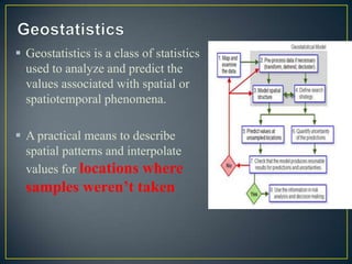
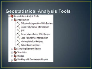
This document introduces geoprocessing in ArcGIS using Python scripts, highlighting its purpose in managing geographic data and performing various GIS analyses. It discusses the use of the 'arcpy' module, details on creating script tools, and various functions for handling user input and geoprocessing messages. Additionally, it covers geostatistical analysis, including parameter definitions and methods for predicting values associated with spatial phenomena.


![[FOSS4G Seoul 2015] New Geoprocessing Toolbox in uDig Desktop GIS](https://cdn.slidesharecdn.com/ss_thumbnails/foss4g2015newgeoprocessingtoolboxinudigdesktopapplicationframework-150917042904-lva1-app6892-thumbnail.jpg?width=640&height=640&fit=bounds)


![Using arc map to create package map along with a report file [metadata]](https://cdn.slidesharecdn.com/ss_thumbnails/usingarcmaptocreatepackagemapalongwithareportfilemetadata-140430025951-phpapp02-thumbnail.jpg?width=640&height=640&fit=bounds)


