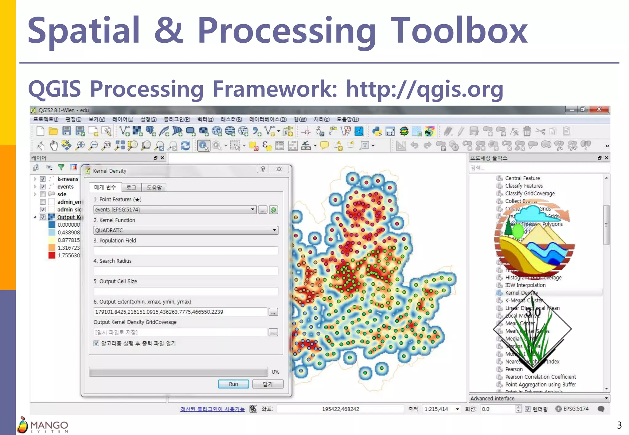
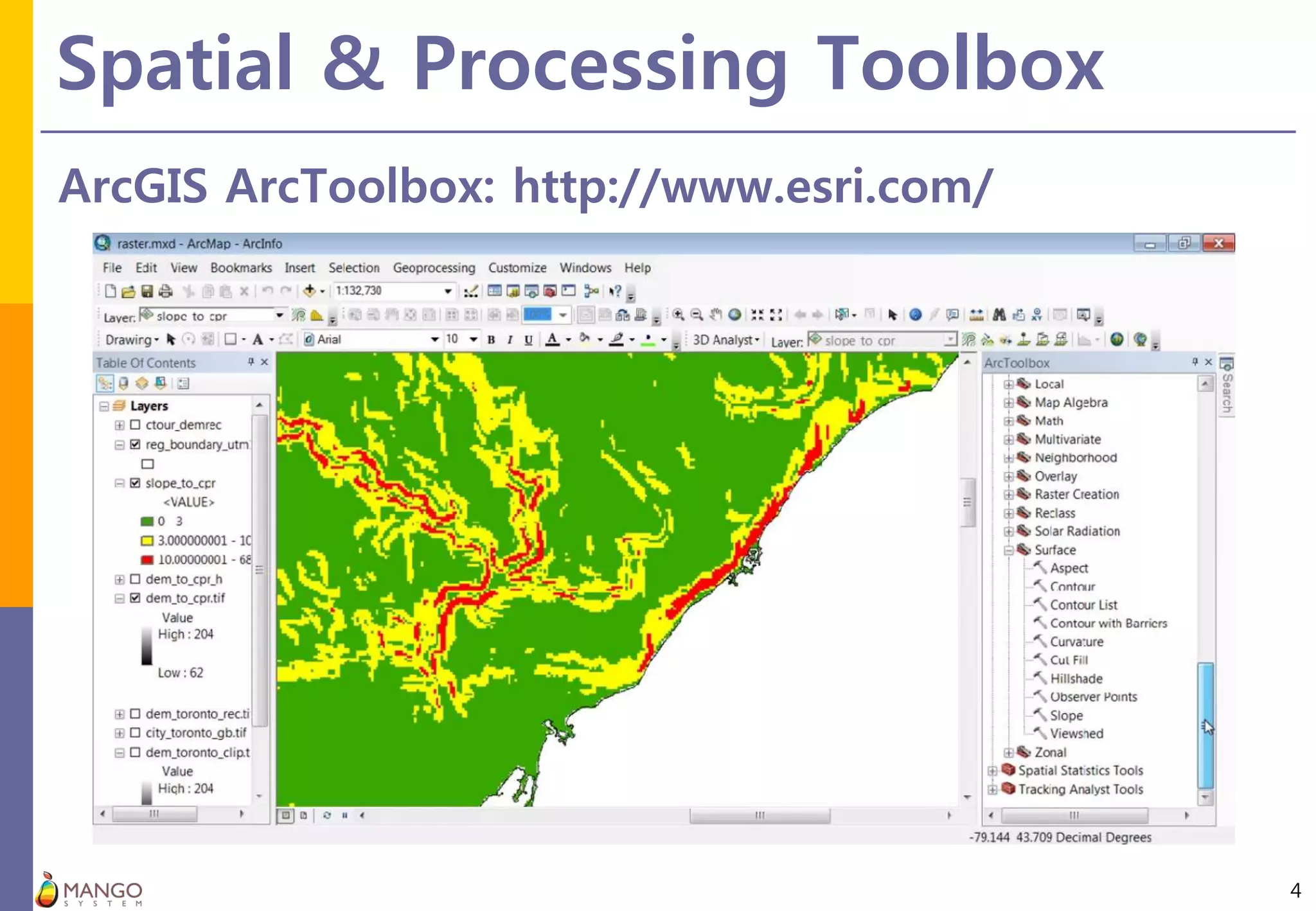
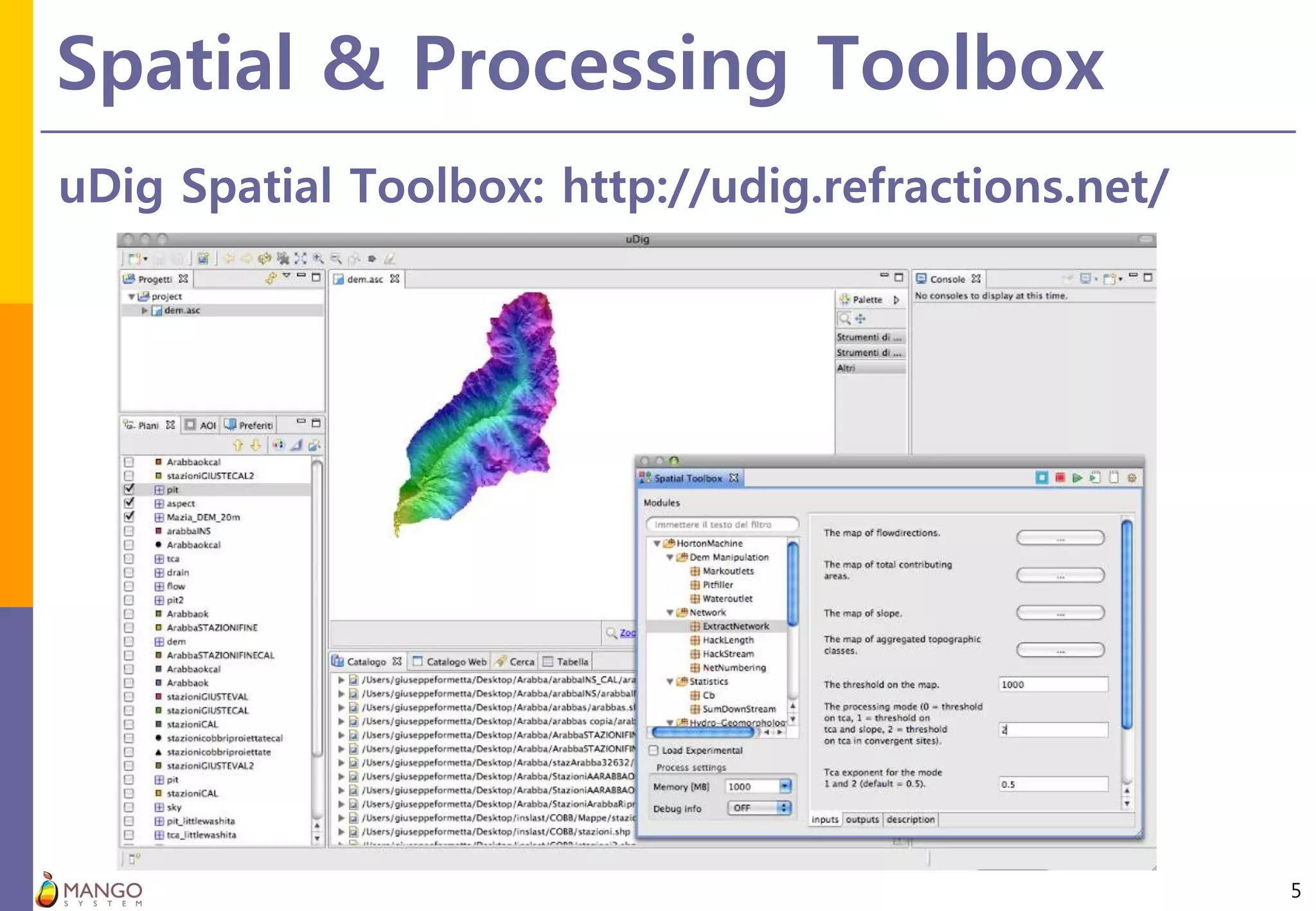
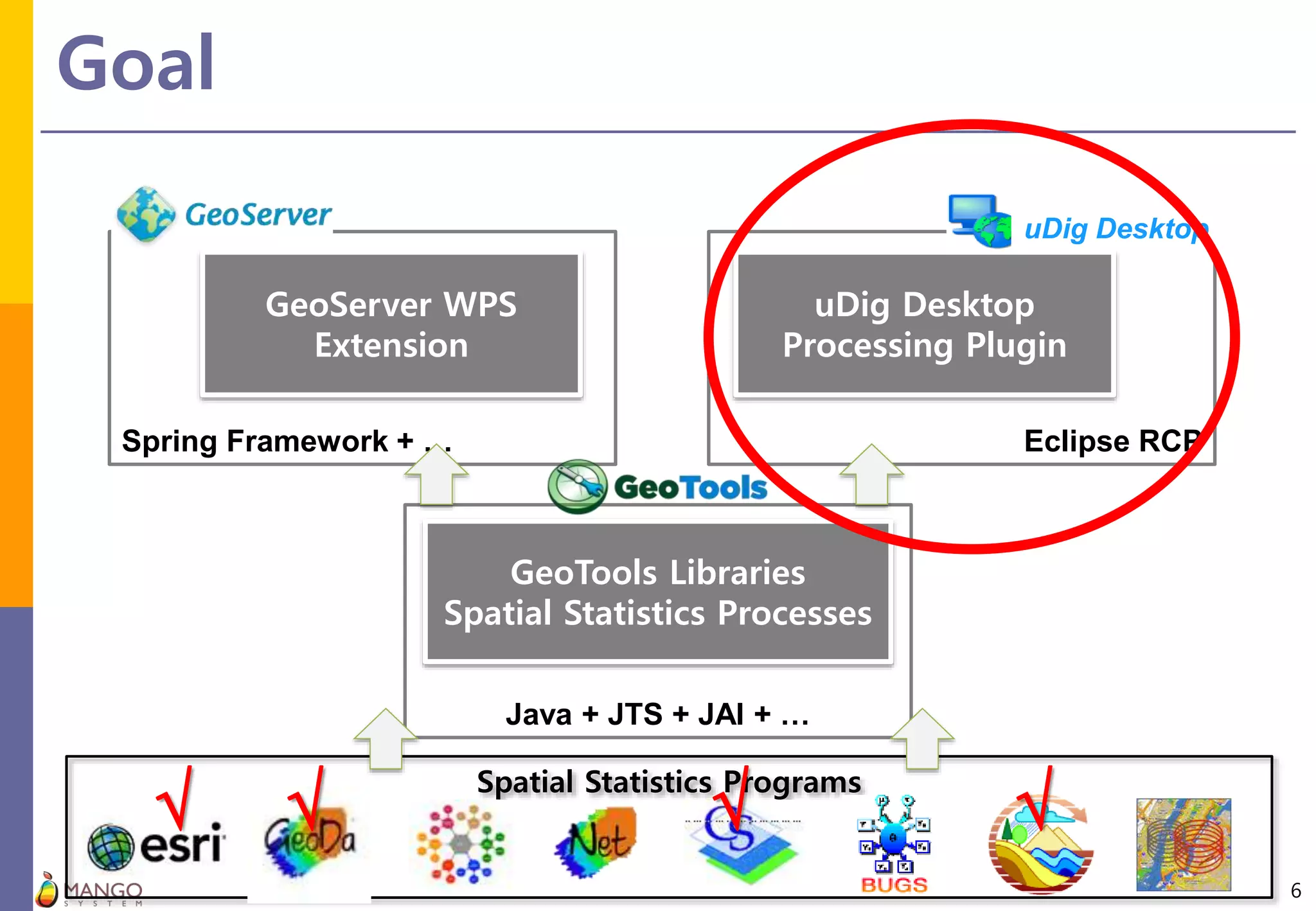
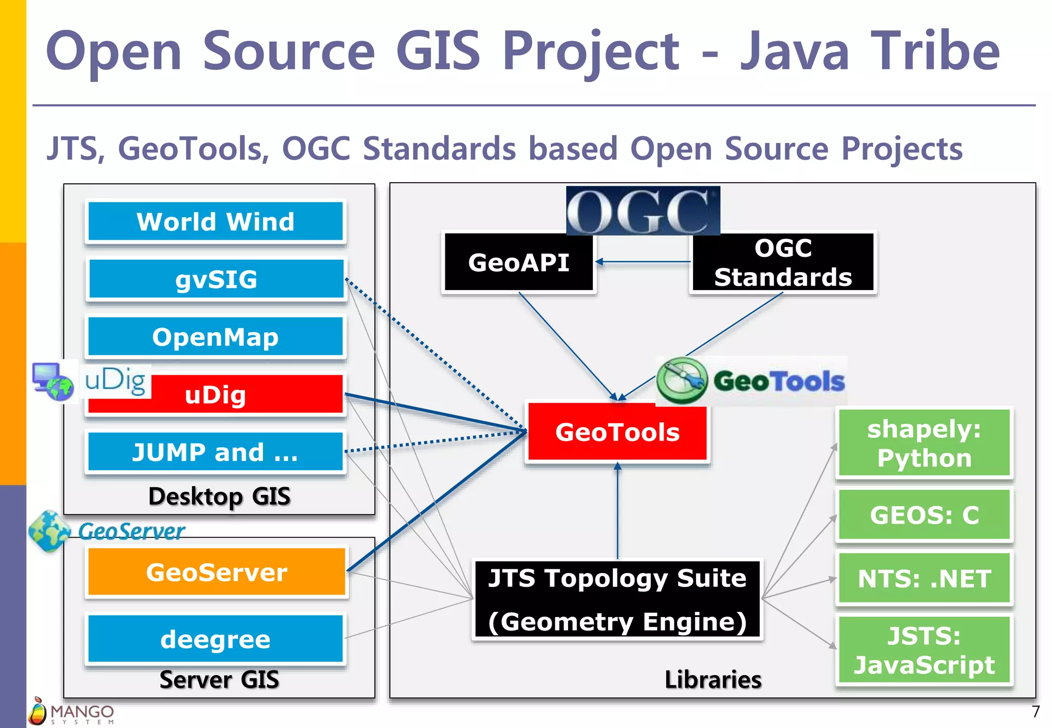
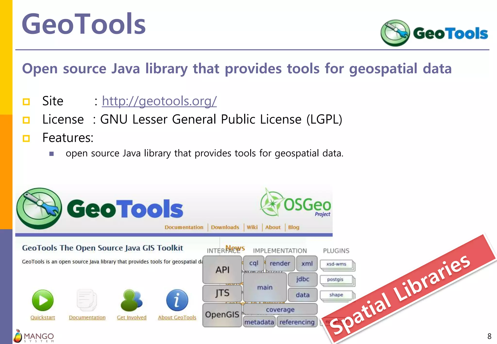
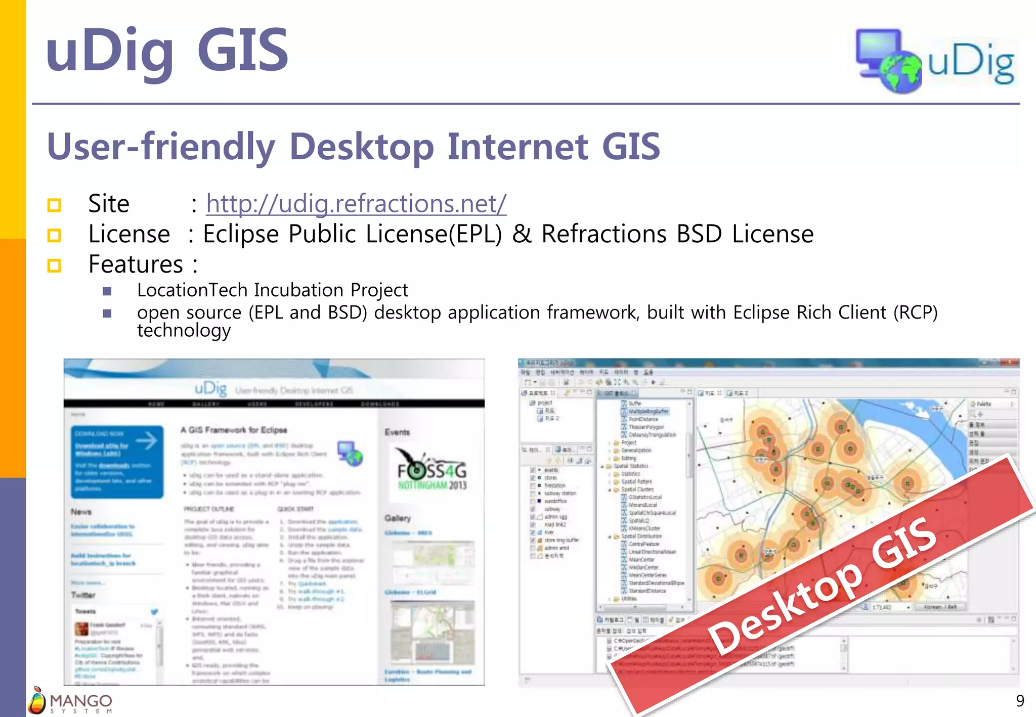
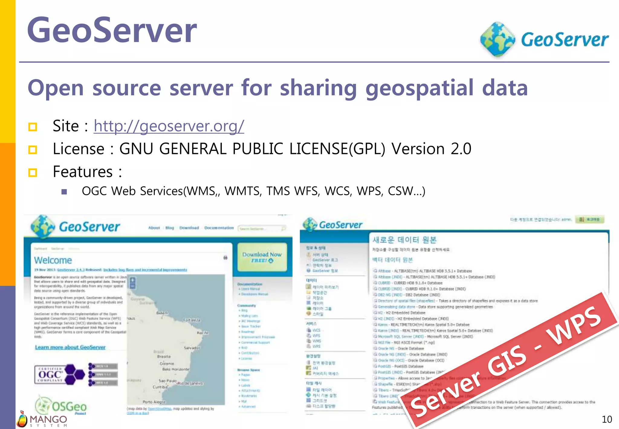
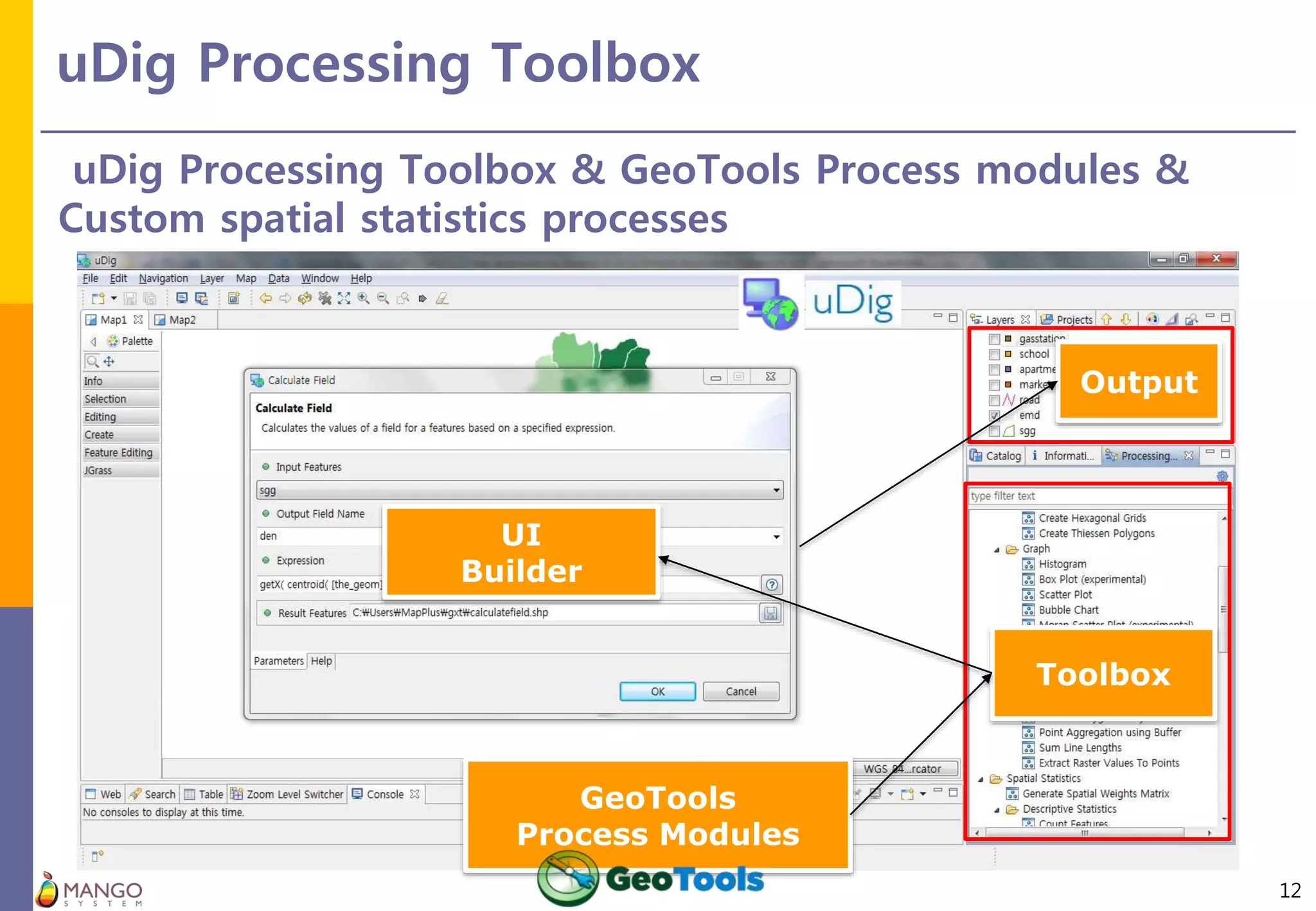
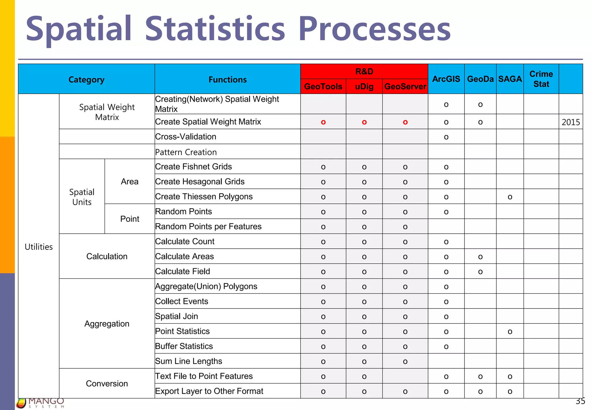
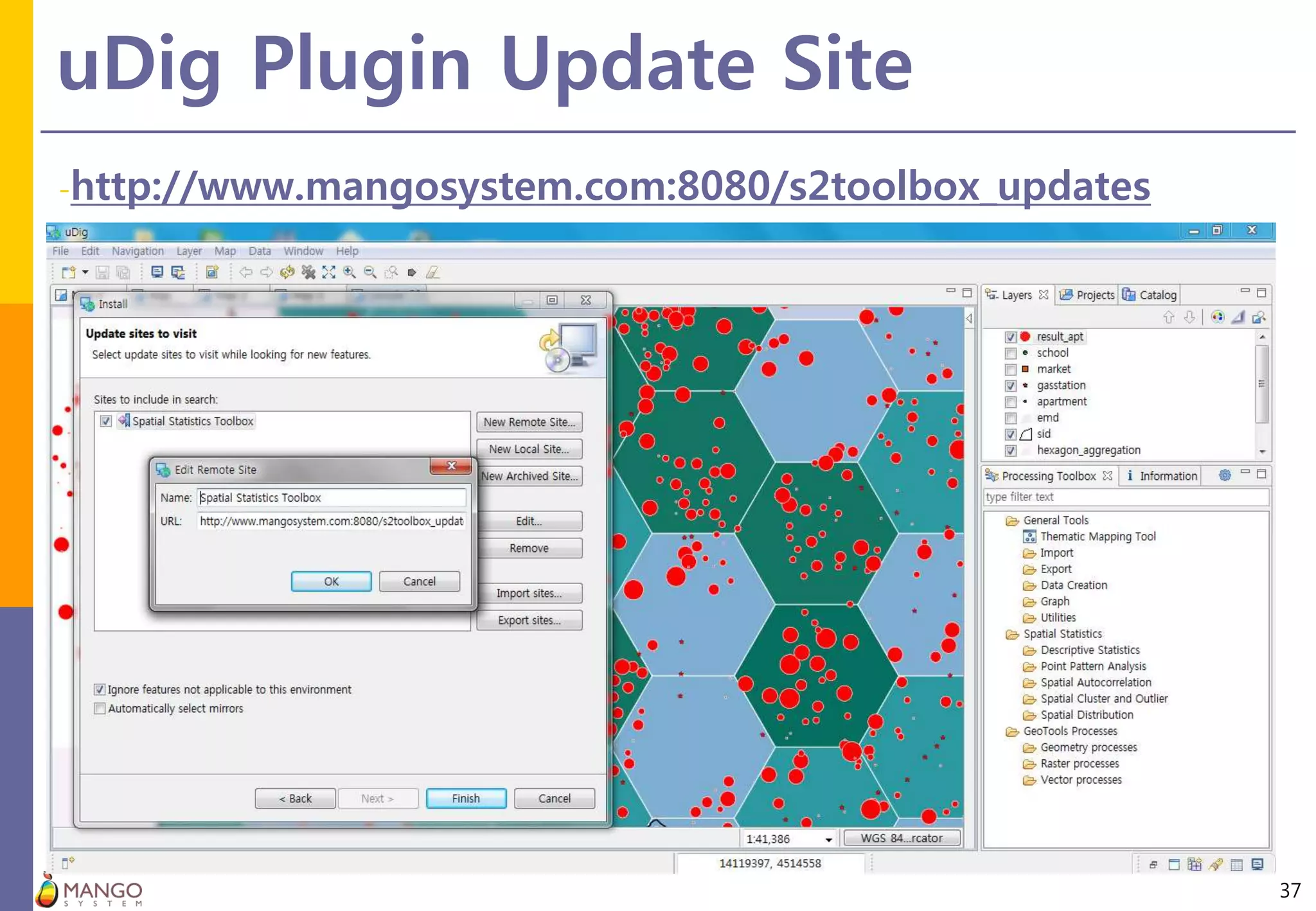
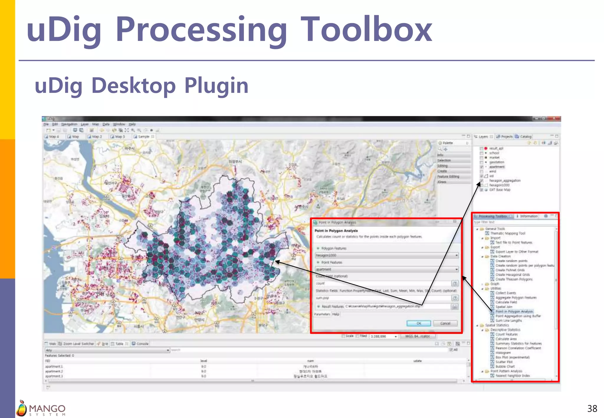
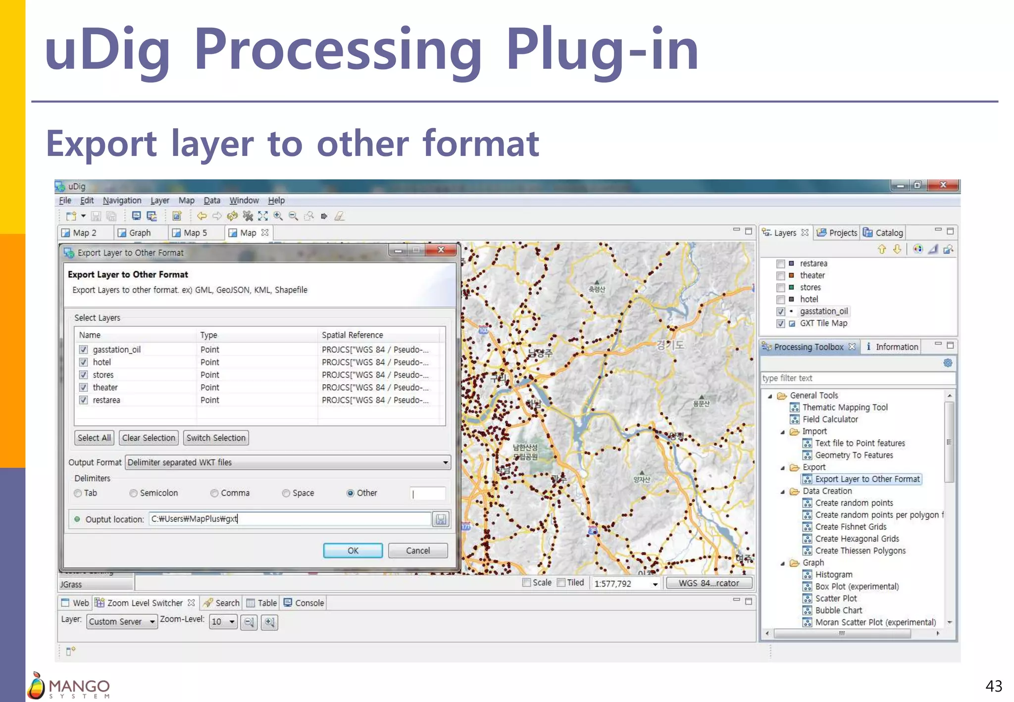
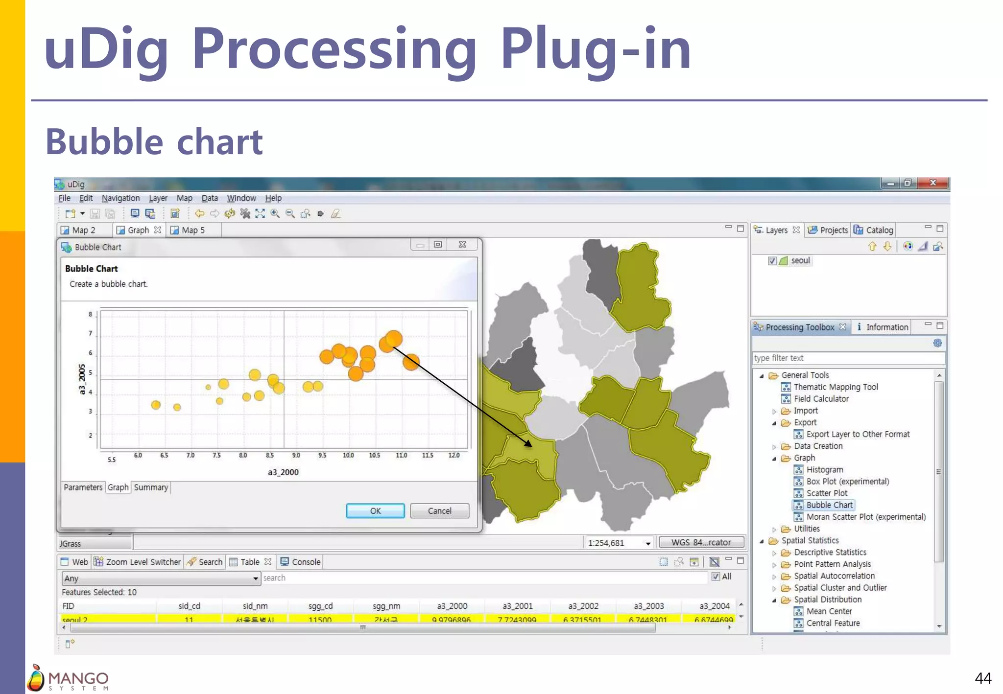
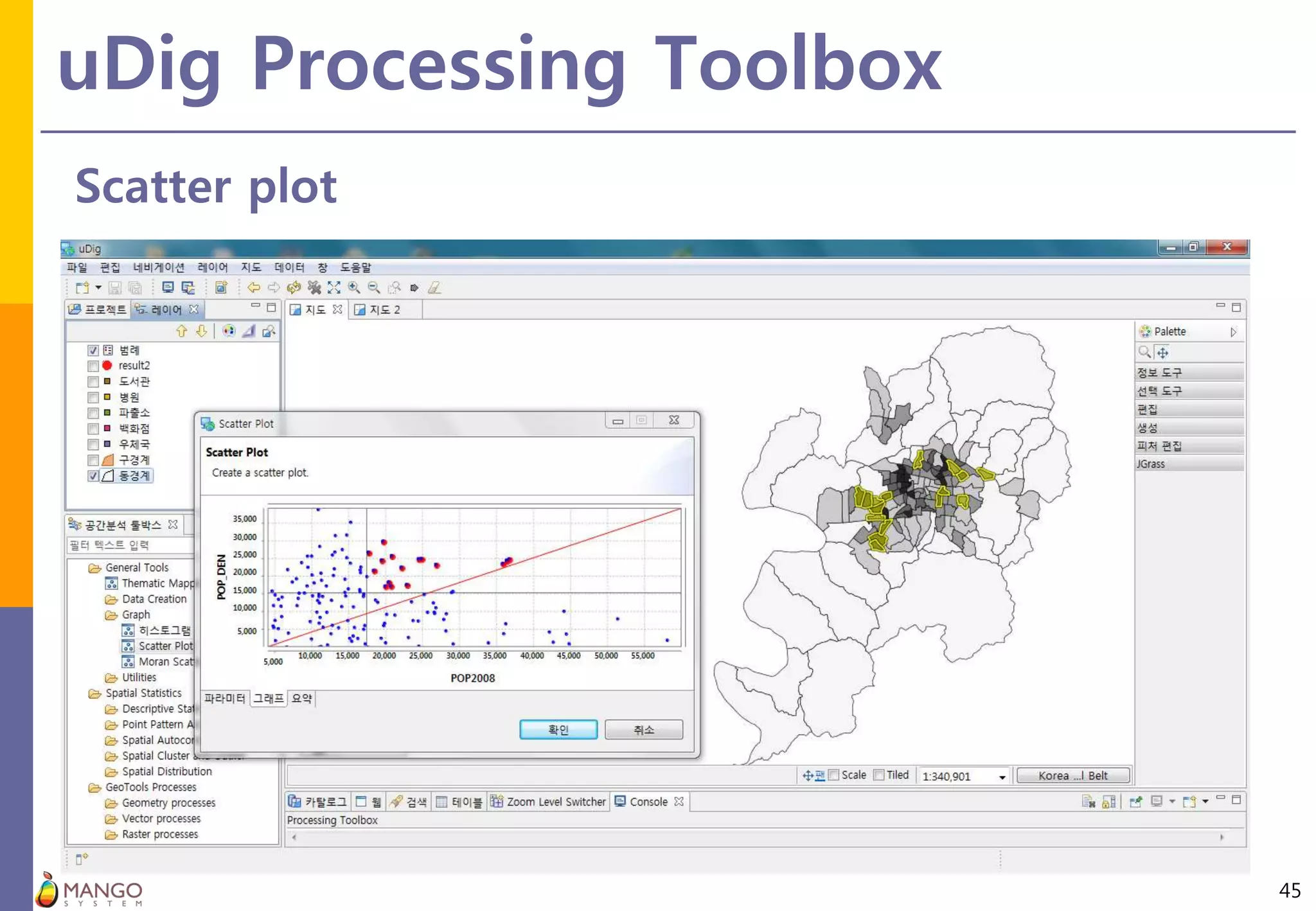
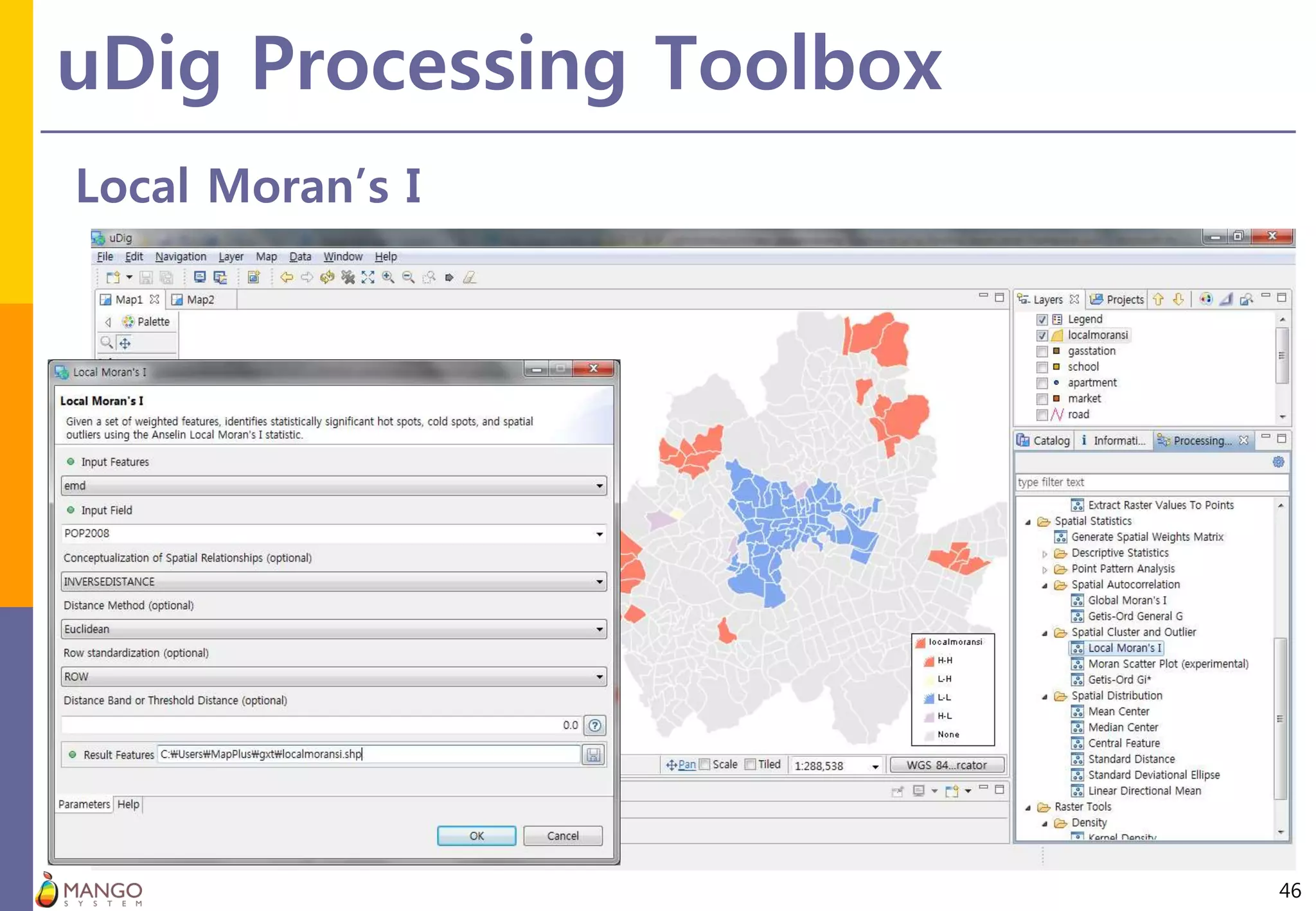
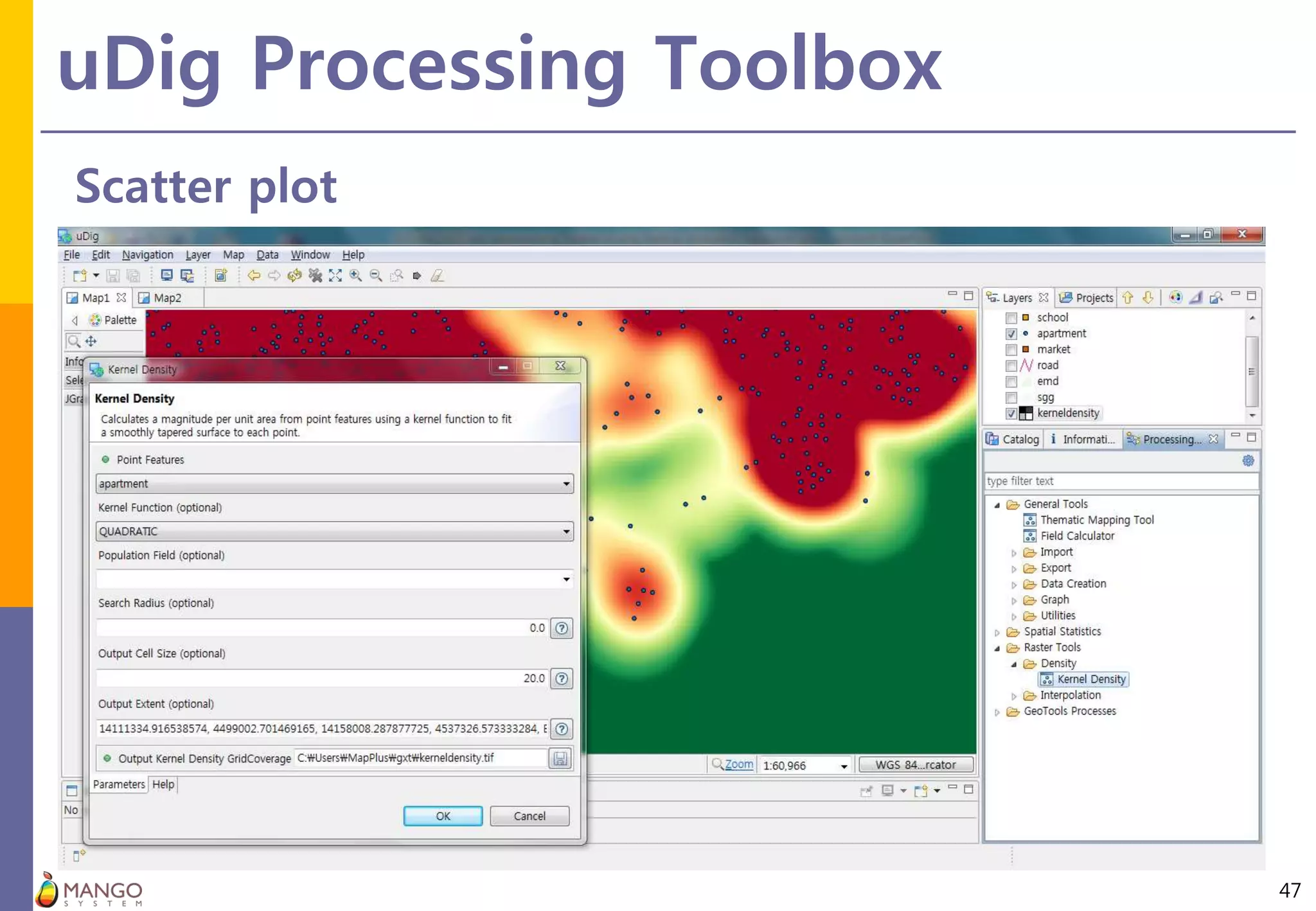
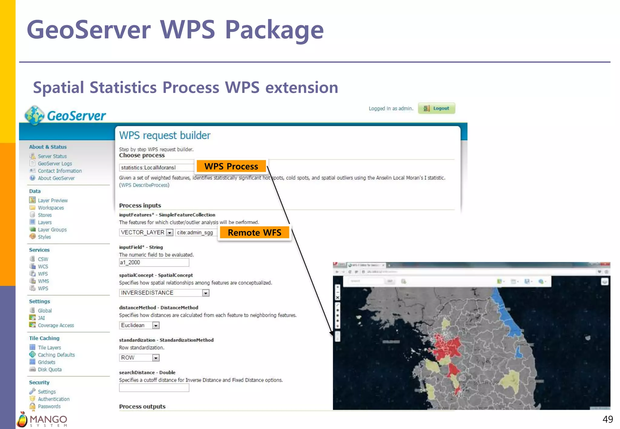
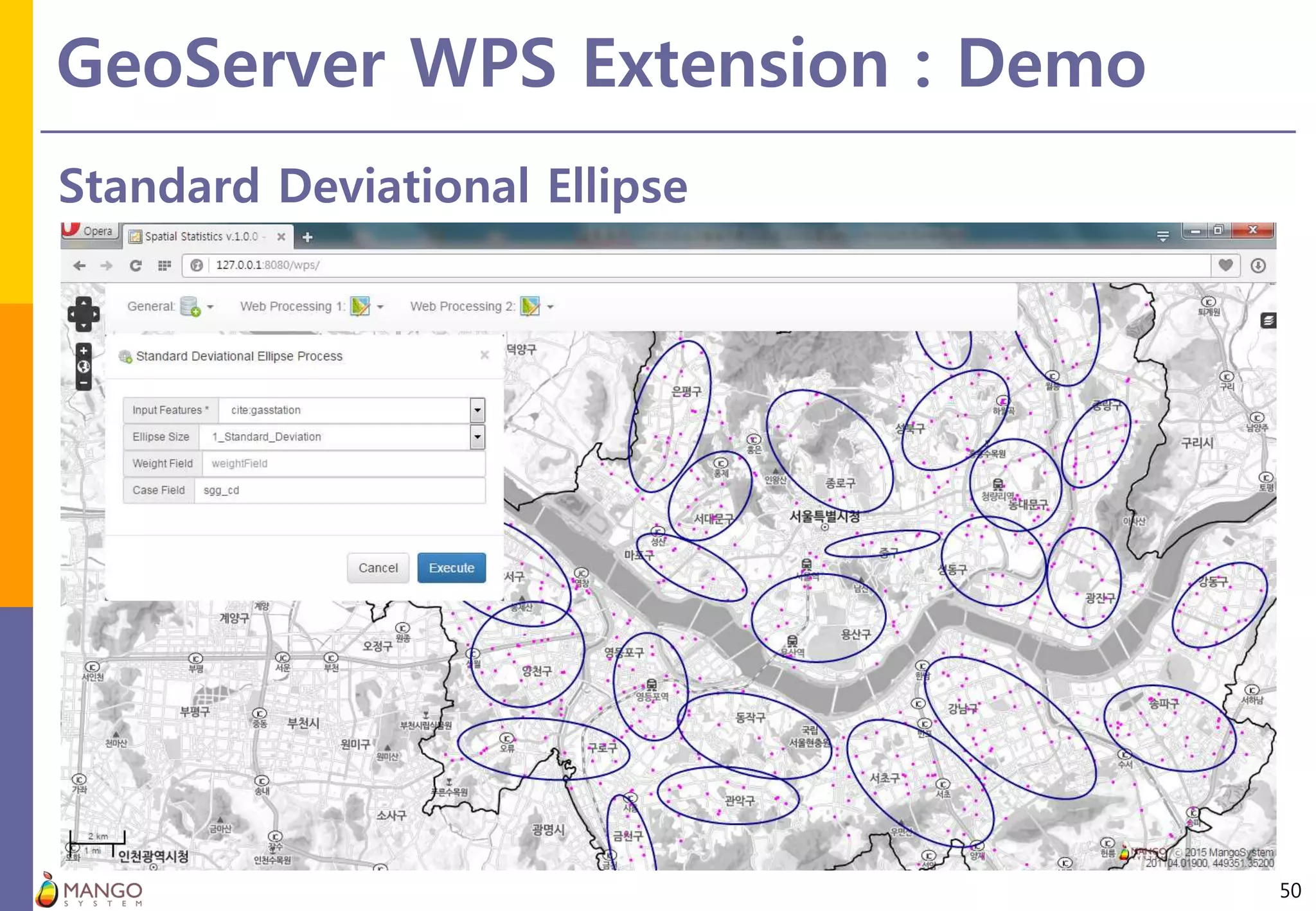
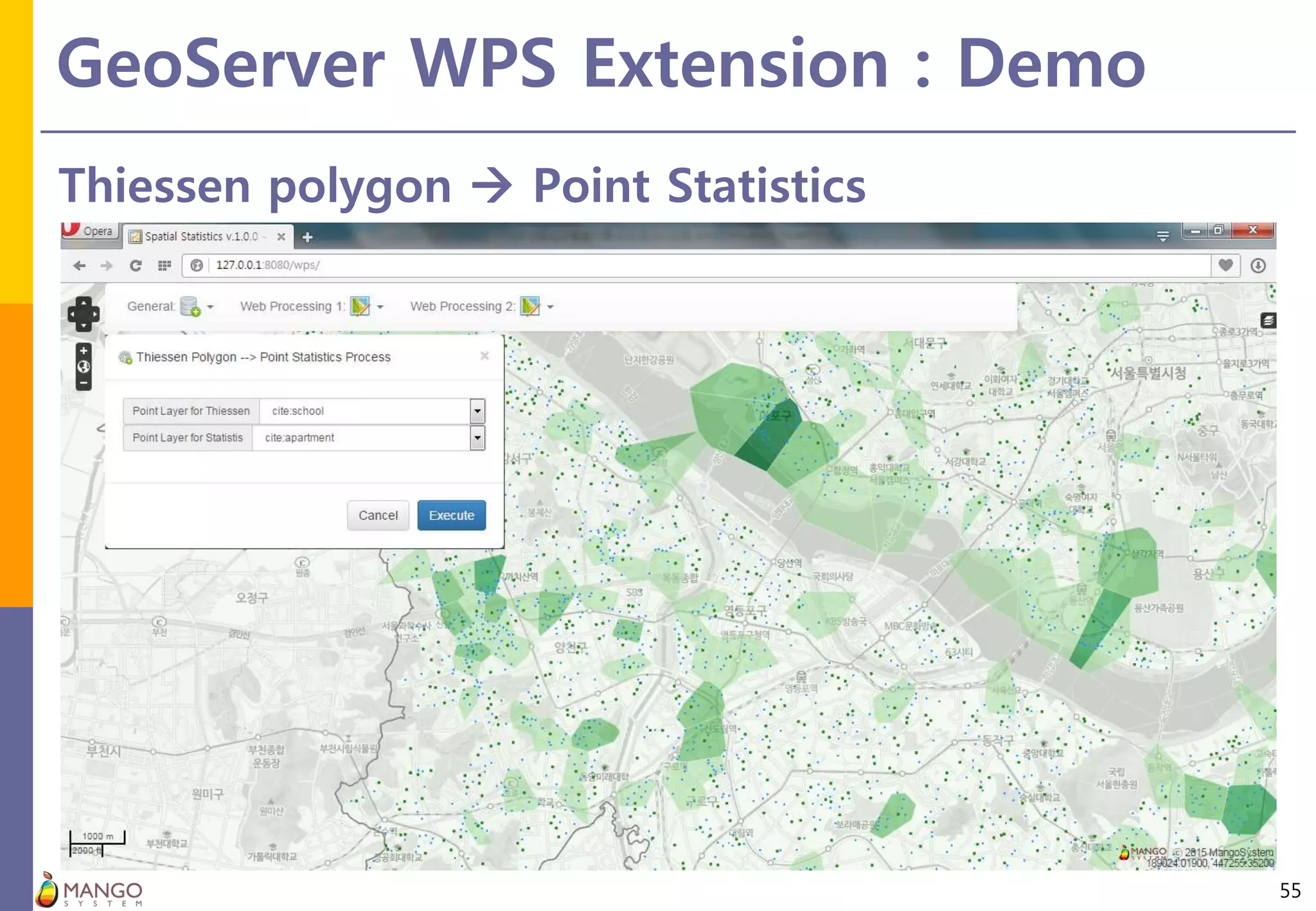
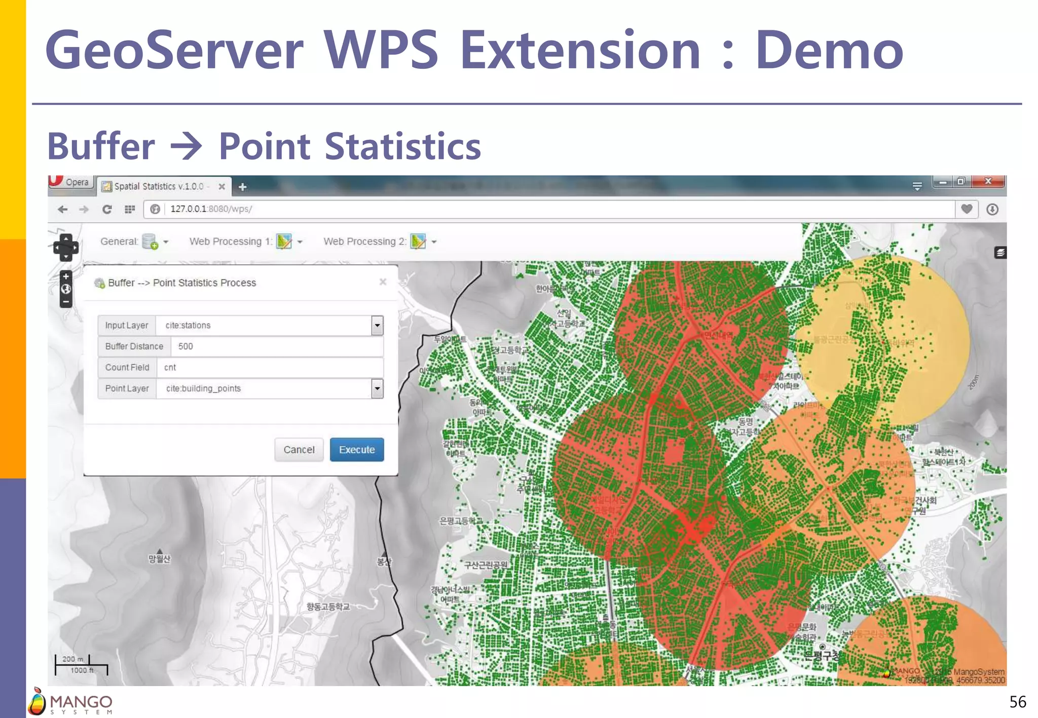
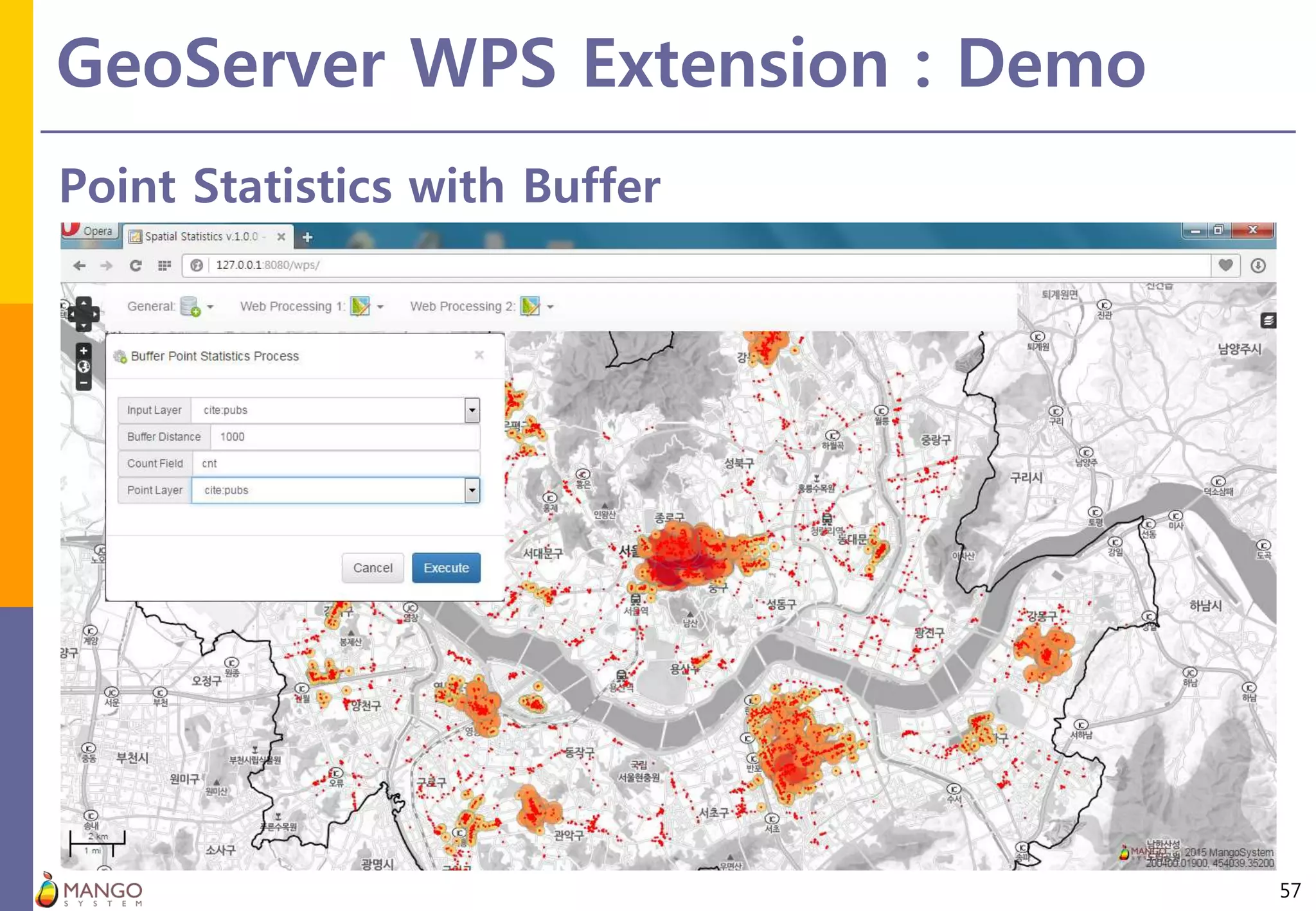
New Geoprocessing Toolbox
in uDig Desktop Application
Minpa Lee (Mango System inc.)
KiWoong Kim(Mango System inc.)
FOSS4G Seoul 2015
2015.09.16
OVERVIEW
2
Spatial & Processing Toolbox
3
QGIS Processing Framework: http://qgis.org
Spatial & Processing Toolbox
4
ArcGIS ArcToolbox: http://www.esri.com/
Spatial & Processing Toolbox
5
uDig Spatial Toolbox: http://udig.refractions.net/
Eclipse RCPSpring Framework + …
Goal
6
GeoTools Libraries
Spatial Statistics Processes
GeoServer WPS
Extension
uDig Desktop
Processing Plugin
uDig Desktop
Java + JTS + JAI + …
Spatial Statistics Programs
   
Open Source GIS Project - Java Tribe
7
JTS, GeoTools, OGC Standards based Open Source Projects
LibrariesServer GIS
Desktop GIS
GeoTools
OpenMap
GeoServer JTS Topology Suite
(Geometry Engine)
JUMP and …
uDig
deegree
gvSIG
GeoAPI
OGC
Standards
GEOS: C
NTS: .NET
JSTS:
JavaScript
World Wind
shapely:
Python
GeoTools
8
Open source Java library that provides tools for geospatial data
 Site : http://geotools.org/
 License : GNU Lesser General Public License (LGPL)
 Features:
 open source Java library that provides tools for geospatial data.
uDig GIS
9
User-friendly Desktop Internet GIS
 Site : http://udig.refractions.net/
 License : Eclipse Public License(EPL) & Refractions BSD License
 Features :
 LocationTech Incubation Project
 open source (EPL and BSD) desktop application framework, built with Eclipse Rich Client (RCP)
technology
GeoServer
10
Open source server for sharing geospatial data
 Site : http://geoserver.org/
 License : GNU GENERAL PUBLIC LICENSE(GPL) Version 2.0
 Features :
 OGC Web Services(WMS,, WMTS, TMS WFS, WCS, WPS, CSW…)
PARAMETERS &
USER INTERFACE
11
uDig Processing Toolbox
12
uDig Processing Toolbox & GeoTools Process modules &
Custom spatial statistics processes
GeoTools
Process Modules
Toolbox
UI
Builder
Output
uDig Processing Toolbox
13
Toolbox - Parameter Tab
 I18N support and various widgets & actions in parameter tab
uDig Processing Toolbox
14
Toolbox - Help Tab
English Korean
Input parameters
15
Input parameters and User Interface
Parameter Type Widget Related Widget & Popup Constraints
BoundingBoxData BoundingBox Text + Button Extent from map, layers
ComplexData
SimpleFeatureCollection Combo All, Point, Line, Polygon
GridCoverage2D Combo
Geometry Text + Button
Map’s Centroid, Extent
Geometry Picker Dialog
WKT
Filter Text+ Button Query Builder Dialog
LiteralData
CoordinateReferenceSystem Text+ Button
CRS Chooser Dialog
CRS from map, layers
EPSG:3857
Enum Combo Enum Types
Number
Float, Double Text+ Button Layer’s Area…
Short, Integer, Long Spinner
Boolean Combo Yes/No
String
Field Combo Related to vector layers
Other Text+ Button
Expression Builder Dialog
Multiple Fields Selector Dialog
Summary Fields Builder Dialog
Input parameters
16
Toolbox – Custom Widget & Dialog – Popup menu related to numeric values
 LiteralData – short, int, long
 Feature count of selected layer
Input parameters
17
Toolbox – Custom Widget & Dialog – Popup menu related to numeric values
 LiteralData – Double, Float
 Polygon layer’s area(sum)
Input parameters
18
Toolbox – Custom Widget & Dialog
 SimpleFeatureCollection & related field
Input parameters
19
Toolbox – Custom Widget & Dialog – CRS Chooser Dialog
 BoundingBoxData– BoundingBox
 minx, miny, maxx, maxy, epsg
Input parameters
20
Toolbox – Custom Widget & Dialog - Expression Builder Dialog
 LiteralData – String Type
 Filter Expression & Functions
Input parameters
21
Toolbox – Custom Widget & Dialog – Multiple Fields Selection Dialog
 LiteralData – String Type
 Comma separated fields
Input parameters
22
Toolbox – Custom Widget & Dialog – Statistics Fields Selection Dialog
 LiteralData – String Type
 String – first, last
 Numeric – sum, mean…
Input parameters
23
Toolbox – Custom Widget & Dialog – Statistics Fields Selection Dialog
 LiteralData – Java Enum Object
Input parameters
24
Toolbox – Custom Widget & Dialog – Statistics Fields Selection Dialog
 LiteralData – Boolean : Yes / No
Input parameters
25
Toolbox – Custom Widget & Dialog – Query Builder Dialog
 ComplexData – Filter
Input parameters
26
Toolbox – Custom Widget & Dialog – CRS Chooser Dialog(uDig internal)
 LiteralData– CoordinateReferenceSystem
Input parameters
27
Toolbox – Custom Widget & Dialog – Geometry Picker Dialog
 ComplexData – Geometry
Output parameters
28
HTML, Shapefile(Vector), GeoTIFF(Raster), Temporary features(Geometry)
Parameter Type Target Display Type Constraints
BoundingBoxOutput BoundingBox Map Polygon Layer Temporary
ComplexOutput
SimpleFeatureCollection Map Vector Layer
GridCoverage2D Map Raster Layer
Geometry Map Vector Layer Temporary
Custom XML Text HTML
LiteralOutput
String Text HTML
Number Text HTML Number Format(6)
Output parameters
29
Shapefile(SimpleFeatureCollection) output
Output parameters
30
Custom output
CUSTOM PROCESSES
31
Spatial Statistics Processes
32
Category Functions
R&D
ArcGIS GeoDa SAGA
Crime
Stat
GeoTools uDig GeoServer
Spatial
Aggregation
&
Distributions
Descriptive
Spatial Aggregation o o o o
Basic Statistics o o o o o
Pearson Correlation Coefficient o o o o
Standardized Scores o o o 2015
Focal Location Quotients o o o 2015
Distributions
Mean Center o o o o o
Median Center o o o o o 2015
Central Feature o o o o
Standard Distance o o o o o
Standard Deviational Ellipse o o o o
Linear Directional Mean o o o o
Density Kernel Density Estimation o o o o o o
2015
Spatial Statistics Processes
33
Category Functions
R&D
ArcGIS GeoDa SAGA
Crime
StatGeoTools uDig GeoServer
Spatial
Pattern
Analysis
Global
Point Pattern
Analysis
(k) Nearest Neighbor Statistic o o o o o
Quadrat Method
G-function
F-function
Cuzick-Edwards Test (Case-Control)
(Network) K-function o o
Local
Point Pattern
Analysis
Nearest Neighbor Hierarchical Clustering o
Zonal Nearest Neighbor Hierarchical Clustering o
Spatial and Temporal Analysis of Crime o
K-Means Clustering (Kmeans) o o o o
Global
Spatial
Auto-
correlation
Univariate
Join Count Statistic o o o
Moran’s I Statistic o o o o o o o
Oden’s I Statistic
Geary’s C Statistic o o o o
Getis-Ord’s G Statistic o o o o o
Tango’s C Statistic o o o
Rogerson’s R Statistic o o o
Bivariate Bivariate Moran’s I Statistic o o o o
Local
Spatial
Auto-
correlation
Univariate
Local Moran’s I Statistic o o o o o o
Local G Statistic o o o o o
Local Tango’s C Statistic o o o
Local Rogerson’s R Statistic o o o
Bivariate Local Bivariate Moran’s I Statistic o o o o
Local
Spatial Clustering
Openshaw’s GAM
AMOEBA o o o
Kulldorff’s Spatial Scan Statistic
New
Algorithms
Spatial Statistics Processes
34
Category Functions
R&D
ArcGIS GeoDa SAGA
Crime
StatGeoTools uDig GeoServer
(Spatial)
Regression
Standardized Standardized regression o o
Global
Spatial Lag Model (SLM) o o
Spatial Error Model (SEM) o o
Local
Geographically Weighted Regression
(GWR)
o o
Expansion Method
Spatial
Interpolation
Deterministic
IDW (Inverse Distance Weighted) o o o o o
Spline o o
Geostatistical (Co) Kriging o o
Visualization
Analysis
Tools
Graph
Moran Scatter Plot o o
Histogram o o o
Box Plot(Box and Whisker) o o o
Scatter Plot o o o
Bubble Chart o o o
3D Scatter Plot o
Conditional Map o
Conditional Scatter Plot o
Conditional Histogram o
Parallel Coordinate o
Covariance Cloud o
Semivariogram o o
Correlagram o
Visualization
Standard Graphic Tools o o
Thematic Map o o o o
Graph
Tools
Spatial Statistics Processes
35
Category Functions
R&D
ArcGIS GeoDa SAGA
Crime
StatGeoTools uDig GeoServer
Utilities
Spatial Weight
Matrix
Creating(Network) Spatial Weight
Matrix
o o
Create Spatial Weight Matrix o o o o o 2015
Cross-Validation o
Pattern Creation
Spatial
Units
Area
Create Fishnet Grids o o o o
Create Hesagonal Grids o o o o
Create Thiessen Polygons o o o o o
Point
Random Points o o o o
Random Points per Features o o o
Calculation
Calculate Count o o o o
Calculate Areas o o o o o
Calculate Field o o o o o
Aggregation
Aggregate(Union) Polygons o o o o
Collect Events o o o o
Spatial Join o o o o
Point Statistics o o o o o
Buffer Statistics o o o o
Sum Line Lengths o o o
Conversion
Text File to Point Features o o o o o
Export Layer to Other Format o o o o o o
DEMO
36
uDig Plugin Update Site
37
-http://www.mangosystem.com:8080/s2toolbox_updates
uDig Processing Toolbox
38
uDig Desktop Plugin
uDig Processing Toolbox
39
GeoTools Processes
uDig Processing Toolbox
40
Thematic Mapping Tool
uDig Processing Toolbox
41
Thiessen Polygons
uDig Processing Toolbox
42
Text file to point features
uDig Processing Plug-in
43
Export layer to other format
uDig Processing Plug-in
44
Bubble chart
uDig Processing Toolbox
45
Scatter plot
uDig Processing Toolbox
46
Local Moran’s I
uDig Processing Toolbox
47
Scatter plot
GEOSERVER WPS
48
GeoServer WPS Package
49
Spatial Statistics Process WPS extension
WPS Process
Remote WFS
GeoServer WPS Extension : Demo
50
Standard Deviational Ellipse
GeoServer WPS Extension : Demo
51
Local Moran’s I
GeoServer WPS Extension : Demo
52
Point in Polygon
GeoServer WPS Extension : Demo
53
Hexagonal Grids  Point Statistics  Local Moran’s I
GeoServer WPS Extension : Demo
54
Sum Line Length
GeoServer WPS Extension : Demo
55
Thiessen polygon  Point Statistics
GeoServer WPS Extension : Demo
56
Buffer  Point Statistics
GeoServer WPS Extension : Demo
57
Point Statistics with Buffer
HOW TO JOIN
58
Source Code: Github
59
https://github.com/mapplus/spatial_statistics_for_geotools_udig
Deployment: SourceForge
60
https://sourceforge.net/projects/mango-spatialstatistics
Localization: Transifex
61
https://www.transifex.com/projects/p/ss-rd/
English
Korean
…
Thanks!
Minpa Lee : mapplus@gmail.com
Jooyong Park : jya1210@gmail.com
KiWoong Kim : socoooooool@gmail.com

[FOSS4G Seoul 2015] New Geoprocessing Toolbox in uDig Desktop GIS

  • 1.
    New Geoprocessing Toolbox inuDig Desktop Application Minpa Lee (Mango System inc.) KiWoong Kim(Mango System inc.) FOSS4G Seoul 2015 2015.09.16
  • 2.
  • 3.
    Spatial & ProcessingToolbox 3 QGIS Processing Framework: http://qgis.org
  • 4.
    Spatial & ProcessingToolbox 4 ArcGIS ArcToolbox: http://www.esri.com/
  • 5.
    Spatial & ProcessingToolbox 5 uDig Spatial Toolbox: http://udig.refractions.net/
  • 6.
    Eclipse RCPSpring Framework+ … Goal 6 GeoTools Libraries Spatial Statistics Processes GeoServer WPS Extension uDig Desktop Processing Plugin uDig Desktop Java + JTS + JAI + … Spatial Statistics Programs    
  • 7.
    Open Source GISProject - Java Tribe 7 JTS, GeoTools, OGC Standards based Open Source Projects LibrariesServer GIS Desktop GIS GeoTools OpenMap GeoServer JTS Topology Suite (Geometry Engine) JUMP and … uDig deegree gvSIG GeoAPI OGC Standards GEOS: C NTS: .NET JSTS: JavaScript World Wind shapely: Python
  • 8.
    GeoTools 8 Open source Javalibrary that provides tools for geospatial data  Site : http://geotools.org/  License : GNU Lesser General Public License (LGPL)  Features:  open source Java library that provides tools for geospatial data.
  • 9.
    uDig GIS 9 User-friendly DesktopInternet GIS  Site : http://udig.refractions.net/  License : Eclipse Public License(EPL) & Refractions BSD License  Features :  LocationTech Incubation Project  open source (EPL and BSD) desktop application framework, built with Eclipse Rich Client (RCP) technology
  • 10.
    GeoServer 10 Open source serverfor sharing geospatial data  Site : http://geoserver.org/  License : GNU GENERAL PUBLIC LICENSE(GPL) Version 2.0  Features :  OGC Web Services(WMS,, WMTS, TMS WFS, WCS, WPS, CSW…)
  • 11.
  • 12.
    uDig Processing Toolbox 12 uDigProcessing Toolbox & GeoTools Process modules & Custom spatial statistics processes GeoTools Process Modules Toolbox UI Builder Output
  • 13.
    uDig Processing Toolbox 13 Toolbox- Parameter Tab  I18N support and various widgets & actions in parameter tab
  • 14.
    uDig Processing Toolbox 14 Toolbox- Help Tab English Korean
  • 15.
    Input parameters 15 Input parametersand User Interface Parameter Type Widget Related Widget & Popup Constraints BoundingBoxData BoundingBox Text + Button Extent from map, layers ComplexData SimpleFeatureCollection Combo All, Point, Line, Polygon GridCoverage2D Combo Geometry Text + Button Map’s Centroid, Extent Geometry Picker Dialog WKT Filter Text+ Button Query Builder Dialog LiteralData CoordinateReferenceSystem Text+ Button CRS Chooser Dialog CRS from map, layers EPSG:3857 Enum Combo Enum Types Number Float, Double Text+ Button Layer’s Area… Short, Integer, Long Spinner Boolean Combo Yes/No String Field Combo Related to vector layers Other Text+ Button Expression Builder Dialog Multiple Fields Selector Dialog Summary Fields Builder Dialog
  • 16.
    Input parameters 16 Toolbox –Custom Widget & Dialog – Popup menu related to numeric values  LiteralData – short, int, long  Feature count of selected layer
  • 17.
    Input parameters 17 Toolbox –Custom Widget & Dialog – Popup menu related to numeric values  LiteralData – Double, Float  Polygon layer’s area(sum)
  • 18.
    Input parameters 18 Toolbox –Custom Widget & Dialog  SimpleFeatureCollection & related field
  • 19.
    Input parameters 19 Toolbox –Custom Widget & Dialog – CRS Chooser Dialog  BoundingBoxData– BoundingBox  minx, miny, maxx, maxy, epsg
  • 20.
    Input parameters 20 Toolbox –Custom Widget & Dialog - Expression Builder Dialog  LiteralData – String Type  Filter Expression & Functions
  • 21.
    Input parameters 21 Toolbox –Custom Widget & Dialog – Multiple Fields Selection Dialog  LiteralData – String Type  Comma separated fields
  • 22.
    Input parameters 22 Toolbox –Custom Widget & Dialog – Statistics Fields Selection Dialog  LiteralData – String Type  String – first, last  Numeric – sum, mean…
  • 23.
    Input parameters 23 Toolbox –Custom Widget & Dialog – Statistics Fields Selection Dialog  LiteralData – Java Enum Object
  • 24.
    Input parameters 24 Toolbox –Custom Widget & Dialog – Statistics Fields Selection Dialog  LiteralData – Boolean : Yes / No
  • 25.
    Input parameters 25 Toolbox –Custom Widget & Dialog – Query Builder Dialog  ComplexData – Filter
  • 26.
    Input parameters 26 Toolbox –Custom Widget & Dialog – CRS Chooser Dialog(uDig internal)  LiteralData– CoordinateReferenceSystem
  • 27.
    Input parameters 27 Toolbox –Custom Widget & Dialog – Geometry Picker Dialog  ComplexData – Geometry
  • 28.
    Output parameters 28 HTML, Shapefile(Vector),GeoTIFF(Raster), Temporary features(Geometry) Parameter Type Target Display Type Constraints BoundingBoxOutput BoundingBox Map Polygon Layer Temporary ComplexOutput SimpleFeatureCollection Map Vector Layer GridCoverage2D Map Raster Layer Geometry Map Vector Layer Temporary Custom XML Text HTML LiteralOutput String Text HTML Number Text HTML Number Format(6)
  • 29.
  • 30.
  • 31.
  • 32.
    Spatial Statistics Processes 32 CategoryFunctions R&D ArcGIS GeoDa SAGA Crime Stat GeoTools uDig GeoServer Spatial Aggregation & Distributions Descriptive Spatial Aggregation o o o o Basic Statistics o o o o o Pearson Correlation Coefficient o o o o Standardized Scores o o o 2015 Focal Location Quotients o o o 2015 Distributions Mean Center o o o o o Median Center o o o o o 2015 Central Feature o o o o Standard Distance o o o o o Standard Deviational Ellipse o o o o Linear Directional Mean o o o o Density Kernel Density Estimation o o o o o o 2015
  • 33.
    Spatial Statistics Processes 33 CategoryFunctions R&D ArcGIS GeoDa SAGA Crime StatGeoTools uDig GeoServer Spatial Pattern Analysis Global Point Pattern Analysis (k) Nearest Neighbor Statistic o o o o o Quadrat Method G-function F-function Cuzick-Edwards Test (Case-Control) (Network) K-function o o Local Point Pattern Analysis Nearest Neighbor Hierarchical Clustering o Zonal Nearest Neighbor Hierarchical Clustering o Spatial and Temporal Analysis of Crime o K-Means Clustering (Kmeans) o o o o Global Spatial Auto- correlation Univariate Join Count Statistic o o o Moran’s I Statistic o o o o o o o Oden’s I Statistic Geary’s C Statistic o o o o Getis-Ord’s G Statistic o o o o o Tango’s C Statistic o o o Rogerson’s R Statistic o o o Bivariate Bivariate Moran’s I Statistic o o o o Local Spatial Auto- correlation Univariate Local Moran’s I Statistic o o o o o o Local G Statistic o o o o o Local Tango’s C Statistic o o o Local Rogerson’s R Statistic o o o Bivariate Local Bivariate Moran’s I Statistic o o o o Local Spatial Clustering Openshaw’s GAM AMOEBA o o o Kulldorff’s Spatial Scan Statistic New Algorithms
  • 34.
    Spatial Statistics Processes 34 CategoryFunctions R&D ArcGIS GeoDa SAGA Crime StatGeoTools uDig GeoServer (Spatial) Regression Standardized Standardized regression o o Global Spatial Lag Model (SLM) o o Spatial Error Model (SEM) o o Local Geographically Weighted Regression (GWR) o o Expansion Method Spatial Interpolation Deterministic IDW (Inverse Distance Weighted) o o o o o Spline o o Geostatistical (Co) Kriging o o Visualization Analysis Tools Graph Moran Scatter Plot o o Histogram o o o Box Plot(Box and Whisker) o o o Scatter Plot o o o Bubble Chart o o o 3D Scatter Plot o Conditional Map o Conditional Scatter Plot o Conditional Histogram o Parallel Coordinate o Covariance Cloud o Semivariogram o o Correlagram o Visualization Standard Graphic Tools o o Thematic Map o o o o Graph Tools
  • 35.
    Spatial Statistics Processes 35 CategoryFunctions R&D ArcGIS GeoDa SAGA Crime StatGeoTools uDig GeoServer Utilities Spatial Weight Matrix Creating(Network) Spatial Weight Matrix o o Create Spatial Weight Matrix o o o o o 2015 Cross-Validation o Pattern Creation Spatial Units Area Create Fishnet Grids o o o o Create Hesagonal Grids o o o o Create Thiessen Polygons o o o o o Point Random Points o o o o Random Points per Features o o o Calculation Calculate Count o o o o Calculate Areas o o o o o Calculate Field o o o o o Aggregation Aggregate(Union) Polygons o o o o Collect Events o o o o Spatial Join o o o o Point Statistics o o o o o Buffer Statistics o o o o Sum Line Lengths o o o Conversion Text File to Point Features o o o o o Export Layer to Other Format o o o o o o
  • 36.
  • 37.
    uDig Plugin UpdateSite 37 -http://www.mangosystem.com:8080/s2toolbox_updates
  • 38.
  • 39.
  • 40.
  • 41.
  • 42.
    uDig Processing Toolbox 42 Textfile to point features
  • 43.
    uDig Processing Plug-in 43 Exportlayer to other format
  • 44.
  • 45.
  • 46.
  • 47.
  • 48.
  • 49.
    GeoServer WPS Package 49 SpatialStatistics Process WPS extension WPS Process Remote WFS
  • 50.
    GeoServer WPS Extension: Demo 50 Standard Deviational Ellipse
  • 51.
    GeoServer WPS Extension: Demo 51 Local Moran’s I
  • 52.
    GeoServer WPS Extension: Demo 52 Point in Polygon
  • 53.
    GeoServer WPS Extension: Demo 53 Hexagonal Grids  Point Statistics  Local Moran’s I
  • 54.
    GeoServer WPS Extension: Demo 54 Sum Line Length
  • 55.
    GeoServer WPS Extension: Demo 55 Thiessen polygon  Point Statistics
  • 56.
    GeoServer WPS Extension: Demo 56 Buffer  Point Statistics
  • 57.
    GeoServer WPS Extension: Demo 57 Point Statistics with Buffer
  • 58.
  • 59.
  • 60.
  • 61.
  • 62.
    Thanks! Minpa Lee :mapplus@gmail.com Jooyong Park : jya1210@gmail.com KiWoong Kim : socoooooool@gmail.com