Gabriele Candela_Image-based 3d reconstruction of a bamboo-steel spatial truss structure
•
1 like•137 views

This document summarizes a study that used a mini unmanned aerial vehicle (UAV) to perform image-based 3D reconstruction of a bamboo-steel spatial truss structure located at Nanjing Tech University in China. The UAV collected over 450 images that were processed using structure from motion algorithms to generate a dense point cloud with over 3 million points and a 3D mesh model of the truss. Measurements taken from the 3D reconstruction matched closely with real-world dimensions, demonstrating the effectiveness of using a low-cost UAV and photogrammetry techniques for surveying and creating digital models of large structures.

Recommended
More Related Content
What's hot
What's hot (20)
Similar to Gabriele Candela_Image-based 3d reconstruction of a bamboo-steel spatial truss structure
Similar to Gabriele Candela_Image-based 3d reconstruction of a bamboo-steel spatial truss structure (20)
More from International Bamboo and Rattan Organisation
More from International Bamboo and Rattan Organisation (20)
Recently uploaded
Recently uploaded (20)
Gabriele Candela_Image-based 3d reconstruction of a bamboo-steel spatial truss structure
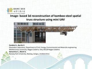
- 1. Image- based 3d reconstruction of bamboo-steel spatial truss structure using mini UAV Candela G., Barrile V. Geomatics Laboratory, Department of Civil, Energy, Environmental and Materials engineering Mediterranea University, Reggio Calabria, Italy, 89128 Reggio Calabria Demartino C., Monti G. Nanjing Tech University, Nanjing, Jiangsu, 211816 China
- 2. 2/11 1 | Structure overview Located in Nanjing Tech University, College of Civil Engineering Ø Spatial truss for roof system Ø Structural materials: Bamboo (GluBam) and steel Ø Built in 2016
- 3. 3/11 1 | Structure overview Bamboo-steel spatial truss Front view Left view
- 4. 4/11 Truss module: 1 | Structure overview Bamboo-steel spatial truss Cross-section:
- 5. 5/11 2 | Survey techniques and aerial survey 3d survey techniques: aerial survey UAV model: • Dji Mavic Pro • Satellite Positioning Systems: GPS/Glonass • Weight: 734 gr • Flight time: 27 min • Sensor: CMOS • Effective pixels: 12.35 M • 3 axis gimbal • Cost = 1500 € (13.000 Yuan) Aero-photogrammetry: Structure from Motion (SFM) algorithm • Camera poses estimation from images and camera characteristics • Scene reconstruction through «point cloud» Main advantages: + Cheap and fast methodology + Extraction of geometrial characteristics + Photographic dataset for inspections
- 6. 6/11 Dataset: Photos: 459 Dataset GB: 2,5 gb Image resolution: 4000*3000 Camera settings: 1/23’’ CMOS GPS coordinate: yes Survey time: 30 minutes 3 | Aerial survey of Bamboo spatial truss structure Methodology and workflow Ø Ground Sampling Distance calculation (for images): 0,31 cm/pixel Ø Set of flight acquisition plan: 80% overlap both vertical and horizontal
- 7. 7/11 Ø Image acquisition through UAV Ø Sparse point cloud construction Ø Dense point cloud construction Ø Noise reduction, dense point cloud cleaning Sparse point cloud: 34.500 points Running time: 21 min 3 | Aerial survey of Bamboo spatial truss structure Methodology and workflow Ø Object recognition from images: Scale Invariant Feature Transform (SIFT) Ø 3d reconstruction algorithm SFM Dense point cloud: 3 million points Running time: 5h Ø Camera poses estimation
- 8. 8/11 Front view Left view Right view 3 | Aerial survey of Bamboo spatial truss structure Methodology and workflow Ø 3d mesh: 839.405 points, 1.674.921 triangles Running time: 1h
- 9. 9/11 Top view 3 | Aerial survey of Bamboo spatial truss structure Methodology and workflow Mesh to Surface: simple geometry reconstruction Extraction of geometrical features
- 10. 10/11 4 | Results and conclusions 3d reconstruction Real and reconstructed model Cross section Real = 5.6 cm From reconstruction = 5.8 cm Top view Real = 0.84 m From reconstruction = 0.85 cm
- 11. 11/11 4 | Results and conclusions Dataset for inspection and maintainance Mold