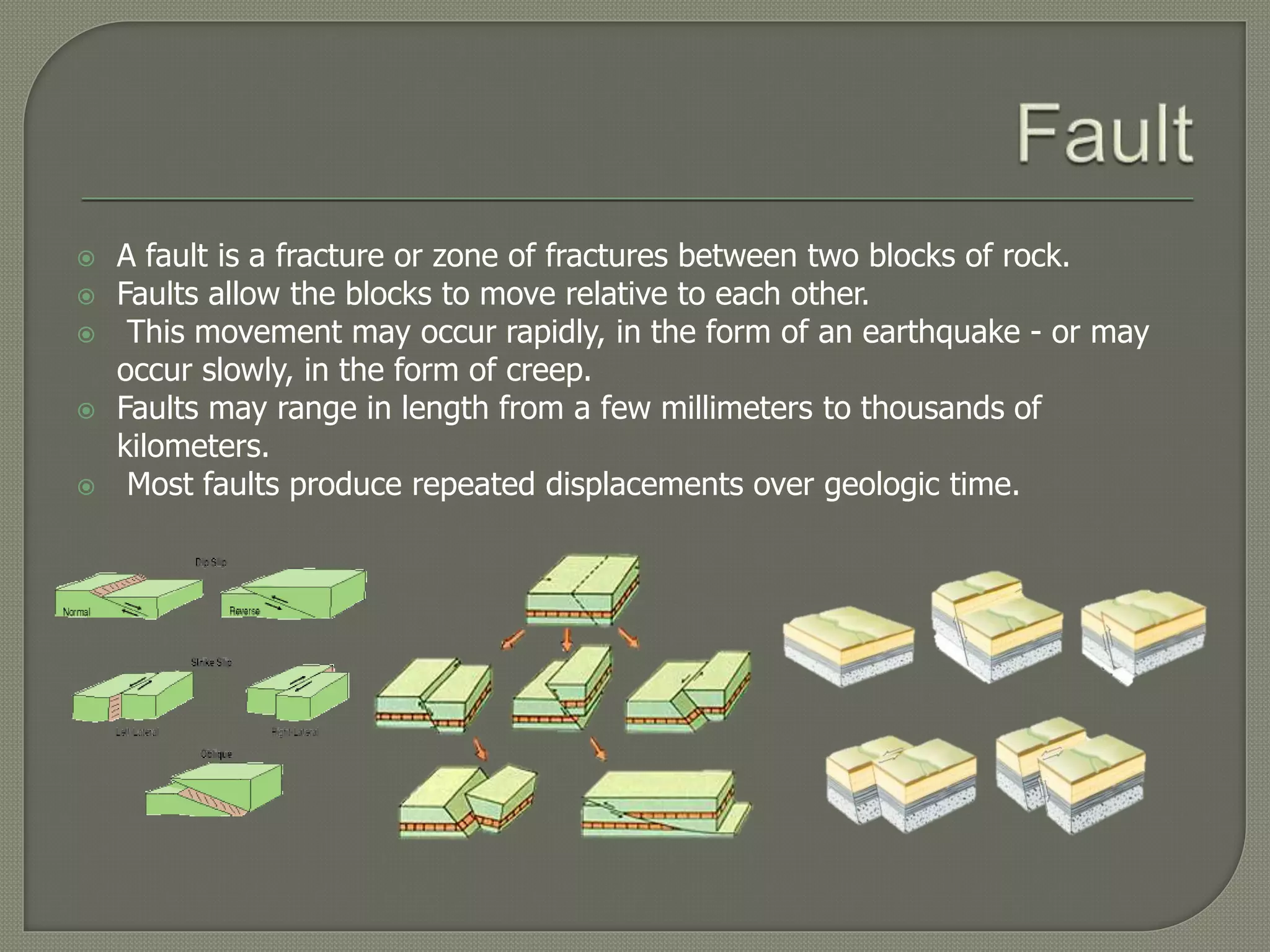
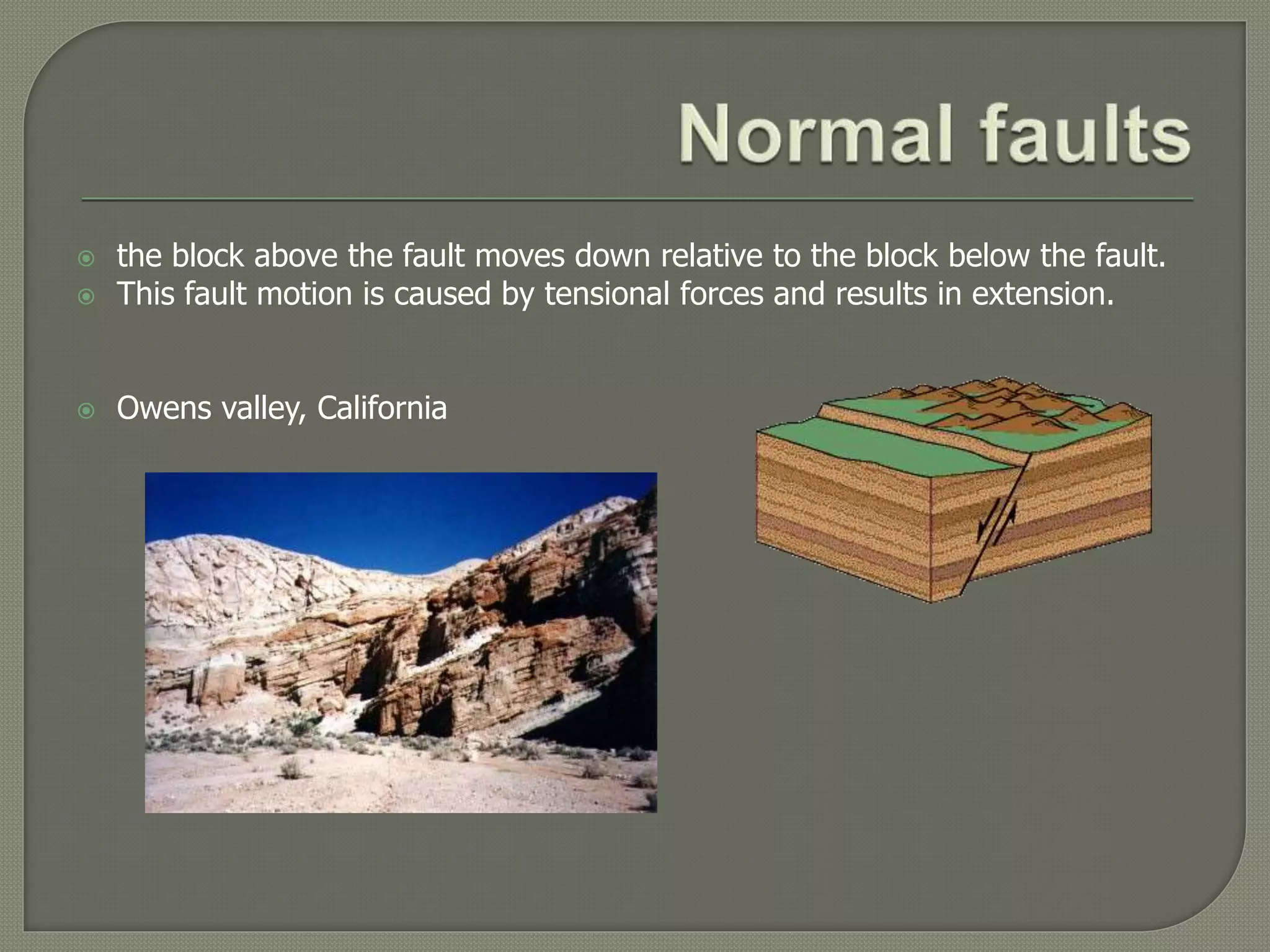
Savaros Phanom-upatham No.5
Monchanok Sankaew No.6
Sasivimon Rujirat No.10
Natatha Pienchobtham No.16
 A fault is a fracture or zone of fractures between two blocks of rock.
 Faults allow the blocks to move relative to each other.
 This movement may occur rapidly, in the form of an earthquake - or may
occur slowly, in the form of creep.
 Faults may range in length from a few millimeters to thousands of
kilometers.
 Most faults produce repeated displacements over geologic time.
 Faults are cracks in rock caused by forces that compress or stretch a section
of Earth’s crust.
 Earth’s crust is divided up into several tectonic plates that essentially float
on a mantle of plastic, partially melted rocks.
 These plates slide under or slide past one another, stressing the rock along
the edges of each plate.
 A new fault forms when the stress on the rock is great enough to cause a
fracture, and one wall in the fracture moves relative to the other.
 Faults can also appear far from the boundaries between tectonic plates
when stress caused by rising magma from the mantle overcomes the
strength of rocks in the overlying crust.
 Many forces change the surface of the Earth over time.
 The largest force that changes our planet’s surface is movement of Earth's
outer layer in a process called plate tectonics.
 The Earth’s outer layer, called the lithosphere, is broken into plates which fit
together like a jigsaw puzzle.
 These plates move very slowly (about 2 inches per year).
 The Earth is constantly moving and plates were formed by the breaking of
the Earth's surface that slide over the mantel.
 The plates that move apart are called Divergent fault boundaries (mid
Atlantic ridge) or seafloor spreading.
 This is mostly caused by convection in the Mantel.
 Plates that slide by each other are called transform fault boundaries or "slip
faulting"
 the block above the fault moves down relative to the block below the fault.
 This fault motion is caused by tensional forces and results in extension.
 Owens valley, California
 Topographic features found in a normal fault zone forming ridges and
valleys.
 A graben represents a block of land that has dropped down relative to
the landscape
• Such as dead valley, Jordan-dead sea , and etc.
 A horst represents a block of land remaining higher than the general
landscape.
• Such as The Vosges Mountains of France, the Palestine Plateau, and etc.
 The block above the fault moves up relative to the block below the fault.
 Caused by compression forces and results in shortening.
 If the dip of the fault plane is small
• called a thrust fault
 Rocky Mountains, Himalayas
 Strike-slip faults involve motion which is parallel to the strike of the faul
 frequently described as a "side-by-side" motion.
 Strike-slip faults are further described as "right-lateral" (dextral) or "left-
lateral" (sinistral) depending if the block opposite the viewer moved to the
right or left respectively.
 Anatolian Fault, Turkey
=right lateral fault
 A transform fault is a type of strike-slip fault where in the relative horizontal
slip is accommodating the movement between two ocean ridges or other
tectonic boundaries.
 Only occur at the boundary between two plates
 San Andreas Fault, California=right lateral fault
 Oblique-slip faulting is a combination of dip-slip fault and strike-slip fault.
 Therefore, there is a space between the faces of the fault.
 One side is higher, vertically, than the other
 Escarpments and mountains hinder transport development.
 Rift valleys are very hot and only suitable for grazing
• they are in the rain shadow unless irrigation is practised as with the case of mubuku.
 There is severe soil erosion and mass wasting on the step slopes which
result in the destruction of soil surface, crops and at times people's property.
• For example Rwenzori mountains.
 It is difficult to settle on the steep areas on the rift valley escarpments.
 High temperatures lead to shortage of water.
 Earthquakes (tremors) which destroy property
 Little rainfall or drought in the Rain shadow areas
 Poor means of transport and communication because of the steep
escarpments
 Salty lakes because of high temperatures and high evaporation rates
 Soil erosion and land slides especially on the steep slopes
 https://answers.yahoo.com/question/index?qid=20100704215718AAq5
mMb
 http://scec.usc.edu/internships/useit/eqbasicinfo
 http://darkwing.uoregon.edu/~millerm/SSfaults.html
 http://www.iris.edu/hq/programs/education_and_outreach/animations/2
 http://eqseis.geosc.psu.edu/~cammon/HTML/Classes/IntroQuakes/Note
s/faults.html
 http://blogs.britannica.com/2011/02/how-fault-lines-form/
 https://answers.yahoo.com/question/index?qid=20080308174950AA
olkZi
 http://www.elateafrica.org/elate/geography/earthmovements/faultiing.
html

Fault

  • 1.
    Savaros Phanom-upatham No.5 MonchanokSankaew No.6 Sasivimon Rujirat No.10 Natatha Pienchobtham No.16
  • 2.
     A faultis a fracture or zone of fractures between two blocks of rock.  Faults allow the blocks to move relative to each other.  This movement may occur rapidly, in the form of an earthquake - or may occur slowly, in the form of creep.  Faults may range in length from a few millimeters to thousands of kilometers.  Most faults produce repeated displacements over geologic time.
  • 3.
     Faults arecracks in rock caused by forces that compress or stretch a section of Earth’s crust.  Earth’s crust is divided up into several tectonic plates that essentially float on a mantle of plastic, partially melted rocks.  These plates slide under or slide past one another, stressing the rock along the edges of each plate.  A new fault forms when the stress on the rock is great enough to cause a fracture, and one wall in the fracture moves relative to the other.  Faults can also appear far from the boundaries between tectonic plates when stress caused by rising magma from the mantle overcomes the strength of rocks in the overlying crust.
  • 4.
     Many forceschange the surface of the Earth over time.  The largest force that changes our planet’s surface is movement of Earth's outer layer in a process called plate tectonics.  The Earth’s outer layer, called the lithosphere, is broken into plates which fit together like a jigsaw puzzle.  These plates move very slowly (about 2 inches per year).  The Earth is constantly moving and plates were formed by the breaking of the Earth's surface that slide over the mantel.  The plates that move apart are called Divergent fault boundaries (mid Atlantic ridge) or seafloor spreading.  This is mostly caused by convection in the Mantel.  Plates that slide by each other are called transform fault boundaries or "slip faulting"
  • 6.
     the blockabove the fault moves down relative to the block below the fault.  This fault motion is caused by tensional forces and results in extension.  Owens valley, California
  • 7.
     Topographic featuresfound in a normal fault zone forming ridges and valleys.  A graben represents a block of land that has dropped down relative to the landscape • Such as dead valley, Jordan-dead sea , and etc.  A horst represents a block of land remaining higher than the general landscape. • Such as The Vosges Mountains of France, the Palestine Plateau, and etc.
  • 8.
     The blockabove the fault moves up relative to the block below the fault.  Caused by compression forces and results in shortening.  If the dip of the fault plane is small • called a thrust fault  Rocky Mountains, Himalayas
  • 9.
     Strike-slip faultsinvolve motion which is parallel to the strike of the faul  frequently described as a "side-by-side" motion.  Strike-slip faults are further described as "right-lateral" (dextral) or "left- lateral" (sinistral) depending if the block opposite the viewer moved to the right or left respectively.  Anatolian Fault, Turkey =right lateral fault
  • 10.
     A transformfault is a type of strike-slip fault where in the relative horizontal slip is accommodating the movement between two ocean ridges or other tectonic boundaries.  Only occur at the boundary between two plates  San Andreas Fault, California=right lateral fault
  • 11.
     Oblique-slip faultingis a combination of dip-slip fault and strike-slip fault.  Therefore, there is a space between the faces of the fault.  One side is higher, vertically, than the other
  • 12.
     Escarpments andmountains hinder transport development.  Rift valleys are very hot and only suitable for grazing • they are in the rain shadow unless irrigation is practised as with the case of mubuku.  There is severe soil erosion and mass wasting on the step slopes which result in the destruction of soil surface, crops and at times people's property. • For example Rwenzori mountains.  It is difficult to settle on the steep areas on the rift valley escarpments.
  • 13.
     High temperatureslead to shortage of water.  Earthquakes (tremors) which destroy property  Little rainfall or drought in the Rain shadow areas  Poor means of transport and communication because of the steep escarpments  Salty lakes because of high temperatures and high evaporation rates  Soil erosion and land slides especially on the steep slopes
  • 14.
     https://answers.yahoo.com/question/index?qid=20100704215718AAq5 mMb  http://scec.usc.edu/internships/useit/eqbasicinfo http://darkwing.uoregon.edu/~millerm/SSfaults.html  http://www.iris.edu/hq/programs/education_and_outreach/animations/2  http://eqseis.geosc.psu.edu/~cammon/HTML/Classes/IntroQuakes/Note s/faults.html  http://blogs.britannica.com/2011/02/how-fault-lines-form/  https://answers.yahoo.com/question/index?qid=20080308174950AA olkZi  http://www.elateafrica.org/elate/geography/earthmovements/faultiing. html