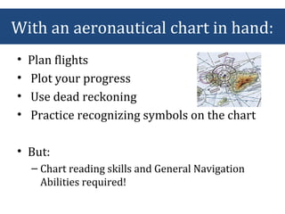
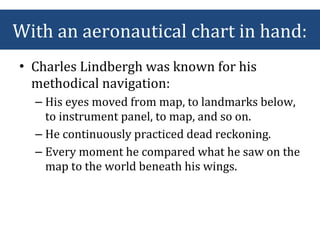
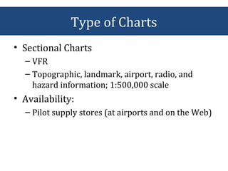
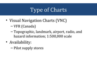
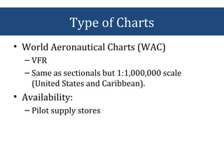
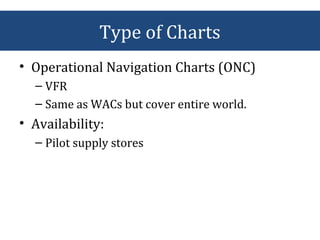
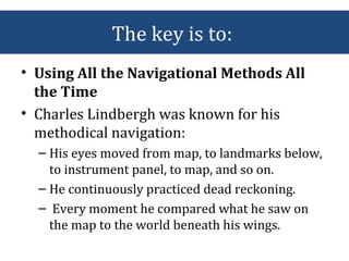
Here you will find everything that you need to know about Aviation Charts right from their history, evolution and the type of charts that we use today.
Airports Authority Of India:The Airports Authority of India (AAI) under the Ministry of Civil Aviation is responsible for creating, upgrading, maintaining and managing civil aviation infrastructure in India. It provides Air Traffic Management (ATM) services over Indian airspace and adjoining oceanic areas.
It manages a total of 125 airports, including 11 International Airports, 8 Custom Airports, 81 Domestic Airports and 25 Civil enclave at Military Airfields.
introduction:The Airports Authority of India provides air traffic services as per AAI Act 1995. These services are - air traffic control service, flight information service, and alerting service. In order to achieve the objectives of air traffic services there is a need to specify procedures necessary for the safety of air navigation for uniform application throughout India.
Distance Measuring Equipment (DME) power point Presentation for aircraftPrabhat K.C.
Distance Measuring Equipment (DME) is a measuring device using ground and air components to determine the slant range of an aircraft from a point.
It is a radio navigation technology that measures the slant range (distance) between an aircraft and a ground station by timing the propagation delay of radio signals in the frequency band between 960 and 1215 megahertz (MHz).
Instrument Landing System is a system installed in the aeroplanes for a safe landing. This slide includes all the necessary details about the system, components, installations, working, upgradations.
In this presentation, there are ten steps which help to plan the flight and a flight plan contain all the information regarding aircraft such as fuel, climate information, and the different route for destination and much more.
Are you flying a drone or thinking of buying one? This webinar covers all things related to drones or unmanned aerial systems (UAS) as well as best practices and legal considerations. Once reserved for use by the military and dedicated hobbyists, drones now extend to a variety of personal applications and recreation as well as commercial use, ranging from surveying and video production to search and rescue and even law enforcement. While the guidance for drone use is evolving, it’s important to understand the current rules and adopt standard operating procedures to ensure your safe missions and that you’re meeting community expectations.
Navigation design alternatives for websitesCarolyn King
Presentation done for Brisbane Web Design Meetup (18 Nov 2010) about what I learned about website navigation design in 2010, including a look back at web designs from the 1990s and a review of current styles of navigation.
Part 1 of 3, most pilots loose the basics when they start flying due to numerous reasons. Whatever your reason, don't let not coming to this seminar be one of them. This three part series will fill in the memory gaps and show you how easy it can be to understand weather systems.
Introduction, hydrologic cycle, climate and water m1Bibhabasu Mohanty
Introduction, Hydrologic cycle, Climate and water availability, Water balances,
Precipitation: Forms, Classification, Variability, Measurement, Data analysis, Evaporation and its measurement, Evapotranspiration and its measurement, Penman Monteith method. Infiltration: Factors affection infiltration, Horton’s equation and Green Ampt method.
This slideshow was made for an invited talk at a local radio club that took place in early 2013. It introduces the methods of navigation and gives overview on the role of aerodrome and airspace traffic control.
This powerpoint has some copyrighted materials which I don't have copyright for. Please msg/comment to let me know so I can amend/delete it.
The slides are designed on the topic of Navigation. How GPS plays a significant role? How many airspace are there in the world? What are the navigational aids that are used in Aviation?
Acetabularia Information For Class 9 .docxvaibhavrinwa19
Acetabularia acetabulum is a single-celled green alga that in its vegetative state is morphologically differentiated into a basal rhizoid and an axially elongated stalk, which bears whorls of branching hairs. The single diploid nucleus resides in the rhizoid.
Operation “Blue Star” is the only event in the history of Independent India where the state went into war with its own people. Even after about 40 years it is not clear if it was culmination of states anger over people of the region, a political game of power or start of dictatorial chapter in the democratic setup.
The people of Punjab felt alienated from main stream due to denial of their just demands during a long democratic struggle since independence. As it happen all over the word, it led to militant struggle with great loss of lives of military, police and civilian personnel. Killing of Indira Gandhi and massacre of innocent Sikhs in Delhi and other India cities was also associated with this movement.
Francesca Gottschalk - How can education support child empowerment.pptxEduSkills OECD
Francesca Gottschalk from the OECD’s Centre for Educational Research and Innovation presents at the Ask an Expert Webinar: How can education support child empowerment?
Macroeconomics- Movie Location
This will be used as part of your Personal Professional Portfolio once graded.
Objective:
Prepare a presentation or a paper using research, basic comparative analysis, data organization and application of economic information. You will make an informed assessment of an economic climate outside of the United States to accomplish an entertainment industry objective.
Palestine last event orientationfvgnh .pptxRaedMohamed3
An EFL lesson about the current events in Palestine. It is intended to be for intermediate students who wish to increase their listening skills through a short lesson in power point.
Instructions for Submissions thorugh G- Classroom.pptxJheel Barad
This presentation provides a briefing on how to upload submissions and documents in Google Classroom. It was prepared as part of an orientation for new Sainik School in-service teacher trainees. As a training officer, my goal is to ensure that you are comfortable and proficient with this essential tool for managing assignments and fostering student engagement.
Embracing GenAI - A Strategic ImperativePeter Windle
Artificial Intelligence (AI) technologies such as Generative AI, Image Generators and Large Language Models have had a dramatic impact on teaching, learning and assessment over the past 18 months. The most immediate threat AI posed was to Academic Integrity with Higher Education Institutes (HEIs) focusing their efforts on combating the use of GenAI in assessment. Guidelines were developed for staff and students, policies put in place too. Innovative educators have forged paths in the use of Generative AI for teaching, learning and assessments leading to pockets of transformation springing up across HEIs, often with little or no top-down guidance, support or direction.
This Gasta posits a strategic approach to integrating AI into HEIs to prepare staff, students and the curriculum for an evolving world and workplace. We will highlight the advantages of working with these technologies beyond the realm of teaching, learning and assessment by considering prompt engineering skills, industry impact, curriculum changes, and the need for staff upskilling. In contrast, not engaging strategically with Generative AI poses risks, including falling behind peers, missed opportunities and failing to ensure our graduates remain employable. The rapid evolution of AI technologies necessitates a proactive and strategic approach if we are to remain relevant.
Model Attribute Check Company Auto PropertyCeline George
In Odoo, the multi-company feature allows you to manage multiple companies within a single Odoo database instance. Each company can have its own configurations while still sharing common resources such as products, customers, and suppliers.
Honest Reviews of Tim Han LMA Course Program.pptxtimhan337
Personal development courses are widely available today, with each one promising life-changing outcomes. Tim Han’s Life Mastery Achievers (LMA) Course has drawn a lot of interest. In addition to offering my frank assessment of Success Insider’s LMA Course, this piece examines the course’s effects via a variety of Tim Han LMA course reviews and Success Insider comments.
How libraries can support authors with open access requirements for UKRI fund...
Everything About Aviation Charts
1. Everything about Aviation Charts
History, Evolution, Early Usage, Current Usage,
Usage Techniques and Tips, Availability and Using
Charts in Flight Planning
(AHSAN_ BS. Aviation Management 11332_3A_FP)
2. With an aeronautical chart in hand:
• Plan flights
• Plot your progress
• Use dead reckoning
• Practice recognizing symbols on the chart
• But:
– Chart reading skills and General Navigation
Abilities required!
3. • Charles Lindbergh was known for his
methodical navigation:
– His eyes moved from map, to landmarks below,
to instrument panel, to map, and so on.
– He continuously practiced dead reckoning.
– Every moment he compared what he saw on the
map to the world beneath his wings.
With an aeronautical chart in hand:
5. • Early flight instructions might have read:
– "From the runway follow the train tracks below,
keeping the river and a large red barn on your
left. Then fly toward a tall evergreen tree and a
small town with a white train depot at the
intersection of two roads..."
Old fashioned Navigation
6. The sky was truly the limit!!!
• Pilots could fly virtually anywhere without
permission from anyone; there were few
flight regulations.
7. Drivers or Pilots?
• During aviation's early years, pilots flew by
simply observing and following visual
elements on the landscape, such as lakes,
rivers, roads, and train tracks—a
navigational technique called pilotage.
8. Reason for Development:
• As aviation evolved, however,
– pilots and navigation got more sophisticated,
– the skies got more crowded,
– airports developed, and
– the need arose for detailed aeronautical charts.
9. Until the 1920s:
• Few official aeronautical maps existed.
• Aeronautical bulletins:
– that included information about airfields,
– flight instructions, which outlined airfield
approaches and air routes between towns and
cities.
– Compiled from pilots' notes
10. Strip Maps
• In 1926, Congress passed the Air Commerce
Act, which produced the first list of aviation
regulations and required pilots to have
licenses.
• Also, in 1926 and 1927, the Department of
Commerce began publishing maps of civil
airways.
• This program created airway charts, or
"strip maps,“
11. Strip Maps
• Covered 330 miles of flight information.
• The strip maps were a scale of 1:500,000—
or about 8 miles per inch—the same scale
aviation sectional charts use today.
12. Who was Jeppesen?
• Elrey Jeppesen’s license was signed by
Orville Wright.
• He spent time barnstorming, became a flight
instructor, and later worked in aerial
surveying.
• During the winter of 1930 and 1931 his
fellow flyers were killed, he felt their loss
was largely due to the lack of published
flight information.
13. • Jeppesen set out to change things.
• In a black notebook, he recorded field lengths
and notes on lights and various obstacles.
• He drew airport layouts and included the
phone numbers of farmers who could report
weather conditions.
• Soon, pilots asked Jeppesen to share his flight
information so often that he began selling
copies of his black notebook for $10.
Who was Jeppesen?
14. • Today, Jeppesen remains the most
respected source for instrument
aeronautical charts, GPS NavData, and flight
planning software.
• The larger a chart's the scale, the more area
it covers. At the same time, larger-scale
charts include less detail.
Who was Jeppesen?
15. 1st
of the Aeronautical Charts
• The first United States government
aeronautical charts were printed in three
colors and included
– airfields,
– occasional navigational aides,
– topographical features, and
– prominent landmarks.
16. Today!
• Today's complex aviation charts contain nearly
– 150 symbols for cultural and topographical
information, as well as
– 100 symbols for aeronautical information.
– They reflect the mosaic of open and restricted
airspaces,
– controlled and uncontrolled airports,
– and myriad features such as VOR beacons, dams,
airways, compass roses, and radio antennae.
17. Reading the Chart
• Pilotage and chart-reading are a natural
pair.
• The general trick:
– is learning the chart symbols and recognizing
their real-world counterparts.
19. Type of Charts
• SIM Charts (Simulator Charts)
– VFR/IFR
– Designed for navigation in Flight Simulator
(entire world)
• Availability:
– Jeppesen Online Stores
20. Type of Charts
• Sectional Charts
– VFR
– Topographic, landmark, airport, radio, and
hazard information; 1:500,000 scale
• Availability:
– Pilot supply stores (at airports and on the Web)
21. • Visual Navigation Charts (VNC)
– VFR (Canada)
– Topographic, landmark, airport, radio, and
hazard information; 1:500,000 scale
• Availability:
– Pilot supply stores
Type of Charts
22. • World Aeronautical Charts (WAC)
– VFR
– Same as sectionals but 1:1,000,000 scale
(United States and Caribbean).
• Availability:
– Pilot supply stores
Type of Charts
23. • Global Navigation Charts (GNC)
– VFR
– Same as WACs but 1:5,000,000 scale (entire
world).
• Availability:
– Pilot supply stores
Type of Charts
24. • Operational Navigation Charts (ONC)
– VFR
– Same as WACs but cover entire world.
• Availability:
– Pilot supply stores
Type of Charts
25. • Jet Navigation Charts (JNC)
– VFR
– Same as WACs but 1:5,000,000 scale (entire
world).
• Availability:
– Pilot supply stores
Type of Charts
26. • Tactical Pilotage Charts (TPC)
– VFR
– Same as WACs but 1:5,000,000 scale (entire
world).
• Availability:
– Pilot supply stores
Type of Charts
27. • Terminal Area Charts (TAC)
– VFR
– Depicts information similar to sectionals but in
1:250,000 scale in United States Class B
airspace.
• Availability:
– Pilot supply stores
Type of Charts
28. • Visual Terminal Charts (VTC)
– VFR (Canada)
– Depicts information similar to sectionals but in
1:250,000 scale in five Canadian terminal
airspaces
• Availability:
– Pilot supply stores
Type of Charts
29. • Airport/Facility Directory
– VFR/IFR
– Specific airport information
• Availability:
– Pilot supply stores
Type of Charts
30. • Low Altitude Enroute
– IFR
– Airways, airspace boundaries, radio
navigational aids, airports with instrument
approaches and more.
– For use below 18,000 feet MSL
• Availability:
– Jeppesen
Type of Charts
31. • High Altitude Enroute (jets)
– IFR
– Airways, airspace boundaries, radio
navigational aids, selected airports and more.
– For use above 18,000 feet MSL
• Availability:
– Jeppesen
Type of Charts
32. • Instrument Approach Procedures
– IFR
– Procedures for specific precision and non-
precision approaches
• Availability:
– Jeppesen
Type of Charts
33. • DP or Departure Procedures or Standard
Instrument Departure (SID)
– IFR
– Procedures for specific routes
– Used when departing selected airports
• Availability:
– Jeppesen
Type of Charts
34. • STARS (Standard Terminal Arrival Routes)
– IFR
– Procedures for specific routes used when
arriving at selected airports
• Availability:
– Jeppesen
Type of Charts
35. • Aeroplanner.com
– IFR
• Facility:
– STARs,
– DPs,
– Approach procedures
• Availability: On the Web
Online Procedures
36. The key is to:
• Using All the Navigational Methods All
the Time
• Charles Lindbergh was known for his
methodical navigation:
– His eyes moved from map, to landmarks below,
to instrument panel, to map, and so on.
– He continuously practiced dead reckoning.
– Every moment he compared what he saw on
the map to the world beneath his wings.
37. • Sources:
– Federal Aviation Administration (US) FAA
– IFR Charts & Regulations
– Air Safety Institute, US
– Aeronautical Information Manual
– AOPA (Aircraft Owners & Pilot Association)
– Ask me more on: axon.kan@gmail.com
Questions?