Downloaded 1,729 times


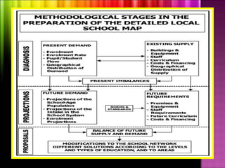


The document outlines several key principles for effective educational facilities and school mapping. It discusses the importance of developing functional facilities based on a comprehensive community plan. The planning process should maximize collaboration, establish a proactive management program, and design schools as neighborhood centers that provide accessible services. School mapping is also described as a dynamic process to optimally plan school distribution, size, and resources based on factors like demographics, environment, and policies. The expected results include prioritizing repair, expansion, and resource allocation needs.


