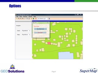
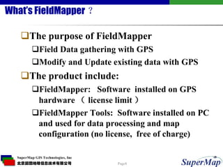
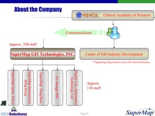
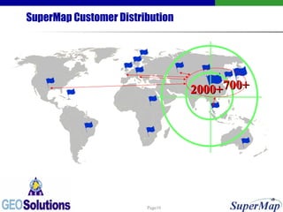
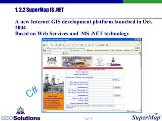
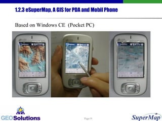
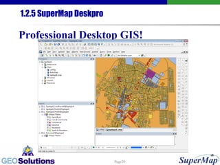
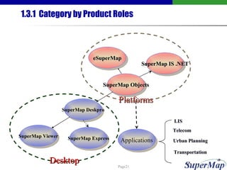
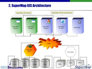
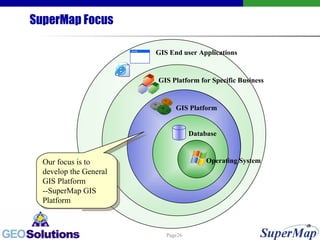
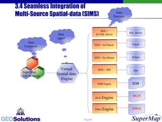
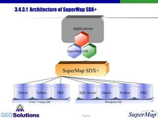
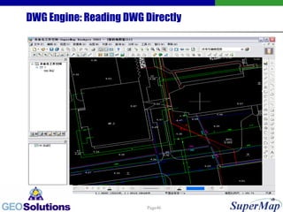
Products of SuperMap GIS
Contents 1. Land Management System 2. Field Mapper
Interface
Options
The Sketch Template
The Lease
2.3 Data Manipulating (3)
What’s FieldMapper ? The purpose of FieldMapper Field Data gathering with GPS Modify and Update existing data with GPS The product include: FieldMapper:  Software  installed on GPS hardware ( license limit )  FieldMapper Tools:  Software installed on PC and used for data processing and map configuration (no license,  free of charge)
2.3 Data Manipulating (3) Project Transforming
2.4 Spatial Analyzing(4) Network Analyzing
2.4 Spatial Analyzing(7) Flood Simulating
SuperMap At a Glance SuperMap GIS Family SuperMap GIS Architecture SuperMap GIS Data Model
About the Company Commercialized SuperMap Japan, Tokyo SuperMap International  Hong Kong Ev-Image INC SuperMap   HangZhou Digital City  Information Technology Ltd Approx.  110 staff Chinese Academy of Sciences SuperMap GIS Technologies, INC. Approx. 350 staff Center of GIS Industry Development * Supporting Organization to the GIS related Industries
1.1 SuperMap GIS Family Catalog SuperMap Objects SuperMap IS .NET eSuperMap SuperMap SDX+ SuperMap Deskpro Others …
Our GIS environment Supporting CAD data structure (object-based structure) and CAD functionality; Not only user-friendly, also developer-friendly and system integrator-friendly; Providing equivalent or better, and more innovative choice in different functional area;  Reducing the entrance barrier of GIS.
SuperMap Customer Distribution 2000+ 700+
With SuperMap Objects , You Can Program with Mainstream Development Environment … ...
1. 2.2 SuperMap IS .NET A new Internet GIS development platform launched in Oct. 2004 Based on Web Services and  MS .NET technology C#
1.2.3 eSuperMap, A GIS for PDA and Mobil Phone Based on Windows CE  (Pocket PC)
1.2.5 SuperMap Deskpro Professional Desktop GIS!
1.3.1  Category by Product Roles SuperMap Viewer SuperMap Deskpro SuperMap Objects SuperMap IS .NET eSuperMap Applications SuperMap Express Desktop Platforms Telecom LIS Urban Planning …… Transportation
1.3.2 Category by View of Data SuperMap Deskpro SuperMap Express SuperMap Editor SuperMap Objects eSuperMap SuperMap IS .NET Data managing Data Processing Data publishing
1.3.3 Category by User’s Role SuperMap Objects  eSuperMap SuperMap IS .NET SuperMap Deskpro SuperMap Express SuperMap Viewer Data Doers Data   Managers Data   Browsers
1.3.4 Category by Run Environment eSuperMap SuperMap IS .NET SuperMap Objects SuperMap Deskpro SuperMap Express SuperMap Editor embeded
2. SuperMap GIS Architecture SuperMap  Express SuperMap  Deskpro SuperMap  Objects SuperMap  IS .NET SIMS SuperMap SDX+ Oracle SQL Server Sybase DB2 File Engine DGN SDB DWG eSuperMap  SuperMap GIS Desktop SuperMap GIS Develop Platform
SuperMap Focus Our focus is to develop the General GIS Platform --SuperMap GIS Platform GIS Platform GIS Platform for Specific Business Database GIS End user Applications Operating System
3. SuperMap GIS Data Model 3.1 Basic Concepts 3.2 Data Model 3.3 Data Storage Schema 3.4 Seamless Integration of  Multi-Source Spatial-data (SIMS) 3.5 Data Exchange
3.1 Basic Concepts 3.1.1 Dataset 3.1.2 Datasource 3.1.3 Layer 3.1.4 Map 3.1.5 Layout 3.1.6 Resource 3.1.7 Workspace
3.1.1 Dataset Dataset is the collection of a set of data that has the same data structure, same projection and same theme. There are two types of dataset in SuperMap, that is Vector Dataset and Raster Dataset. And there are many sub types for both Vector Dataset and Raster Dataset.
3.1.2 Datasource Datasource is the container of a set of datasets that has the same projection.  Datasource is the basic storage unit in SuperMap. One Datasource can contain zero or hundreds of datasets.
3.1.3 Layer After a dataset is viewed in a map window, it becomes a Layer. Layer dose not contain the real data of dataset, but a reference.
3.1.4 Map Map is the container of a set of Layers. One Map can contain zero or multi layers.
3.1.5 Layout Layout is the container of map and it ’ s relevant elements, such as map title, north arrow, scalebar, etc.
3.1.6 Resource Resource is the container of symbol, line and fill styles. It is used to render geometries in order to make different visualization effect.
There are different styles for different types of data when rendering! Symbol Line Style Fill
3.1.7  Workspace Workspace is the container of a set of Datasources, Maps, Layouts and Resources. Workspace is useful in saving the user ’ s working environment.
3.2.2 Data Model GIS Data Model Combined with CAD Data Model Topology-Oriented Data Model Combined with Object-Oriented Data Model Vector Data Model Combined with Raster Data Model
GIS Vs. CAD Advantages Disadvantages GIS Strong attribute managing ability Powerful in spatial analyzing Relatively week in graphic visualizing and editing CAD Powerful in graphic modeling and editing Week attribute managing ability Lack of spatial analyzing ability
Vector Vs. Raster Advantages Disadvantages Vector Perfect in describing discrete spatial entities Accurate in position Easy to measure No mosaic effect Data cost is high Raster Perfect in describing continuous entities Attribute is obvious Large area, large data Mosaic effect
Image Compressing with Wavelet Technology High Compression (30:1-50:1-100:1) Multi-resolution Quick View Support MrSID and ECW 6.34 GB 198 MB
3.4 Seamless Integration of  Multi-Source Spatial-data (SIMS) SQL Server Sybase SDB DGN SDX + for SQL Server SDX + for Oracle SDX + for Sybase SDX+  DM SDB Engine DGN  Engine Virtual  Spatial data  Engine DWG  Engine DWG Data Consumer Data Agent Data Provider Oracle DM SuperMap GIS Software
3.4.1 File  Storage Schema----SDB/SDD Files SDB/SDD is a double-files stroage GIS data format defined by SuperMap.  It adopts the technology of  “ compound document ”  which is a very new technology. In the double-files , SDB file is for the spatial data , and SDD file is Access database for attribute data.
3.4.2 Database Schema --- SuperMap SDX+ SuperMap SDX+ is a powerful Spatial Database Engine. With SuperMap SDX+, we can store and manage our spatial and non-spatial data with RDBMS. SuperMap SDX+ is an important part of SuperMap GIS Data Model
3.4.3.1  Architecture of SuperMap SDX+ Windows OS Unix / Linux OS Oracle Sybase DB2 SuperMap SDX+ Applications DB2 SQL Server Oracle Sybase SuperMap GIS
3.4.3 DGN Engine: Reading DGN Directly
DWG Engine: Reading DWG Directly
The End, Thanks For Your Attention!

Dsm Presentation

  • 1.
  • 2.
    Contents 1. LandManagement System 2. Field Mapper
  • 3.
  • 4.
  • 5.
  • 6.
  • 7.
  • 8.
    What’s FieldMapper ?The purpose of FieldMapper Field Data gathering with GPS Modify and Update existing data with GPS The product include: FieldMapper: Software installed on GPS hardware ( license limit ) FieldMapper Tools: Software installed on PC and used for data processing and map configuration (no license, free of charge)
  • 9.
    2.3 Data Manipulating(3) Project Transforming
  • 10.
    2.4 Spatial Analyzing(4)Network Analyzing
  • 11.
    2.4 Spatial Analyzing(7)Flood Simulating
  • 12.
    SuperMap At aGlance SuperMap GIS Family SuperMap GIS Architecture SuperMap GIS Data Model
  • 13.
    About the CompanyCommercialized SuperMap Japan, Tokyo SuperMap International Hong Kong Ev-Image INC SuperMap HangZhou Digital City Information Technology Ltd Approx. 110 staff Chinese Academy of Sciences SuperMap GIS Technologies, INC. Approx. 350 staff Center of GIS Industry Development * Supporting Organization to the GIS related Industries
  • 14.
    1.1 SuperMap GISFamily Catalog SuperMap Objects SuperMap IS .NET eSuperMap SuperMap SDX+ SuperMap Deskpro Others …
  • 15.
    Our GIS environmentSupporting CAD data structure (object-based structure) and CAD functionality; Not only user-friendly, also developer-friendly and system integrator-friendly; Providing equivalent or better, and more innovative choice in different functional area; Reducing the entrance barrier of GIS.
  • 16.
  • 17.
    With SuperMap Objects, You Can Program with Mainstream Development Environment … ...
  • 18.
    1. 2.2 SuperMapIS .NET A new Internet GIS development platform launched in Oct. 2004 Based on Web Services and MS .NET technology C#
  • 19.
    1.2.3 eSuperMap, AGIS for PDA and Mobil Phone Based on Windows CE (Pocket PC)
  • 20.
    1.2.5 SuperMap DeskproProfessional Desktop GIS!
  • 21.
    1.3.1 Categoryby Product Roles SuperMap Viewer SuperMap Deskpro SuperMap Objects SuperMap IS .NET eSuperMap Applications SuperMap Express Desktop Platforms Telecom LIS Urban Planning …… Transportation
  • 22.
    1.3.2 Category byView of Data SuperMap Deskpro SuperMap Express SuperMap Editor SuperMap Objects eSuperMap SuperMap IS .NET Data managing Data Processing Data publishing
  • 23.
    1.3.3 Category byUser’s Role SuperMap Objects eSuperMap SuperMap IS .NET SuperMap Deskpro SuperMap Express SuperMap Viewer Data Doers Data Managers Data Browsers
  • 24.
    1.3.4 Category byRun Environment eSuperMap SuperMap IS .NET SuperMap Objects SuperMap Deskpro SuperMap Express SuperMap Editor embeded
  • 25.
    2. SuperMap GISArchitecture SuperMap Express SuperMap Deskpro SuperMap Objects SuperMap IS .NET SIMS SuperMap SDX+ Oracle SQL Server Sybase DB2 File Engine DGN SDB DWG eSuperMap SuperMap GIS Desktop SuperMap GIS Develop Platform
  • 26.
    SuperMap Focus Ourfocus is to develop the General GIS Platform --SuperMap GIS Platform GIS Platform GIS Platform for Specific Business Database GIS End user Applications Operating System
  • 27.
    3. SuperMap GISData Model 3.1 Basic Concepts 3.2 Data Model 3.3 Data Storage Schema 3.4 Seamless Integration of Multi-Source Spatial-data (SIMS) 3.5 Data Exchange
  • 28.
    3.1 Basic Concepts3.1.1 Dataset 3.1.2 Datasource 3.1.3 Layer 3.1.4 Map 3.1.5 Layout 3.1.6 Resource 3.1.7 Workspace
  • 29.
    3.1.1 Dataset Datasetis the collection of a set of data that has the same data structure, same projection and same theme. There are two types of dataset in SuperMap, that is Vector Dataset and Raster Dataset. And there are many sub types for both Vector Dataset and Raster Dataset.
  • 30.
    3.1.2 Datasource Datasourceis the container of a set of datasets that has the same projection. Datasource is the basic storage unit in SuperMap. One Datasource can contain zero or hundreds of datasets.
  • 31.
    3.1.3 Layer Aftera dataset is viewed in a map window, it becomes a Layer. Layer dose not contain the real data of dataset, but a reference.
  • 32.
    3.1.4 Map Mapis the container of a set of Layers. One Map can contain zero or multi layers.
  • 33.
    3.1.5 Layout Layoutis the container of map and it ’ s relevant elements, such as map title, north arrow, scalebar, etc.
  • 34.
    3.1.6 Resource Resourceis the container of symbol, line and fill styles. It is used to render geometries in order to make different visualization effect.
  • 35.
    There are differentstyles for different types of data when rendering! Symbol Line Style Fill
  • 36.
    3.1.7 WorkspaceWorkspace is the container of a set of Datasources, Maps, Layouts and Resources. Workspace is useful in saving the user ’ s working environment.
  • 37.
    3.2.2 Data ModelGIS Data Model Combined with CAD Data Model Topology-Oriented Data Model Combined with Object-Oriented Data Model Vector Data Model Combined with Raster Data Model
  • 38.
    GIS Vs. CADAdvantages Disadvantages GIS Strong attribute managing ability Powerful in spatial analyzing Relatively week in graphic visualizing and editing CAD Powerful in graphic modeling and editing Week attribute managing ability Lack of spatial analyzing ability
  • 39.
    Vector Vs. RasterAdvantages Disadvantages Vector Perfect in describing discrete spatial entities Accurate in position Easy to measure No mosaic effect Data cost is high Raster Perfect in describing continuous entities Attribute is obvious Large area, large data Mosaic effect
  • 40.
    Image Compressing withWavelet Technology High Compression (30:1-50:1-100:1) Multi-resolution Quick View Support MrSID and ECW 6.34 GB 198 MB
  • 41.
    3.4 Seamless Integrationof Multi-Source Spatial-data (SIMS) SQL Server Sybase SDB DGN SDX + for SQL Server SDX + for Oracle SDX + for Sybase SDX+ DM SDB Engine DGN Engine Virtual Spatial data Engine DWG Engine DWG Data Consumer Data Agent Data Provider Oracle DM SuperMap GIS Software
  • 42.
    3.4.1 File Storage Schema----SDB/SDD Files SDB/SDD is a double-files stroage GIS data format defined by SuperMap. It adopts the technology of “ compound document ” which is a very new technology. In the double-files , SDB file is for the spatial data , and SDD file is Access database for attribute data.
  • 43.
    3.4.2 Database Schema--- SuperMap SDX+ SuperMap SDX+ is a powerful Spatial Database Engine. With SuperMap SDX+, we can store and manage our spatial and non-spatial data with RDBMS. SuperMap SDX+ is an important part of SuperMap GIS Data Model
  • 44.
    3.4.3.1 Architectureof SuperMap SDX+ Windows OS Unix / Linux OS Oracle Sybase DB2 SuperMap SDX+ Applications DB2 SQL Server Oracle Sybase SuperMap GIS
  • 45.
    3.4.3 DGN Engine:Reading DGN Directly
  • 46.
    DWG Engine: ReadingDWG Directly
  • 47.
    The End, ThanksFor Your Attention!

Editor's Notes

  • #14 Founded in 1997 Founded from a group research professor and students of Chinese Academy of Sciences; Supported by Chinese Academy of Sciences; A leading GIS software provider in China 300+ Employees 275 in Beijing Headquarter; 30+ in Tokyo; 30+ in Hangzhou; Newly developed in Hong Kong