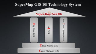
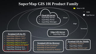
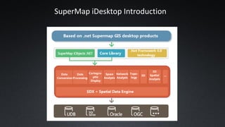
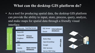
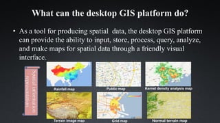
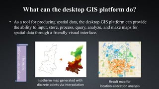
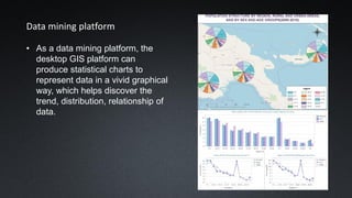
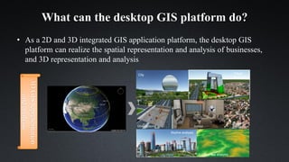
SlideShare a Scribd company logo
SuperMap Software Co., Ltd
V10.0.0
SuperMap Research Institute Product Consulting
SuperMap GIS Platform Products
Main Contents
• SuperMap GIS 10i Technology System
• SuperMap GIS 10i Product Family
• SuperMap iDesktop Introduction
SuperMap GIS 10i Technology System
Cloud Native GIS
Cross Platform GIS
NewThreeDimensionGIS
BigDataGIS
AIGIS
SuperMap GIS 10i Product Family
* SDK
App/Server
Edge GIS Server
• SuperMap iEdge
Cloud GIS Server
• SuperMap iServer
• SuperMap iPortal
• SuperMap iManager
Terminal GIS for Browser
• SuperMap iClient JavaScript *
• SuperMap iClient Python*
• SuperMap iClient3D for WebGL*
Terminal GIS for Mobile
• SuperMap iMobile*
• SuperMap iTablet
• SuperMap iMobile Lite*
Terminal GIS for PC
• SuperMap iObjects Java*
• SuperMap iObjects .NET*
• SuperMap iObjects C++*
• SuperMap iObjects Python *
• SuperMap iObjects for Spark*
• SuperMap iDesktop Java
• SuperMap iDesktop .NET
Cloud
Edge
Terminal
New in 10i
SuperMap iDesktop Introduction
What Can the Desktop GIS Platform Do?
Spatial data production tool
Data mining platform
2D & 3D integrated GIS application platform
Desktop GIS development platform
What can the desktop GIS platform do?
• As a tool for producing spatial data, the desktop GIS platform
can provide the ability to input, store, process, query, analyze,
and make maps for spatial data through a friendly visual
interface.
Spatialdata
acquisitionand
processing
Original data files MapResult data
Point
Lin
e
region
What can the desktop GIS platform do?
• As a tool for producing spatial data, the desktop GIS platform
can provide the ability to input, store, process, query, analyze,
and make maps for spatial data through a friendly visual
interface.
SuperMap formats
Chinese
databases
DB2
MySQL
PostgreSQL
Open source
databases
UDB/UDD
BeyonDB
HighgoDB
KingBase
DM
International
databases
SQL Server
Oracle
WEBmaps
Baidu Map
OpenStreetMap
Google
OGC Services
iServer REST Map
Spatialdata
management
What can the desktop GIS platform do?
• As a tool for producing spatial data, the desktop GIS platform
can provide the ability to input, store, process, query, analyze,
and make maps for spatial data through a friendly visual
interface.
Spatialinformation
representation
Rainfall map
Terrain image map Grid map Normal terrain map
Kernel density analysis mapPublic map
What can the desktop GIS platform do?
• As a tool for producing spatial data, the desktop GIS platform can provide
the ability to input, store, process, query, analyze, and make maps for
spatial data through a friendly visual interface.
Thematic
informationanalysis
Isotherm map generated with
discrete points via interpolation
Result map for
location-allocation analysis
Data mining platform
• As a data mining platform, the
desktop GIS platform can
produce statistical charts to
represent data in a vivid graphical
way, which helps discover the
trend, distribution, relationship of
data.
What can the desktop GIS platform do?
• As a 2D and 3D integrated GIS application platform, the desktop GIS
platform can realize the spatial representation and analysis of businesses,
and 3D representation and analysis
太
空
City Visual
analysis
Contour line analysis
Skyline analysis
IndoorUnderground
Oblique
photograph
3DGISrepresentation
andanalysis
What can the desktop GIS platform do?
• As desktop GIS development platform, it enables you to customize the
interface, develop your own business modules based on the existing
desktop GIS platform to quickly customize your own desktop GIS
application platform Logo Title
Functions
Systemcustomization
anddevelopment
Splash screen
Product Consulting
SuperMap Research Institute Product Consulting
Thank You!

More Related Content

What's hot

Getting to Know ArcGIS Pro
Getting to Know ArcGIS ProGetting to Know ArcGIS Pro
Getting to Know ArcGIS Pro
Esri UK
 
Imagery and beyond - BK 2016
Imagery and beyond - BK 2016Imagery and beyond - BK 2016
Imagery and beyond - BK 2016
Geodata AS
 
Network Mapping - Esri UK Annual Conference 2016
Network Mapping - Esri UK Annual Conference 2016Network Mapping - Esri UK Annual Conference 2016
Network Mapping - Esri UK Annual Conference 2016
Esri UK
 
Designing and Using Cached Map
Designing and Using Cached Map Designing and Using Cached Map
Designing and Using Cached Map M.Muneeb Ashraf
 
Esri in AWS Cloud
Esri in AWS CloudEsri in AWS Cloud
Nebula Graph nMeetup in Shanghai - Meet with Graph Technology Enthusiasts
Nebula Graph nMeetup in Shanghai - Meet with Graph Technology EnthusiastsNebula Graph nMeetup in Shanghai - Meet with Graph Technology Enthusiasts
Nebula Graph nMeetup in Shanghai - Meet with Graph Technology Enthusiasts
Nebula Graph
 
Esri ArcGIS Federal
Esri ArcGIS FederalEsri ArcGIS Federal
Introduction to Nebula Graph, an Open-Source Distributed Graph Database
Introduction to Nebula Graph, an Open-Source Distributed Graph DatabaseIntroduction to Nebula Graph, an Open-Source Distributed Graph Database
Introduction to Nebula Graph, an Open-Source Distributed Graph Database
Nebula Graph
 
BIM - Esri UK Annual Conference 2016
BIM - Esri UK Annual Conference 2016BIM - Esri UK Annual Conference 2016
BIM - Esri UK Annual Conference 2016
Esri UK
 
Esri Scotland Conf 2016 Forestry Commission
Esri Scotland Conf 2016   Forestry CommissionEsri Scotland Conf 2016   Forestry Commission
Esri Scotland Conf 2016 Forestry Commission
Esri UK
 
QlikMaps 3.0: Create Maps Fast
QlikMaps 3.0: Create Maps FastQlikMaps 3.0: Create Maps Fast
QlikMaps 3.0: Create Maps Fast
QlikMaps
 
Esri Scotland Conf 2016 - SEPA
Esri Scotland Conf 2016 - SEPAEsri Scotland Conf 2016 - SEPA
Esri Scotland Conf 2016 - SEPA
Esri UK
 
The Impact of Always-on Connectivity for Geospatial Applications and Analysis
The Impact of Always-on Connectivity for Geospatial Applications and AnalysisThe Impact of Always-on Connectivity for Geospatial Applications and Analysis
The Impact of Always-on Connectivity for Geospatial Applications and Analysis
SingleStore
 
SEPA - Esri UK Annual Conference 2016
SEPA - Esri UK Annual Conference 2016SEPA - Esri UK Annual Conference 2016
SEPA - Esri UK Annual Conference 2016
Esri UK
 
Kafka + Uber- The World’s Realtime Transit Infrastructure, Aaron Schildkrout
Kafka + Uber- The World’s Realtime Transit Infrastructure, Aaron SchildkroutKafka + Uber- The World’s Realtime Transit Infrastructure, Aaron Schildkrout
Kafka + Uber- The World’s Realtime Transit Infrastructure, Aaron Schildkrout
confluent
 
An Overview of Web GIS and Location Based Services
An Overview of Web GIS and Location Based ServicesAn Overview of Web GIS and Location Based Services
An Overview of Web GIS and Location Based Services
webmapsolutions
 
5 Unexpected Ways To Use Location Analytics
5 Unexpected Ways To Use Location Analytics5 Unexpected Ways To Use Location Analytics
5 Unexpected Ways To Use Location Analytics
QlikMaps
 
Automating ProjectWise with FME
Automating ProjectWise with FMEAutomating ProjectWise with FME
Automating ProjectWise with FME
Safe Software
 
Energy Saving Trust - Esri UK Annual Conference 2016
Energy Saving Trust - Esri UK Annual Conference 2016Energy Saving Trust - Esri UK Annual Conference 2016
Energy Saving Trust - Esri UK Annual Conference 2016
Esri UK
 

What's hot (20)

Getting to Know ArcGIS Pro
Getting to Know ArcGIS ProGetting to Know ArcGIS Pro
Getting to Know ArcGIS Pro
 
Imagery and beyond - BK 2016
Imagery and beyond - BK 2016Imagery and beyond - BK 2016
Imagery and beyond - BK 2016
 
Network Mapping - Esri UK Annual Conference 2016
Network Mapping - Esri UK Annual Conference 2016Network Mapping - Esri UK Annual Conference 2016
Network Mapping - Esri UK Annual Conference 2016
 
Designing and Using Cached Map
Designing and Using Cached Map Designing and Using Cached Map
Designing and Using Cached Map
 
Esri in AWS Cloud
Esri in AWS CloudEsri in AWS Cloud
Esri in AWS Cloud
 
Nebula Graph nMeetup in Shanghai - Meet with Graph Technology Enthusiasts
Nebula Graph nMeetup in Shanghai - Meet with Graph Technology EnthusiastsNebula Graph nMeetup in Shanghai - Meet with Graph Technology Enthusiasts
Nebula Graph nMeetup in Shanghai - Meet with Graph Technology Enthusiasts
 
Esri ArcGIS Federal
Esri ArcGIS FederalEsri ArcGIS Federal
Esri ArcGIS Federal
 
Introduction to Nebula Graph, an Open-Source Distributed Graph Database
Introduction to Nebula Graph, an Open-Source Distributed Graph DatabaseIntroduction to Nebula Graph, an Open-Source Distributed Graph Database
Introduction to Nebula Graph, an Open-Source Distributed Graph Database
 
BIM - Esri UK Annual Conference 2016
BIM - Esri UK Annual Conference 2016BIM - Esri UK Annual Conference 2016
BIM - Esri UK Annual Conference 2016
 
Esri Scotland Conf 2016 Forestry Commission
Esri Scotland Conf 2016   Forestry CommissionEsri Scotland Conf 2016   Forestry Commission
Esri Scotland Conf 2016 Forestry Commission
 
QlikMaps 3.0: Create Maps Fast
QlikMaps 3.0: Create Maps FastQlikMaps 3.0: Create Maps Fast
QlikMaps 3.0: Create Maps Fast
 
Web GIS
Web GISWeb GIS
Web GIS
 
Esri Scotland Conf 2016 - SEPA
Esri Scotland Conf 2016 - SEPAEsri Scotland Conf 2016 - SEPA
Esri Scotland Conf 2016 - SEPA
 
The Impact of Always-on Connectivity for Geospatial Applications and Analysis
The Impact of Always-on Connectivity for Geospatial Applications and AnalysisThe Impact of Always-on Connectivity for Geospatial Applications and Analysis
The Impact of Always-on Connectivity for Geospatial Applications and Analysis
 
SEPA - Esri UK Annual Conference 2016
SEPA - Esri UK Annual Conference 2016SEPA - Esri UK Annual Conference 2016
SEPA - Esri UK Annual Conference 2016
 
Kafka + Uber- The World’s Realtime Transit Infrastructure, Aaron Schildkrout
Kafka + Uber- The World’s Realtime Transit Infrastructure, Aaron SchildkroutKafka + Uber- The World’s Realtime Transit Infrastructure, Aaron Schildkrout
Kafka + Uber- The World’s Realtime Transit Infrastructure, Aaron Schildkrout
 
An Overview of Web GIS and Location Based Services
An Overview of Web GIS and Location Based ServicesAn Overview of Web GIS and Location Based Services
An Overview of Web GIS and Location Based Services
 
5 Unexpected Ways To Use Location Analytics
5 Unexpected Ways To Use Location Analytics5 Unexpected Ways To Use Location Analytics
5 Unexpected Ways To Use Location Analytics
 
Automating ProjectWise with FME
Automating ProjectWise with FMEAutomating ProjectWise with FME
Automating ProjectWise with FME
 
Energy Saving Trust - Esri UK Annual Conference 2016
Energy Saving Trust - Esri UK Annual Conference 2016Energy Saving Trust - Esri UK Annual Conference 2016
Energy Saving Trust - Esri UK Annual Conference 2016
 

Similar to 0 supermapproductsintroduction

Super map gis 8c
Super map gis 8cSuper map gis 8c
Super map gis 8c
Daniel PI
 
Introduction of super map gis 10i(2020) (1)
Introduction of super map gis 10i(2020) (1)Introduction of super map gis 10i(2020) (1)
Introduction of super map gis 10i(2020) (1)
GeoMedeelel
 
GIS as a Platform by Sam Viana (Esri Inc)
GIS as a Platform by Sam Viana (Esri Inc)GIS as a Platform by Sam Viana (Esri Inc)
GIS as a Platform by Sam Viana (Esri Inc)
Esri South Africa
 
Esri South Africa ArcGIS 10.2 Rollout
Esri South Africa ArcGIS 10.2 Rollout Esri South Africa ArcGIS 10.2 Rollout
Esri South Africa ArcGIS 10.2 Rollout
Esri South Africa
 
Be Location Intelligent with MapInfo Pro v2019
Be Location Intelligent with MapInfo Pro v2019Be Location Intelligent with MapInfo Pro v2019
Be Location Intelligent with MapInfo Pro v2019
Peter Horsbøll Møller
 
Dsm Presentation
Dsm PresentationDsm Presentation
Dsm Presentationrichoe
 
Building Mobile Cross-Platform Geospatial Apps, Nick Landry
Building Mobile Cross-Platform Geospatial Apps, Nick LandryBuilding Mobile Cross-Platform Geospatial Apps, Nick Landry
Building Mobile Cross-Platform Geospatial Apps, Nick LandryXamarin
 
ArcGIS - A Platform for Developers & Startups
ArcGIS - A Platform for Developers & StartupsArcGIS - A Platform for Developers & Startups
ArcGIS - A Platform for Developers & Startups
Esri Ireland
 
NDGeospatialSummit2019 - ArcGIS Enterprise – Power Your Location Intelligence
NDGeospatialSummit2019 - ArcGIS Enterprise – Power Your Location IntelligenceNDGeospatialSummit2019 - ArcGIS Enterprise – Power Your Location Intelligence
NDGeospatialSummit2019 - ArcGIS Enterprise – Power Your Location Intelligence
North Dakota GIS Hub
 
AvisMap GIS Products Overview
AvisMap GIS Products OverviewAvisMap GIS Products Overview
AvisMap GIS Products Overviewavismapsoftware
 
webgis architecture and practices patterns
webgis architecture and practices patternswebgis architecture and practices patterns
webgis architecture and practices patterns
NguyenVanTuan33
 
SSSI Local Government Seminar June 2012 - Mobile
SSSI Local Government Seminar June 2012 -  MobileSSSI Local Government Seminar June 2012 -  Mobile
SSSI Local Government Seminar June 2012 - Mobile
David Trengove
 
Jefferson Andrade - Esri Dev Summit 2016 #02 - Dev Tools
Jefferson Andrade - Esri Dev Summit 2016 #02 - Dev ToolsJefferson Andrade - Esri Dev Summit 2016 #02 - Dev Tools
Jefferson Andrade - Esri Dev Summit 2016 #02 - Dev Tools
Jefferson Andrade
 
What is GIS?
What is GIS?What is GIS?
What is GIS?deirdre
 
Build with live location data
Build with live location dataBuild with live location data
Build with live location data
Zahra Sdg
 
Architecting the ArcGIS Platform
Architecting the ArcGIS PlatformArchitecting the ArcGIS Platform
Architecting the ArcGIS Platform
Esri UK
 
Esri Mobility Basics 2013
Esri Mobility Basics 2013Esri Mobility Basics 2013
Esri Mobility Basics 2013
Esri South Africa
 
Apps & web solutions with OpenSource - Mani Singh - IMIA Asia Pacific Conference
Apps & web solutions with OpenSource - Mani Singh - IMIA Asia Pacific ConferenceApps & web solutions with OpenSource - Mani Singh - IMIA Asia Pacific Conference
Apps & web solutions with OpenSource - Mani Singh - IMIA Asia Pacific Conference
International Map Industry Association
 

Similar to 0 supermapproductsintroduction (20)

Super map gis 8c
Super map gis 8cSuper map gis 8c
Super map gis 8c
 
Introduction of super map gis 10i(2020) (1)
Introduction of super map gis 10i(2020) (1)Introduction of super map gis 10i(2020) (1)
Introduction of super map gis 10i(2020) (1)
 
GIS as a Platform by Sam Viana (Esri Inc)
GIS as a Platform by Sam Viana (Esri Inc)GIS as a Platform by Sam Viana (Esri Inc)
GIS as a Platform by Sam Viana (Esri Inc)
 
Esri South Africa ArcGIS 10.2 Rollout
Esri South Africa ArcGIS 10.2 Rollout Esri South Africa ArcGIS 10.2 Rollout
Esri South Africa ArcGIS 10.2 Rollout
 
Be Location Intelligent with MapInfo Pro v2019
Be Location Intelligent with MapInfo Pro v2019Be Location Intelligent with MapInfo Pro v2019
Be Location Intelligent with MapInfo Pro v2019
 
Dsm Presentation
Dsm PresentationDsm Presentation
Dsm Presentation
 
Building Mobile Cross-Platform Geospatial Apps, Nick Landry
Building Mobile Cross-Platform Geospatial Apps, Nick LandryBuilding Mobile Cross-Platform Geospatial Apps, Nick Landry
Building Mobile Cross-Platform Geospatial Apps, Nick Landry
 
ArcGIS - A Platform for Developers & Startups
ArcGIS - A Platform for Developers & StartupsArcGIS - A Platform for Developers & Startups
ArcGIS - A Platform for Developers & Startups
 
NDGeospatialSummit2019 - ArcGIS Enterprise – Power Your Location Intelligence
NDGeospatialSummit2019 - ArcGIS Enterprise – Power Your Location IntelligenceNDGeospatialSummit2019 - ArcGIS Enterprise – Power Your Location Intelligence
NDGeospatialSummit2019 - ArcGIS Enterprise – Power Your Location Intelligence
 
AvisMap GIS Products Overview
AvisMap GIS Products OverviewAvisMap GIS Products Overview
AvisMap GIS Products Overview
 
Web Based GIS
Web Based GISWeb Based GIS
Web Based GIS
 
webgis architecture and practices patterns
webgis architecture and practices patternswebgis architecture and practices patterns
webgis architecture and practices patterns
 
SSSI Local Government Seminar June 2012 - Mobile
SSSI Local Government Seminar June 2012 -  MobileSSSI Local Government Seminar June 2012 -  Mobile
SSSI Local Government Seminar June 2012 - Mobile
 
Jefferson Andrade - Esri Dev Summit 2016 #02 - Dev Tools
Jefferson Andrade - Esri Dev Summit 2016 #02 - Dev ToolsJefferson Andrade - Esri Dev Summit 2016 #02 - Dev Tools
Jefferson Andrade - Esri Dev Summit 2016 #02 - Dev Tools
 
What is GIS?
What is GIS?What is GIS?
What is GIS?
 
Build with live location data
Build with live location dataBuild with live location data
Build with live location data
 
Architecting the ArcGIS Platform
Architecting the ArcGIS PlatformArchitecting the ArcGIS Platform
Architecting the ArcGIS Platform
 
Day4_WebGIS
Day4_WebGISDay4_WebGIS
Day4_WebGIS
 
Esri Mobility Basics 2013
Esri Mobility Basics 2013Esri Mobility Basics 2013
Esri Mobility Basics 2013
 
Apps & web solutions with OpenSource - Mani Singh - IMIA Asia Pacific Conference
Apps & web solutions with OpenSource - Mani Singh - IMIA Asia Pacific ConferenceApps & web solutions with OpenSource - Mani Singh - IMIA Asia Pacific Conference
Apps & web solutions with OpenSource - Mani Singh - IMIA Asia Pacific Conference
 

More from GeoMedeelel

Intro mga mon_15mar22
Intro mga mon_15mar22Intro mga mon_15mar22
Intro mga mon_15mar22
GeoMedeelel
 
Presentation 20220316 nandia
Presentation 20220316 nandiaPresentation 20220316 nandia
Presentation 20220316 nandia
GeoMedeelel
 
Developer community -remote-sensing.pptx
Developer community -remote-sensing.pptxDeveloper community -remote-sensing.pptx
Developer community -remote-sensing.pptx
GeoMedeelel
 
Intro mga mon_18feb22
Intro mga mon_18feb22Intro mga mon_18feb22
Intro mga mon_18feb22
GeoMedeelel
 
Agriculture drone intro
Agriculture drone introAgriculture drone intro
Agriculture drone intro
GeoMedeelel
 
Drone 20201216
Drone 20201216Drone 20201216
Drone 20201216
GeoMedeelel
 
Intro mga 15dec2021 (1)
Intro mga 15dec2021 (1)Intro mga 15dec2021 (1)
Intro mga 15dec2021 (1)
GeoMedeelel
 
Unisec global mongolia
Unisec global mongoliaUnisec global mongolia
Unisec global mongolia
GeoMedeelel
 
Bayanmunkh geomeeting
Bayanmunkh geomeetingBayanmunkh geomeeting
Bayanmunkh geomeeting
GeoMedeelel
 
Intro mga mon_19jan2021
Intro mga mon_19jan2021Intro mga mon_19jan2021
Intro mga mon_19jan2021
GeoMedeelel
 
хиймэл дагуулын мэдээ ашиглан ойн биомассийг тооцох 12 25
хиймэл дагуулын мэдээ ашиглан ойн биомассийг тооцох 12 25хиймэл дагуулын мэдээ ашиглан ойн биомассийг тооцох 12 25
хиймэл дагуулын мэдээ ашиглан ойн биомассийг тооцох 12 25
GeoMedeelel
 
Bayanmunkh geomeeting (1)
Bayanmunkh geomeeting (1)Bayanmunkh geomeeting (1)
Bayanmunkh geomeeting (1)
GeoMedeelel
 
хиймэл дагуулын мэдээ ашиглан ойн биомассийг тооцох 12 25
хиймэл дагуулын мэдээ ашиглан ойн биомассийг тооцох 12 25хиймэл дагуулын мэдээ ашиглан ойн биомассийг тооцох 12 25
хиймэл дагуулын мэдээ ашиглан ойн биомассийг тооцох 12 25
GeoMedeelel
 
Intro mga mon_19jan2021
Intro mga mon_19jan2021Intro mga mon_19jan2021
Intro mga mon_19jan2021
GeoMedeelel
 
Chcnav moblie mapping solution2
Chcnav moblie mapping solution2Chcnav moblie mapping solution2
Chcnav moblie mapping solution2
GeoMedeelel
 
5 d world_v5-19
5 d world_v5-19 5 d world_v5-19
5 d world_v5-19
GeoMedeelel
 
Intro mga 18may2021
Intro mga 18may2021Intro mga 18may2021
Intro mga 18may2021
GeoMedeelel
 
Intro mga 14apr2021
Intro mga 14apr2021Intro mga 14apr2021
Intro mga 14apr2021
GeoMedeelel
 
Demonstration of super map ai gis technology
Demonstration of super map ai gis technology  Demonstration of super map ai gis technology
Demonstration of super map ai gis technology
GeoMedeelel
 
Supermap gis 10i(2020) ai gis technology v1.0
Supermap gis 10i(2020) ai gis technology v1.0Supermap gis 10i(2020) ai gis technology v1.0
Supermap gis 10i(2020) ai gis technology v1.0
GeoMedeelel
 

More from GeoMedeelel (20)

Intro mga mon_15mar22
Intro mga mon_15mar22Intro mga mon_15mar22
Intro mga mon_15mar22
 
Presentation 20220316 nandia
Presentation 20220316 nandiaPresentation 20220316 nandia
Presentation 20220316 nandia
 
Developer community -remote-sensing.pptx
Developer community -remote-sensing.pptxDeveloper community -remote-sensing.pptx
Developer community -remote-sensing.pptx
 
Intro mga mon_18feb22
Intro mga mon_18feb22Intro mga mon_18feb22
Intro mga mon_18feb22
 
Agriculture drone intro
Agriculture drone introAgriculture drone intro
Agriculture drone intro
 
Drone 20201216
Drone 20201216Drone 20201216
Drone 20201216
 
Intro mga 15dec2021 (1)
Intro mga 15dec2021 (1)Intro mga 15dec2021 (1)
Intro mga 15dec2021 (1)
 
Unisec global mongolia
Unisec global mongoliaUnisec global mongolia
Unisec global mongolia
 
Bayanmunkh geomeeting
Bayanmunkh geomeetingBayanmunkh geomeeting
Bayanmunkh geomeeting
 
Intro mga mon_19jan2021
Intro mga mon_19jan2021Intro mga mon_19jan2021
Intro mga mon_19jan2021
 
хиймэл дагуулын мэдээ ашиглан ойн биомассийг тооцох 12 25
хиймэл дагуулын мэдээ ашиглан ойн биомассийг тооцох 12 25хиймэл дагуулын мэдээ ашиглан ойн биомассийг тооцох 12 25
хиймэл дагуулын мэдээ ашиглан ойн биомассийг тооцох 12 25
 
Bayanmunkh geomeeting (1)
Bayanmunkh geomeeting (1)Bayanmunkh geomeeting (1)
Bayanmunkh geomeeting (1)
 
хиймэл дагуулын мэдээ ашиглан ойн биомассийг тооцох 12 25
хиймэл дагуулын мэдээ ашиглан ойн биомассийг тооцох 12 25хиймэл дагуулын мэдээ ашиглан ойн биомассийг тооцох 12 25
хиймэл дагуулын мэдээ ашиглан ойн биомассийг тооцох 12 25
 
Intro mga mon_19jan2021
Intro mga mon_19jan2021Intro mga mon_19jan2021
Intro mga mon_19jan2021
 
Chcnav moblie mapping solution2
Chcnav moblie mapping solution2Chcnav moblie mapping solution2
Chcnav moblie mapping solution2
 
5 d world_v5-19
5 d world_v5-19 5 d world_v5-19
5 d world_v5-19
 
Intro mga 18may2021
Intro mga 18may2021Intro mga 18may2021
Intro mga 18may2021
 
Intro mga 14apr2021
Intro mga 14apr2021Intro mga 14apr2021
Intro mga 14apr2021
 
Demonstration of super map ai gis technology
Demonstration of super map ai gis technology  Demonstration of super map ai gis technology
Demonstration of super map ai gis technology
 
Supermap gis 10i(2020) ai gis technology v1.0
Supermap gis 10i(2020) ai gis technology v1.0Supermap gis 10i(2020) ai gis technology v1.0
Supermap gis 10i(2020) ai gis technology v1.0
 

Recently uploaded

Lecture 1 Introduction to games development
Lecture 1 Introduction to games developmentLecture 1 Introduction to games development
Lecture 1 Introduction to games development
abdulrafaychaudhry
 
Custom Healthcare Software for Managing Chronic Conditions and Remote Patient...
Custom Healthcare Software for Managing Chronic Conditions and Remote Patient...Custom Healthcare Software for Managing Chronic Conditions and Remote Patient...
Custom Healthcare Software for Managing Chronic Conditions and Remote Patient...
Mind IT Systems
 
GlobusWorld 2024 Opening Keynote session
GlobusWorld 2024 Opening Keynote sessionGlobusWorld 2024 Opening Keynote session
GlobusWorld 2024 Opening Keynote session
Globus
 
A Comprehensive Look at Generative AI in Retail App Testing.pdf
A Comprehensive Look at Generative AI in Retail App Testing.pdfA Comprehensive Look at Generative AI in Retail App Testing.pdf
A Comprehensive Look at Generative AI in Retail App Testing.pdf
kalichargn70th171
 
Globus Compute wth IRI Workflows - GlobusWorld 2024
Globus Compute wth IRI Workflows - GlobusWorld 2024Globus Compute wth IRI Workflows - GlobusWorld 2024
Globus Compute wth IRI Workflows - GlobusWorld 2024
Globus
 
OpenFOAM solver for Helmholtz equation, helmholtzFoam / helmholtzBubbleFoam
OpenFOAM solver for Helmholtz equation, helmholtzFoam / helmholtzBubbleFoamOpenFOAM solver for Helmholtz equation, helmholtzFoam / helmholtzBubbleFoam
OpenFOAM solver for Helmholtz equation, helmholtzFoam / helmholtzBubbleFoam
takuyayamamoto1800
 
Climate Science Flows: Enabling Petabyte-Scale Climate Analysis with the Eart...
Climate Science Flows: Enabling Petabyte-Scale Climate Analysis with the Eart...Climate Science Flows: Enabling Petabyte-Scale Climate Analysis with the Eart...
Climate Science Flows: Enabling Petabyte-Scale Climate Analysis with the Eart...
Globus
 
AI Pilot Review: The World’s First Virtual Assistant Marketing Suite
AI Pilot Review: The World’s First Virtual Assistant Marketing SuiteAI Pilot Review: The World’s First Virtual Assistant Marketing Suite
AI Pilot Review: The World’s First Virtual Assistant Marketing Suite
Google
 
First Steps with Globus Compute Multi-User Endpoints
First Steps with Globus Compute Multi-User EndpointsFirst Steps with Globus Compute Multi-User Endpoints
First Steps with Globus Compute Multi-User Endpoints
Globus
 
Developing Distributed High-performance Computing Capabilities of an Open Sci...
Developing Distributed High-performance Computing Capabilities of an Open Sci...Developing Distributed High-performance Computing Capabilities of an Open Sci...
Developing Distributed High-performance Computing Capabilities of an Open Sci...
Globus
 
Understanding Globus Data Transfers with NetSage
Understanding Globus Data Transfers with NetSageUnderstanding Globus Data Transfers with NetSage
Understanding Globus Data Transfers with NetSage
Globus
 
top nidhi software solution freedownload
top nidhi software solution freedownloadtop nidhi software solution freedownload
top nidhi software solution freedownload
vrstrong314
 
Enterprise Resource Planning System in Telangana
Enterprise Resource Planning System in TelanganaEnterprise Resource Planning System in Telangana
Enterprise Resource Planning System in Telangana
NYGGS Automation Suite
 
TROUBLESHOOTING 9 TYPES OF OUTOFMEMORYERROR
TROUBLESHOOTING 9 TYPES OF OUTOFMEMORYERRORTROUBLESHOOTING 9 TYPES OF OUTOFMEMORYERROR
TROUBLESHOOTING 9 TYPES OF OUTOFMEMORYERROR
Tier1 app
 
Vitthal Shirke Microservices Resume Montevideo
Vitthal Shirke Microservices Resume MontevideoVitthal Shirke Microservices Resume Montevideo
Vitthal Shirke Microservices Resume Montevideo
Vitthal Shirke
 
How Recreation Management Software Can Streamline Your Operations.pptx
How Recreation Management Software Can Streamline Your Operations.pptxHow Recreation Management Software Can Streamline Your Operations.pptx
How Recreation Management Software Can Streamline Your Operations.pptx
wottaspaceseo
 
Into the Box 2024 - Keynote Day 2 Slides.pdf
Into the Box 2024 - Keynote Day 2 Slides.pdfInto the Box 2024 - Keynote Day 2 Slides.pdf
Into the Box 2024 - Keynote Day 2 Slides.pdf
Ortus Solutions, Corp
 
Enhancing Project Management Efficiency_ Leveraging AI Tools like ChatGPT.pdf
Enhancing Project Management Efficiency_ Leveraging AI Tools like ChatGPT.pdfEnhancing Project Management Efficiency_ Leveraging AI Tools like ChatGPT.pdf
Enhancing Project Management Efficiency_ Leveraging AI Tools like ChatGPT.pdf
Jay Das
 
Using IESVE for Room Loads Analysis - Australia & New Zealand
Using IESVE for Room Loads Analysis - Australia & New ZealandUsing IESVE for Room Loads Analysis - Australia & New Zealand
Using IESVE for Room Loads Analysis - Australia & New Zealand
IES VE
 
A Sighting of filterA in Typelevel Rite of Passage
A Sighting of filterA in Typelevel Rite of PassageA Sighting of filterA in Typelevel Rite of Passage
A Sighting of filterA in Typelevel Rite of Passage
Philip Schwarz
 

Recently uploaded (20)

Lecture 1 Introduction to games development
Lecture 1 Introduction to games developmentLecture 1 Introduction to games development
Lecture 1 Introduction to games development
 
Custom Healthcare Software for Managing Chronic Conditions and Remote Patient...
Custom Healthcare Software for Managing Chronic Conditions and Remote Patient...Custom Healthcare Software for Managing Chronic Conditions and Remote Patient...
Custom Healthcare Software for Managing Chronic Conditions and Remote Patient...
 
GlobusWorld 2024 Opening Keynote session
GlobusWorld 2024 Opening Keynote sessionGlobusWorld 2024 Opening Keynote session
GlobusWorld 2024 Opening Keynote session
 
A Comprehensive Look at Generative AI in Retail App Testing.pdf
A Comprehensive Look at Generative AI in Retail App Testing.pdfA Comprehensive Look at Generative AI in Retail App Testing.pdf
A Comprehensive Look at Generative AI in Retail App Testing.pdf
 
Globus Compute wth IRI Workflows - GlobusWorld 2024
Globus Compute wth IRI Workflows - GlobusWorld 2024Globus Compute wth IRI Workflows - GlobusWorld 2024
Globus Compute wth IRI Workflows - GlobusWorld 2024
 
OpenFOAM solver for Helmholtz equation, helmholtzFoam / helmholtzBubbleFoam
OpenFOAM solver for Helmholtz equation, helmholtzFoam / helmholtzBubbleFoamOpenFOAM solver for Helmholtz equation, helmholtzFoam / helmholtzBubbleFoam
OpenFOAM solver for Helmholtz equation, helmholtzFoam / helmholtzBubbleFoam
 
Climate Science Flows: Enabling Petabyte-Scale Climate Analysis with the Eart...
Climate Science Flows: Enabling Petabyte-Scale Climate Analysis with the Eart...Climate Science Flows: Enabling Petabyte-Scale Climate Analysis with the Eart...
Climate Science Flows: Enabling Petabyte-Scale Climate Analysis with the Eart...
 
AI Pilot Review: The World’s First Virtual Assistant Marketing Suite
AI Pilot Review: The World’s First Virtual Assistant Marketing SuiteAI Pilot Review: The World’s First Virtual Assistant Marketing Suite
AI Pilot Review: The World’s First Virtual Assistant Marketing Suite
 
First Steps with Globus Compute Multi-User Endpoints
First Steps with Globus Compute Multi-User EndpointsFirst Steps with Globus Compute Multi-User Endpoints
First Steps with Globus Compute Multi-User Endpoints
 
Developing Distributed High-performance Computing Capabilities of an Open Sci...
Developing Distributed High-performance Computing Capabilities of an Open Sci...Developing Distributed High-performance Computing Capabilities of an Open Sci...
Developing Distributed High-performance Computing Capabilities of an Open Sci...
 
Understanding Globus Data Transfers with NetSage
Understanding Globus Data Transfers with NetSageUnderstanding Globus Data Transfers with NetSage
Understanding Globus Data Transfers with NetSage
 
top nidhi software solution freedownload
top nidhi software solution freedownloadtop nidhi software solution freedownload
top nidhi software solution freedownload
 
Enterprise Resource Planning System in Telangana
Enterprise Resource Planning System in TelanganaEnterprise Resource Planning System in Telangana
Enterprise Resource Planning System in Telangana
 
TROUBLESHOOTING 9 TYPES OF OUTOFMEMORYERROR
TROUBLESHOOTING 9 TYPES OF OUTOFMEMORYERRORTROUBLESHOOTING 9 TYPES OF OUTOFMEMORYERROR
TROUBLESHOOTING 9 TYPES OF OUTOFMEMORYERROR
 
Vitthal Shirke Microservices Resume Montevideo
Vitthal Shirke Microservices Resume MontevideoVitthal Shirke Microservices Resume Montevideo
Vitthal Shirke Microservices Resume Montevideo
 
How Recreation Management Software Can Streamline Your Operations.pptx
How Recreation Management Software Can Streamline Your Operations.pptxHow Recreation Management Software Can Streamline Your Operations.pptx
How Recreation Management Software Can Streamline Your Operations.pptx
 
Into the Box 2024 - Keynote Day 2 Slides.pdf
Into the Box 2024 - Keynote Day 2 Slides.pdfInto the Box 2024 - Keynote Day 2 Slides.pdf
Into the Box 2024 - Keynote Day 2 Slides.pdf
 
Enhancing Project Management Efficiency_ Leveraging AI Tools like ChatGPT.pdf
Enhancing Project Management Efficiency_ Leveraging AI Tools like ChatGPT.pdfEnhancing Project Management Efficiency_ Leveraging AI Tools like ChatGPT.pdf
Enhancing Project Management Efficiency_ Leveraging AI Tools like ChatGPT.pdf
 
Using IESVE for Room Loads Analysis - Australia & New Zealand
Using IESVE for Room Loads Analysis - Australia & New ZealandUsing IESVE for Room Loads Analysis - Australia & New Zealand
Using IESVE for Room Loads Analysis - Australia & New Zealand
 
A Sighting of filterA in Typelevel Rite of Passage
A Sighting of filterA in Typelevel Rite of PassageA Sighting of filterA in Typelevel Rite of Passage
A Sighting of filterA in Typelevel Rite of Passage
 

0 supermapproductsintroduction

  • 1. SuperMap Software Co., Ltd V10.0.0 SuperMap Research Institute Product Consulting SuperMap GIS Platform Products
  • 2. Main Contents • SuperMap GIS 10i Technology System • SuperMap GIS 10i Product Family • SuperMap iDesktop Introduction
  • 3. SuperMap GIS 10i Technology System Cloud Native GIS Cross Platform GIS NewThreeDimensionGIS BigDataGIS AIGIS
  • 4. SuperMap GIS 10i Product Family * SDK App/Server Edge GIS Server • SuperMap iEdge Cloud GIS Server • SuperMap iServer • SuperMap iPortal • SuperMap iManager Terminal GIS for Browser • SuperMap iClient JavaScript * • SuperMap iClient Python* • SuperMap iClient3D for WebGL* Terminal GIS for Mobile • SuperMap iMobile* • SuperMap iTablet • SuperMap iMobile Lite* Terminal GIS for PC • SuperMap iObjects Java* • SuperMap iObjects .NET* • SuperMap iObjects C++* • SuperMap iObjects Python * • SuperMap iObjects for Spark* • SuperMap iDesktop Java • SuperMap iDesktop .NET Cloud Edge Terminal New in 10i
  • 6. What Can the Desktop GIS Platform Do? Spatial data production tool Data mining platform 2D & 3D integrated GIS application platform Desktop GIS development platform
  • 7. What can the desktop GIS platform do? • As a tool for producing spatial data, the desktop GIS platform can provide the ability to input, store, process, query, analyze, and make maps for spatial data through a friendly visual interface. Spatialdata acquisitionand processing Original data files MapResult data Point Lin e region
  • 8. What can the desktop GIS platform do? • As a tool for producing spatial data, the desktop GIS platform can provide the ability to input, store, process, query, analyze, and make maps for spatial data through a friendly visual interface. SuperMap formats Chinese databases DB2 MySQL PostgreSQL Open source databases UDB/UDD BeyonDB HighgoDB KingBase DM International databases SQL Server Oracle WEBmaps Baidu Map OpenStreetMap Google OGC Services iServer REST Map Spatialdata management
  • 9. What can the desktop GIS platform do? • As a tool for producing spatial data, the desktop GIS platform can provide the ability to input, store, process, query, analyze, and make maps for spatial data through a friendly visual interface. Spatialinformation representation Rainfall map Terrain image map Grid map Normal terrain map Kernel density analysis mapPublic map
  • 10. What can the desktop GIS platform do? • As a tool for producing spatial data, the desktop GIS platform can provide the ability to input, store, process, query, analyze, and make maps for spatial data through a friendly visual interface. Thematic informationanalysis Isotherm map generated with discrete points via interpolation Result map for location-allocation analysis
  • 11. Data mining platform • As a data mining platform, the desktop GIS platform can produce statistical charts to represent data in a vivid graphical way, which helps discover the trend, distribution, relationship of data.
  • 12. What can the desktop GIS platform do? • As a 2D and 3D integrated GIS application platform, the desktop GIS platform can realize the spatial representation and analysis of businesses, and 3D representation and analysis 太 空 City Visual analysis Contour line analysis Skyline analysis IndoorUnderground Oblique photograph 3DGISrepresentation andanalysis
  • 13. What can the desktop GIS platform do? • As desktop GIS development platform, it enables you to customize the interface, develop your own business modules based on the existing desktop GIS platform to quickly customize your own desktop GIS application platform Logo Title Functions Systemcustomization anddevelopment Splash screen
  • 14. Product Consulting SuperMap Research Institute Product Consulting Thank You!