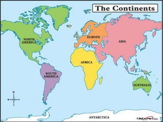
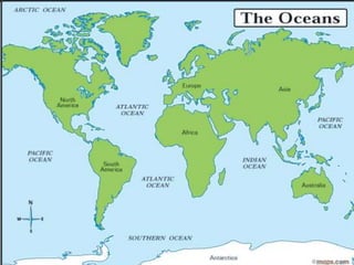
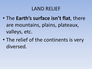
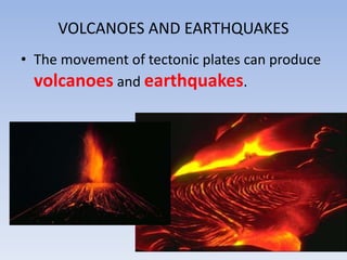
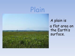
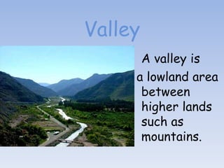
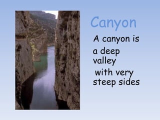
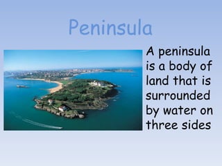
The document discusses the key physical features of Earth. It describes that Earth's surface is made up of both emerged and submerged lands, including six continents in the Northern Hemisphere and five oceans mostly in the Southern Hemisphere. It also explains that landforms like mountains and valleys are shaped by both internal forces within Earth and external erosion factors. Specific types of landforms like plains, plateaus, hills, mountains, valleys, canyons, peninsulas and islands are defined.
This is a presentation designed for 3rd graders. There were many videos embedded in this PPT, which you will not be able to view. It was also designed in kiosk mode which allows students to view a section at a time.
This is a PowerPoint Presentation by my second class at the Cape Fear Center for Inquiry in Wilmington, North Carolina. . This presentation reflects an inquiry continuum within the thematic unit of geography. The students began by recalling what they already knew about the seven continents and then asked questions to shape their research. Students also discussed what research sources would most helpful to answer their questions. After two sessions of small group work in the computer lab, students created PowerPoint slides to synthesize their findings. This was a challenging but age-appropriate project because students had to also work cooperatively in collaborative groups, use technology responsibly and implement design ideas to support their final product
Note: Some fonts have been altered since uploaded onto slideshare.
Geographic Regions of North America. This covers Virginia SOL USI.2b. The student will use maps, globes, photographs, pictures, or tables to
b) locate and describe the location of the geographic regions of North America: Coastal Plain, Appalachian Mountains, Canadian Shield, Interior Lowlands, Great Plains, Rocky Mountains, Basin and Range, and Coastal Range.
Lines of Latitude and Longitude – PowerPointYaryalitsa
PowerPoint on Lines of Latitude, Lines of Longitude, Climate Zones, Equinoxes, Solstices, The Three Norths, Prime Meridian, International Date Line, Greenwich Mean Time, Coordinated Universal Time.
Lines of Latitude and Longitude – Worksheet at:
http://www.slideshare.net/yaryalitsa/lines-of-latitude-and-longitude-worksheet
Different Kind of Landforms and Water forms.
I don't own any pictures and informations. This presentation is for Educational Purpose ONLY and compiled by Roiden Fernandez!
Follow me on twitter @roidenfredrich!
Operation “Blue Star” is the only event in the history of Independent India where the state went into war with its own people. Even after about 40 years it is not clear if it was culmination of states anger over people of the region, a political game of power or start of dictatorial chapter in the democratic setup.
The people of Punjab felt alienated from main stream due to denial of their just demands during a long democratic struggle since independence. As it happen all over the word, it led to militant struggle with great loss of lives of military, police and civilian personnel. Killing of Indira Gandhi and massacre of innocent Sikhs in Delhi and other India cities was also associated with this movement.
The Roman Empire A Historical Colossus.pdfkaushalkr1407
The Roman Empire, a vast and enduring power, stands as one of history's most remarkable civilizations, leaving an indelible imprint on the world. It emerged from the Roman Republic, transitioning into an imperial powerhouse under the leadership of Augustus Caesar in 27 BCE. This transformation marked the beginning of an era defined by unprecedented territorial expansion, architectural marvels, and profound cultural influence.
The empire's roots lie in the city of Rome, founded, according to legend, by Romulus in 753 BCE. Over centuries, Rome evolved from a small settlement to a formidable republic, characterized by a complex political system with elected officials and checks on power. However, internal strife, class conflicts, and military ambitions paved the way for the end of the Republic. Julius Caesar’s dictatorship and subsequent assassination in 44 BCE created a power vacuum, leading to a civil war. Octavian, later Augustus, emerged victorious, heralding the Roman Empire’s birth.
Under Augustus, the empire experienced the Pax Romana, a 200-year period of relative peace and stability. Augustus reformed the military, established efficient administrative systems, and initiated grand construction projects. The empire's borders expanded, encompassing territories from Britain to Egypt and from Spain to the Euphrates. Roman legions, renowned for their discipline and engineering prowess, secured and maintained these vast territories, building roads, fortifications, and cities that facilitated control and integration.
The Roman Empire’s society was hierarchical, with a rigid class system. At the top were the patricians, wealthy elites who held significant political power. Below them were the plebeians, free citizens with limited political influence, and the vast numbers of slaves who formed the backbone of the economy. The family unit was central, governed by the paterfamilias, the male head who held absolute authority.
Culturally, the Romans were eclectic, absorbing and adapting elements from the civilizations they encountered, particularly the Greeks. Roman art, literature, and philosophy reflected this synthesis, creating a rich cultural tapestry. Latin, the Roman language, became the lingua franca of the Western world, influencing numerous modern languages.
Roman architecture and engineering achievements were monumental. They perfected the arch, vault, and dome, constructing enduring structures like the Colosseum, Pantheon, and aqueducts. These engineering marvels not only showcased Roman ingenuity but also served practical purposes, from public entertainment to water supply.
Unit 8 - Information and Communication Technology (Paper I).pdfThiyagu K
This slides describes the basic concepts of ICT, basics of Email, Emerging Technology and Digital Initiatives in Education. This presentations aligns with the UGC Paper I syllabus.
Students, digital devices and success - Andreas Schleicher - 27 May 2024..pptxEduSkills OECD
Andreas Schleicher presents at the OECD webinar ‘Digital devices in schools: detrimental distraction or secret to success?’ on 27 May 2024. The presentation was based on findings from PISA 2022 results and the webinar helped launch the PISA in Focus ‘Managing screen time: How to protect and equip students against distraction’ https://www.oecd-ilibrary.org/education/managing-screen-time_7c225af4-en and the OECD Education Policy Perspective ‘Students, digital devices and success’ can be found here - https://oe.cd/il/5yV
Ethnobotany and Ethnopharmacology:
Ethnobotany in herbal drug evaluation,
Impact of Ethnobotany in traditional medicine,
New development in herbals,
Bio-prospecting tools for drug discovery,
Role of Ethnopharmacology in drug evaluation,
Reverse Pharmacology.
How to Create Map Views in the Odoo 17 ERPCeline George
The map views are useful for providing a geographical representation of data. They allow users to visualize and analyze the data in a more intuitive manner.
2. CONTINENTS AND OCEANS
On the Earth’s crust there are emerged and
submerged lands:
• Continents occupy 30% of the land surface
and are surrounded by oceans and seas. There
are six continents: Asia, America, Africa,
Antarctica, Europe and Australia.
• Most of the emerged land is in the northern
hemisphere.
3. CONTINENTS AND OCEANS
• Oceans are large masses of salt water. There
are five oceans: The Pacific Ocean, The
Atlantic Ocean, The Indian Ocean, The Arctic
Ocean and the Southern Ocean.
• Most oceans are in the southern hemisphere.
4.
5.
6. LAND RELIEF
• The Earth’s surface isn’t flat, there
are mountains, plains, plateaux,
valleys, etc.
• The relief of the continents is very
diversed.
7. • The relief is the result of the internal
forces of the Earth(plate movements,
volcanoes, earthquakes, etc.) and
external agents (wind, rain,
temperature, rivers, waves, ice... and
human-beings).