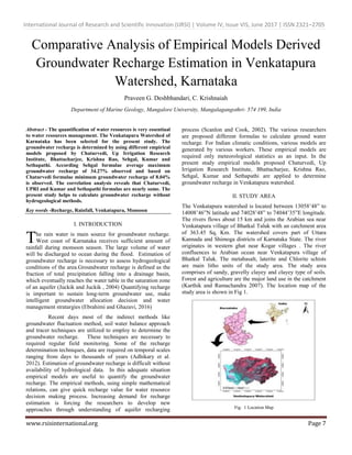
The quantification of water resources is very essentiaal
to water resources management. The Venkatapura Watershed of
Karnataka has been selected for the present study. The
groundwater recharge is determined by using different empirical
models proposed by Chaturvedi, Up Irrigation Research
Institute, Bhattacharjee, Krishna Rao, Sehgal, Kumar and
Sethapathi. According Sehgal formulae average maximum
groundwater recharge of 34.27% observed and based on
Chaturvedi formulae minimum groundwater recharge of 8.04%
is observed. The correlation analysis reveals that Chaturvedi,
UPRI and Kumar and Sethapathi formulas are nearly same. The
present study helps to calculate groundwater recharge without
hydrogeological methods.
Evaporation and Production Efficiency Modelling Using Fuzzy Linear RecurrenceAI Publications
The relationship between crop production and amount of evapotranspiration is very important to agronomists, engineers, economists, and water resources planners. These relationships are often determined using classical least square regression (LSR). However, one needs high amount of samples to determine probability distribution function. Linear regression also requires so many measurements to obtain the valid estimates of crop production function coefficients. In addition, deriving ET-yield regression for each crop and each district is usually expensive, since lysimetric experiments should be repeated for several years for each crop. The object of this study is to introduce a fuzzy linear regression as an alternative approach to statistical regression analysis in determining coefficients of ET- yield relations for each crop and each district with minimum data. The application of possibilistic regression has been examined with a case study. Two data set for winter wheat in Loss Plateau of China and North China Plain have been used. The current finding shows capability of possibilistic regression in estimation of crop yield in data shortage conditions.
Estimation of Annual Runoff in Indravati Sub Basin of Godavari River using St...AM Publications
Prediction of runoff from known rainfall is one of the major problems confronted by hydrologists. There is lack of availability of long period runoff records in large number of catchments in India. Investigators have proposed many empirical relationships for runoff estimation in different catchments based on limited data of parameters affecting runoff. These regional relationships are useful in planning of water resource projects. This study was carried out to obtain simple yet effective relationship for estimation of annual runoff in Indravati sub basin of Godavari river. Regression analysis was carried out using annual rainfall, annual runoff and average annual temperature data to develop empirical models for annual runoff estimation. GIS software was used for preparing maps for the study area and to extract the precipitation and temperature data available in grid format from IMD. The best suited empirical model is then selected as per statistical criteria with lower values of standard error, standard deviation, mean absolute deviation (MAD), root mean square error (RMSE) and higher values of R square and correlation coefficient. Statistical significance of selected empirical model was evaluated by paired t test, F test and P value at 95 % confidence level. The developed relationship is then compared with the existing Khosla and Inglis and DeSouza relationships. Outcome of this comparison produces encouraging inferences to suggest an effective regional relationship for annual runoff estimation in the Indravati sub basin of Godavari river in India.
Assessing Water Demand And Supply For Srinagar City (J&K) India, Under Chang...IJMER
The study holds significance keeping in view the global climatic concerns, which began
to cast their shadows on the climate of Jammu and Kashmir as well. In order to accomplish the
present study, WEAP (water evaluation and planning model) of Stockholm Environment Institute
was used. This model is a tool for integrated water resource management and planning like,
forecasting water demand, supply, inflows, outflows, water use, reuse, water quality, priority areas
and Hydropower generation, etc,. During the present study discharge data from 1979-2010 (past
thirty years) of our study rivers i.e., Dachigam Stream and Sindh Stream was used as supply to our
demand sites and also to find the impacts of changing climatic conditions over them. Due to
availability of data upto year 2010 only therefore the scenarios were generated from year 2011
onwards. The water demands for Srinagar i,e., irrigation demands for agriculture and water
supply demands for our domestic needs was analyzed, industrial demands were not analyzed as we
have negligible demands in this sector. The water supplied to our demand sites was mostly
contributed by our study rivers and a little demand was met by ground water. Data was collected
from various agencies like PHE Srinagar, Census data of 2011, Meteorology department etc. This
collected and generated data was given as input to the WEAP model. The model generated the
trends for discharge of our study rivers for next 15 years and at the same time also generated
scenarios calculating our demands and supplies for the future. The model results reveal that there
will be shortages in the requirements met in the urban water needs for some years like 2016, 2017,
2018 and 2020. The results generated from the model outputs will help us in predicting whether
our water resources are going to suffice our growing water needs or not in future. The results will
help in drafting policies for future regarding water supplies and demands under changing climatic
scenarios.
Determination of homogenous regions in the Tensift basin (Morocco).IJERA Editor
The aim of this study is to determine homogenous region in the Tensift basin within which the hydrological behavior is similar. In order to do this we used two methods: The Principal components analysis on the monthly precipitation registered at the 23 rainfall stations. This resulted in setting apart 4 groups of stations. The second method is analysis of land use map, geological map, pedagogical map, vegetation map and slope map of the studied area. This method allowed us to delineate 4 homogenous areas. The two methods yielded complementary results and the superposition of groups and regions obtained allowed us to retain 4 homogenous regions corresponding to 3 groups of stations.
Assessment of two Methods to study Precipitation PredictionAI Publications
Presipitation analysis plays an important role in hydrological studies. In this study, using 50 years of rainfall data and ARIMA model, critical areas of Iran were determined. For this purpose, annual rainfall data of 112 different synoptic stations in Iran were gathered. To summarize, it could be concluded that: ARIMA model was an appropriate tool to forecast annual rainfall. According to obtained results from relative error, five stations were in critical condition. At 45 stations accrued rainfalls with amounts of less than half of average in the 50-year period. Therefore, in these 45 areas, chance of drought is more than other areas of Iran.
Empirical equations for flood analysis in arid zonesAmro Elfeki
Mohammad Albishi, Jarbou Bahrawi, and Amro Elfeki (2016). Empirical Equations for Flood Analysis in Arid Zones. Published in the book of abstracts at IWC 2016 International Water Conference 2016 on Water Resources in Arid Areas: the Way Forward.
Rainfall runoff is one of the important hydrological variables in determining land
and water resources application. Curve Number method is widely used and efficient
method to estimate the infiltration characteristic of the watershed in accordance with
the land use/land cover property and soil property. In this study to estimate the
rainfall runoff modeling in this study area with an area of 152.81 sq km using Soil
Conservation Service Curve Number (SCS-CN) method and GIS. The estimated
amount average annual rainfall 1322.29mm from 1999 to 2013.The runoff varied
from 285 mm–4053mm, which is corresponds to 61.6% of annual average rainfall of
Thiruvalur district. These details are used for better watershed management and
conservation purpose.
An Attempt To Use Interpolation to Predict Rainfall Intensities tor Crash Ana...IJMERJOURNAL
ABSTRACT: This study uses different interpolation techniques to predict rainfall intensity at locationsthat are not directly located near a rainfall gauges. The goal of being able to interpolate the rainfall intensity is to study its impact on traffic crashes. To perform the study, a collection of rainfall gauges in Alabama were used as subject locations where rainfall intensity was predicted from surrounding gauges, while also providing validation data to compare the predictions. Essentially, the actual rainfall intensities at existing gauges were interpolated using nearby gauges and the results were analyzed.The interpolation techniques used in the study included proximal, averaging and a distance weighted average. The results of the study indicated that none of the interpolation methodologies were sufficient to accurately predict the rainfall intensity values any significant distance from the actual gauges.
Long-term observed Precipitation Trends in Arid and Semi-arid Lands, Baringo ...Premier Publishers
The research was conducted to validate the pastoralists’ and agro-pastoralists’ claim that there has been an increasingly variable and changing climate in the study area. The station average and Theissen polygon methods were used to estimate the mean areal precipitation of the small (Mogotio and Baringo South Sub-counties) and the large area (Baringo County), respectively. The aim of the current study is to analyse rainfall time series over long term observed precipitation and a wide area, detecting potential trends and assessing their significance. Monthly precipitation data for the period 1974-2003 from six weather stations, located mainly in Mogotio and Baringo South sub-counties and covering 3906km2 were used in the analysis. The data were quality controlled to ensure no missing data and any inconsistencies. Linear regression analysis of the database highlighted that; the trends were predominantly negative, both where the average and Theissen polygon methods were used and over the whole reference period. The negative trends are not significant. This finding implies that the study area has been suffering a precipitation decrease especially in the period under review.
As basic data, the reliability of precipitation data makes a significant impact on many results of environmental applications. In order to obtain spatially distributed precipitation data, measured points are interpolated. There are many spatial interpolation schemes, but none of them can perform best in all cases. So criteria of precision evaluation are established. This study aims to find an optimal interpolation scheme for rainfall in Ningxia. The study area is located in northwest China. Meteorological stations distribute at a low density here. Six interpolation methods have been tested after exploring data. Cross-validation was used as the criterion to evaluate the accuracy of various methods. The best results were obtained by cokriging with elevation as the second variable, while the inverse distance weighting (IDW) preform worst. Three types of model in cokriging were compared, and Gaussian model is the best.
การนำเสนอบทความวิชาการในการประชุมวิชาการ ICUE 2020 on Energy, Environment, and Climate Change International Conference
ระหว่างวันที่ 20-22 ตุลาคม 2563 ในรูปแบบออนไลน์
หัวข้อ Meteorological Drought Hazard Assessment under Future Climate Change Prediction for Agriculture Area in Songkhram River Basin, Thailand
CLIMATE CHANGE AND ITS IMPACT ON GROUNDWATER TABLE FLUCTUATION IN PRECAMBRIAN...IAEME Publication
The study area falls within the semiarid region and frequently facing water scarcity problems. Rain is a form of precipitation, snow, sleet, hail and dew. The precipitation occurs when separate drops of waterfalls on the earth’s surface from clouds. Not all rain reaches the surface, however; some evaporates while falling through dry air, a type of precipitation called Virga. The precipitated water percolates to deeper zones to be stored as groundwater. The present study generates the primary data to map the groundwater table fluctuation in hard rock terrain of Chitradurga District
through Geomatics technique. Efforts have been made to evaluate a total of 20 representative rain gauge station samples and analyzed the season rainfall variation over a period of 31 years (1981- 2011). 47 representative well samples are collected to study the season-wise groundwater fluctuation of about 11 years (2000-2011). Rain gauge stations are plotted on a base map with their respective amount of rainfall.
การนำเสนอบทความวิชาการในการประชุมวิชาการวิศวกรรมโยธาแห่งชาติครั้ง 26 กลุ่มวิศวกรรมแหล่งน้ำ วิศวกรรมโยธากับการศึกษา วิศวกรรมวัสดุก่อสร้าง วันที่ 24-25 มิถุนายน 2564 ในรูปแบบออนไลน์
หัวข้อ Assessment of Future Drought Hazard to Agricultural Area in Mun River Basin, Thailand
IJRET : International Journal of Research in Engineering and Technology is an international peer reviewed, online journal published by eSAT Publishing House for the enhancement of research in various disciplines of Engineering and Technology. The aim and scope of the journal is to provide an academic medium and an important reference for the advancement and dissemination of research results that support high-level learning, teaching and research in the fields of Engineering and Technology. We bring together Scientists, Academician, Field Engineers, Scholars and Students of related fields of Engineering and Technology
Application of mathematical modelling in rainfall forcast a csae study in...eSAT Journals
Abstract Malaysia receives rainfall from 2000 mm to 4000 mm annually where it is greatly influenced by two monsoon periods in November to March and May to September. The state of Sarawak is well known for its long and wide rivers. Numerous activities such as commercial, industrial and residential can always be found in the vicinity of the rivers. The activities have started since decades ago and still continue to grow and spatially expanding through times providing incomes ranging from small farmers to the largest corporations. Unfortunately, these areas are expected to experience frequent flood events as well as possible receding water level in rivers based on the findings of previous studies. If the projections are accurate, the productivity of these activities will be reduced, hence, in a longer term may affect the economy of the state as whole as well. Therefore, there is an urgent need for existing knowledge on rainfall behavior to be revised as effects of climate change with the intention that the state can fully utilize the favorable conditions and make scientific based decisions in the future. Recent study reveals that the Fourier series (FS), has the ability to simulate long-term rainfall up to 300 years is viewed as an important finding in the study of rainfall forecast. Long-term rainfall forecasting is viewed to be beneficial to the state of Sarawak in its future planning in various sectors such as water supply, flood mitigation, river transportation as well as agriculture. The main goal of the study is to apply a mathematical modeling in rainfall forecasting for the Sungai Sarawak basin. Data from eight rain gauge stations was analyzed and prepared for missing data, consistency check and adequacy of number of stations. Simple statistical analysis was conducted on the data such as maximum, minimum, mean and standard deviation. 27 years of annual rainfall data were simulated with the Fourier Series equation using spreadsheet. Hence, the result was compared with the Fitting N-term Harmonic Series. The model result reveals that the Fourier Series has the ability to simulate the observed data by being able to describe the rainfall pattern and there is a reasonable relationship between the simulation and observed data with p-value of 0.93. Keywords: Fourier series, Mathematical
ASSESSING THE EFFECTS OF SPATIAL INTERPOLATION OF RAINFALL ON THE STREAMFLOW ...civej
Precipitation within a river basin varies spatially and temporally and hence, is the most relevant input for
hydrologic modelling. Various interpolation methods exist to distribute rainfall spatially within a basin.
The sparse distribution of raingauge stations within a river basin and the differences in interpolation
methods can potentially impact the streamflow simulated using a hydrologic model. The present study
focuses on assessing the effect of spatial interpolation of rainfall using Theissen polygon, Inverse distance
weighted (IDW) method and Ordinary Kriging on the streamflow simulated using a physically based
spatially distributed model-SHETRAN in Vamanapuram river basin in Southern Kerala, India. The
SHETRAN model in the present study utilises rainfall data from the available rain gauge stations within the
basin and potential evapo-transpiration calculated using Penman-Monteith method, along with other input
parameters like soil and landuse. Four years of rainfall and evapo-transpiration data on a daily scale is
used for model calibration and one year data for validation. The performance of the different spatial
interpolation methods were assessed based on the Mean Annual flow and statistical parameters like NashSutcliffe
Efficiency, coefficient of determination. The ordinary kriging and IDW methods were found to be
satisfactory in the spatial interpolation of rainfall.
Analysis of Monthly Rainfall Trend over the Mahanadi Basin in Kesinga StationIJLT EMAS
Climatic changes is uncertain in nature and other
changes are not expected to be uniform, rather there may be
dramatic regional differences. Considerable effort should be given
to understand change in climate at the regional level. Here we had
conducted the study to establish the rainfall trends in the Tel river
of Kesinga and also to provide the evidence of climate change by
analyzing available rainfall record for 11years period from 2003 to
2013. Records of monthly rainfall were obtained from the CWC
station at Kesinga for analysis. Graphs were constructed to
illustrate the changing trends within the months of the study area.
From the graphs the highest and lowest amount of rainfall was
obtainedand the variation in rainfall was studied. The mean,
median, standard deviation, variance of rainfall data of each month
was obtained to know the variation in 11 years of data. Trend
analysis is parametric type, i.e. linear regression analysis revealed
positive and negative trend in some months.
Data Preparation for Assessing Impact of Climate Change on Groundwater RechargeAM Publications
Climate change is a change in the statistical properties of the climate system when considered over long
periods of time. It significantly affects the various components of hydrological cycle like temperature, precipitation,
evapotranspiration and infiltration. All these components together affect the rate of groundwater recharge. So
understanding the effects of climate change on groundwater recharge is the need of time for the management of
groundwater resources. This paper presents the data preparation initiatives and a suitable methodology that can be
used to characterize the effect of climate change on groundwater recharge. The method is based on the hydrologic
model Visual HELP which can be used to estimate potential groundwater recharge at the regional scale. The success
of Modeling depends on the accuracy of data and the mode of collecting the data. Therefore, identifying the data
needs of a particular modeling study, collection/monitoring of required data and preparation of data set form an
integral part of any groundwater modeling exercise. The main objective of this paper is to describe the exact data
required and its preparation to simulate the groundwater recharge using HELP Model Software for Yavatmal as a
study area situated in Maharashtra state, India. The impact of climate change as a pilot study is modeled by using
computer software HELP (Hydrologic Evaluation of Landfill Performance). The initiatives for data preparation
presented herein may be useful to the researchers in this field.
Adequate knowledge about the hydrology is very much required for the proper planning and management of water resources in an area. Rainfall and runoff are the important constituents in determining the hydrology of an area to determine the water management strategies. SCS- CN method is a widely used method for the calculation of surface runoff considering the land use pattern, soil type and antecedent moisture condition. In the present study runoff of the Palar watershed, Karnataka state, South India has been calculated using the SCS-CN method. The watershed consists of a total area of 2872.357 km2. The maximum rainfall of 1231.67 mm in the year 2005 and a minimum of 418.7 mm in the year 2003. The average annual runoff is calculated as 218.26 mm and 626.91MCM. The rainfall- runoff correlation value is 0.8253. The study results can be effectively coordinated for the watershed management activities.
A study on comparision of runoff estimated by Empirical formulae with Measure...Ahmed Ali S D
MAIN PUPOSE OF THIS PPT PRESENTATION IS TO SELECT SIUTABLE DISCHARGE FORMULA FOR A RIVER BASIN TO ESTIMATE RUNOFF ONLY BY USING PRECIPITATION DATA ONLY. IF WE KNOW RAINFALL DATA WE EASILY ESTIMATE FUTURE RUNOFF ALSO.
Comparison of Spatial Interpolation Techniques - A Case Study of Anantnag Dis...IJMER
Groundwater is used for a variety of purposes, including irrigation, industrial, drinking, and manufacturing. Assessment and mapping of quality of groundwater is an important because the physical and chemical characteristics of groundwater determine its suitability for agricultural, industrial and domestic usages. The present study area i.e, District Anantnag lies in southern part of Jammu and Kashmir and is characterized by undulating topography, rugged mountains. The habitants of the study
area mainly depend on ground water resources viz; springs and tube wells. The present study attempts to
explore the best spatial interpolation technique that will best represent the actual ground water quality of
district anantnag. In the present study various maps representing various physio-chemcial properties of
ground water quality were generated using spatial interpolation techniques viz; Inverse Distance Weighted (IDW) and Nearest Neighbor (NN). Out of total 92 ground water samples, 8 points were preserved for cross validation between the two interpolation techniques using Root Mean Square Error (RMSE) test. Finally it can be conclude that IDW is the most preferable technique for spatial interpolation measurement of ground water quality data.
Comparison of Spatial Interpolation Techniques - A Case Study of Anantnag Di...IJMER
Groundwater is used for a variety of purposes, including irrigation, industrial, drinking, and
manufacturing. Assessment and mapping of quality of groundwater is an important because the physical
and chemical characteristics of groundwater determine its suitability for agricultural, industrial and
domestic usages. The present study area i.e, District Anantnag lies in southern part of Jammu and
Kashmir and is characterized by undulating topography, rugged mountains. The habitants of the study
area mainly depend on ground water resources viz; springs and tube wells. The present study attempts to
explore the best spatial interpolation technique that will best represent the actual ground water quality of
district anantnag. In the present study various maps representing various physio-chemcial properties of
ground water quality were generated using spatial interpolation techniques viz; Inverse Distance
Weighted (IDW) and Nearest Neighbor (NN). Out of total 92 ground water samples, 8 points were
preserved for cross validation between the two interpolation techniques using Root Mean Square Error
(RMSE) test. Finally it can be conclude that IDW is the most preferable technique for spatial
interpolation measurement of ground water quality data.
EVALUATION OF GROUNDWATER QUALITY OF VAIPPAR BASIN, TAMIL NADU, INDIA: A GEOI...SagarChougule11
The Vaippar Basin, one of the important basins of Tamil Nadu is located between 9° 0' 05" & 9° 44' 56" N latitudes and 77° 23' 25" & 78° 17' 02" E longitudes with an area of 5339 sq.km. Groundwater samples were collected from 91 different locations in Vaippar basin, Tamil Nadu, India. Groundwater quality data for the period of 30 years (1983 to 2013) of both pre-monsoon and post-monsoon periods were used to analyze the groundwater quality aspects of the Vaippar basin.
Quantitative evaluation and analysis of morphometric parameters derived from ...AM Publications
GIS has become a key source to understand the hydrological conditions of watersheds for the last few decades. Arc Hydro tool of ArcGIS has been proven its role in the automated extraction of drainage network and morphometric analysis from DEMs. The delineation of drainage network can be done either manually from topographic sheets or derived from Digital Elevation Model (DEM) data by means of computational methods. In the present work, ASTER DEM has been incurred to extract drainage network with the aid of Arc hydro tool. The Vaishali River basin of Madhya Pradesh has been taken as the study area. This study has been done primarily based on a geo-spatial software ARC GIS in which ARC HYDRO a tool has been used extensively. The quantitative evaluation and analysis of about twenty morphometric parameters has been done based on the linear, areal and relief aspects. The analysis has revealed that the Vaishali River basin is a fifth order basin showing dendritic drainage pattern with drainage density of 0.40 per km and stream frequency of 0.08 per km2. Low drainage density indicates the basin has not been much affected by structural disturbances while drainage frequency and very coarse drainage texture specifies low relief and porous, permeable rocks beneath the ground surface. The form factor, circularity ratio and elongated ratio suggest the basin shape as elongated. The area has low to moderate relief and slopes displays moderate relief ratios. It is concluded that this technique is not only reduces time but also provides valuable results which are very helpful for watershed management studies.
Teacher’s Accomplishment Level of The Components of an E-Learning Module: A B...RSIS International
This study determined the extent to which teachers in a private institution in La Trinidad, Benguet, Philippines have accomplished the essential components of an E-learning module, and identified the factors that influenced their level of accomplishment of these components. This study used mixed method explanatory sequential design. Total enumeration was used to determine the population of respondents who were full-time tertiary teachers. Out of the thirty-six full-time teachers, twenty-eight teachers responded and answered the self-assessment survey questionnaire for the quantitative phase, while seven of them who were selected using purposive sampling were interviewed for the qualitative part. Descriptive statistics using weighted mean was used to analyze quantitative data while descriptive approach using thematic analysis for the qualitative data. Quantitative descriptive analysis revealed that the teachers’ overall accomplishment level of the criteria for a quality E-learning module is partial/moderate (2.68 overall weighted mean/WM). Specifically, the teachers partially accomplished the following components of the E-learning module: instructional design (2.84 WM); communication, interaction, and collaboration (2.85 WM); student evaluation and assessment (2.89 WM); instructional materials and technologies (2.75 WM); and accessibility (2.66 WM) while slightly accomplished the components: learner support and resources (2.21 WM), and course evaluation (2.24 WM). For the qualitative descriptive inquiry, absence of capacity-building training in making E-learning module; lack of awareness of the school services, learner support, and resources sites; lack of time; lack of systemic approach to developing an online module; non-consistency of instructions; and amotivation and lack of enthusiasm emerged as factors that influence the teachers’ level of accomplishment of the parts of an E-learning module. The results show that the E-learning modules have fallen short of strict quality standards attributable to certain dire circumstances. This study thus recommends that the institution may adopt or develop its online module criteria to guide the teachers as well as the institution in writing or designing their online modules, and may conduct training in E-module design for teachers.
Development Administration and the Challenges of Neo-liberal Reforms in the E...RSIS International
The quest of every nation state is to attract, sustain and fast-track growth and development in all ramifications. The Nigerian state between 1960 and 2020 has experienced an unabated expansion of universities. Ironically, the war against illiteracy is yet to be won, despite the experimentation of different western developmental ideologies in the Nigerian educational system. The study examined the contributions of development administration in the Nigerian educational sector as well as ascertained if the current neo-liberal reform has aided the expansion or retrogression of the educational sector most especially, the university sub-sector in Nigeria. The theoretical framework of the study was anchored on the post-colonial Nigerian state theory. Methodologically, the study strictly utilized the documentary method and data were sourced through the secondary sources and analyzed in content. The study found that the experimentation of western development ideologies in Nigeria actually aided the expansion of the universities but undermined the realization of free, quality and accessible university education for all and sundry. The study recommended among others: the applications of the action plan of Professor Okonjo as regards creating a universal tertiary education for all Nigerians and sustainably financing it.
The Nexus of Street Trading and Juvenile Delinquency: A Study of Chanchaga Lo...RSIS International
I. INTRODUCTION
Globally, the number of working children has been decreasing around the world in recent years, but child labour has continued to be a widespread problem today, especially in developing countries (Paola, Viviana, Flavia & Furio2007). International Programme on Elimination of Child Labour (IPEC 2016) reported that between 2012 to 2016, about 182 million children in the developing world aged 5-14 years were engaged in work. Against this background, governments, international organizations, and non-governmental organizations (NGOs) have focused their efforts on tackling in particular the worst forms of child labour such as forced and bonded labour, which put children in physically and mentally harmful working conditions (Bunnak 2007).
Determination of Bacteriological and Physiochemical Properties of Som-Breiro ...RSIS International
The study seeks to examine the Bacteriological and
physiochemical properties of Sambrero River in Ahoada East
Local Government Area of Rivers State. Three (3) points were
sampled from different locations designated as location (L1)
location (L2) and location (L3) respectively, samples were
collected in 0.1m of Sterile containers and were transported to
the laboratory for immediate analysis. Ten (10) physiochemical,
three (3) heavy metal sand three microbiological parameters
were observed. Data was analyzed using standard methods
(ALPHA, 1998) 20th edition and Ms-Excel version 2013 software.
The result showed little variation in physiochemical parameters
which are in line with World Health Organization (WHO)
standard of potable water but shows much variation in
microbiological parameters which are not in line with WHO
standard, thereby making the water not wholesome and not
potable for consumption except after proper treatment of the
water. The work therefore recommends that members of Ekpena
Community should ensure basic water treatment such as boiling
and chlorination before consumption.
Power and Delay Analysis of Logic Circuits Using Reversible GatesRSIS International
This paper determines the propagation delay and on
chip power consumed by each basic and universal gates and
basic arithmetic functions designed using existing reversible
gates through VHDL. Hence a designer can choose the best
reversible gates to use for any logic circuit design. The paper
does a look up table analysis of truth tables of the reversible
gates to find the occurrence of the AND OR, NAND, NOR and
basic arithmetic functions, useful to build complex combinational
digital logic circuits.
Innovative ICT Solutions and Entrepreneurship Development in Rural Area Such ...RSIS International
The use of internet and information communication
technology (ICT) infrastructures is an essential aspect of
learning, this is why a lot of information on entrepreneurship
career choices are available online. However, the emerging
growth in the use of information and communication
technologies and services towards entrepreneurship development
is a challenge for efficient information dissemination and
learning especially in rural areas. This paper pointed out an area
in which MCIU can use Information and Communication
Technology (ICT) resources/infrastructure it possess for
entrepreneurship development and poverty alleviation in its
community. Thereby, encouraging social and economic growth,
and overcome the gap between urban and rural areas
entrepreneurship development. An online learning platform,
using video may contribute greatly in rural entrepreneurship
development such as MCIU community. Some examples of some
programmes like learning make over, headgear tying, bead
making, cake designing, etc online for a period of 4 to 6weeks
Indigenous Agricultural Knowledge and the Sustenance of Local Livelihood Stra...RSIS International
Natural disasters in most parts of the world have
resorted to many fatalities, forced migration and involuntary
resettlement of the affected population. Lake Nyos Gas Disaster
of 1986 which killed about 1,746 people and led to forced
migration of over 15,000 affected people and the subsequent
resettlement of survivors in resettlement camps in near by
administrative sub-divisions in the North West Region of
Cameroon is one of such natural catastrophies. The paper
evaluates the use of Indigenous Agricultural Knowledge (IAK) in
agriculture and how it has helped to sustain the livelihood of this
environmentally traumatized resettled population. The study
sampled two of these resettlement villages (Buabua and Kimbi)
to access Indigenous Agricultural Knowledge (IAK) and the
sustenance of local livelihood strategies. Field campaigns
including the administration of semi-structured questionnaires
and focus group discussions (FGDs) facilitated the collection of
data on IAK practices and how this knowledge helps in
sustaining local livelihoods. A total of 24 Indigenous Agricultural
Knowledge (IAK) were identified, with 54.16% of them used in
crop cultivation, and 45.83% in livestock farming including the
raising of small ruminants, poultry and piggery production. IAK
shows successful results after being applied as there is increased
crop and livestock yields. The use of IAK in agriculture has led
to sustainable and efficient land use within the study area.
Despite the rising use of IAK and potential benefits in
agriculture and the sustenance of local livelihoods in Buabua and
Kimbi, survivors still express a strong desire to return to the
former disaster zone. The underlying reasons behind this phobia
is mainly small land sizes ranging from 30-50 square metres that
were allocated to households for both crop cultivation and
grazing, and the fact that the limits between grazing and crop
land are not clearly demarcated. Prospects for agricultural
expansion within the area are therefore slim and need to be
addressed
Wireless radio signal drop due to foliage in illuba bore zone ethiopiaRSIS International
The exponential growth in energy utilization &
consumption in cellular network by the user devices and by
telecom equipment has imposed critical problemsbecause of
adaptation of high range frequency in available spectrum (Ultra
High Frequency-UHF) by government and technology.The other
reason for more power consumption is extensive applications of
mobile data services to video streaming, surveillance, internet
surfing and healthcare monitoring.Other important causes of
energy consumption which has been recognized are powerhungry
processors, poor design of power amplifiers etc. Presence
of different species of foliage in hilly area increases signal
attenuation, consequently in order to maintain the threshold
value of signal, the power is increased. The recent researches
predict that the data traffic is being increased by several-fold
every year. Under such predictions, energy expenditure at its
control is a major challenging task for telecom companies and
for research communities. This paper studies the actual signal
intensity drop because of irregular nature of terrestrial pattern
and foliage in Illuba Bore zone, from theoretical perspective as
well as practical point of view.
The Bridging Process: Filipino Teachers’ View on Mother TongueRSIS International
This paper recognized that teachers play the main
element in the success of the new language policy, the Mother
Tongue-Based Multilingual Education (MTB-MLE) in the
Philippines. Their views as implementer on this approach are
essential in the attainment of the MTB-MLE objectives. In this
descriptive paper, the authors report a comprehensive account of
the 35 teachers’ perception on the efficiency and effectiveness of
MTB approach in teaching at Malvar Central School, Batangas,
Philippines for the school year 2016-2017. Using adopted
questionnaire, needed data were gathered and statistically
treated. The study found out that the respondents moderately
perceived mother tongue- based approach as effective and
efficient in achieving learning goals. The implications of these
findings are discussed within the theoretical and practical issues
surrounding the use of mother tongue-based in the Philippines
Optimization of tungsten inert gas welding on 6063 aluminum alloy on taguchi ...RSIS International
In this paper, the Taguchi method is used for the
Optimization of Tungsten Inert Gas Welding on 6063
Aluminum Alloy. The Taguchi method L27 is used to
optimize the pulsed TIG welding process parameters of 6063
aluminum alloy weldments for maximizing the mechanical
properties. Analysis of Variance is used to find the impact of
individual factors. Then the optimal parameters of the TIG
welding process is determined and the experimental results
illustrate the proposed approach.
Investigation of mechanical properties of carbidic ductile cast ironRSIS International
The objective of the present work is to increase the wear resistance for long life of applications. It is found that increase in the carbides in an alloy which resulted in to enhancement in hardness and wear resistance. The wear resistance was evaluated by testing in accordance with ASTE International Committee G-99 Standard. An improved performance of wear resistanceis obtained by increasing the content of chromium in the carbidic ductile cast iron. The results are discussed based on the influence of chromium content on the casting.
Six Sigma Methods and Formulas for Successful Quality ManagementRSIS International
This paper is about the five phases of Six Sigma which are Define, Measure, Analyze, Improve& Control. The methods used in each phase are discussed in detail and the various tests used in Analyze Phase of Six Sigma are given; Six Sigma can be implemented in an organization by using the methods and formulas used in each phase combined with the help of Statistical Software Minitab 18.
Task Performance Analysis in Virtual Cloud EnvironmentRSIS International
Cloud computing based applications are beneficial for
businesses of all sizes and industries as they don’t have to invest
a huge amount on initial setup. This way, businesses can opt for
Cloud services and can implement innovative ideas. But
evaluating the performance of provisioning (e.g. CPU scheduling
and resource allocation) policies in a real Cloud computing
environment for different application techniques is challenging
because clouds show dynamic demands, workloads, supply
patterns, VM sizes, and resources (hardware, software, and
network). User’s requests and services requirements are
heterogeneous and dynamic. Applications models have
unpredictable performance, workloads, and dynamic scaling
requirements. So a demand for a Simulation toolkit for Cloud is
there. Cloudsim is self-contained simulation framework that
provides simulation and modeling of Cloud-based application in
lesser time with lesser efforts. In this paper we tried to simulate
the task performance of a cloudlet using one data center, one
VM. We also developed a Graphical User Interface to
dynamically change the simulation parameters and show
simulation results.
Design and Fabrication of Manually Operated Wood Sawing Machine: Save Electri...RSIS International
In India power cut is big problem also having many
remote places where electricity not reached and that will affect
many small scale business and ongoing work, like Carpentry,
ongoing work got stop because of power cut. To overcome this
problem manually operated economical; conceptual model of a
machine which would be capable of performing different
operation like sawing/cutting and grinding without use of power
i.e. wood working machine is introduced.
In this paper, design concept and fabrication of manually
operated wood sawing/cutting machine is explained. It is
designed and fabricated so portable that it can be move and used
at various places. It is used for sawing/cutting of wood, plywood,
thin metals (<=2mm), and pvc pipes. The material can be cut
without any external energy like fuel or current. As machine uses
no electric power and fuel, this will help to maintain green
environment. The observations show that power required for
pedaling is well below the capacity of an average healthy human
being.
Effect of Surface Treatment on Settlement of Coir Mat Reinforced SandRSIS International
Employment in rural areas is generated when byproduct
from the natural materials is used in construction
industry. The extent of usage of coir fibres in construction
industry is restricted by the fact that it is biodegradable. Though
use of natural materials such as coir fibers is well established. In
this view, the objective the present study is to surface treat the
coir mats, making it hydrophobic. Model footing tests using
model footing of 50mm diameter resting on Surface treated coir
mat of different opening size were conducted. The results
indicate that the surface treatment of coir products is beneficial
in increasing the strength of reinforced soil when compared with
untreated coir mats
Augmentation of Customer’s Profile Dataset Using Genetic AlgorithmRSIS International
Data is the lifeblood of all type of business. Clean,
accurate and complete data is the prerequisite for the decisionmaking
in business process. Data is one of the most valuable
assets for any organization. It is immensely important that the
business focus on the quality of their data as it can help in
increasing the business performance by improving efficiencies,
streamlining operations and consolidating data sources. Good
quality data helps to improve and simplify processes, eliminate
time-consuming rework and externally to enhance a user’s
experience, further translating it to significant financial and
operational benefits [1] [2]. All organizations/ businesses strive to
retain their existing customers and gain new ones. Accurate data
enables the business to improve the customer experience. Data
augmentation adds value to base data by enhancing information
derived from the existing source. Data augmentation can help
reduce the manual intervention required to develop meaningful
information and insight of business data, as well as significantly
enhance data quality. Hence the business can provide unique
customer experience and deliver above and beyond their
expectations. The Data Augmentation is immensely important as
it helps in improving the overall productivity of the business. It
is also important in making the most accurate and relevant
information available quickly for decision making.
This work focuses on augmentation of the customer
dataset using Genetic Algorithm(GA). These augmented data are
used for the purpose of customer behavioral analysis. The data
set consists of the different factors inherent in each situation of
the customer to understand the market strategy. This behavioral
data is used in the earlier work of analyzing the data [13]. It is
found that collecting a very large amount of such data manually
is a very cumbersome process. It is inferred from the earlier
work [13] that the more number of data may give accurate
result. Hence it is decided to enrich the dataset by using Genetic
Algorithm.
System Development for Verification of General Purpose Input OutputRSIS International
In SoC no. of IP block inside it depends upon specific
application, increase in the Ip block increases no. of digital
control lines causes increase in the size of the chip. GPIO helps
internal IP blocks to share digital control lines using MUX and
avoids additional circuitry. Since design productivity cannot
follow the pace of nanoelectronics technology innovation, it has
been required to develop various design methodologies to
overcome this gap. In system level design, various design
methodologies such as IP reuse, automation of platform
integration and verification process have been proposed. GPIO
configuration register decides in which mode system has to work
GPIO has four modes i.e input, output, functional, interrupt. As
per operation particular mode is selected and the operation get
performed. Devices with pin scarcity like integrated circuits such
as system-on-a-chip, embedded and custom hardware, and
programmable logic devices cannot compromise with size can
perform well without additional digital control line circuitry.
De-noising of Fetal ECG for Fetal Heart Rate Calculation and Variability Anal...RSIS International
Fetal monitoring is the way of checking the condition
of unborn baby during labor and delivery by continuously
monitoring his or her heart rate. A normal fetal heart rate (FHR)
can reassure safe birth of the baby. Fetal monitoring techniques
are broadly classified into invasive and non-invasive techniques.
Non-invasive techniques are involves monitoring the fetus
through mother’s abdominal region. This can be done in all
gestation weeks and during the delivery also. Abdominal ECG
(AECG) is a composite ECG signal containing both mother’s as
well as fetal ECG. This paper presents an efficient technique to
extract FECG from abdominal ECG. A modified Pan Tompkin’s
method is employed for the QRS detection. It involves series of
filters and methods like band pass filter, derivative filter,
squaring, integration and adaptive thresholding. Further heart
rate of fetus and mother is calculated and heart rate variability
analysis is done using detected R-peaks. The algorithm is tested
on 5 different non-invasively recorded abdominal and direct
FECG signals taken from MIT PhysioNet database and the
results are obtained using MATLAB software. The performance
of the QRS detector is evaluated using parameters like
Sensitivity and Positive Prediction.
A finite element modelling of composite plate with
integrated piezoelectric layers, acting as sensor/actuator, for
active vibration control is presented in this paper. The
displacement feedback (DF) and direct velocity feedback (DVF)
controls are integrated into the FE software ANSYS to perform
closed loop analysis for vibration control. A smart laminated
composite beam with different layup configurations under free
and forced vibration condition is studied and the results shows
suppression of vibration achieved successfully in both DF and
DVF controls.
Cosmetic shop management system project report.pdfKamal Acharya
Buying new cosmetic products is difficult. It can even be scary for those who have sensitive skin and are prone to skin trouble. The information needed to alleviate this problem is on the back of each product, but it's thought to interpret those ingredient lists unless you have a background in chemistry.
Instead of buying and hoping for the best, we can use data science to help us predict which products may be good fits for us. It includes various function programs to do the above mentioned tasks.
Data file handling has been effectively used in the program.
The automated cosmetic shop management system should deal with the automation of general workflow and administration process of the shop. The main processes of the system focus on customer's request where the system is able to search the most appropriate products and deliver it to the customers. It should help the employees to quickly identify the list of cosmetic product that have reached the minimum quantity and also keep a track of expired date for each cosmetic product. It should help the employees to find the rack number in which the product is placed.It is also Faster and more efficient way.
Final project report on grocery store management system..pdfKamal Acharya
In today’s fast-changing business environment, it’s extremely important to be able to respond to client needs in the most effective and timely manner. If your customers wish to see your business online and have instant access to your products or services.
Online Grocery Store is an e-commerce website, which retails various grocery products. This project allows viewing various products available enables registered users to purchase desired products instantly using Paytm, UPI payment processor (Instant Pay) and also can place order by using Cash on Delivery (Pay Later) option. This project provides an easy access to Administrators and Managers to view orders placed using Pay Later and Instant Pay options.
In order to develop an e-commerce website, a number of Technologies must be studied and understood. These include multi-tiered architecture, server and client-side scripting techniques, implementation technologies, programming language (such as PHP, HTML, CSS, JavaScript) and MySQL relational databases. This is a project with the objective to develop a basic website where a consumer is provided with a shopping cart website and also to know about the technologies used to develop such a website.
This document will discuss each of the underlying technologies to create and implement an e- commerce website.
Overview of the fundamental roles in Hydropower generation and the components involved in wider Electrical Engineering.
This paper presents the design and construction of hydroelectric dams from the hydrologist’s survey of the valley before construction, all aspects and involved disciplines, fluid dynamics, structural engineering, generation and mains frequency regulation to the very transmission of power through the network in the United Kingdom.
Author: Robbie Edward Sayers
Collaborators and co editors: Charlie Sims and Connor Healey.
(C) 2024 Robbie E. Sayers
About
Indigenized remote control interface card suitable for MAFI system CCR equipment. Compatible for IDM8000 CCR. Backplane mounted serial and TCP/Ethernet communication module for CCR remote access. IDM 8000 CCR remote control on serial and TCP protocol.
• Remote control: Parallel or serial interface.
• Compatible with MAFI CCR system.
• Compatible with IDM8000 CCR.
• Compatible with Backplane mount serial communication.
• Compatible with commercial and Defence aviation CCR system.
• Remote control system for accessing CCR and allied system over serial or TCP.
• Indigenized local Support/presence in India.
• Easy in configuration using DIP switches.
Technical Specifications
Indigenized remote control interface card suitable for MAFI system CCR equipment. Compatible for IDM8000 CCR. Backplane mounted serial and TCP/Ethernet communication module for CCR remote access. IDM 8000 CCR remote control on serial and TCP protocol.
Key Features
Indigenized remote control interface card suitable for MAFI system CCR equipment. Compatible for IDM8000 CCR. Backplane mounted serial and TCP/Ethernet communication module for CCR remote access. IDM 8000 CCR remote control on serial and TCP protocol.
• Remote control: Parallel or serial interface
• Compatible with MAFI CCR system
• Copatiable with IDM8000 CCR
• Compatible with Backplane mount serial communication.
• Compatible with commercial and Defence aviation CCR system.
• Remote control system for accessing CCR and allied system over serial or TCP.
• Indigenized local Support/presence in India.
Application
• Remote control: Parallel or serial interface.
• Compatible with MAFI CCR system.
• Compatible with IDM8000 CCR.
• Compatible with Backplane mount serial communication.
• Compatible with commercial and Defence aviation CCR system.
• Remote control system for accessing CCR and allied system over serial or TCP.
• Indigenized local Support/presence in India.
• Easy in configuration using DIP switches.
Explore the innovative world of trenchless pipe repair with our comprehensive guide, "The Benefits and Techniques of Trenchless Pipe Repair." This document delves into the modern methods of repairing underground pipes without the need for extensive excavation, highlighting the numerous advantages and the latest techniques used in the industry.
Learn about the cost savings, reduced environmental impact, and minimal disruption associated with trenchless technology. Discover detailed explanations of popular techniques such as pipe bursting, cured-in-place pipe (CIPP) lining, and directional drilling. Understand how these methods can be applied to various types of infrastructure, from residential plumbing to large-scale municipal systems.
Ideal for homeowners, contractors, engineers, and anyone interested in modern plumbing solutions, this guide provides valuable insights into why trenchless pipe repair is becoming the preferred choice for pipe rehabilitation. Stay informed about the latest advancements and best practices in the field.
Hybrid optimization of pumped hydro system and solar- Engr. Abdul-Azeez.pdffxintegritypublishin
Advancements in technology unveil a myriad of electrical and electronic breakthroughs geared towards efficiently harnessing limited resources to meet human energy demands. The optimization of hybrid solar PV panels and pumped hydro energy supply systems plays a pivotal role in utilizing natural resources effectively. This initiative not only benefits humanity but also fosters environmental sustainability. The study investigated the design optimization of these hybrid systems, focusing on understanding solar radiation patterns, identifying geographical influences on solar radiation, formulating a mathematical model for system optimization, and determining the optimal configuration of PV panels and pumped hydro storage. Through a comparative analysis approach and eight weeks of data collection, the study addressed key research questions related to solar radiation patterns and optimal system design. The findings highlighted regions with heightened solar radiation levels, showcasing substantial potential for power generation and emphasizing the system's efficiency. Optimizing system design significantly boosted power generation, promoted renewable energy utilization, and enhanced energy storage capacity. The study underscored the benefits of optimizing hybrid solar PV panels and pumped hydro energy supply systems for sustainable energy usage. Optimizing the design of solar PV panels and pumped hydro energy supply systems as examined across diverse climatic conditions in a developing country, not only enhances power generation but also improves the integration of renewable energy sources and boosts energy storage capacities, particularly beneficial for less economically prosperous regions. Additionally, the study provides valuable insights for advancing energy research in economically viable areas. Recommendations included conducting site-specific assessments, utilizing advanced modeling tools, implementing regular maintenance protocols, and enhancing communication among system components.
Immunizing Image Classifiers Against Localized Adversary Attacksgerogepatton
This paper addresses the vulnerability of deep learning models, particularly convolutional neural networks
(CNN)s, to adversarial attacks and presents a proactive training technique designed to counter them. We
introduce a novel volumization algorithm, which transforms 2D images into 3D volumetric representations.
When combined with 3D convolution and deep curriculum learning optimization (CLO), itsignificantly improves
the immunity of models against localized universal attacks by up to 40%. We evaluate our proposed approach
using contemporary CNN architectures and the modified Canadian Institute for Advanced Research (CIFAR-10
and CIFAR-100) and ImageNet Large Scale Visual Recognition Challenge (ILSVRC12) datasets, showcasing
accuracy improvements over previous techniques. The results indicate that the combination of the volumetric
input and curriculum learning holds significant promise for mitigating adversarial attacks without necessitating
adversary training.
Student information management system project report ii.pdfKamal Acharya
Our project explains about the student management. This project mainly explains the various actions related to student details. This project shows some ease in adding, editing and deleting the student details. It also provides a less time consuming process for viewing, adding, editing and deleting the marks of the students.
CFD Simulation of By-pass Flow in a HRSG module by R&R Consult.pptxR&R Consult
CFD analysis is incredibly effective at solving mysteries and improving the performance of complex systems!
Here's a great example: At a large natural gas-fired power plant, where they use waste heat to generate steam and energy, they were puzzled that their boiler wasn't producing as much steam as expected.
R&R and Tetra Engineering Group Inc. were asked to solve the issue with reduced steam production.
An inspection had shown that a significant amount of hot flue gas was bypassing the boiler tubes, where the heat was supposed to be transferred.
R&R Consult conducted a CFD analysis, which revealed that 6.3% of the flue gas was bypassing the boiler tubes without transferring heat. The analysis also showed that the flue gas was instead being directed along the sides of the boiler and between the modules that were supposed to capture the heat. This was the cause of the reduced performance.
Based on our results, Tetra Engineering installed covering plates to reduce the bypass flow. This improved the boiler's performance and increased electricity production.
It is always satisfying when we can help solve complex challenges like this. Do your systems also need a check-up or optimization? Give us a call!
Work done in cooperation with James Malloy and David Moelling from Tetra Engineering.
More examples of our work https://www.r-r-consult.dk/en/cases-en/
block diagram and signal flow graph representation
Comparative Analysis of Empirical Models Derived Groundwater Recharge Estimation in Venkatapura Watershed, Karnataka
1. International Journal of Research and Scientific Innovation (IJRSI) | Volume IV, Issue VIS, June 2017 | ISSN 2321–2705
www.rsisinternational.org Page 7
Comparative Analysis of Empirical Models Derived
Groundwater Recharge Estimation in Venkatapura
Watershed, Karnataka
Praveen G. Deshbhandari, C. Krishnaiah
Department of Marine Geology, Mangalore University, Mangalagangothri- 574 199, India
Abstract - The quantification of water resources is very essentiaal
to water resources management. The Venkatapura Watershed of
Karnataka has been selected for the present study. The
groundwater recharge is determined by using different empirical
models proposed by Chaturvedi, Up Irrigation Research
Institute, Bhattacharjee, Krishna Rao, Sehgal, Kumar and
Sethapathi. According Sehgal formulae average maximum
groundwater recharge of 34.27% observed and based on
Chaturvedi formulae minimum groundwater recharge of 8.04%
is observed. The correlation analysis reveals that Chaturvedi,
UPRI and Kumar and Sethapathi formulas are nearly same. The
present study helps to calculate groundwater recharge without
hydrogeological methods.
Key words -Recharge, Rainfall, Venkatapura, Monsoon
I. INTRODUCTION
he rain water is main source for groundwater recharge.
West coast of Karnataka receives sufficient amount of
rainfall during monsoon season. The large volume of water
will be discharged to ocean during the flood. Estimation of
groundwater recharge is necessary to assess hydrogeological
conditions of the area.Groundwater recharge is defined as the
fraction of total precipitation falling into a drainage basin,
which eventually reaches the water table in the saturation zone
of an aquifer (Juckik and Juckik , 2004) Quantifying recharge
is important to sustain long-term groundwater use, make
intelligent groundwater allocation decision and water
management stratargies (Ebrahimi and Ghazavi, 2016)
Recent days most of the indirect methods like
groundwater fluctuation method, soil water balance approach
and tracer techniques are utilized to employ to determine the
groundwater recharge. These techniques are necessary to
required regular field monitoring. Some of the recharge
determination techniques, data are required on temporal scales
ranging from days to thousands of years (Adhikary et al.
2012). Estimation of groundwater recharge is difficult without
availability of hydrological data. In this adequate situation
empirical models are useful to quantify the groundwater
recharge. The empirical methods, using simple mathematical
relations, can give quick recharge value for water resource
decision making process. Increasing demand for recharge
estimation is forcing the researchers to develop new
approaches through understanding of aquifer recharging
process (Scanlon and Cook, 2002). The various researchers
are proposed different formulas to calculate ground water
recharge. For Indian climatic conditions, various models are
generated by various workers. These empirical models are
required only meteorological statistics as an input. In the
present study empirical models proposed Chaturvedi, Up
Irrigation Research Institute, Bhattacharjee, Krishna Rao,
Sehgal, Kumar and Sethapathi are applied to determine
groundwater recharge in Venkatapura watershed.
II. STUDY AREA
The Venkatapura watershed is located between 13058’48” to
14008’46”N latitude and 74028’48” to 74044’35”E longitude.
The rivers flows about 15 km and joins the Arabian sea near
Venkatapura village of Bhatkal Taluk with an catchment area
of 363.45 Sq, Km. The watershed covers part of Uttara
Kannada and Shimoga districts of Karnataka State. The river
originates in western ghat near Kogar villages . The river
confluences to Arabian ocean near Venkatapura village of
Bhatkal Taluk. The metabasalt, laterite and Chlorite schists
are main litho units of the study area. The study area
comprises of sandy, gravelly clayey and clayey type of soils.
Forest and agriculture are the major land use in the catchment
(Karthik and Ramachandra 2007). The location map of the
study area is shown in Fig 1.
Fig. 1 Location Map
T
2. International Journal of Research and Scientific Innovation (IJRSI) | Volume IV, Issue VIS, June 2017 | ISSN 2321–2705
www.rsisinternational.org Page 8
III. METHODOLOGY
The base map of the study area is prepared from SOI
Toposheets. The three rain gauze stations namely Shirali,
Nagavalli and kogar are located in the study area. The Bhatkal
station is situated near to the watershed boundary. The rain
guaze stations are shown in Figure The rainfall data four
stations was collected from Department of Mines and
Geology, Groundwater Division and Directorate of
Economics and Statistics, Government of Karnataka. The
average areal rainfall of the watershed is calculated by using
arithmetic mean method. The natural groundwater recharge
from rainfall estimated using empirical formulae proposed by
various workers. The statistical techniques i.e. correlation
analysis is applied to compare results obtained from various
models.
Fig. 2 Location map of Rain gauze Stations
III. RESULTS AND DISCUSSIONS
A. Rainfall Statistics
The variation of average rainfall recorded in stations is shown
in the Table 1. Descriptive Rainfall Statistics of Stations are
shown in the table. The highest rainfall (7516.8mm) is
recorded in Kogar station in the year 2006 and lowest rainfall
(3025.7mm) is recorded in Shirali station in the Year 2015.
The highest mean rainfall (6118.6mm) is observed in Kogar
station.
TABLE 1
RAINFALL RECORDED IN GAUZING STATIONS
Year Shirali Bhatkal Kogar Nagavalli Mean
1996 - 3626.9 5007.6 4189.3 4274.6
1997 - 4043.7 6195.8 5455.6 5231.7
1998 - 4924.8 6769.7 6650.7 6115.0
1999 - 6027.4 6456.9 6325.2 6269.8
2000 - 5960.2 7267.4 6004.2 6410.6
2001 - 4014.8 3781.0 3107.8 3634.5
2002 - 3471.2 4198.1 5132.0 4267.1
2003 - 4146.5 5645.0 5335.6 5042.3
2004 - 4916.6 5744.0 5520.2 5393.6
2005 - 4423.4 6278.8 6446.8 5716.3
2006 - 6148.0 7516.8 7140.9 6935.2
2007 - 5800.6 7084.8 6253.2 6379.5
2008 3395.0 3878.0 5013.1 3654.7 3985.2
2009 4392.0 4964.1 6630.4 5991.3 5494.4
2010 4363.9 5229.8 5884.6 6693.7 5543.0
2011 3765.0 4585.0 7004.0 4555.0 4977.2
2012 4148.0 3427.0 6283.0 5555.7 4853.4
2013 4444.0 4891.0 7419.4 6111.2 5716.4
2014 3695.3 3653.2 6074.4 4896.1 4579.7
2015 3025.7 3462.0 4582.1 3916.3 3746.5
TABLE 2:
DESCRIPTIVE RAINFALL STATISTICS OF STATIONS
Stations Shirali Nagavalli Kogar Bhatkal
N Valid 8 20 20 20
Missing 0 0 0 0
Mean 3903.6 5446.7 6118.6 4579.7
Median 3956.5 5537.9 6278.8 4504.2
Std.
Deviation
520.1 1104.4 1042.7 910.0
Variance 270593.6 1219906.9 1087428.1 828187.2
Maximum 4444 7140.9 7516.8 6148
Minimum 3025.7 3107.8 3781 3427
Sum 31228.9 108935.5 116254.8 91594.2
B. Groundwater recharge Estimation
The results of various models are shown in Table 3 and are
discussed below.
1) Chaturvedhi formula (1936):
Chaturvedhi derived a following empirical equation to
calculate groundwater recharge.
Rg = 2(P − 15)0.4
Where, P is the annual precipitation in Inches.
According to this formula the highest rainfall
recharge is observed in 9.73 % in the year 2001 and lowest
rainfall is observed in 6.75 % in the year 2006. The mean
recharge of 8.04 % is observed in last 20 years.
2) Up Irrigation Research Institute Formula:
In 1954 Up Irrigation Research Institute modified equation as.
Rg = 1.35(P − 14)0.5
Where, P is the annual precipitation in inches.
Based on this formula the estimated groundwater recharge
ranges from 7.95 % to 10.71% for the year 2006 and 2001
respectively. The mean recharge of 9.17% is observed in the
study period.
3) Bhattacharjee Formula (1954):
Bhattacharjee has proposed the following empirical formulae
to calculate to groundwater recharge
Rg = 3.47(P − 38)0.4
Where, P is the annual precipitation in centimeters.
The estimated lowest groundwater recharge (6.68) is noticed
in 2001 and highest (9.63) is noticed in 2006. The average
3. International Journal of Research and Scientific Innovation (IJRSI) | Volume IV, Issue VIS, June 2017 | ISSN 2321–2705
www.rsisinternational.org Page 9
rainfall induced recharge of 8.329 is observed in between the
year 1996 to 2015.
4) Krishna Rao Formula (1970)
Krishna Rao developed the following empirical relation to
calculate groundwater recharge based on climatic conditions.
Rg = K (P-X)
Where,
K is constant
P is the annual precipitation in millimeters.
X is number of point rainfall.
The following formulae is applied to different climatic
conditions of Karnataka
Rr = 0.20 (P-400) – for areas with annual rainfall between 400
and 600mm
Rr = 0.25 (P-400) – for areas with annual rainfall between 600
and 1000mm
Rr = 0.35 (P-600) – for areas with annual rainfall above
2000mm
According to this formula Groundwater recharge is varies
between 29.22 % (Year 2001) to 31.97% (Year 2006). The
30.84% of mean recharge is observed in last 20 years.
5) Sehgal Formula (1973)
Sehgal has developed the following empirical relation to
calculate groundwater recharge.
Rg = 2.5 (P-16)0.5
Where, P is the annual precipitation in inches.
According to Sehgal formulae the groundwater recharge
varies in between 28.18 % to 40.08 % for the year 2001 and
2006 respectively. The average recharge of 34.27% is
observed in 1996 to 2015.
6) Kumar and Seethapathi (2002)
The Kumar and Seethapathi developed empirical formula to
determine the ground water recharge.
Rg = 0.63 (P-15.28)0.76
Where, P is the annual precipitation in inches.
Based on above formulae groundwater recharge ranges from
15.69% to 17.56 % for the year 2001 and 2006 respectively.
The average recharge of 16.57% is observed in 1996 to 2015.
TABLE 3:
ESTIMATION OF NATURAL RECHARGE FROM ANNUAL RAINFALL IN THE STUDY AREA
Si.
No
Year
Rainfall
(mm)
Groundwater Recharge in %
Chaturvedi UPRI
Bhattach-
arjee
Krishna
Rao
Sehgal
Kumar &
Sethapathi
Average
1 1996 4274.60 8.89 9.96 9.63 30.08 30.85 17.12 17.75
2 1997 5231.70 7.93 9.08 8.83 30.98 34.45 16.54 17.96
3 1998 6115.07 7.25 8.44 8.03 31.56 37.47 16.07 18.13
4 1999 6269.83 7.15 8.34 7.73 31.65 37.98 15.99 18.14
5 2000 6410.60 7.06 8.25 7.48 31.72 38.43 15.93 18.14
6 2001 3634.53 9.73 10.71 6.68 29.22 28.18 17.56 17.01
7 2002 4267.10 8.90 9.97 7.01 30.07 30.82 17.13 17.31
8 2003 5042.37 8.10 9.23 8.93 30.83 33.77 16.65 17.91
9 2004 5393.60 7.79 8.95 7.35 31.10 35.03 16.45 17.77
10 2005 5716.33 7.54 8.71 7.25 31.32 36.14 16.27 17.87
11 2006 6935.23 6.75 7.95 7.74 31.97 40.08 15.69 18.36
12 2007 6379.53 7.08 8.27 7.98 31.70 38.33 15.94 18.21
13 2008 3985.20 9.25 10.28 7.22 29.73 29.67 17.32 17.24
14 2009 5494.45 7.71 8.87 9.16 31.17 35.38 16.39 18.11
15 2010 5543.00 7.67 8.84 9.26 31.21 35.55 16.36 18.14
16 2011 4977.25 8.16 9.29 9.26 30.78 33.53 16.68 17.95
17 2012 4853.43 8.28 9.40 9.26 30.67 33.07 16.76 17.90
18 2013 5716.40 7.54 8.71 9.26 31.32 36.14 16.27 18.20
19 2014 4579.75 8.55 9.65 9.26 30.41 32.04 16.93 17.80
20 2015 3746.53 9.57 10.57 9.26 29.39 28.66 17.48 17.48
Avg. 5228.32 8.04 9.17 8.32 30.84 34.27 16.57 17.87
TABLE 3:
DESCRIPTIVE STATISTICS OF AREAL RECHARGE FROM FORMULAE.
Empirical
Equations
Chaturvedi UPRI Bhattacharjee Krishna Rao Sehgal
Kumar &
Sethapathi
N Valid 20 20 20 20 20 20
Missing 0 0 0 0 0 0
4. International Journal of Research and Scientific Innovation (IJRSI) | Volume IV, Issue VIS, June 2017 | ISSN 2321–2705
www.rsisinternational.org Page 10
Mean 8.045 9.173 8.329 30.84 34.27 16.57
Median 7.86 9.015 8.43 31.04 34.74 16.495
Std. Deviation 0.865 0.800 0.963 0.798 3.422 0.543
Variance 0.749 0.640 0.928 0.637 11.713 0.295
Maximum 9.73 10.71 9.63 31.97 40.08 17.56
Minimum 6.75 7.95 6.68 29.22 28.18 15.69
Sum 160.9 183.47 166.58 616.88 685.87 331.53
TABLE 4:
INTER CORRELATION MATRIX OF ANNUAL AREAL RECHARGE
Chaturvedi UPRI Bhattacharjee Krishna Rao Sehgal
Kumar &
Sethapathi
Chaturvedi 1.000 0.999 0.028 -0.999 -0.996 0.997
UPRI 0.999 1.000 0.035 -0.998 -0.997 0.998
Bhattach-arjee 0.028 0.035 1.000 -0.006 -0.072 0.060
Krishna Rao -0.999 -0.998 -0.006 1.000 0.991 -0.993
Sehgal -0.996 -0.997 -0.072 0.991 1.000 -0.999
Kumar & Sethapathi 0.997 0.998 0.060 -0.993 -0.999 1.000
C. The Correlation Analysis
Inter Correlation Matrix of Annual rainfall Recharge shows
Chaturvedi formulae is more positively correlated with UPRI
formulae and Kumar and Sethapathi formulae and very less
positively correlated with Bhattacharjee formulae. Chaturvedi
formula is more negatively correlated with Krishna Rao and
Sehgal formuale. It indicates Chaturvedi, UPRI and Kumar
and Sethapathi formulas are nearly same. Inter Correlation
Matrix of Annual rainfall Recharge is shown in Table 4.
IV. CONCLUSION
The present study demonstrates empirical models based
groundwater recharge estimation and application of statistical
techniques for comparative analysis. According to Sehgal
formulae mean highest groundwater recharge of 34.27%
observed and ased on Chaturvedi formulae minimum
groundwater recharge of 8.04% is observed in the period of
1996 to 2015. The Inter Correlation Matrix of Annual
groundwater recharge indicates Chaturvedi, UPRI and Kumar
and Sethapathi formulas are nearly same. These approaches
are helpful without availability of the hydrogeological data.
ACKNOWLEDGEMENTS
The authors are thankful to chairman and Coordinator UGC
SAP, Department of Marine Geology, Mangalore University
for extending laboratory facilities.
REFERENCES
[1]. Adhikary S. K., Chaki T., Rahman M. M. and Gupta A D (2013)
Estimation of groundwater recharge into a shallow unconfined
aquifer in Bangladesh, Journal of Engineering Science 04 (1): 11-
12
[2]. Ebrahimi H., Ghazavi R., Karimi H. (2016) Estimation of
groundwater recharge from the rainfall and irrigation in an Arid
environment using inverse modeling approach and RS. Water
Resource Management 30:6, pp1939-1951.
[3]. Oke, M. O. Martins O., Idowu O. A. and Aiyelokun, O. (2015)
Comparative analysis of groundwater recharge estimation value
obtained using empirical methods in Ogun and Oshun river basins.
Ife Journal of Science, 17(1) p53-56
[4]. Gontia N and Patil P. Y. (2012) Assessment of groundwater
recharge through rainfall and water harvesting structures in Jamka
Microwatershed using Remote sensing and GIS J Indian Soc.
Remote Sens, 40(4):639-648
[5]. Jukik D. and Jukik V. D. (2004) A frequency domain approach to
groundwater recharge Estimation in Karst , Journal of Hydrology ,
289(1-4): 95-110
[6]. Karthick B. and Ramachandra T. V. (2007) Spatial variation of
physico-chemical and hydrological parameters with land-use in
Venkatapura Catchment, Karnataka, 9(4): 1001-1005.
[7]. Kumar, C. P. and Sethapathi, P. V. (2002) Assessment of natural
Ground water recharge in upper Ganga Canal command area.
Journal of Applied Hydrology, 15(4):13-20.
[8]. Scalon B. R., Hearly, R. W. and Cook, P. G. (2002) Choosing
appropriate techniques for quantifying groundwater recharge .
Hydrogeology Journal 10(1): 18-39.