SlideShare a Scribd company logo
Page | 1
Mapping the current status of vegetation in Nyandeni communal lands using high resolution
SPOT imagery
Adolph Nyamugama*, Vhusomuzi Sithole*, Mathabo Dadasi*
* Nelson Mandela Metropolitan University, South Africa
Benefits and purpose of use
The study will seek to map communally-owned forests in the local municipalities of Nyandeni and Port St John's in
Eastern Cape. The study will benefit community leaders, Nyandeni local municipality officials and government
departments with interest in conservation of natural resources
Introduction
The study is done with idea of making resources maps
available to local municipalities and community
leadership to promote conservation. This project focuses
on mapping vegetation within communal lands as way of
an aid to community-initiated conservation programmes.
The resulting map was measured for accuracy using the
confusion matrix and with an overall accuracy of 0.733.
We demonstrated use of SPOT 6 in vegetation resource
inventory in communal lands. These maps may be used
effectively by local government and community leaders in
taking landuse and resource allocation decisions.
Nyandeni Local Municipality is the focus of this study.
We selected the 11 wards in the middle portion of
Nyandeni Local Municipality (see Fig 1) since they
represent transitional zone between three vegetation
biomes. According to the vegetation map of South Africa,
the study is occupied largely by savannah vegetation and
a small portion by Albany thicket biomes (SANBI, 2007).
The northern part of the study has a grassland-savanna
while the southern end has a savanna-albany thicket
transition zones. Nyandeni Local Municipality is in the
OR Tambo District, situated in the Eastern Cape of South
Africa. Its administrative seat is the town of Libode. The
entire municipal area falls within the former Transkei
homeland area and has a population of 290 390
(StatisticsSA, 2013)..
Figure 1: The location of study area in Nyandeni Local
Municipality
Problem statement
Changing climatic trends, land degradation and lack of
grazing land are some of the negative effects of over
utilization of resources. Research in other parts of Eastern
Cape have revealed strong relationships between soil
erosion and land use changes (Kakembo et al., 2009). The
government system allows local resource use decisions
are made by local leaders who include chiefs and local
municipalities. Both grasslands and forests that occur in
communal lands are managed by community leaders via
community trusts, chiefs and local municipalities.
Many people rely on savannas for provision of grazing
and forests for fuel wood, it is important to determine the
extent to which utilization affects woody vegetation
resources (Wessels et al., 2011). Communal forests are
managed in the country under either Community Forest
Management (CFM), State Forest Management (SFM) or
Participatory Forest Management (PFM) (Obiri and
Lawes, 2002). Benefits of forests to local communities
include; firewood, fruits, building materials and
traditional medicines.
Page | 2
Biome transition zones are also hypothesised to have
higher species diversity compared to neighbouring biomes
and their studies are valuable to climate change and
biodiversity studies (Gosz, 1992). General causes of
forest degradation and fragmentation are activities such as
road construction, logging, conversion to agriculture or
wildlife and related human and natural land uses (Wade et
al., 2003). Biome transition zones therefore need to be
monitored to mitigate overexploitation of these species.
Overexploitation of available resources leads to negative
effects to people living in these communal lands. The
encroachment of woody plant species into the grasslands
degrades rangelands quality (Munyati et al., 2011). The
decline in forest resources do not only deprive humans of
direct benefits but some bird species also decline (Trimble
and van Aarde, 2011). Hence local leaders are often faced
with the need to protect both grasslands and forests so as
to avoid encroachment of shrub land and loss of forests.
The extent of available resources is best presented in form
of maps. In this study, we seek to map the current status
of these forests in Nyandeni local municipalities. We will
use SPOT imagery to produce high resolution maps
showing the status of communally owned forests.
Timeline
Data collection May-Sept 2013
Call for proposals 12 August 2013
Proposal submission 23 September 2013
Notice of approval 24 October 2013
Delivery of Images 13 November 2013
Data analysis and write-up 13-20 Nov 2013
Presentation of results 21 November 2013
Technical and scientific approach & methods
proposed
In this study we managed to map vegetation within the
study area using SPOT 6 imagery which was taken on the
26th
of May 2013. We used the multispectral bands of
SPOT 6, that is, Blue (0.45-0.52 µm), Green (0.53-0.59
µm), Red (0.625-0.695 µm), Near Infrared (0.76-0.89
µm). We used the vegetation delineation technique that is
based on the Normalised Vegetation Index (NDVI) as a
measure of vegetation vigour. We started with
atmospheric correction (IAR Reflectance technique), then
NDVI calculation, classification of NDVI image based on
user defined threshold values (see table 2 in Appendix).
We then performed accuracy assessment and
visualisation. We used data collected for a related project,
between May and July 2013, for accuracy assessment.
Results
We have managed to map the vegetation resources within
the ten wards of Nyandeni Local Municipality. The map
for vegetation resources is shown in Figure 1 below:
Figure 2: The status of vegetation in ten wards of
Nyandeni Local municipality.
All in all the area is covered by grassland (48%) which
used for grazing by local communities. The proportions of
vegetation resources are shown in the graph below
(Figure 2).
Figure 3: Area covered by different vegetation classes in
the Nyandeni study area
According to the error matrix we managed to map the
vegetation resources within the study area with an
accuracy of 73.33% (see Table 1 in the Appendix section
showing the Error Matrix). This indicates that our final
map has mapped vegetation 73.33% correctly.
Conclusion
Page | 3
We have demonstrated that high spatial resolution SPOT
6 images can be successfully used to map and
communicate the status of resources in communal areas.
Indications are that terrain in the caused some
misclassification of forests on south-facing slopes.
Therefore in areas which are not steep, the method is
capable of producing vegetation maps with higher
accuracy. Multispectral remote sensing has been
successfully used for mapping vegetation before but in
this article we explored using high spatial resolution
SPOT 6 imagery. The final map is a tool that may be used
to support decision making in local communities. With a
spatial resolution of 6m, SPOT 6 can be used for mapping
and monitoring grasslands, shrub lands and forests in
communal lands for use in resource allocation. Issues
such as grazing land and building stand allocation can
therefore be improved and monitored using SPOT 6 in
communal lands. The dynamics of vegetation within
biome transition zones can also be monitored using these
image products.
Reference
GOSZ, J. R. 1992. Ecological Functions in a Biome
Transition Zone: Translating Local
Responses to Broad-Scale Dynamics. In:
HANSEN, A. & CASTRI, F. (eds.) Landscape
Boundaries. Springer New York.
KAKEMBO, V., XANGA, W. W. & ROWNTREE, K.
2009. Topographic thresholds in gully
development on the hillslopes of communal
areas in Ngqushwa Local Municipality,
Eastern Cape, South Africa.
Geomorphology, 110.
MUNYATI, C., SHAKER, P. & PHASHA, M. 2011. Using
remotely sensed imagery to monitor
savanna rangeland deterioration through
woody plant proliferation: a case study
from communal and biodiversity
conservation rangeland sites in Mokopane,
South Africa. Environmental monitoring and
assessment, 176, 293-311.
OBIRI, J. & LAWES, M. J. Challenges facing new
forest policies in South Africa: Attitudes of
forest users toward management of the
coastal forests of the Eastern Cape. Natural
Forests and Woodlands Symposium, 2002
Port Elizabeth. DWAF.
SANBI. 2007. Biomes of South Africa, Lesotho and
Swaziland. Available:
http://bgis.sanbi.org/vegmap/biomes.asp.
STATISTICSSA 2013. Nyandeni Local Municipality. In:
AFRICA, S. S. (ed.). Pretoria.
TRIMBLE, M. & VAN AARDE, R. 2011. Decline of
birds in a human modified coastal dune
forest landscape in South Africa. PloS one,
6.
WADE, T., RIITTERS, K., WICKHAM, J. & JONES, K.
2003. Distribution and Causes of Global
Forest Fragmentation.
WESSELS, K. J., MATHIEU, R., ERASMUS, B. F. N.,
ASNER, G. P., SMIT, I. P. J., VAN AARDT, J. A.
N., MAIN, R., FISHER, J., MARAIS, W.,
KENNEDY-BOWDOIN, T., KNAPP, D. E.,
EMERSON, R. & JACOBSON, J. 2011. Impact
of communal land use and conservation on
woody vegetation structure in the Lowveld
savannas of South Africa. Forest Ecology
and Management, 261, 19-29.
Acknowledgement
We would like to thank SANSA and ASTRIUM for
providing the images for this study.
Appendix
Ground truth data
no
vegetation
grassland shrub
land
forest Total
classifie
d map
no
vegetation
3 0 0 2 5
grassland 1 10 1 0 12
shrub land 1 1 7 1 10
forest 0 0 1 2 3
Total 5 11 9 5 30
Table 1: Accuracy assessment results.
Classification NDVI range
No vegetation -1 to 0
Grassland 0 to 0.25
Shrub land 0.25 to 0.5
Forest 0.5 to 1
Table 2: Classification threshold used

More Related Content

What's hot

Forest cover change patterns in myanmar
Forest cover change patterns in myanmarForest cover change patterns in myanmar
Forest cover change patterns in myanmar
Lashio University
 
Land Use / Land Cover Classification of kanniykumari Coast, Tamilnadu, India....
Land Use / Land Cover Classification of kanniykumari Coast, Tamilnadu, India....Land Use / Land Cover Classification of kanniykumari Coast, Tamilnadu, India....
Land Use / Land Cover Classification of kanniykumari Coast, Tamilnadu, India....
IJERA Editor
 
Crop discrimination and yield monitoring
Crop discrimination and yield monitoringCrop discrimination and yield monitoring
Crop discrimination and yield monitoring
Lokesh Kumar Jain
 
Land Use/Cover change Evaluation of Gibe III Dam in Southern Ethiopia by ayel...
Land Use/Cover change Evaluation of Gibe III Dam in Southern Ethiopia by ayel...Land Use/Cover change Evaluation of Gibe III Dam in Southern Ethiopia by ayel...
Land Use/Cover change Evaluation of Gibe III Dam in Southern Ethiopia by ayel...
Space science
 
Mangrove conservation planning using remote sensing
Mangrove conservation planning using remote sensingMangrove conservation planning using remote sensing
Mangrove conservation planning using remote sensing
Emmanuel Olatunji
 
IRJET- Land Use & Land Cover Change Detection using G.I.S. & Remote Sensing
IRJET-  	  Land Use & Land Cover Change Detection using G.I.S. & Remote SensingIRJET-  	  Land Use & Land Cover Change Detection using G.I.S. & Remote Sensing
IRJET- Land Use & Land Cover Change Detection using G.I.S. & Remote Sensing
IRJET Journal
 
Geoinformation support of forest management for sustainable development of th...
Geoinformation support of forest management for sustainable development of th...Geoinformation support of forest management for sustainable development of th...
Geoinformation support of forest management for sustainable development of th...
Liashenko Dmytro
 
Geoinformation monitoring of regenerative successions at the territory of Kho...
Geoinformation monitoring of regenerative successions at the territory of Kho...Geoinformation monitoring of regenerative successions at the territory of Kho...
Geoinformation monitoring of regenerative successions at the territory of Kho...
Liashenko Dmytro
 
2 rangeland-suitability-evaluation(1)
2 rangeland-suitability-evaluation(1)2 rangeland-suitability-evaluation(1)
2 rangeland-suitability-evaluation(1)
AderawTsegaye
 
Ijcatr04061007
Ijcatr04061007Ijcatr04061007
Ijcatr04061007
Editor IJCATR
 
Deforestation drivers, carbon emission estimate and setting forest reference ...
Deforestation drivers, carbon emission estimate and setting forest reference ...Deforestation drivers, carbon emission estimate and setting forest reference ...
Deforestation drivers, carbon emission estimate and setting forest reference ...CIFOR-ICRAF
 
Assessment, Monitoring and Managing SOC for Climate Change Mitigation and Ada...
Assessment, Monitoring and Managing SOC for Climate Change Mitigation and Ada...Assessment, Monitoring and Managing SOC for Climate Change Mitigation and Ada...
Assessment, Monitoring and Managing SOC for Climate Change Mitigation and Ada...
ExternalEvents
 
Paddy field classification with MODIS-terra multi-temporal image transformati...
Paddy field classification with MODIS-terra multi-temporal image transformati...Paddy field classification with MODIS-terra multi-temporal image transformati...
Paddy field classification with MODIS-terra multi-temporal image transformati...
IJECEIAES
 
50120140507014
5012014050701450120140507014
50120140507014
IAEME Publication
 
Research paper
Research paperResearch paper
Research paper
VarunRawat13
 
Inventory and monitoring of tree resources in agroecosystems
Inventory and monitoring of tree resources in agroecosystemsInventory and monitoring of tree resources in agroecosystems
Inventory and monitoring of tree resources in agroecosystems
Soil and Water Conservation Society
 
Application of rs and gis
Application of rs and gisApplication of rs and gis
Application of rs and gis
mdkhajamoniuddin
 
Land use cover dynamics in ribb watershed, north western ethiopia
Land use cover dynamics in ribb watershed, north western ethiopiaLand use cover dynamics in ribb watershed, north western ethiopia
Land use cover dynamics in ribb watershed, north western ethiopia
Alexander Decker
 
Ijetr021220
Ijetr021220Ijetr021220

What's hot (20)

Forest cover change patterns in myanmar
Forest cover change patterns in myanmarForest cover change patterns in myanmar
Forest cover change patterns in myanmar
 
Land Use / Land Cover Classification of kanniykumari Coast, Tamilnadu, India....
Land Use / Land Cover Classification of kanniykumari Coast, Tamilnadu, India....Land Use / Land Cover Classification of kanniykumari Coast, Tamilnadu, India....
Land Use / Land Cover Classification of kanniykumari Coast, Tamilnadu, India....
 
Crop discrimination and yield monitoring
Crop discrimination and yield monitoringCrop discrimination and yield monitoring
Crop discrimination and yield monitoring
 
Land Use/Cover change Evaluation of Gibe III Dam in Southern Ethiopia by ayel...
Land Use/Cover change Evaluation of Gibe III Dam in Southern Ethiopia by ayel...Land Use/Cover change Evaluation of Gibe III Dam in Southern Ethiopia by ayel...
Land Use/Cover change Evaluation of Gibe III Dam in Southern Ethiopia by ayel...
 
Mangrove conservation planning using remote sensing
Mangrove conservation planning using remote sensingMangrove conservation planning using remote sensing
Mangrove conservation planning using remote sensing
 
IRJET- Land Use & Land Cover Change Detection using G.I.S. & Remote Sensing
IRJET-  	  Land Use & Land Cover Change Detection using G.I.S. & Remote SensingIRJET-  	  Land Use & Land Cover Change Detection using G.I.S. & Remote Sensing
IRJET- Land Use & Land Cover Change Detection using G.I.S. & Remote Sensing
 
Geoinformation support of forest management for sustainable development of th...
Geoinformation support of forest management for sustainable development of th...Geoinformation support of forest management for sustainable development of th...
Geoinformation support of forest management for sustainable development of th...
 
Viewpaper
ViewpaperViewpaper
Viewpaper
 
Geoinformation monitoring of regenerative successions at the territory of Kho...
Geoinformation monitoring of regenerative successions at the territory of Kho...Geoinformation monitoring of regenerative successions at the territory of Kho...
Geoinformation monitoring of regenerative successions at the territory of Kho...
 
2 rangeland-suitability-evaluation(1)
2 rangeland-suitability-evaluation(1)2 rangeland-suitability-evaluation(1)
2 rangeland-suitability-evaluation(1)
 
Ijcatr04061007
Ijcatr04061007Ijcatr04061007
Ijcatr04061007
 
Deforestation drivers, carbon emission estimate and setting forest reference ...
Deforestation drivers, carbon emission estimate and setting forest reference ...Deforestation drivers, carbon emission estimate and setting forest reference ...
Deforestation drivers, carbon emission estimate and setting forest reference ...
 
Assessment, Monitoring and Managing SOC for Climate Change Mitigation and Ada...
Assessment, Monitoring and Managing SOC for Climate Change Mitigation and Ada...Assessment, Monitoring and Managing SOC for Climate Change Mitigation and Ada...
Assessment, Monitoring and Managing SOC for Climate Change Mitigation and Ada...
 
Paddy field classification with MODIS-terra multi-temporal image transformati...
Paddy field classification with MODIS-terra multi-temporal image transformati...Paddy field classification with MODIS-terra multi-temporal image transformati...
Paddy field classification with MODIS-terra multi-temporal image transformati...
 
50120140507014
5012014050701450120140507014
50120140507014
 
Research paper
Research paperResearch paper
Research paper
 
Inventory and monitoring of tree resources in agroecosystems
Inventory and monitoring of tree resources in agroecosystemsInventory and monitoring of tree resources in agroecosystems
Inventory and monitoring of tree resources in agroecosystems
 
Application of rs and gis
Application of rs and gisApplication of rs and gis
Application of rs and gis
 
Land use cover dynamics in ribb watershed, north western ethiopia
Land use cover dynamics in ribb watershed, north western ethiopiaLand use cover dynamics in ribb watershed, north western ethiopia
Land use cover dynamics in ribb watershed, north western ethiopia
 
Ijetr021220
Ijetr021220Ijetr021220
Ijetr021220
 

Viewers also liked

Cities- Estefania García & Laura Muñoz
Cities- Estefania García & Laura MuñozCities- Estefania García & Laura Muñoz
Cities- Estefania García & Laura Muñoz
Garci Lazo
 
Presentación1
Presentación1Presentación1
Presentación1alexabui
 
Navidad en argentina
Navidad en argentinaNavidad en argentina
Navidad en argentinaRosie444
 
Presentacion
PresentacionPresentacion
IBM REM Marketing _Samir Singh_IIM Indore
IBM REM Marketing _Samir Singh_IIM IndoreIBM REM Marketing _Samir Singh_IIM Indore
IBM REM Marketing _Samir Singh_IIM IndoreSamir Singh
 
Políticas Ambientales
Políticas AmbientalesPolíticas Ambientales
Políticas Ambientales
Carla Ximena Pedriel Narvaez
 
Fotos mobilidade portugal 2 completo
Fotos mobilidade portugal 2 completoFotos mobilidade portugal 2 completo
Fotos mobilidade portugal 2 completocomeniusebvm
 
Tabla reuniones y secretaría
Tabla reuniones y secretaríaTabla reuniones y secretaría
Tabla reuniones y secretaría
Proceso Jinamar
 
Front Page Slide Show
Front Page Slide ShowFront Page Slide Show
Front Page Slide Showeisrael
 
Las TIC- Gerson Esneider Alzate Gaviria
Las TIC- Gerson Esneider Alzate GaviriaLas TIC- Gerson Esneider Alzate Gaviria
Las TIC- Gerson Esneider Alzate Gaviria
Gerson Alzate G
 
DiscoveryChannel.DIM0115_Bucketlist_V2
DiscoveryChannel.DIM0115_Bucketlist_V2DiscoveryChannel.DIM0115_Bucketlist_V2
DiscoveryChannel.DIM0115_Bucketlist_V2Sanne Krijnen
 
NDC 2010 이은석 - 마비노기 영웅전 포스트모템 1부
NDC 2010 이은석 - 마비노기 영웅전 포스트모템 1부NDC 2010 이은석 - 마비노기 영웅전 포스트모템 1부
NDC 2010 이은석 - 마비노기 영웅전 포스트모템 1부
Eunseok Yi
 
E-santé: faire émerger l'offre française en répondant aux besoins présents et...
E-santé: faire émerger l'offre française en répondant aux besoins présents et...E-santé: faire émerger l'offre française en répondant aux besoins présents et...
E-santé: faire émerger l'offre française en répondant aux besoins présents et...
FrenchWeb.fr
 
Presentación campo de trabajo nacional jinámar 2016 territorio para el ocio ii
Presentación campo de trabajo nacional  jinámar 2016 territorio para el ocio iiPresentación campo de trabajo nacional  jinámar 2016 territorio para el ocio ii
Presentación campo de trabajo nacional jinámar 2016 territorio para el ocio ii
Proceso Jinamar
 

Viewers also liked (20)

Cities- Estefania García & Laura Muñoz
Cities- Estefania García & Laura MuñozCities- Estefania García & Laura Muñoz
Cities- Estefania García & Laura Muñoz
 
Presentación1
Presentación1Presentación1
Presentación1
 
Functional Dossier
Functional DossierFunctional Dossier
Functional Dossier
 
Pamit paturay
Pamit  paturayPamit  paturay
Pamit paturay
 
Navidad en argentina
Navidad en argentinaNavidad en argentina
Navidad en argentina
 
Eri
EriEri
Eri
 
Tecnologia
TecnologiaTecnologia
Tecnologia
 
+Q9m nº16 maicaluis
+Q9m nº16 maicaluis+Q9m nº16 maicaluis
+Q9m nº16 maicaluis
 
BRAIN
BRAINBRAIN
BRAIN
 
Presentacion
PresentacionPresentacion
Presentacion
 
IBM REM Marketing _Samir Singh_IIM Indore
IBM REM Marketing _Samir Singh_IIM IndoreIBM REM Marketing _Samir Singh_IIM Indore
IBM REM Marketing _Samir Singh_IIM Indore
 
Políticas Ambientales
Políticas AmbientalesPolíticas Ambientales
Políticas Ambientales
 
Fotos mobilidade portugal 2 completo
Fotos mobilidade portugal 2 completoFotos mobilidade portugal 2 completo
Fotos mobilidade portugal 2 completo
 
Tabla reuniones y secretaría
Tabla reuniones y secretaríaTabla reuniones y secretaría
Tabla reuniones y secretaría
 
Front Page Slide Show
Front Page Slide ShowFront Page Slide Show
Front Page Slide Show
 
Las TIC- Gerson Esneider Alzate Gaviria
Las TIC- Gerson Esneider Alzate GaviriaLas TIC- Gerson Esneider Alzate Gaviria
Las TIC- Gerson Esneider Alzate Gaviria
 
DiscoveryChannel.DIM0115_Bucketlist_V2
DiscoveryChannel.DIM0115_Bucketlist_V2DiscoveryChannel.DIM0115_Bucketlist_V2
DiscoveryChannel.DIM0115_Bucketlist_V2
 
NDC 2010 이은석 - 마비노기 영웅전 포스트모템 1부
NDC 2010 이은석 - 마비노기 영웅전 포스트모템 1부NDC 2010 이은석 - 마비노기 영웅전 포스트모템 1부
NDC 2010 이은석 - 마비노기 영웅전 포스트모템 1부
 
E-santé: faire émerger l'offre française en répondant aux besoins présents et...
E-santé: faire émerger l'offre française en répondant aux besoins présents et...E-santé: faire émerger l'offre française en répondant aux besoins présents et...
E-santé: faire émerger l'offre française en répondant aux besoins présents et...
 
Presentación campo de trabajo nacional jinámar 2016 territorio para el ocio ii
Presentación campo de trabajo nacional  jinámar 2016 territorio para el ocio iiPresentación campo de trabajo nacional  jinámar 2016 territorio para el ocio ii
Presentación campo de trabajo nacional jinámar 2016 territorio para el ocio ii
 

Similar to community_mapping_in_nyandeni

Assessment of Forest Stock and Encroachment on Forest Land in Sonbhadra Fores...
Assessment of Forest Stock and Encroachment on Forest Land in Sonbhadra Fores...Assessment of Forest Stock and Encroachment on Forest Land in Sonbhadra Fores...
Assessment of Forest Stock and Encroachment on Forest Land in Sonbhadra Fores...
IRJET Journal
 
IRJET- Use of Landsat ETM+ Data for Delineation of Vegetation Cover Area in A...
IRJET- Use of Landsat ETM+ Data for Delineation of Vegetation Cover Area in A...IRJET- Use of Landsat ETM+ Data for Delineation of Vegetation Cover Area in A...
IRJET- Use of Landsat ETM+ Data for Delineation of Vegetation Cover Area in A...
IRJET Journal
 
IMAGE PROCESSING AND CLUSTERING ALGORITHMS FOR FOREST COVER QUANTIFICATION
IMAGE PROCESSING AND CLUSTERING ALGORITHMS FOR FOREST COVER QUANTIFICATIONIMAGE PROCESSING AND CLUSTERING ALGORITHMS FOR FOREST COVER QUANTIFICATION
IMAGE PROCESSING AND CLUSTERING ALGORITHMS FOR FOREST COVER QUANTIFICATION
IAEME Publication
 
2 ijfaf jan-2018-2-participatory mapping as a tool
2 ijfaf jan-2018-2-participatory mapping as a tool2 ijfaf jan-2018-2-participatory mapping as a tool
2 ijfaf jan-2018-2-participatory mapping as a tool
AI Publications
 
Floristic composition, diversity and structure of woody vegetation in the agr...
Floristic composition, diversity and structure of woody vegetation in the agr...Floristic composition, diversity and structure of woody vegetation in the agr...
Floristic composition, diversity and structure of woody vegetation in the agr...
Open Access Research Paper
 
GEOG652: Digital Imaging and Processing and Analysis
GEOG652: Digital Imaging and Processing and AnalysisGEOG652: Digital Imaging and Processing and Analysis
GEOG652: Digital Imaging and Processing and Analysis
Amy Wolfe
 
Measuring Individual Tree Height and Crown Diameter for Mangrove Trees with A...
Measuring Individual Tree Height and Crown Diameter for Mangrove Trees with A...Measuring Individual Tree Height and Crown Diameter for Mangrove Trees with A...
Measuring Individual Tree Height and Crown Diameter for Mangrove Trees with A...
INFOGAIN PUBLICATION
 
Measuring Individual Tree Height and Crown Diameter for Mangrove Trees with A...
Measuring Individual Tree Height and Crown Diameter for Mangrove Trees with A...Measuring Individual Tree Height and Crown Diameter for Mangrove Trees with A...
Measuring Individual Tree Height and Crown Diameter for Mangrove Trees with A...
INFOGAIN PUBLICATION
 
Assessing mangrove deforestation using pixel-based image: a machine learning ...
Assessing mangrove deforestation using pixel-based image: a machine learning ...Assessing mangrove deforestation using pixel-based image: a machine learning ...
Assessing mangrove deforestation using pixel-based image: a machine learning ...
journalBEEI
 
Ijetr021220
Ijetr021220Ijetr021220
Ijetr021220
ER Publication.org
 
APPLICATION OF MULTISPECTRAL SENSORS FOR THE TYPIFICATION OF MIOMBO FOREST IN...
APPLICATION OF MULTISPECTRAL SENSORS FOR THE TYPIFICATION OF MIOMBO FOREST IN...APPLICATION OF MULTISPECTRAL SENSORS FOR THE TYPIFICATION OF MIOMBO FOREST IN...
APPLICATION OF MULTISPECTRAL SENSORS FOR THE TYPIFICATION OF MIOMBO FOREST IN...
I. A. B. Quissindo
 
GIS & RS in Forest Mapping
GIS & RS in Forest MappingGIS & RS in Forest Mapping
GIS & RS in Forest Mapping
Kamlesh Kumar
 
Human wildlife conflict in banke national park,nepal
Human wildlife conflict in  banke national park,nepalHuman wildlife conflict in  banke national park,nepal
Human wildlife conflict in banke national park,nepal
kpkc1633
 
M030101073078
M030101073078M030101073078
M030101073078
theijes
 
MORPHOMETRIC ANALYSIS OF THE SUMANPA RIVER CATCHMENTAT MAMPONG-ASHANTI IN GHANA
MORPHOMETRIC ANALYSIS OF THE SUMANPA RIVER CATCHMENTAT MAMPONG-ASHANTI IN GHANAMORPHOMETRIC ANALYSIS OF THE SUMANPA RIVER CATCHMENTAT MAMPONG-ASHANTI IN GHANA
MORPHOMETRIC ANALYSIS OF THE SUMANPA RIVER CATCHMENTAT MAMPONG-ASHANTI IN GHANA
Eric Takyi Atakora , Ph.D (candidate)
 
forests Evolution in central Africa1990-2010
forests Evolution in central Africa1990-2010forests Evolution in central Africa1990-2010
forests Evolution in central Africa1990-2010
PatrickTanz
 
Pastoralists’ Perceptions towards Rangeland Degradation and Management in Don...
Pastoralists’ Perceptions towards Rangeland Degradation and Management in Don...Pastoralists’ Perceptions towards Rangeland Degradation and Management in Don...
Pastoralists’ Perceptions towards Rangeland Degradation and Management in Don...
AI Publications
 
Environmental zoning
Environmental zoningEnvironmental zoning
Environmental zoning
Julius Manolong
 

Similar to community_mapping_in_nyandeni (20)

Assessment of Forest Stock and Encroachment on Forest Land in Sonbhadra Fores...
Assessment of Forest Stock and Encroachment on Forest Land in Sonbhadra Fores...Assessment of Forest Stock and Encroachment on Forest Land in Sonbhadra Fores...
Assessment of Forest Stock and Encroachment on Forest Land in Sonbhadra Fores...
 
IRJET- Use of Landsat ETM+ Data for Delineation of Vegetation Cover Area in A...
IRJET- Use of Landsat ETM+ Data for Delineation of Vegetation Cover Area in A...IRJET- Use of Landsat ETM+ Data for Delineation of Vegetation Cover Area in A...
IRJET- Use of Landsat ETM+ Data for Delineation of Vegetation Cover Area in A...
 
IMAGE PROCESSING AND CLUSTERING ALGORITHMS FOR FOREST COVER QUANTIFICATION
IMAGE PROCESSING AND CLUSTERING ALGORITHMS FOR FOREST COVER QUANTIFICATIONIMAGE PROCESSING AND CLUSTERING ALGORITHMS FOR FOREST COVER QUANTIFICATION
IMAGE PROCESSING AND CLUSTERING ALGORITHMS FOR FOREST COVER QUANTIFICATION
 
2 ijfaf jan-2018-2-participatory mapping as a tool
2 ijfaf jan-2018-2-participatory mapping as a tool2 ijfaf jan-2018-2-participatory mapping as a tool
2 ijfaf jan-2018-2-participatory mapping as a tool
 
Floristic composition, diversity and structure of woody vegetation in the agr...
Floristic composition, diversity and structure of woody vegetation in the agr...Floristic composition, diversity and structure of woody vegetation in the agr...
Floristic composition, diversity and structure of woody vegetation in the agr...
 
GEOG652: Digital Imaging and Processing and Analysis
GEOG652: Digital Imaging and Processing and AnalysisGEOG652: Digital Imaging and Processing and Analysis
GEOG652: Digital Imaging and Processing and Analysis
 
Measuring Individual Tree Height and Crown Diameter for Mangrove Trees with A...
Measuring Individual Tree Height and Crown Diameter for Mangrove Trees with A...Measuring Individual Tree Height and Crown Diameter for Mangrove Trees with A...
Measuring Individual Tree Height and Crown Diameter for Mangrove Trees with A...
 
Measuring Individual Tree Height and Crown Diameter for Mangrove Trees with A...
Measuring Individual Tree Height and Crown Diameter for Mangrove Trees with A...Measuring Individual Tree Height and Crown Diameter for Mangrove Trees with A...
Measuring Individual Tree Height and Crown Diameter for Mangrove Trees with A...
 
Assessing mangrove deforestation using pixel-based image: a machine learning ...
Assessing mangrove deforestation using pixel-based image: a machine learning ...Assessing mangrove deforestation using pixel-based image: a machine learning ...
Assessing mangrove deforestation using pixel-based image: a machine learning ...
 
Ijetr021220
Ijetr021220Ijetr021220
Ijetr021220
 
APPLICATION OF MULTISPECTRAL SENSORS FOR THE TYPIFICATION OF MIOMBO FOREST IN...
APPLICATION OF MULTISPECTRAL SENSORS FOR THE TYPIFICATION OF MIOMBO FOREST IN...APPLICATION OF MULTISPECTRAL SENSORS FOR THE TYPIFICATION OF MIOMBO FOREST IN...
APPLICATION OF MULTISPECTRAL SENSORS FOR THE TYPIFICATION OF MIOMBO FOREST IN...
 
Mapesa Nestory notes 1
Mapesa Nestory notes 1Mapesa Nestory notes 1
Mapesa Nestory notes 1
 
GIS & RS in Forest Mapping
GIS & RS in Forest MappingGIS & RS in Forest Mapping
GIS & RS in Forest Mapping
 
Human wildlife conflict in banke national park,nepal
Human wildlife conflict in  banke national park,nepalHuman wildlife conflict in  banke national park,nepal
Human wildlife conflict in banke national park,nepal
 
M030101073078
M030101073078M030101073078
M030101073078
 
MORPHOMETRIC ANALYSIS OF THE SUMANPA RIVER CATCHMENTAT MAMPONG-ASHANTI IN GHANA
MORPHOMETRIC ANALYSIS OF THE SUMANPA RIVER CATCHMENTAT MAMPONG-ASHANTI IN GHANAMORPHOMETRIC ANALYSIS OF THE SUMANPA RIVER CATCHMENTAT MAMPONG-ASHANTI IN GHANA
MORPHOMETRIC ANALYSIS OF THE SUMANPA RIVER CATCHMENTAT MAMPONG-ASHANTI IN GHANA
 
forests Evolution in central Africa1990-2010
forests Evolution in central Africa1990-2010forests Evolution in central Africa1990-2010
forests Evolution in central Africa1990-2010
 
Pastoralists’ Perceptions towards Rangeland Degradation and Management in Don...
Pastoralists’ Perceptions towards Rangeland Degradation and Management in Don...Pastoralists’ Perceptions towards Rangeland Degradation and Management in Don...
Pastoralists’ Perceptions towards Rangeland Degradation and Management in Don...
 
Environmental zoning
Environmental zoningEnvironmental zoning
Environmental zoning
 

community_mapping_in_nyandeni

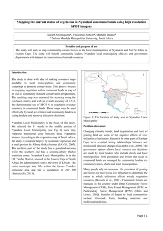
  • 1. Page | 1 Mapping the current status of vegetation in Nyandeni communal lands using high resolution SPOT imagery Adolph Nyamugama*, Vhusomuzi Sithole*, Mathabo Dadasi* * Nelson Mandela Metropolitan University, South Africa Benefits and purpose of use The study will seek to map communally-owned forests in the local municipalities of Nyandeni and Port St John's in Eastern Cape. The study will benefit community leaders, Nyandeni local municipality officials and government departments with interest in conservation of natural resources Introduction The study is done with idea of making resources maps available to local municipalities and community leadership to promote conservation. This project focuses on mapping vegetation within communal lands as way of an aid to community-initiated conservation programmes. The resulting map was measured for accuracy using the confusion matrix and with an overall accuracy of 0.733. We demonstrated use of SPOT 6 in vegetation resource inventory in communal lands. These maps may be used effectively by local government and community leaders in taking landuse and resource allocation decisions. Nyandeni Local Municipality is the focus of this study. We selected the 11 wards in the middle portion of Nyandeni Local Municipality (see Fig 1) since they represent transitional zone between three vegetation biomes. According to the vegetation map of South Africa, the study is occupied largely by savannah vegetation and a small portion by Albany thicket biomes (SANBI, 2007). The northern part of the study has a grassland-savanna while the southern end has a savanna-albany thicket transition zones. Nyandeni Local Municipality is in the OR Tambo District, situated in the Eastern Cape of South Africa. Its administrative seat is the town of Libode. The entire municipal area falls within the former Transkei homeland area and has a population of 290 390 (StatisticsSA, 2013).. Figure 1: The location of study area in Nyandeni Local Municipality Problem statement Changing climatic trends, land degradation and lack of grazing land are some of the negative effects of over utilization of resources. Research in other parts of Eastern Cape have revealed strong relationships between soil erosion and land use changes (Kakembo et al., 2009). The government system allows local resource use decisions are made by local leaders who include chiefs and local municipalities. Both grasslands and forests that occur in communal lands are managed by community leaders via community trusts, chiefs and local municipalities. Many people rely on savannas for provision of grazing and forests for fuel wood, it is important to determine the extent to which utilization affects woody vegetation resources (Wessels et al., 2011). Communal forests are managed in the country under either Community Forest Management (CFM), State Forest Management (SFM) or Participatory Forest Management (PFM) (Obiri and Lawes, 2002). Benefits of forests to local communities include; firewood, fruits, building materials and traditional medicines.
  • 2. Page | 2 Biome transition zones are also hypothesised to have higher species diversity compared to neighbouring biomes and their studies are valuable to climate change and biodiversity studies (Gosz, 1992). General causes of forest degradation and fragmentation are activities such as road construction, logging, conversion to agriculture or wildlife and related human and natural land uses (Wade et al., 2003). Biome transition zones therefore need to be monitored to mitigate overexploitation of these species. Overexploitation of available resources leads to negative effects to people living in these communal lands. The encroachment of woody plant species into the grasslands degrades rangelands quality (Munyati et al., 2011). The decline in forest resources do not only deprive humans of direct benefits but some bird species also decline (Trimble and van Aarde, 2011). Hence local leaders are often faced with the need to protect both grasslands and forests so as to avoid encroachment of shrub land and loss of forests. The extent of available resources is best presented in form of maps. In this study, we seek to map the current status of these forests in Nyandeni local municipalities. We will use SPOT imagery to produce high resolution maps showing the status of communally owned forests. Timeline Data collection May-Sept 2013 Call for proposals 12 August 2013 Proposal submission 23 September 2013 Notice of approval 24 October 2013 Delivery of Images 13 November 2013 Data analysis and write-up 13-20 Nov 2013 Presentation of results 21 November 2013 Technical and scientific approach & methods proposed In this study we managed to map vegetation within the study area using SPOT 6 imagery which was taken on the 26th of May 2013. We used the multispectral bands of SPOT 6, that is, Blue (0.45-0.52 µm), Green (0.53-0.59 µm), Red (0.625-0.695 µm), Near Infrared (0.76-0.89 µm). We used the vegetation delineation technique that is based on the Normalised Vegetation Index (NDVI) as a measure of vegetation vigour. We started with atmospheric correction (IAR Reflectance technique), then NDVI calculation, classification of NDVI image based on user defined threshold values (see table 2 in Appendix). We then performed accuracy assessment and visualisation. We used data collected for a related project, between May and July 2013, for accuracy assessment. Results We have managed to map the vegetation resources within the ten wards of Nyandeni Local Municipality. The map for vegetation resources is shown in Figure 1 below: Figure 2: The status of vegetation in ten wards of Nyandeni Local municipality. All in all the area is covered by grassland (48%) which used for grazing by local communities. The proportions of vegetation resources are shown in the graph below (Figure 2). Figure 3: Area covered by different vegetation classes in the Nyandeni study area According to the error matrix we managed to map the vegetation resources within the study area with an accuracy of 73.33% (see Table 1 in the Appendix section showing the Error Matrix). This indicates that our final map has mapped vegetation 73.33% correctly. Conclusion
  • 3. Page | 3 We have demonstrated that high spatial resolution SPOT 6 images can be successfully used to map and communicate the status of resources in communal areas. Indications are that terrain in the caused some misclassification of forests on south-facing slopes. Therefore in areas which are not steep, the method is capable of producing vegetation maps with higher accuracy. Multispectral remote sensing has been successfully used for mapping vegetation before but in this article we explored using high spatial resolution SPOT 6 imagery. The final map is a tool that may be used to support decision making in local communities. With a spatial resolution of 6m, SPOT 6 can be used for mapping and monitoring grasslands, shrub lands and forests in communal lands for use in resource allocation. Issues such as grazing land and building stand allocation can therefore be improved and monitored using SPOT 6 in communal lands. The dynamics of vegetation within biome transition zones can also be monitored using these image products. Reference GOSZ, J. R. 1992. Ecological Functions in a Biome Transition Zone: Translating Local Responses to Broad-Scale Dynamics. In: HANSEN, A. & CASTRI, F. (eds.) Landscape Boundaries. Springer New York. KAKEMBO, V., XANGA, W. W. & ROWNTREE, K. 2009. Topographic thresholds in gully development on the hillslopes of communal areas in Ngqushwa Local Municipality, Eastern Cape, South Africa. Geomorphology, 110. MUNYATI, C., SHAKER, P. & PHASHA, M. 2011. Using remotely sensed imagery to monitor savanna rangeland deterioration through woody plant proliferation: a case study from communal and biodiversity conservation rangeland sites in Mokopane, South Africa. Environmental monitoring and assessment, 176, 293-311. OBIRI, J. & LAWES, M. J. Challenges facing new forest policies in South Africa: Attitudes of forest users toward management of the coastal forests of the Eastern Cape. Natural Forests and Woodlands Symposium, 2002 Port Elizabeth. DWAF. SANBI. 2007. Biomes of South Africa, Lesotho and Swaziland. Available: http://bgis.sanbi.org/vegmap/biomes.asp. STATISTICSSA 2013. Nyandeni Local Municipality. In: AFRICA, S. S. (ed.). Pretoria. TRIMBLE, M. & VAN AARDE, R. 2011. Decline of birds in a human modified coastal dune forest landscape in South Africa. PloS one, 6. WADE, T., RIITTERS, K., WICKHAM, J. & JONES, K. 2003. Distribution and Causes of Global Forest Fragmentation. WESSELS, K. J., MATHIEU, R., ERASMUS, B. F. N., ASNER, G. P., SMIT, I. P. J., VAN AARDT, J. A. N., MAIN, R., FISHER, J., MARAIS, W., KENNEDY-BOWDOIN, T., KNAPP, D. E., EMERSON, R. & JACOBSON, J. 2011. Impact of communal land use and conservation on woody vegetation structure in the Lowveld savannas of South Africa. Forest Ecology and Management, 261, 19-29. Acknowledgement We would like to thank SANSA and ASTRIUM for providing the images for this study. Appendix Ground truth data no vegetation grassland shrub land forest Total classifie d map no vegetation 3 0 0 2 5 grassland 1 10 1 0 12 shrub land 1 1 7 1 10 forest 0 0 1 2 3 Total 5 11 9 5 30 Table 1: Accuracy assessment results. Classification NDVI range No vegetation -1 to 0 Grassland 0 to 0.25 Shrub land 0.25 to 0.5 Forest 0.5 to 1 Table 2: Classification threshold used