
Recommended
More Related Content
What's hot
What's hot (20)
Similar to Human-Wild Boar Conflict Study Banke National Park Nepal
Similar to Human-Wild Boar Conflict Study Banke National Park Nepal (20)
Recently uploaded
Recently uploaded (20)
Human-Wild Boar Conflict Study Banke National Park Nepal
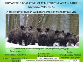
- 1. HUMAN-WILD BOAR CONFLICT AT BUFFER ZONE AREA IN BANKE NATIONAL PARK, NEPAL (A case study of Human-wild boar conflict at Mahadevpuri VDC) Supervisor: Dil Bahadur Purja Pun Chief Conservation officer (BaNP) Advisor: Prof. Basudev Pokhrel Assistant Dean (AFU) Researcher: Khim Prakash kc (Source:www.hubertushuntingtours.com/images/wild_boar_jpg) 2017 kpkc1633@gmail.com AGRICULTURE AND FORESTRY UNIVERSITY,HETUDA NEPAL
- 2. 2.Rationale of study 1.Introduction 3.Study Area 4.Objectives 5.Methodology 6.Result and Discussion 7.Conclusion 8.Acknowledgement Recommendation Outline Of Presentation and
- 3. Introduction Conflict: It takes place whenever incompatible activities occur. One party is Interfering,disturbing,obstructing, or in some other way making another party’s Actions less effective (Deutsch,1973). Human-wildlife conflict is defined as “any interaction between humans and wildlife that results in negative impacts on human social, economic or cultural life, on the conservation of wildlife population, or on the environment” (WWF 2005). Wild boar: Wild boar (Sus scrofa:Linnaeus,1758) also known as wild pig, wild swine or wild Hog, is a species of the pig genus Sus, part of the biological family Suidae found in the dense Jungle of Nepal. Wild boar are normally most active in the early morning and late afternoon. They can be found in a variety of habitats. They may inhabit grassy savanna areas, wooded forests, agricultural areas, shrublands and marshy swamp lands. They require a nearby water source and shelter (dense vegetation) to protect and conceal them from predation (Chapman and Trani, 2007). Wild boars are omnivorous, feeding on just about anything edible.
- 4. Rationale of study: The human wildlife conflict evaluation analysis gives the factual figure of entire conflict condition of any species population within the certain area or the location. This Reasearch mainly aims on achieving the information whether the pattern of the human-Wild boar conflict surrounding the Buffer zone area is cause of their habitat loss, land use pattern of human or cause of human enchroachment of Buffer zone area.
- 5. ® 0 40 80 120 16020 Kilometers Legend Mahadevpuri VDC Nahar Forest Agricultre Land Exposed Land Water body Sand Gravel/Khare khola Study Area MAP OF NEPAL BANKE DISTRICT MAHADEVPURI VDC
- 6. BaNP(Core Area): Establishments:2010 AD. Area:550 sq.km Buffer area: Establishments:2010 AD. Area:344 sq.km Districts: Banke(7 VDCs), Badiya(1 VDC), Dang(3 VDCs) and Salyan(3 VDCs) Coordinates: 81o39’29’’ to 82o12’19’’ east longitude and 27o58’13’’ to 28o21’26’’ north latitude. Eight ecosystem type: Sal forest, Deciduous Riverine forest, Savannahs and Grasslands, Mixed hardwood forest, Flood plain community, Bhabar and foot hills of Chure range. 90% natural forest is composed of mainly Sal, Karma, Khair and Sissoo species (Blon, 2014) The BaNP Buffer Zone falls in seven VDCs of Banke among which Mahadevpuri VDC (Recently Re-structured Rapti Sunari Gaupalika ward no.08 and 09 ) is the most incidental VDC (Gaupalika) in regarding of Human-wild boar Conflict. Mahadevpuri area is one of the major bottleneck area in TAL Nepal. Cont.> Study Area
- 7. Objectives: General objectives; The aim of the study is to explore the human-Wild boar conflict at buffer zone area (Mahadevpuri VDC) in Banke National Park, Nepal, and entrust solutions for an effective future conservation strategy. Specific objectives; To find out the current status of their natural habitat (water,space, food, cover) and develop the human wild boar conflict distribution cartography. To find out Wild boar damage levels and other associated impacts; To understand the perception and level of tolerance of people living in the vicinity of wild boar habitats.
- 8. Selection of study sites Data collection Data analysis Result and discussion Conclusion and Recommendation Primary data collection 1.Reconnaissance survey 2.Grop discussion 3.Direct observation 4.Use of diagram and picture 5.GPS data collection Secondary data collection Research reports, project documents,Journal article, literature,electronic media Book,Other publish and unpublish documents Research Flow Chart
- 9. Methodology 1.Questionnaire survey: A) Primary data collection Several structured self-administered questionnaire survey was used to collect data on human-wild boar conflict. Questions Types: i)close ended ii) open ended Altogether 74 households were included in the study using a simple random sampling method where it covered surrounding area of forest which cover about 500m of settlement area from nearby forest in which at least 10% households was selected randomly. 2.Group discussions: This discussion mainly focused on adult and older people. Discussions was made with randomly selected 6-10 respondent in each selected ward under the guidance of a supervisor.
- 10. 3.Direct observation: It was done in the affected area practically that enhanced for better analysis of present situation. It had help to judge the distance of farms from the buffer zone, crop damages, different techniques used in the farms to scare wild boar, changes in vegetation cover, the affected crops, nature of wild animals’ habitat fragmentation, and frequency of coming crop raiding wild boar to farm lands, estimating crop lost by crop raider, type and diversity of the top ranked damage caused by wild boars. 4.Use of diagrams and pictures; Diagrams and pictures or photo for Wild boar had used to identify animal species and its role in conflicts setting. This method had applied in those respondents who confuse about which wildlife damaged to their crops and it helped to collect details and clear information about wild boar where the problem of misunderstanding and language problem had to be solved. 5.GPS data collection GPS coordinates of the sites along with its aspect was collected and the location of conflict area was recorded to support in the conflict distribution analysis of Human-wild boar conflict. Cont.>
- 11. In this study, Landsat image (2017,January) of Banke National Park along with Buffer zone study area was collected from USGS Earth Explorer (earthexplorer.usgs.gov). Based on the objectives of study, Four types of features relevant to animals’ habitats had identified: presence of water, land cover, vegetation types (Mixed forest and Sal forest), and Space.The classifications for land cover and vegetation type had set up from a sample survey in the field. The land cover was typically divided into village areas, arable lands, forest and grasslands. The identified features had digitized into the GIS software ArcGIS 10.2, thus transformed into GIS layers easier to analyze. Simple Procedure of land use/land cover map with conflict distribution as follows: Cont.>> DATA ACQUISITION RECONNAISSANCE SURVEY DATA ENHANCEMENT, PROCESSING AND INTEGRATION LAND USE /LAND COVER CLASSIFICATION DEVELOPMENT OF A CLASSIFICATION CONTRIVE EDITING OF LAND USE/LAND COVER MAPS AND ENTERING OF FIELD COLLECTED GPS POINTS FINAL PRODUCTION OF LAND USE/LAND COVER MAPS WITH CONFLICT DISTRIBUTION OBJECTIVES OF LAND USE/LAND COVER
- 12. Software used for data analysis: (a) ArcGIS 10.2– This was used for the development of land use land cover classes and finally used to compliment the display and processing of the data. (b) Microsoft word – was used basically for the presentation of the research (c) Google Earth Pro:- Verification of classified image and sample data. (d) MS Excel :- Statistical analysis of results. B. Secondary data collection Secondary data for this research was mainly from archival sources such as office of Banke national park/ Buffer zone FUG office, various published and unpublished documents including project documents, thesis reports, literature, journal and electronic media.
- 13. Result and Discussion Natural habitat status Land Use/Land Cover (Habitat) Area of National Park (Core area +Buffer zone area) in (Sq.km) Percentage Sal Dominant Forest 184.89 20.68 Mixed Forest 549.97 61.54 Water body 5.56 0.62 Crop Land 45.62 5.10 Sand Gravel/Khare khola 35.09 3.92 Exposed Land 43.05 4.81 Irrigation Canal/Nahar 1.51 0.16 Grassland 16.28 1.83 Marsh Land/Pond 11.69 1.30 Total 893.66 100
- 14. DISTRIBUTION OF SAL AND MIXED FOREST Land cover class(Habitat ) Area (Core area +Buffer zone area)in sq.km Percentage Mixed forest 549.97 61.54 Sal Dominant forest 184.89 20.68 Others 158.8 17.78 Total 893.66 100 Cont.>
- 15. Land cover class(Habit at) Area (Core area +Buffer zone area)in sq.km Percentage Water body 17.15 1.91 Grassland 16.28 1.82 Others 860.23 96.26 Total 893.66 100 Cont.>>
- 16. Wild boar habitat analysis based on land use/land cover map and existing information: Four factors were identified as being the most important in determining the suitability of wild boar. Each factor was then subdivided into four levels of suitability. The table below represents the factors that were used to determine habitat suitability for wild boar. Vegetation type Proximity to water body Distance to Human Habitation Suitability Mixed forest Within 2km More than 5km 4 Grassland/Shrub land 2-3km 3-5km 3 Sal forest 3-3.5km 2-3km 2 Exposed land includes Sand Gravel More 3km Less than 2km 1 Suitability value Suitability code 1 Not suitable 2 Little suitable 3 Moderately suitable 4 Highly suitable Table : habitat suitability factor for wild boar Table : Suitability code for Habitat
- 17. Suitability code Area in sq.km Percentage Out of range 62.66 7.01 Not suitable 79.86 8.93 Little suitable 184.89 20.68 Moderately suitable 16.28 1.82 Highly suitable 549.97 61.54 Total 893.66 100 Cont.>>>>
- 19. Based on land use/land cover map of Banke National Park, above Habitat suitability class of Wild boar and conflict distribution cartography map following reason concluded why Human-Wild boar Conflict occurred in selected VDC or Gaupalika: 1. Land use/land cover Map denotes that because of limitations of water resources in core area of park, natural habitat in that area is not in good condition whereas around the buffer zone ,the area consists of little more water and marsh land in contrast to the national park core area, resulting to transformation of wild boar nearer to human society. 2. Wild boar prefer moist area with sufficient water resource so they are more concentrate towards water body area. 3. In summer season there is high chance of fire occurrence in forest leading to lack of food for wild boars, these conditions compels the wild boars to prefer their suitable food and water resources from cropland area where farmer make their cropland green almost every month of the year. From above reasons and causes we expect the conflicts to be greater in this area at those times. 4. Highly suitable habitat, moderately suitable habitat and little suitable habitat are distributed in near side of human settlements area or crop land area, this proves maximum number of wild boar may settle surrounding area of South part of buffer zone area which is close to crop land area. Due to such all combined habitat in those area wild boar can enter any time in agriculture land and consequently conflict arise with human.
- 20. Classification Accuracy Accuracy of Landsat image classification (2017, January) was assessed. As imposed in ArcGIS 10.2, the overall classification accuracy was found to be 86.16% the kappa coefficient (k) was found to be 0.8334. Thus the supervised classification was found to be satisfactory. Accuracy assessment table is given below.
- 21. Classifi ed data Sal fores t Mixe d forest Gras s land Wate r body Sand, Grave l Irrigatio n cannel Cro p land Mars h land Expose d land Total ( user ) Sal forest 20 1 1 0 0 0 0 1 2 25 Mixed Forest 0 47 1 0 0 0 0 3 1 51 Grasslan d 0 1 8 0 0 0 0 0 0 9 Water body 0 0 0 10 1 0 0 0 0 11 Sand, Gravel 0 0 0 0 10 0 0 0 1 11 Irrigation cannel 0 1 0 0 0 5 0 0 1 7 Crop land 0 0 0 0 2 0 14 0 0 16 Marsh land 0 2 0 1 1 0 0 12 0 16 Exposed land 0 0 0 0 1 0 1 0 11 13 Total ( produce r) 21 52 9 10 15 5 15 16 16 159 Table 6: image classification: Error matric
- 22. Class Names Reference totals Classified totals Number correct Producer Accuracy User Accuracy Sal forest 21 25 20 95.23% 80% Mixed forest 52 51 47 90.38% 92.15% Grassland 9 9 8 88.88% 88.88% Water body 10 11 10 100% 90.90% Sand, Gravel 15 11 10 66.67% 90.90% Irrigation cannel 5 7 5 100% 71.42% Crop land 15 16 14 93.33% 87.5% Marsh land 16 16 12 75% 75% Exposed land 16 13 11 68.75% 84.61% Table 7: image classification: Accuracy totals
- 23. Crop types Crop growing seasons More severe season(more conflict time) Results Maize (1)May/June- Aug./Sept.,(2)Jan./Feb- May/June April,May,June Because of insufficient food,water and shelter(extreme heat,forest fire etc.) in Natural forest,Feb/Mar/A pr/May were most conflict occurring seasons out of 12 month. Wheat Oct/Nov-Mar./Apr. February,March Potatoes (1)Sept./Oct.- Dec./Jan.,Dec./Jan.- Feb./Mar. February Rice June/July-Sept./Oct. Anytime between Growing season Dioscorea alata(Yam or Tarul),co-co Yam(pidaalu) Apr./May-Oct./Nov. April,May,June Mustard Sept./Oct.-Dec./Jan. February,March Lentil Oct/Nov-Mar./Apr. February,March Calendar of Seasonal crops occurring Month with seasonal crop being damaged by wild boar: Table : Calendar of Seasonal crops damaged condition by wild boar Cont.>>>>>>>
- 24. Crop types Average area damaged per year per HH (katha) Average damage per year per HH (kg) Economically Average annual damage per year per HH (NRs) Total damage per year (kg) Total damage in term of money(NRs) Maize (2 times per year) 3 244.5 5868 18093 434232 Wheat 1.5 148.7 4014.9 11003.8 297102.6 Rice or paddy 1 124 1984 9176 146816 Potato(2 times per year) 1 141.6 2241.6 10478.4 167654.4 Dioscorea alata(Yam or Tarul),co-co Yam(pidaalu) 0.12 29.65 889.5 2194.1 65823 Lentil 0.5 11 990 814 73260 mustard 0.25 08 640 592 47360 Pea 1 9.65 675.5 714.1 49987 Extent of wild boar destruction in term of area and money Cont.>>>>>>>>
- 25. Perception of people about arrival of wild boars to the cropland 0 10 20 30 40 50 60 70 80 Other Deforestationoftheforest Forestfire ImprovementofBZCM Encroachmentofforestarea foragricultureland Insearchofwater Insearchofpalatablefood Increaseinthenumberofwild boar HabitatDegradationinthe forest Totals Expanseofbarelandand Sand,Gravelintheforest 1.35 5.4 6.75 12.16 13.51 14.86 32.43 100 2,70 Sum of f by % Cont.>>>>>>>>>
- 26. Erection of used colored sarees This method is also a farmer’s innovation, which has a behavioral background as far as wild boar is concerned. By arranging used sarees of different colors around the crop will make wild boars to assume human presence in the area there by not preferring to enter into such areas. Even though, not feasible in all situations it has some marginal benefit in the areas of human movement. By using this, extent of damage by wild boar can be minimized to the level of 30-55%. Photo 1 : Fixing of used coloured sarees as border around the crop
- 27. DISCUSSION . For the whole year, it seems that conflict used to occur mostly due to availability of suitable habitat for feeding and sheltering, on the proximity of water sites for drinking, wallowing and cleaning. Farms seems as attractive factor for wild boars, possibly due presence of some types of crops ,such as small cereals, maize, barley, potatoes in addition nearby streams and other irrigation sources etc.that exist almost every month of the year. The management strategy suggested in this study can be useful for predicting the future presence of wild boars, assessing the quality of habitat for the species, and suggesting management actions which should aimed both at improving the carrying capacity and at avoiding damage to agriculture.
- 28. As a conclusion, the Banke national park including its buffer zone area both were found affected in equal like parameter. Destruction of Natural forest by local people, crop damage by wild boar, depredation of livestock, Decline of Natural habitat, poor relation with protection units etc. were the major factors that are impelling for the rising of human wild boar conflict and the most importantly crop destruction is very noticeable and unforgettable aspect where more than half of total crop production were found damaged. Though they have positive concept about wild boar conservation but damages, disturbances by wild boar and more than that the absence of wild boar damage compensation policies was leading majority of peoples to develop more aggressive attitude toward wild boar and their conservation. Conclusion
- 29. Recommendation: 1.Recent legislation system of Nepal is insufficient for coverage of compensation scheme of all wild animal so that it should be revised over time period. 2.To achieve sustainable mitigation of conflict ,fencing is the most appropriate way that should be regularly maintined. 3.Nation-wide species distribution and status surveys are needed for the wild boar where human-wild boar contact is needed to be prevented. 4.Habitat improvement-Water bodies has declined, So Further study is recommended. Extensive study on lower vegetation is recommended to ensure habitat of Wildlife.
- 30. Agricultural Activities: field of Maize crop Vegetable cultivation land Photo Plates:
- 31. co-co yam cultivation field Cultivation land of maize and vegetable together
- 32. Agriculture crops(Maize) damaged by wild boar
- 33. Destructed wheat crop land by wild boar Co-Co Yam(pidaalu) Damged by wild boar
- 34. Farmer’s Potatoes,Maize and Wheat crop land damaged by wild boar
- 35. Tradional Machan Guard prepaerd by Local people Traditional Bamboo fencing
- 37. Traditional rope bed in crop land for watching wild boar during Night time
- 38. Interaction with community people
- 39. Cont. > Using Diagram and photo for data collection with Local people
- 40. Cont. >
- 41. Pointing the areas destructed by wild boar ( photo on the left side)
- 42. Wild boar foot print found on Wheat land