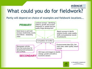
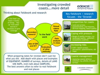
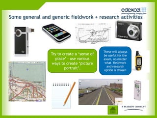
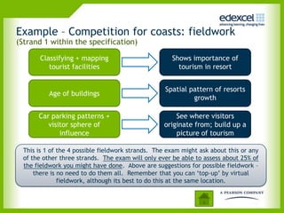
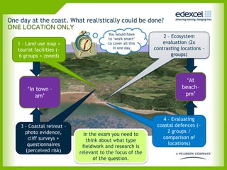
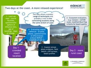
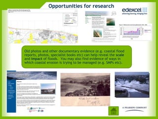
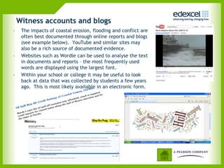
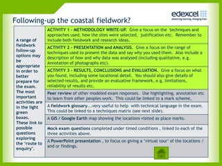
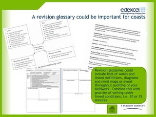
6GEO2 Unit 2 Geographical Investigations –
Student Guide: Crowded Coasts - Part 2
CONTENTS
                                                          In Part 1

            1.   Overview
            2.   Requirements of the specification
            3.   What are crowded coasts?
            4.   Investigating crowded coasts
            5.   Ideas for fieldwork
            6.   Research on crowded coasts
            7.   Making it work for the exam
Click on the information icon        to jump to that section.
Click on the home button        to return to this contents page
What could you do for fieldwork?
• Partly will depend on choice of examples and fieldwork locations….
Investigating crowded
                                 coasts….more detail
Thinking about fieldwork and research                  Key fieldwork + research
                                                        focuses – the ‘Strands’
   ‘In the field’ can
    mean a variety
    of things. ‘Top-                                       Competition for coasts
     up’ from other                                        • Land use surveys,
        sources if                                           questionnaires, oral histories,
   necessary to give                                         services mapping, beach quality.
        coverage
                                                           Coping with pressure
                                                           • Range of quality surveys, e.g.
                                                             landscape quality , pollution,
                                                             ecosystems condition.


                                                           Increasing risks
                                                           • Cliff + beach surveys,
                                                             perception, questionnaires, old
                                                             maps.

   When preparing notes for revision don’t just list       Coastal management
  what you did. Add depth with places and examples         • Assessing coastal defence
  of EQUIPMENT, NUMBER of surveys, details of LAND           schemes, e.g. photos, bi-polar
                                                             surveys.
        USE MAPS, even talk about SAMPLING.
   The best answers often to refer to real fieldwork
                   and real places
Some general and generic fieldwork + research activities


                                             These will always
                 Try to create a ‘sense of   be useful for the
                    place’ – use various     exam, no matter
                 ways to create ‘picture      what fieldwork
                                               and research
                         portrait’.           option is chosen
Example – Competition for coasts: fieldwork
(Strand 1 within the specification)

       Classifying + mapping                          Shows importance of
          tourist facilities                            tourism in resort


                                                    Spatial pattern of resorts
           Age of buildings
                                                             growth

       Car parking patterns +                          See where visitors
          visitor sphere of                        originate from; build up a
              influence                                picture of tourism

  This is 1 of the 4 possible fieldwork strands. The exam might ask about this or any
  of the other three strands. The exam will only ever be able to assess about 25% of
  the fieldwork you might have done. Above are suggestions for possible fieldwork –
      there is no need to do them all. Remember that you can ‘top-up’ by virtual
               fieldwork, although its best to do this at the same location.
One day at the coast. What realistically could be done?
ONE LOCATION ONLY
                                        You would have
                                        to ‘work smart’
                                                                2 – Ecosystem
   1 – Land use map +                   to cover all this       evaluation (2x
   tourist facilities (~                   in one day       contrasting locations –
    6 groups + zoned)                                               groups)


                                                                          ‘At
       ‘In town –                                                       beach–
          am’                                                            pm’


                                                               4 – Evaluating
    3 – Coastal retreat –                                    coastal defences (~
      photo evidence,                                            2 groups /
                              In the exam you need to
        cliff surveys +                                        comparison of
                               think about what type
       questionnaires                                            locations)
                             fieldwork and research is
      (perceived risk)      relevant to the focus of the
                                   of the question.
Two days at the coast. A more relaxed experience!

                         Two days allows a greater
  1 – Land use            range of techniques and
 map + tourist             probably a visit to two          2 – Ecosystem evaluation,
   facilities,          contrasting locations along           e.g. transect + ACFOR
 questionnaire           the same stretch of coast          scale, modified Blue Flag
   (sphere of                                               criteria for beach quality
influence etc),
     age of         4 – Evaluating coastal
buildings. Maps      defences – bi-polar,
   of change.       photos, questionnaires
                       of effectiveness
                      (COULD REPEAT +
                     COMPARE AT DAY 2)


          Day 1 –                   3 – Coastal retreat –
                                   photo evidence, field
         crowded                   sketch, cliff surveys,       Day 2 – more
          resort                       beach profiles            rural coast
         location
Opportunities for research


Old photos and other documentary evidence (e.g. coastal flood
reports, photos, specialist books etc) can help reveal the scale
and impact of floods. You may also find evidence of ways in
which coastal erosion is trying to be managed (e.g. SMPs etc).
Witness accounts and blogs
•    The impacts of coastal erosion, flooding and conflict are
     often best documented through online reports and blogs
     (see example below). YouTube and similar sites may
     also be a rich source of documented evidence.
•    Websites such as Wordle can be used to analyse the text
     in documents and reports – the most frequently used
     words are displayed using the largest font.
•    Within your school or college it may be useful to look
     back at data that was collected by students a few years
     ago. This is most likely available in an electronic form.
Following-up the coastal fieldwork?
                  ACTIVITY 1 – METHODOLOGY WRITE-UP. Give a focus on the techniques and
                  approaches used, how the sites were selected, justification etc. Remember to
 A range of       include both fieldwork and research ideas.
 fieldwork
                  ACTIVITY 2 – PRESENTATION and ANALYSIS. Give a focus on the range of
 follow-up
                  techniques used to present the data and say why you used them. Also include a
 options may
                  description of how and why data was analysed (including qualitative, e.g.
 be
                  Annotation of photographs etc).
 appropriate
 in order to      ACTIVITY 3 – RESULTS, CONCLUSIONS and EVALUATION. Give a focus on what
 better           you found, including some locational detail. You should also give details of
 prepare for      selected results, and provide an evaluative framework, e.g. limitations,
 the exam.        reliability of results etc.
 The most         Peer review of other modeled exam responses. Use highlighting, annotation etc
 important        to learn from other peoples work. This could be linked to a mark scheme,
 activities are
 in the light     A fieldwork glossary...very useful to help with technical language in the exam.
 green            This could be linked to a techniques matrix (see next slide).
 boxes.           A GIS / Google Earth map showing the locations visited as place marks.
 These link to
 possible         Mock exam questions completed under timed conditions , linked to each of the
 questions        three activities above.
 exploring
                  A PowerPoint presentation , to focus on giving a ‘virtual tour’ of the locations /
 the ‘route to
                  and or findings.
 enquiry’.
A revision glossary could be important for coasts


                           Revision glossaries could
                           include lists of words and
                           linked definitions, diagrams
                           and mind maps or event
                           throughout auditing of your
                           fieldwork. Combine this with
                           practise of writing under
                           timed conditions, i.e. 10 or 15
                           minutes
Summary

• Revise your personal fieldwork and research
  on coasts thoroughly.
• When relevant, know details on sampling,
  surveys, presentation, analysis and
  conclusions.
• Know the location(s) and why it was chosen
  for a coastal study.
• What were the site details and what about the
  use of any use any specialist equipment?
• Be clear about the different ways to manage
  coasts and if they worked (locational details).
• The exam will only ever be able to test 25% of
  the fieldwork you may have done....so its not
  a case of write all you know or all you did on
  the fieldwork day. BE SELECTIVE.
Now see part 1 for the Introduction to Crowded
                    Coasts

Coasts part2

  • 1.
    6GEO2 Unit 2Geographical Investigations – Student Guide: Crowded Coasts - Part 2
  • 2.
    CONTENTS In Part 1 1. Overview 2. Requirements of the specification 3. What are crowded coasts? 4. Investigating crowded coasts 5. Ideas for fieldwork 6. Research on crowded coasts 7. Making it work for the exam Click on the information icon to jump to that section. Click on the home button to return to this contents page
  • 3.
    What could youdo for fieldwork? • Partly will depend on choice of examples and fieldwork locations….
  • 4.
    Investigating crowded coasts….more detail Thinking about fieldwork and research Key fieldwork + research focuses – the ‘Strands’ ‘In the field’ can mean a variety of things. ‘Top- Competition for coasts up’ from other • Land use surveys, sources if questionnaires, oral histories, necessary to give services mapping, beach quality. coverage Coping with pressure • Range of quality surveys, e.g. landscape quality , pollution, ecosystems condition. Increasing risks • Cliff + beach surveys, perception, questionnaires, old maps. When preparing notes for revision don’t just list Coastal management what you did. Add depth with places and examples • Assessing coastal defence of EQUIPMENT, NUMBER of surveys, details of LAND schemes, e.g. photos, bi-polar surveys. USE MAPS, even talk about SAMPLING. The best answers often to refer to real fieldwork and real places
  • 5.
    Some general andgeneric fieldwork + research activities These will always Try to create a ‘sense of be useful for the place’ – use various exam, no matter ways to create ‘picture what fieldwork and research portrait’. option is chosen
  • 6.
    Example – Competitionfor coasts: fieldwork (Strand 1 within the specification) Classifying + mapping Shows importance of tourist facilities tourism in resort Spatial pattern of resorts Age of buildings growth Car parking patterns + See where visitors visitor sphere of originate from; build up a influence picture of tourism This is 1 of the 4 possible fieldwork strands. The exam might ask about this or any of the other three strands. The exam will only ever be able to assess about 25% of the fieldwork you might have done. Above are suggestions for possible fieldwork – there is no need to do them all. Remember that you can ‘top-up’ by virtual fieldwork, although its best to do this at the same location.
  • 7.
    One day atthe coast. What realistically could be done? ONE LOCATION ONLY You would have to ‘work smart’ 2 – Ecosystem 1 – Land use map + to cover all this evaluation (2x tourist facilities (~ in one day contrasting locations – 6 groups + zoned) groups) ‘At ‘In town – beach– am’ pm’ 4 – Evaluating 3 – Coastal retreat – coastal defences (~ photo evidence, 2 groups / In the exam you need to cliff surveys + comparison of think about what type questionnaires locations) fieldwork and research is (perceived risk) relevant to the focus of the of the question.
  • 8.
    Two days atthe coast. A more relaxed experience! Two days allows a greater 1 – Land use range of techniques and map + tourist probably a visit to two 2 – Ecosystem evaluation, facilities, contrasting locations along e.g. transect + ACFOR questionnaire the same stretch of coast scale, modified Blue Flag (sphere of criteria for beach quality influence etc), age of 4 – Evaluating coastal buildings. Maps defences – bi-polar, of change. photos, questionnaires of effectiveness (COULD REPEAT + COMPARE AT DAY 2) Day 1 – 3 – Coastal retreat – photo evidence, field crowded sketch, cliff surveys, Day 2 – more resort beach profiles rural coast location
  • 9.
    Opportunities for research Oldphotos and other documentary evidence (e.g. coastal flood reports, photos, specialist books etc) can help reveal the scale and impact of floods. You may also find evidence of ways in which coastal erosion is trying to be managed (e.g. SMPs etc).
  • 10.
    Witness accounts andblogs • The impacts of coastal erosion, flooding and conflict are often best documented through online reports and blogs (see example below). YouTube and similar sites may also be a rich source of documented evidence. • Websites such as Wordle can be used to analyse the text in documents and reports – the most frequently used words are displayed using the largest font. • Within your school or college it may be useful to look back at data that was collected by students a few years ago. This is most likely available in an electronic form.
  • 11.
    Following-up the coastalfieldwork? ACTIVITY 1 – METHODOLOGY WRITE-UP. Give a focus on the techniques and approaches used, how the sites were selected, justification etc. Remember to A range of include both fieldwork and research ideas. fieldwork ACTIVITY 2 – PRESENTATION and ANALYSIS. Give a focus on the range of follow-up techniques used to present the data and say why you used them. Also include a options may description of how and why data was analysed (including qualitative, e.g. be Annotation of photographs etc). appropriate in order to ACTIVITY 3 – RESULTS, CONCLUSIONS and EVALUATION. Give a focus on what better you found, including some locational detail. You should also give details of prepare for selected results, and provide an evaluative framework, e.g. limitations, the exam. reliability of results etc. The most Peer review of other modeled exam responses. Use highlighting, annotation etc important to learn from other peoples work. This could be linked to a mark scheme, activities are in the light A fieldwork glossary...very useful to help with technical language in the exam. green This could be linked to a techniques matrix (see next slide). boxes. A GIS / Google Earth map showing the locations visited as place marks. These link to possible Mock exam questions completed under timed conditions , linked to each of the questions three activities above. exploring A PowerPoint presentation , to focus on giving a ‘virtual tour’ of the locations / the ‘route to and or findings. enquiry’.
  • 12.
    A revision glossarycould be important for coasts Revision glossaries could include lists of words and linked definitions, diagrams and mind maps or event throughout auditing of your fieldwork. Combine this with practise of writing under timed conditions, i.e. 10 or 15 minutes
  • 13.
    Summary • Revise yourpersonal fieldwork and research on coasts thoroughly. • When relevant, know details on sampling, surveys, presentation, analysis and conclusions. • Know the location(s) and why it was chosen for a coastal study. • What were the site details and what about the use of any use any specialist equipment? • Be clear about the different ways to manage coasts and if they worked (locational details). • The exam will only ever be able to test 25% of the fieldwork you may have done....so its not a case of write all you know or all you did on the fieldwork day. BE SELECTIVE.
  • 14.
    Now see part1 for the Introduction to Crowded Coasts