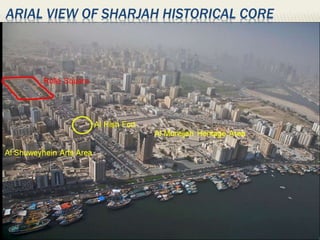
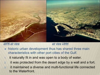
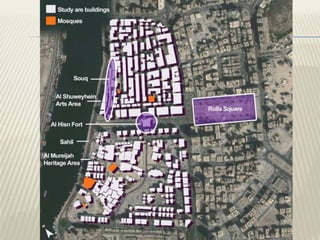
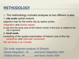
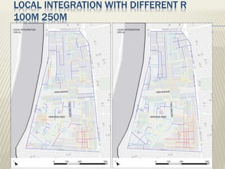
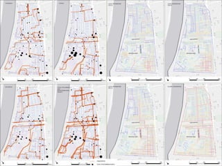
This document analyzes the spatial structure and issues facing the historic city center of Sharjah, UAE using space syntax methodology. It finds that the historic center was originally highly integrated and connected to the waterfront, but modern development has pulled the city inland and segregated the historic core. This has led to problems like traffic, environmental degradation, and the center becoming unattractive. The analysis identifies solutions like reconnecting the historic core to the waterfront and promoting active land uses to revitalize the area and preserve the cultural heritage.
LE COBUSIER, BACKGROUNG OF CITY DEVELOPMENT IN EARLY 20th CENTURY, THE GRID CONCEPT, Contemporary City, Radiant City, THE RADIANT CITY CONCEPT, CONCEPT OF RADIANT CITY, HOUSING TOWERS
Urban conservation techniques and strategies mainly followed in the INDIA.This is done for my friends in B.ARCH(VIIth semester) JNAFAU & JNTUK.
University.
CAMILLO SITTE
He was an Austrian architect, born Vienna in 1843
Camillo Sitte was the son of the architect Franz Sitte(1808–79) and the father of the architect Siegfried Sitte (1876–1945).
He was an art historian and architect whose writings, according to Eliel Saarinen, were familiar to German-speaking architects of the late 19th century.
He was also an painter and urban theorist whose work influenced urban planning and land use regulation.
Sitte traveled extensively in Western Europe, seeking to identify the factors that made certain towns feel warm and welcoming.
Sitte saw architecture was a process and product of culture.
BOOKS BY SITTE-
1. City Planning According to Artistic Principles, 1889
2. The Birth of Modern City Planning. Dover Publications, 2006.
It is an assignment on urban design basic factors, whereas a designer should keep in mind in urban designing.
Here I tried to describe factors by pointing as anyone could find a basic concept o urban design. Hope it'll be helpful.
Architectural Space as a Network - Physical and Virtual CommunitiesUCL
Presentation at Workshop 'Innovation at the Verge - Computational Models of Physical / Virtual Space Interaction'; Leiden/NL, 18 Dec 2012
This talk explores the role of architectural space as a network that structures patterns of co-presence of occupants. It is suggested that one outcome of the configuration of space (in buildings or cities) is to structure a field of potential co-presence between people – a ‘virtual community’ - which gives rise to real encounter networks as people move through and inhabit it. Through the structure of physical space and the associated field of potential co-presence social groupings are either conserved, or new groupings are generated. Examples are given to illustrate this.
It is furthermore suggested that society coheres by means of both spatial and transpatial solidarities, which means individuals will participate in multiple distinct networks at the same time. Spatial networks are generated through face-to-face encounter in architectural space, and are dependent on spatial relational structures, while transpatial ties result from shared values, ethos and identities.
As technologies become more and more ubiquitous, they increasingly structure people’s patterns of interaction and seemingly move them away from physical space and into a new realm of online communities. This raises the question of whether physical space still plays the role it used to play and how we can conceptualise multiple overlapping network affiliations in both physical and virtual spaces. Therefore the affordances of technology in offering means of communication and encounter across time and space are discussed and put into perspective of the real life face-to-face networks of people realised in physical space.
Space Syntax as a theory and method to unpack spatial networks and social processes
Centre for Advanced Spatial Analysis (CASA) Research Seminar, UCL, 3 Feb 2016
DONE IN 2014 Al Damtha city Jordan population growth. QUANTITATIVE ASSESSMENT OF LAND USE . Comparison of per capita share (m²/person) with other local and international standards
Shops front sign boards & adds billboards location jordan irbid the uni...Shomou' Aljizawi
IRBID JORDAN,Visual pollution is an aesthetic issue referring to the impacts of pollution that impair one's ability to enjoy a view
Dr. Nasser Abu Anzeh
Done by:
Noor Qteshat
Shomou al Jizawi
regression model. Use regression model to estimate the growth in Irbid and the main elements that effect
the growth and the built up area.
Estimate the growth direction in Irbid by using GIS system
Done by Shomou Farouq Al Jizawi
Supervision D.r Imad al hashimy
Presentation in the ISOCARP Congress in October 2015. We spoke about the guides of good practice for the coexistence between cities and ports. Particularly how the strategies the propose have been used in the cases of Genoa and Hamburg
The Study of Safavi Northern Chahar-Bagh Street of Shiraz, Iran; from the Sta...Dorna Eshrati
The historical urban landscape is a new approach towards the historical city as the product
of human interaction with micro ecosystem over the passage of time that has recently gained a special
position in urban conservation. This paper begins with raising the question that how this approach can
be used to solve the challenges of conservation and development of historical cities. Exploring the
conservation documents indicate that viewpoint to historical city has shifted from ‘the atomistic perspective
to holistic’, ‘static to dynamic’, ‘product-oriented to process-oriented’, ‘conflict with micro-ecosystem
to interact with micro-ecosystem’, and ‘the contrast of conservation and development’ to the integration
of them. The purpose of this paper is to review the northern Safavi Chahar-Bagh street of shiraz in the
city master plan to find out how the street conservation and development is based on historical urban
landscape. The data for this research were collected through observations and documents review and
were analyzed qualitatively. The survey results show that the new doctrines of urban conservation seek
to integrate conservation and development based on historical urban landscape; however, the definition
of the Historical city boundary in the master plan of shiraz is still based on static and atomistic doctrines
that consider historical cities limited to the historical wall. This is while the northern Chahar-Bagh street
of shiraz which was the main historical axis of the city during the Safavi period was located outside the
historical wall of the city. Not paying attention to this street has caused the gradual destruction of this
historical urban landscape, despite the individual protection of some of its elements. Reviewing the case
study based on the historical urban landscape approach reveals the need for a reconsideration and revision
of the developments urban plans.
An entry to the 14th International Planning History Society Conference 2010, “Urban Transformation: Controversies, Contrasts and Challenges”, Istanbul/Turkey.
Bab Al-Bahrain Avenue is one of the liveliest streets and its location is in the intermediate of the historical part that gave the avenue a strong historical dimension in the urban context of Manama city, Kingdom of Bahrain. Moreover, the avenue has economic and cultural significance activities. The socio-economic value of Bab-AL Bahrain and the gold market make them the busiest streets in Manama. The existing users of the avenue are variable between residences, local visitors and tourist. Unfortunately, with the rapid urban developing for the Manama City in general and Bab Al Bahrain area, and the changing for the economic base for most of the original families they moved to other suitable places to them while new non-Bahraini replaced them. As a result, the sense of identity and belonging is not considerable. Consequently, the identity for these areas is in its way to disappear. This research analyzed the street furniture condition and focused on the act of street furniture role in revitalizing Bahraini identity in such an area. Moreover, the research draws the point of revitalizing the sense of belonging for the residences, which will influence positively upon the open spaces’ conditions and the visual quality.
Al zarqa river pollution causes, actions and revival ………rectangular of pollutionShomou' Aljizawi
Environment Impact Assessment for Al Zarqa River in Jordan, Rectangular Of Pollution , done by Eng Shomou + Eng Noor and supervised by Dr. Nasser Abu Anzeeh
Overview of the fundamental roles in Hydropower generation and the components involved in wider Electrical Engineering.
This paper presents the design and construction of hydroelectric dams from the hydrologist’s survey of the valley before construction, all aspects and involved disciplines, fluid dynamics, structural engineering, generation and mains frequency regulation to the very transmission of power through the network in the United Kingdom.
Author: Robbie Edward Sayers
Collaborators and co editors: Charlie Sims and Connor Healey.
(C) 2024 Robbie E. Sayers
CFD Simulation of By-pass Flow in a HRSG module by R&R Consult.pptxR&R Consult
CFD analysis is incredibly effective at solving mysteries and improving the performance of complex systems!
Here's a great example: At a large natural gas-fired power plant, where they use waste heat to generate steam and energy, they were puzzled that their boiler wasn't producing as much steam as expected.
R&R and Tetra Engineering Group Inc. were asked to solve the issue with reduced steam production.
An inspection had shown that a significant amount of hot flue gas was bypassing the boiler tubes, where the heat was supposed to be transferred.
R&R Consult conducted a CFD analysis, which revealed that 6.3% of the flue gas was bypassing the boiler tubes without transferring heat. The analysis also showed that the flue gas was instead being directed along the sides of the boiler and between the modules that were supposed to capture the heat. This was the cause of the reduced performance.
Based on our results, Tetra Engineering installed covering plates to reduce the bypass flow. This improved the boiler's performance and increased electricity production.
It is always satisfying when we can help solve complex challenges like this. Do your systems also need a check-up or optimization? Give us a call!
Work done in cooperation with James Malloy and David Moelling from Tetra Engineering.
More examples of our work https://www.r-r-consult.dk/en/cases-en/
Final project report on grocery store management system..pdfKamal Acharya
In today’s fast-changing business environment, it’s extremely important to be able to respond to client needs in the most effective and timely manner. If your customers wish to see your business online and have instant access to your products or services.
Online Grocery Store is an e-commerce website, which retails various grocery products. This project allows viewing various products available enables registered users to purchase desired products instantly using Paytm, UPI payment processor (Instant Pay) and also can place order by using Cash on Delivery (Pay Later) option. This project provides an easy access to Administrators and Managers to view orders placed using Pay Later and Instant Pay options.
In order to develop an e-commerce website, a number of Technologies must be studied and understood. These include multi-tiered architecture, server and client-side scripting techniques, implementation technologies, programming language (such as PHP, HTML, CSS, JavaScript) and MySQL relational databases. This is a project with the objective to develop a basic website where a consumer is provided with a shopping cart website and also to know about the technologies used to develop such a website.
This document will discuss each of the underlying technologies to create and implement an e- commerce website.
Cosmetic shop management system project report.pdfKamal Acharya
Buying new cosmetic products is difficult. It can even be scary for those who have sensitive skin and are prone to skin trouble. The information needed to alleviate this problem is on the back of each product, but it's thought to interpret those ingredient lists unless you have a background in chemistry.
Instead of buying and hoping for the best, we can use data science to help us predict which products may be good fits for us. It includes various function programs to do the above mentioned tasks.
Data file handling has been effectively used in the program.
The automated cosmetic shop management system should deal with the automation of general workflow and administration process of the shop. The main processes of the system focus on customer's request where the system is able to search the most appropriate products and deliver it to the customers. It should help the employees to quickly identify the list of cosmetic product that have reached the minimum quantity and also keep a track of expired date for each cosmetic product. It should help the employees to find the rack number in which the product is placed.It is also Faster and more efficient way.
Hybrid optimization of pumped hydro system and solar- Engr. Abdul-Azeez.pdffxintegritypublishin
Advancements in technology unveil a myriad of electrical and electronic breakthroughs geared towards efficiently harnessing limited resources to meet human energy demands. The optimization of hybrid solar PV panels and pumped hydro energy supply systems plays a pivotal role in utilizing natural resources effectively. This initiative not only benefits humanity but also fosters environmental sustainability. The study investigated the design optimization of these hybrid systems, focusing on understanding solar radiation patterns, identifying geographical influences on solar radiation, formulating a mathematical model for system optimization, and determining the optimal configuration of PV panels and pumped hydro storage. Through a comparative analysis approach and eight weeks of data collection, the study addressed key research questions related to solar radiation patterns and optimal system design. The findings highlighted regions with heightened solar radiation levels, showcasing substantial potential for power generation and emphasizing the system's efficiency. Optimizing system design significantly boosted power generation, promoted renewable energy utilization, and enhanced energy storage capacity. The study underscored the benefits of optimizing hybrid solar PV panels and pumped hydro energy supply systems for sustainable energy usage. Optimizing the design of solar PV panels and pumped hydro energy supply systems as examined across diverse climatic conditions in a developing country, not only enhances power generation but also improves the integration of renewable energy sources and boosts energy storage capacities, particularly beneficial for less economically prosperous regions. Additionally, the study provides valuable insights for advancing energy research in economically viable areas. Recommendations included conducting site-specific assessments, utilizing advanced modeling tools, implementing regular maintenance protocols, and enhancing communication among system components.
About
Indigenized remote control interface card suitable for MAFI system CCR equipment. Compatible for IDM8000 CCR. Backplane mounted serial and TCP/Ethernet communication module for CCR remote access. IDM 8000 CCR remote control on serial and TCP protocol.
• Remote control: Parallel or serial interface.
• Compatible with MAFI CCR system.
• Compatible with IDM8000 CCR.
• Compatible with Backplane mount serial communication.
• Compatible with commercial and Defence aviation CCR system.
• Remote control system for accessing CCR and allied system over serial or TCP.
• Indigenized local Support/presence in India.
• Easy in configuration using DIP switches.
Technical Specifications
Indigenized remote control interface card suitable for MAFI system CCR equipment. Compatible for IDM8000 CCR. Backplane mounted serial and TCP/Ethernet communication module for CCR remote access. IDM 8000 CCR remote control on serial and TCP protocol.
Key Features
Indigenized remote control interface card suitable for MAFI system CCR equipment. Compatible for IDM8000 CCR. Backplane mounted serial and TCP/Ethernet communication module for CCR remote access. IDM 8000 CCR remote control on serial and TCP protocol.
• Remote control: Parallel or serial interface
• Compatible with MAFI CCR system
• Copatiable with IDM8000 CCR
• Compatible with Backplane mount serial communication.
• Compatible with commercial and Defence aviation CCR system.
• Remote control system for accessing CCR and allied system over serial or TCP.
• Indigenized local Support/presence in India.
Application
• Remote control: Parallel or serial interface.
• Compatible with MAFI CCR system.
• Compatible with IDM8000 CCR.
• Compatible with Backplane mount serial communication.
• Compatible with commercial and Defence aviation CCR system.
• Remote control system for accessing CCR and allied system over serial or TCP.
• Indigenized local Support/presence in India.
• Easy in configuration using DIP switches.
Immunizing Image Classifiers Against Localized Adversary Attacksgerogepatton
This paper addresses the vulnerability of deep learning models, particularly convolutional neural networks
(CNN)s, to adversarial attacks and presents a proactive training technique designed to counter them. We
introduce a novel volumization algorithm, which transforms 2D images into 3D volumetric representations.
When combined with 3D convolution and deep curriculum learning optimization (CLO), itsignificantly improves
the immunity of models against localized universal attacks by up to 40%. We evaluate our proposed approach
using contemporary CNN architectures and the modified Canadian Institute for Advanced Research (CIFAR-10
and CIFAR-100) and ImageNet Large Scale Visual Recognition Challenge (ILSVRC12) datasets, showcasing
accuracy improvements over previous techniques. The results indicate that the combination of the volumetric
input and curriculum learning holds significant promise for mitigating adversarial attacks without necessitating
adversary training.
Saudi Arabia stands as a titan in the global energy landscape, renowned for its abundant oil and gas resources. It's the largest exporter of petroleum and holds some of the world's most significant reserves. Let's delve into the top 10 oil and gas projects shaping Saudi Arabia's energy future in 2024.
2. UNESCO selected the Emirate of Sharjah as the cultural capital
of the Arab World.
Sharjah’s historic center
PROBLEMS
traffic congestion
environmental degradation
unattractive for visitors and inhabitants.
TO
reverse any further degradation of the historic city center
achieve economic and social gains
conserve the environment
preserve the cultural heritage.
THE CHALLENGE
revitalizing historic Sharjah by
Identifying ….understanding ….providing
solutions to problems that have emerged through its recent rapid
growth.
The main goal is
Put future development strategy
urban design guidelines for revitalizing the historic core.
3. Space Syntax is used
AS a diagnostic tool
TO understand how the history and evolution
of the city’s structure after modernization
had led to patterns of
density
land use
socio-economic settlement.
5. historic urban development thus has shared three main
characteristics with other port cities of the Gulf.
1. it naturally fit in and was open to a body of water.
2. it was protected from the desert edge by a wall and a fort.
3. it maintained a diverse and multi-functional life connected
to the Waterfront.
1976 air view air view 1994
6.
7.
8. METHODOLOGY
The methodology included analyses at two different scales
1- city scale spatial analysis
segment map for the entire city by space syntax.
integration and choice values
to see how the study area of the historic center of the town is related to the
city in general
2- local scale.
consisting of the spatial examination of historic core of the city
pedestrian and vehicular movement.
We will study it on 2 levels
City scale segment analysis of Sharjah:
Global integration, rN…… and local integration r500
Global choice, rN ………..and local choice r500
9. CITY SCALE SEGMENT ANALYSIS OF SHARJAH:
GLOBAL INTEGRATION, RN…… AND LOCAL INTEGRATION R500
GLOBAL CHOICE, RN ………..AND LOCAL CHOICE R500
10. ANALYSIS AT THE CITY SCALE
Spatial analysis of the city of Sharjah
Global integration rN local integration, r500
Global choice rN local choice r500
11. ANALYSIS AT THE CITY SCALE
INTEGRATION
the roads running parallel to the waterfront and connecting
Sharjah with Dubai.
the most integrated streets forming a grid pattern
Global integration rN
edge effect
High integrated near the
borders of the map and the
edges of the city.
Because segregated nature
of the center streets in the
gridal pattern where the
residential neighborhoods
Created integrated edges
12. interesting
inside of each integrated gridal road system,
the center where the residential neighborhoods
are located, is segregated
residential neighborhood HIGH privacy low
integration
High integration
low integration
ANALYSIS AT THE CITY SCALE
INTEGRATION
13. Industrial zone more integrated
High integration
Medium integration
ANALYSIS AT THE CITY SCALE
INTEGRATION
18. ANALYSIS AT THE CITY SCALE
CHOICE Global choice rN
less sensitive to edge effect
The streets that create the gridal system is
much more clearly differentiated then the
ones within the grid
The analysis local choice is similar to the
local integration analysis in that the local
centers are also highlighted in this map. One
more major difference is the higher
integration value of the historical core and its
surroundings
suggesting the potential of this area.
The modern developments towards the
inlands almost totally lack any local centers,
which demonstrates how the modern
developments do not follow a similar pattern
19. ANALYSIS AT THE HISTORICAL CENTER
SPATIAL ANALYSIS OF THE STUDY AREA
A ‘spatial modeling’ study has been used to
assess the accessibility of linkages through
the study area. Space syntax method has
been used to analyze the spatial
configuration of Sharjah Historic area. A
segment map has been constructed showing
all the accessible space in the study area.
The segment map has been processed using
the DepthmapX v.28 software and integration
and choice values for each line on the map
20. When segment maps are analyzed for choice
value at the global level, the streets
surrounding the heritage area as well as the
Hisn Avenue show similar characteristics as
the heritage area is less integrated. At the
local level (r100), the choice value for
Sharjah heritage area located within the
reconstructed historic wall is higher then the
rest of the historic area.
ANALYSIS AT THE HISTORICAL CENTER
SPATIAL ANALYSIS OF THE STUDY AREA
25. ANALYSIS AT THE LOCAL SCALE
PEDESTRIAN AND VEHICULAR MOVEMENT ANALYSIS
observed pedestrian and vehicular
movement
Pedestrian followings and pedestrian density on
Thursday, Friday, Saturday and all days together.
pedestrians’ route choice behavior and the
most commonly used routes
26.
27. ANALYSIS OF THE RELATION BETWEEN MOVEMENT
PATTERNS AND SPATIAL CONFIGURATION
The relation is clear between the space syntax
analysis and the vehicle
The relation is very low between the space syntax
analysis and the pedestrian movement
fact that there is quite a lot of pedestrian movement in
the area
Its related to the activities that the area houses such as
the old mosques
the major banks
Old market
Moreover, the dominance of male movement indicate
that
land use characteristics
religion related uses
28. ANALYSIS
The port is a centre of international commerce
in the region.
Historically developed along the waterfront up
until 1970s
modern planning that pulled the urban growth
toward the inland.
The University town and the residential
neighborhoods around the ancient site are the
first modern developments.
These developments inevitably
changed the social and spatial structure of historic
29. there is a vehicular road between the sea and
these shopping units.
The materials were unloaded from the ships
directly to the depot area of the shops.
Solution
restore the link between the souk and
waterfront,
recreate and strengthen a continuance of
waterfront to the heritage area
turn lead to an increase in the vitality of the
center
create an economically productive historic core.
30. since they are one big
continuous piece
they cut the breeze coming
from the sea to cool of the
streets and make the space
attractive for pedestrians.
31. future design proposal
the area should have land uses that promote active
uses such as
services
accommodation
Entertainment
that would also help protect the vitality of the
heritage area
the wall separates the space defined by the wall from
the rest of the heritage area and in turn adds to the
segregation of the historic core from the rest of the
city
32. very similar to the cases of other Islamic cities such as Jeddah….
the city developed based on modern urban planning principles
focusing on the primacy of vehicular traffic the scale of the
context increased.
The historic fabric of these cities has changed as a result of
major program of road building
physical reshaping
which shifted the structure of the integration core
weakened the connection of the historic centers.
So the historic core has a structure itself but as the city gets
developed this structure gets disconnected from the city and the
complex of local centers and sub-centers fade away.
Thus we can conclude that, as stated in earlier studies, the
problems faced in historic city centers are not local but global and
the task is
NOT TO REDESIGN BUT TO
RECONNECT