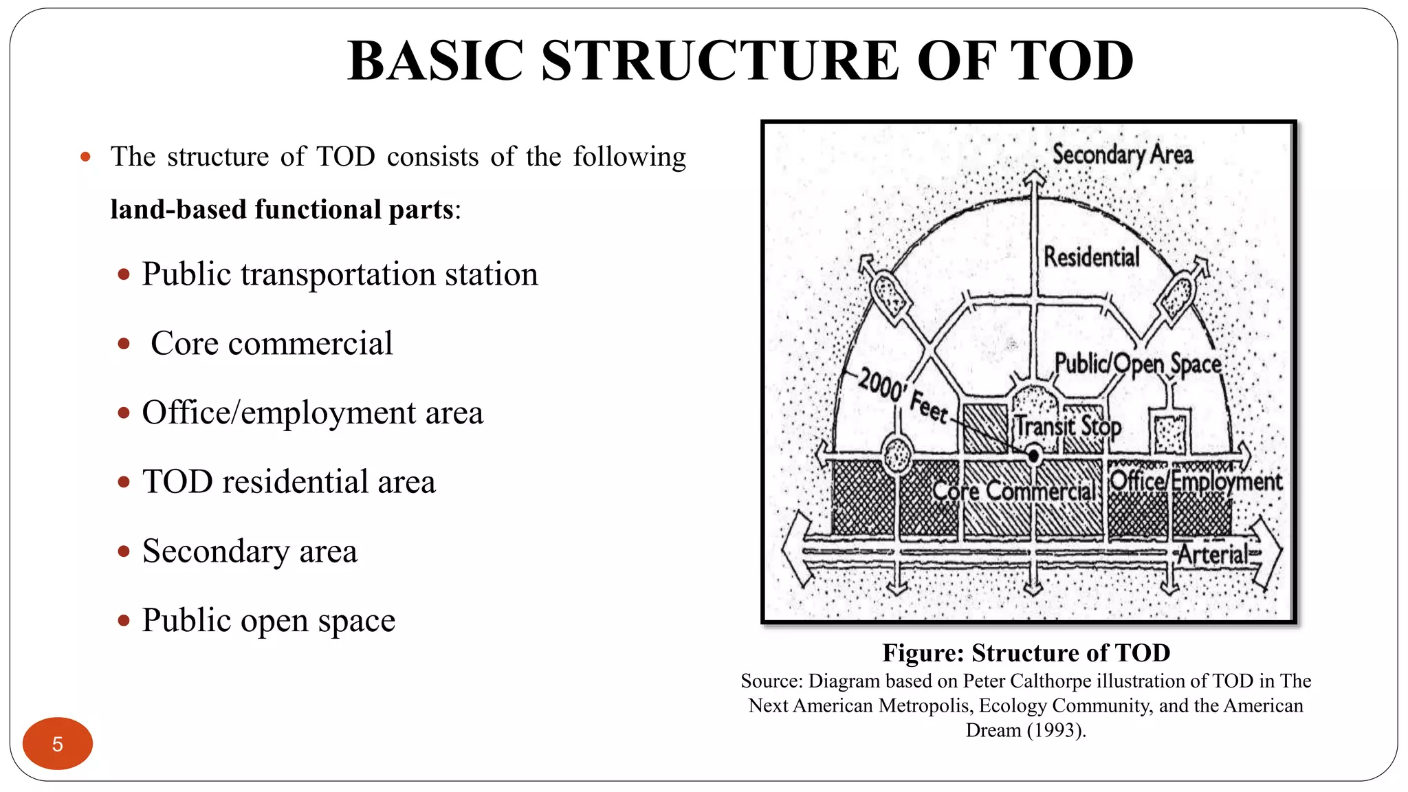
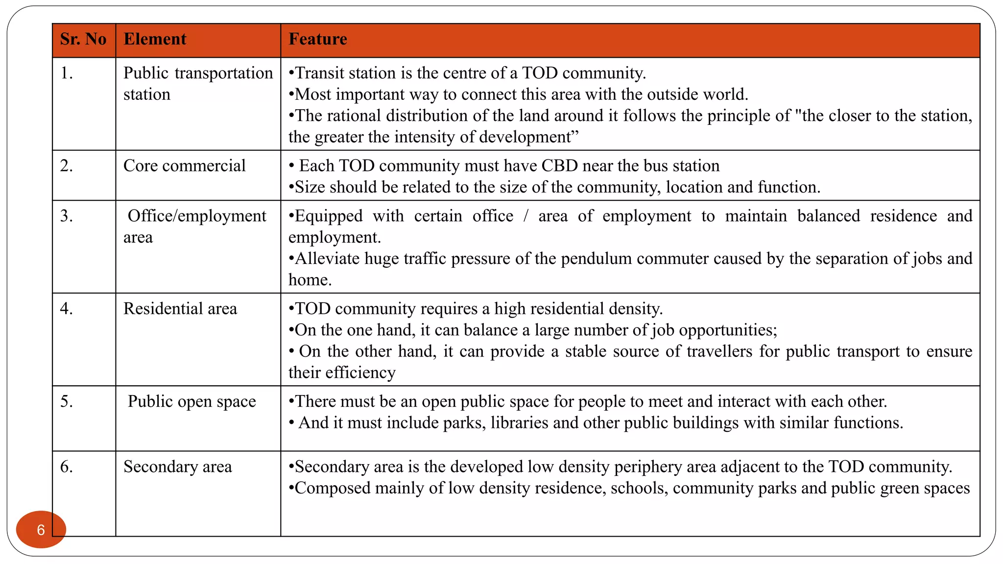
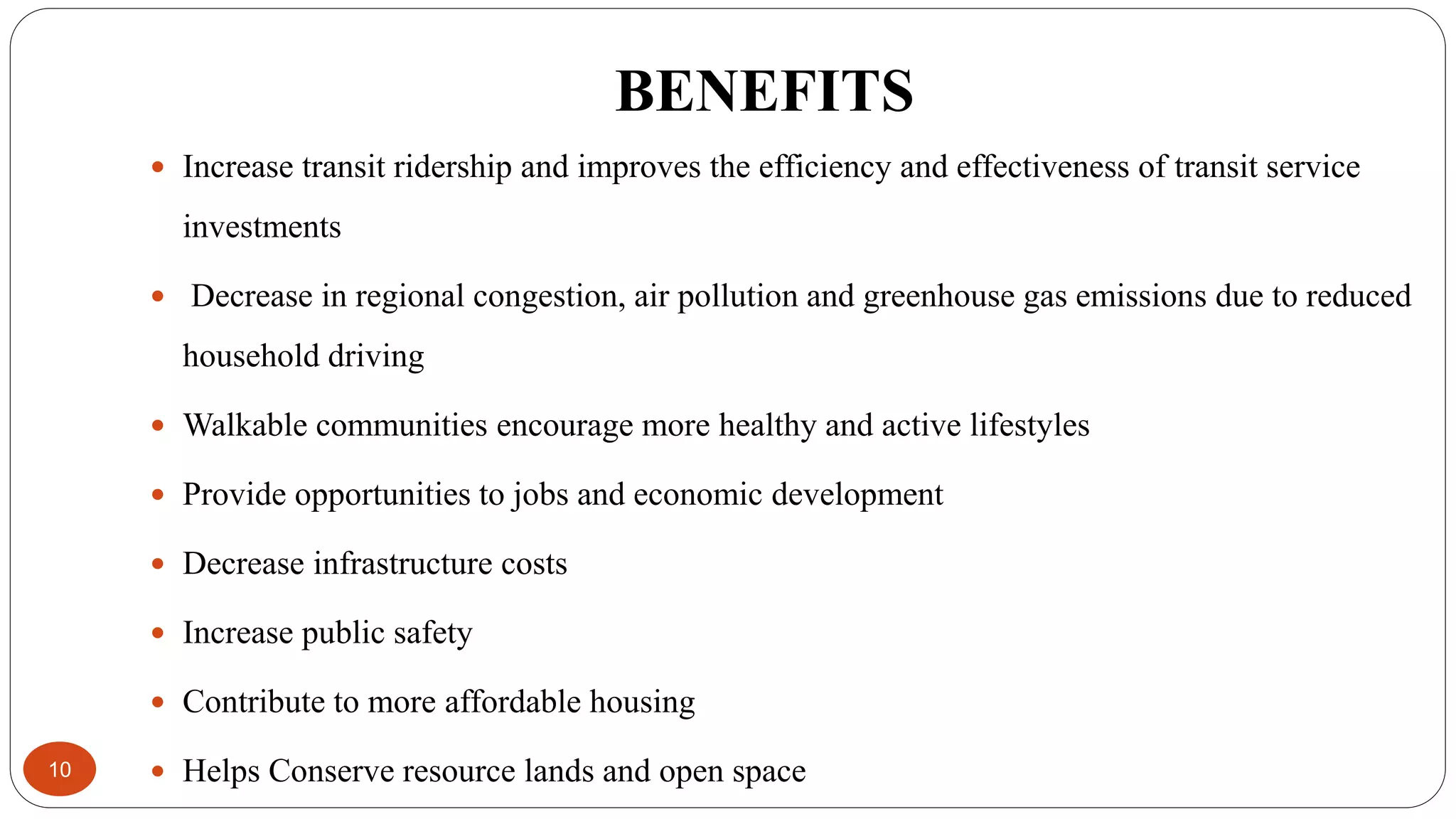
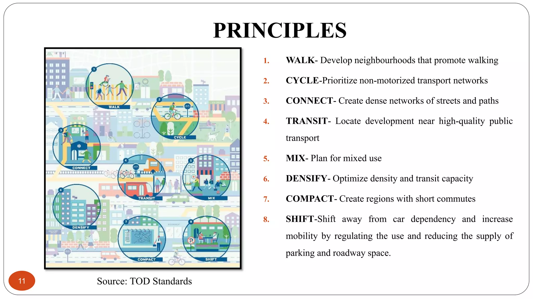
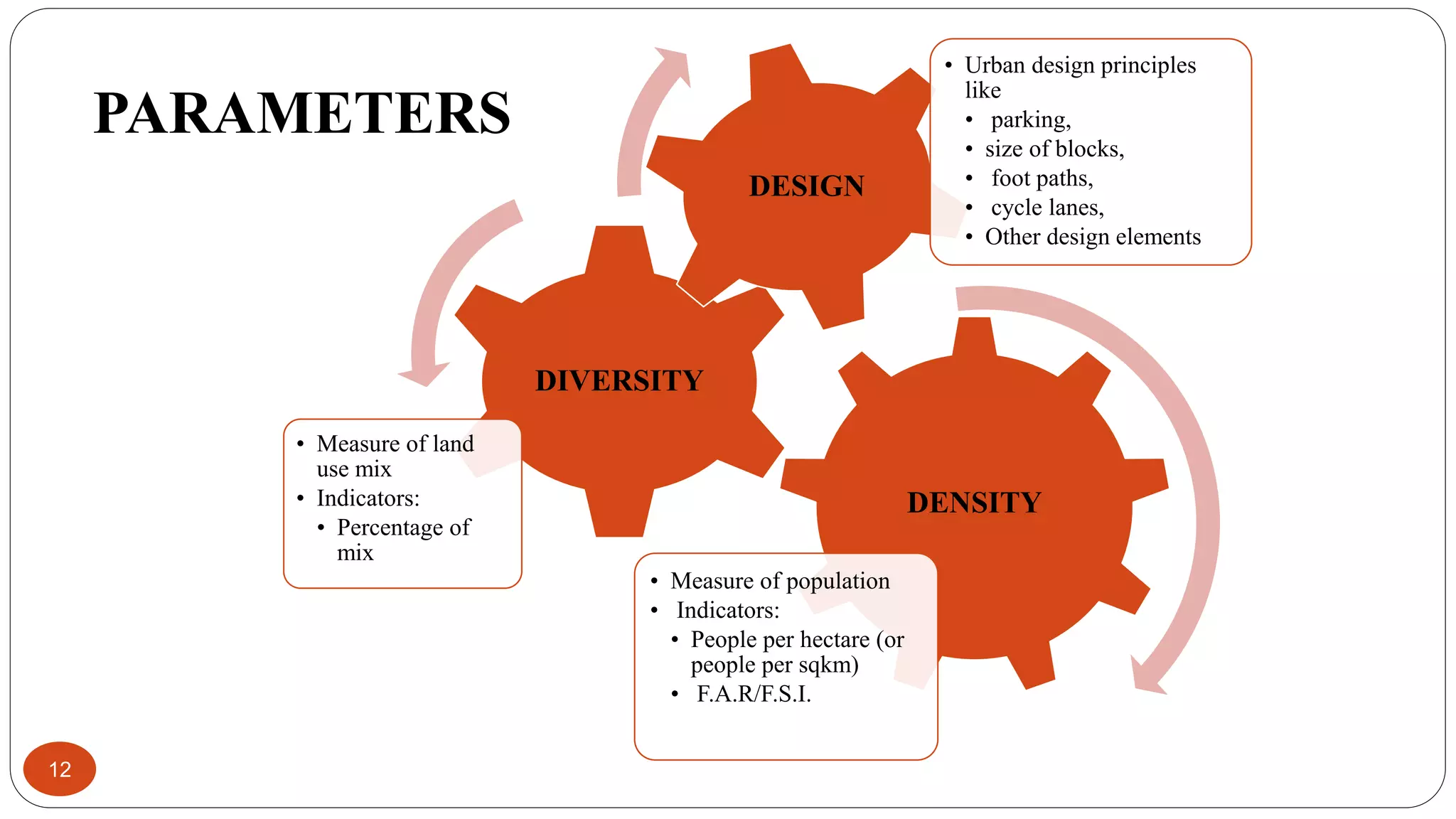
Graduate Report Presentation on
TRANSIT ORIENTED DEVELOPMENT (TOD)
ME – TCP, Year – I, Semester – I
Under the subject of
INFRASTRUCTURE & TRANSPORTATION PLANNING
(Subject Code : 3714803)
Prepared by :
JARIWALA POOJA
Enrollment No: 180420748006
Guided by :
Prof. Zarana H. Gandhi
Prof. Palak S. Shah
SARVAJANIK COLLEGE OF ENGINEERING & TECHNOLOGY, SURAT
FACULTY OF CIVIL ENGINEERING
MASTER OF ENGINEERING (TOWN AND COUNTRY PLANNING)
Affiliated with
GUJARAT TECHNOLOGICAL UNIVERSITY
Prof.(Dr.) Jigar K. Sevalia
Faculty & Head
Faculty of Civil Engineering, SCET
CONTENTS
2
 Introduction
 What is TOD?
 Basic Structure of TOD
 Types of TOD
 Benefits of TOD
 Principles of TOD
 Parameters
 Case Study-Curtiba,Brazil
 Conclusion
 References
INTRODUCTION
3
 With the acceleration of urbanization, the traditional mode of travel will gradually change to a
motorized mode, which will cause serious problems such as traffic congestion, environmental
pollution, low efficiency in land use and other related problems.
 It is important to use Public transportation such as MRTS and BRTS efficiently by integrating
land use with transportation infrastructure to make cities livable, healthy and smart.
 In order to ensure balance mode share with greater use of public transport, it is essential to
develop Transit Oriented Development for sustainable urban growth.
 The concept of TOD (Transit Oriented Development) is an evolution of urban planning
concept that emphasizes on the principles of integration between land use and
transportation.
 This concept is an elaboration of Smart Growth city concept that guides the development of
areas the heavy rail transit, light rail transit and bus transit stations and stops to improve the
accessibility of areas and to provide the ease of mobility.
What is TOD?
4
 TOD is typically identified as a high density area with mixed use (residential and
commercial), within walking distance of high capacity public transit station.
 TOD were firstly introduced in 1990by American architect and planner Peter Calthorpe.
 According to Peter Calthorpe, TOD are:
“Mixed-use community within an average 2,000- foot walking distance of a transit stop
and a core commercial area.”
 TODs mix residential,retail, office, open space, and public uses in a walkable environment,
making it convenient for residents and employees to travel by transit, bicycle, foot.
 TOD occurs within 1/4 to 1/2 mile or within a 5‐ to 10‐ minute walk, of a transit station.
BASIC STRUCTURE OF TOD
5
 The structure of TOD consists of the following
land-based functional parts:
 Public transportation station
 Core commercial
 Office/employment area
 TOD residential area
 Secondary area
 Public open space
Figure: Structure of TOD
Source: Diagram based on Peter Calthorpe illustration of TOD in The
Next American Metropolis, Ecology Community, and the American
Dream (1993).
6
Sr. No Element Feature
1. Public transportation
station
•Transit station is the centre of a TOD community.
•Most important way to connect this area with the outside world.
•The rational distribution of the land around it follows the principle of "the closer to the station,
the greater the intensity of development”
2. Core commercial • Each TOD community must have CBD near the bus station
•Size should be related to the size of the community, location and function.
3. Office/employment
area
•Equipped with certain office / area of ​​employment to maintain balanced residence and
employment.
•Alleviate huge traffic pressure of the pendulum commuter caused by the separation of jobs and
home.
4. Residential area •TOD community requires a high residential density.
•On the one hand, it can balance a large number of job opportunities;
• On the other hand, it can provide a stable source of travellers for public transport to ensure
their efficiency
5. Public open space •There must be an open public space for people to meet and interact with each other.
• And it must include parks, libraries and other public buildings with similar functions.
6. Secondary area •Secondary area is the developed low density periphery area adjacent to the TOD community.
•Composed mainly of low density residence, schools, community parks and public green spaces
7
TYPES
Node
TOD
Single
Node
Multi Node
Corridor
TOD
Single Node Multi Node
8
 Development takes place within a circle
centred on a transit station
 Circular pattern
 Radius varies from 0.5 km(pedestrian
access) to 2-3 km (bicycle access)
 Applicable in urban or suburban areas
Same as single node TOD but it reaches
further than a single location to create a
network of nodes
Beads-in-a-string pattern
Applicable to a region
Source: Past, Present And Future Of Transit-oriented Development In European City-regions,2016
CORRIDOR NODE
9
 Linear development along a transit line
with frequent stops
 Solid pattern because the nodes (i.e.
tram or BRT or Metro stops) are near
each other
 Applicable to an urban area (e.g. for
finger-like urban extension)
Source: Past, Present And Future Of Transit-oriented Development
In European City-regions,2016
BENEFITS
10
 Increase transit ridership and improves the efficiency and effectiveness of transit service
investments
 Decrease in regional congestion, air pollution and greenhouse gas emissions due to reduced
household driving
 Walkable communities encourage more healthy and active lifestyles
 Provide opportunities to jobs and economic development
 Decrease infrastructure costs
 Increase public safety
 Contribute to more affordable housing
 Helps Conserve resource lands and open space
PRINCIPLES
11
1. WALK- Develop neighbourhoods that promote walking
2. CYCLE-Prioritize non-motorized transport networks
3. CONNECT- Create dense networks of streets and paths
4. TRANSIT- Locate development near high-quality public
transport
5. MIX- Plan for mixed use
6. DENSIFY- Optimize density and transit capacity
7. COMPACT- Create regions with short commutes
8. SHIFT-Shift away from car dependency and increase
mobility by regulating the use and reducing the supply of
parking and roadway space.
Source: TOD Standards
12
DENSITY
• Measure of population
• Indicators:
• People per hectare (or
people per sqkm)
• F.A.R/F.S.I.
DIVERSITY
• Measure of land
use mix
• Indicators:
• Percentage of
mix
DESIGN
• Urban design principles
like
• parking,
• size of blocks,
• foot paths,
• cycle lanes,
• Other design elements
PARAMETERS
CASE STUDY – CURTIBA, BRAZIL
13
 The City of Curitiba is the capital of the Paraná state of Brazil. Curitiba is the largest city and
biggest economy in southern Brazil.
 In the 1960s, Curitiba already had a transport master plan in place and laid its first BRT line in
1974.
 As of now more than 75% percent people commute through its public transport. It is a
comprehensive plan which also focuses on the conjunction of transit oriented housing policies
and NMT within its plan itself.
 The current BRT system caters to more than 1.6million people and accounts for about 70% of
trips every day. The BRT system helped the city in reducing its air pollution tremendously;
lowered traffic jams and lowered per capita cost on transport.
14
 Curitiba has a trinary system where BRT routes run in one roadway in
the center with private vehicles on either side and 2 roads on either side
of the main corridor cater to private vehicles.
 The trinary system caters to high density land use along the roads with
feeder lines connect-ing the main corridors.
 The buildings facing the transit corridors need to be high rise with mixed
building use which means they need to have at least half the ground floor
and second floors to be of commercial use.
 Beyond the private vehicle roadway, residential areas are zoned and
taper down in density as the distance increases from the main transit
corridor.
 Some of the transit supportive housing policies include a ‘buy up’ for
developers who can build two extra floors of residential buildings by
contributing to a low income housing fund which are granted to
residential parcels in the ZR4, ZR3 and ZR2 zones which lie within
walking distance of the transit way.
15
Source: 10th Urban Mobility Conference and Expo,2017,Centre of Excellence in Urban
Transport
CONCLUSION
16
 Future developments and the evolution of morden cities require a perspective of
sustainable development and integrated management of existing resources.
 TOD can be used as a strategy to solve the existing problem of traffic congestion,
environmental pollution, low efficiency in land use and problems of urban growth for all
kinds of cities.
 TOD will generally be adopted as a real option for car-oriented urban planning and design.
 In the aspect of land use structure, TOD encourages mixed land use, including planar
mixed use and vertical mixed use, to reduce travel demand.
REFERENCES
17
 Calthorpe, Peter. 1993. The Next American Metropolis: Ecology, Community, and the
American Dream. Princeton Architectural Press
 10th Urban Mobility Conference and Expo,2017,Centre of Excellence in Urban
Transport
 TOD Standards
 Past, Present And Future Of Transit-oriented Development In European City-
regions,2016
 A. Sahu, A methodology to modify land uses in a transit oriented development scenario,
Journal of Environmental Management,Volume 213, 467-477,2018
18

Transit oriented development

  • 1.
    Graduate Report Presentationon TRANSIT ORIENTED DEVELOPMENT (TOD) ME – TCP, Year – I, Semester – I Under the subject of INFRASTRUCTURE & TRANSPORTATION PLANNING (Subject Code : 3714803) Prepared by : JARIWALA POOJA Enrollment No: 180420748006 Guided by : Prof. Zarana H. Gandhi Prof. Palak S. Shah SARVAJANIK COLLEGE OF ENGINEERING & TECHNOLOGY, SURAT FACULTY OF CIVIL ENGINEERING MASTER OF ENGINEERING (TOWN AND COUNTRY PLANNING) Affiliated with GUJARAT TECHNOLOGICAL UNIVERSITY Prof.(Dr.) Jigar K. Sevalia Faculty & Head Faculty of Civil Engineering, SCET
  • 2.
    CONTENTS 2  Introduction  Whatis TOD?  Basic Structure of TOD  Types of TOD  Benefits of TOD  Principles of TOD  Parameters  Case Study-Curtiba,Brazil  Conclusion  References
  • 3.
    INTRODUCTION 3  With theacceleration of urbanization, the traditional mode of travel will gradually change to a motorized mode, which will cause serious problems such as traffic congestion, environmental pollution, low efficiency in land use and other related problems.  It is important to use Public transportation such as MRTS and BRTS efficiently by integrating land use with transportation infrastructure to make cities livable, healthy and smart.  In order to ensure balance mode share with greater use of public transport, it is essential to develop Transit Oriented Development for sustainable urban growth.  The concept of TOD (Transit Oriented Development) is an evolution of urban planning concept that emphasizes on the principles of integration between land use and transportation.  This concept is an elaboration of Smart Growth city concept that guides the development of areas the heavy rail transit, light rail transit and bus transit stations and stops to improve the accessibility of areas and to provide the ease of mobility.
  • 4.
    What is TOD? 4 TOD is typically identified as a high density area with mixed use (residential and commercial), within walking distance of high capacity public transit station.  TOD were firstly introduced in 1990by American architect and planner Peter Calthorpe.  According to Peter Calthorpe, TOD are: “Mixed-use community within an average 2,000- foot walking distance of a transit stop and a core commercial area.”  TODs mix residential,retail, office, open space, and public uses in a walkable environment, making it convenient for residents and employees to travel by transit, bicycle, foot.  TOD occurs within 1/4 to 1/2 mile or within a 5‐ to 10‐ minute walk, of a transit station.
  • 5.
    BASIC STRUCTURE OFTOD 5  The structure of TOD consists of the following land-based functional parts:  Public transportation station  Core commercial  Office/employment area  TOD residential area  Secondary area  Public open space Figure: Structure of TOD Source: Diagram based on Peter Calthorpe illustration of TOD in The Next American Metropolis, Ecology Community, and the American Dream (1993).
  • 6.
    6 Sr. No ElementFeature 1. Public transportation station •Transit station is the centre of a TOD community. •Most important way to connect this area with the outside world. •The rational distribution of the land around it follows the principle of "the closer to the station, the greater the intensity of development” 2. Core commercial • Each TOD community must have CBD near the bus station •Size should be related to the size of the community, location and function. 3. Office/employment area •Equipped with certain office / area of ​​employment to maintain balanced residence and employment. •Alleviate huge traffic pressure of the pendulum commuter caused by the separation of jobs and home. 4. Residential area •TOD community requires a high residential density. •On the one hand, it can balance a large number of job opportunities; • On the other hand, it can provide a stable source of travellers for public transport to ensure their efficiency 5. Public open space •There must be an open public space for people to meet and interact with each other. • And it must include parks, libraries and other public buildings with similar functions. 6. Secondary area •Secondary area is the developed low density periphery area adjacent to the TOD community. •Composed mainly of low density residence, schools, community parks and public green spaces
  • 7.
  • 8.
    Single Node MultiNode 8  Development takes place within a circle centred on a transit station  Circular pattern  Radius varies from 0.5 km(pedestrian access) to 2-3 km (bicycle access)  Applicable in urban or suburban areas Same as single node TOD but it reaches further than a single location to create a network of nodes Beads-in-a-string pattern Applicable to a region Source: Past, Present And Future Of Transit-oriented Development In European City-regions,2016
  • 9.
    CORRIDOR NODE 9  Lineardevelopment along a transit line with frequent stops  Solid pattern because the nodes (i.e. tram or BRT or Metro stops) are near each other  Applicable to an urban area (e.g. for finger-like urban extension) Source: Past, Present And Future Of Transit-oriented Development In European City-regions,2016
  • 10.
    BENEFITS 10  Increase transitridership and improves the efficiency and effectiveness of transit service investments  Decrease in regional congestion, air pollution and greenhouse gas emissions due to reduced household driving  Walkable communities encourage more healthy and active lifestyles  Provide opportunities to jobs and economic development  Decrease infrastructure costs  Increase public safety  Contribute to more affordable housing  Helps Conserve resource lands and open space
  • 11.
    PRINCIPLES 11 1. WALK- Developneighbourhoods that promote walking 2. CYCLE-Prioritize non-motorized transport networks 3. CONNECT- Create dense networks of streets and paths 4. TRANSIT- Locate development near high-quality public transport 5. MIX- Plan for mixed use 6. DENSIFY- Optimize density and transit capacity 7. COMPACT- Create regions with short commutes 8. SHIFT-Shift away from car dependency and increase mobility by regulating the use and reducing the supply of parking and roadway space. Source: TOD Standards
  • 12.
    12 DENSITY • Measure ofpopulation • Indicators: • People per hectare (or people per sqkm) • F.A.R/F.S.I. DIVERSITY • Measure of land use mix • Indicators: • Percentage of mix DESIGN • Urban design principles like • parking, • size of blocks, • foot paths, • cycle lanes, • Other design elements PARAMETERS
  • 13.
    CASE STUDY –CURTIBA, BRAZIL 13  The City of Curitiba is the capital of the Paraná state of Brazil. Curitiba is the largest city and biggest economy in southern Brazil.  In the 1960s, Curitiba already had a transport master plan in place and laid its first BRT line in 1974.  As of now more than 75% percent people commute through its public transport. It is a comprehensive plan which also focuses on the conjunction of transit oriented housing policies and NMT within its plan itself.  The current BRT system caters to more than 1.6million people and accounts for about 70% of trips every day. The BRT system helped the city in reducing its air pollution tremendously; lowered traffic jams and lowered per capita cost on transport.
  • 14.
    14  Curitiba hasa trinary system where BRT routes run in one roadway in the center with private vehicles on either side and 2 roads on either side of the main corridor cater to private vehicles.  The trinary system caters to high density land use along the roads with feeder lines connect-ing the main corridors.  The buildings facing the transit corridors need to be high rise with mixed building use which means they need to have at least half the ground floor and second floors to be of commercial use.  Beyond the private vehicle roadway, residential areas are zoned and taper down in density as the distance increases from the main transit corridor.  Some of the transit supportive housing policies include a ‘buy up’ for developers who can build two extra floors of residential buildings by contributing to a low income housing fund which are granted to residential parcels in the ZR4, ZR3 and ZR2 zones which lie within walking distance of the transit way.
  • 15.
    15 Source: 10th UrbanMobility Conference and Expo,2017,Centre of Excellence in Urban Transport
  • 16.
    CONCLUSION 16  Future developmentsand the evolution of morden cities require a perspective of sustainable development and integrated management of existing resources.  TOD can be used as a strategy to solve the existing problem of traffic congestion, environmental pollution, low efficiency in land use and problems of urban growth for all kinds of cities.  TOD will generally be adopted as a real option for car-oriented urban planning and design.  In the aspect of land use structure, TOD encourages mixed land use, including planar mixed use and vertical mixed use, to reduce travel demand.
  • 17.
    REFERENCES 17  Calthorpe, Peter.1993. The Next American Metropolis: Ecology, Community, and the American Dream. Princeton Architectural Press  10th Urban Mobility Conference and Expo,2017,Centre of Excellence in Urban Transport  TOD Standards  Past, Present And Future Of Transit-oriented Development In European City- regions,2016  A. Sahu, A methodology to modify land uses in a transit oriented development scenario, Journal of Environmental Management,Volume 213, 467-477,2018
  • 18.