Download to read offline
![AddressingHistory - Crowdsourcing the Past Stuart Macdonald Associate Data Librarian EDINA & Data Library University of Edinburgh [email_address] Association of American Geographers Annual Meeting - Working Digitally with Historical Maps, New York Public Library, 25 Feb. 2012](https://image.slidesharecdn.com/35macdonald-120302053212-phpapp02/85/AddressingHistory-crowdsourcing-the-past-1-320.jpg)
![AddressingHistory - Crowdsourcing the Past Stuart Macdonald Associate Data Librarian EDINA & Data Library University of Edinburgh [email_address] Association of American Geographers Annual Meeting - Working Digitally with Historical Maps, New York Public Library, 25 Feb. 2012](https://image.slidesharecdn.com/35macdonald-120302053212-phpapp02/75/AddressingHistory-crowdsourcing-the-past-1-2048.jpg)

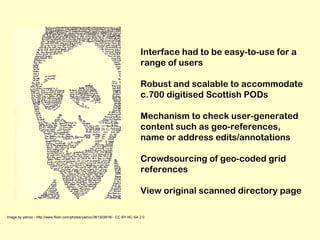
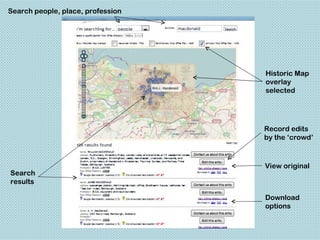

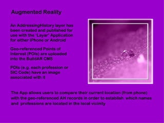
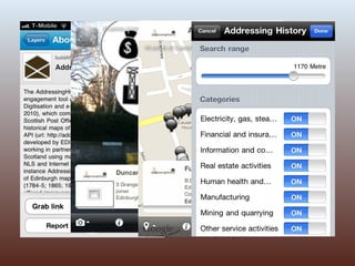

The AddressingHistory project, funded by JISC, aims to create an online crowdsourcing tool that combines digitized historical Scottish post office directories with historical maps for public collaboration in enhancing historical data. The project highlights the importance of community participation in georeferencing historical entries and improving old records using user-generated content, with a focus on sustainability and broader application potential. Future phases will include augmented reality features and additional content to promote continued engagement and usability in various communities.


