Presentation given by Stuart Macdonald on Addressing History at RunCoCo workshop: Community Collection Online - sustainability and business models, University of Leeds, 3 November 2010
The document discusses two phases of the AddressingHistory project, which aimed to crowdsource the georeferencing of historical Scottish Post Office Directories. Phase 1 focused on creating an online tool to allow users to georeference directories from 1784-1885 and 1905-1906. Phase 2 expanded the tool's functionality and added content from 1881-1891. The project demonstrated how crowdsourcing could be used at both the individual record level and higher levels to improve optical character recognition of directories and make the historical data more accessible and searchable.
This document summarizes the AddressingHistory project, which created an online crowdsourcing tool combining digitized historical Scottish Post Office Directories (PODs) with historical maps. The project had two phases: the first created the initial tool using three POD volumes from 1784-1805, 1865, and 1905-1906. The second phase expanded coverage to additional years and locations, improved parsing of names and occupations, and added new search and visualization features. Lessons learned included the need for ongoing refinement, sustainability planning, and engagement of relevant communities.
Fieldtrip GB is a customisable mobile app for collecting mapping and field data. It allows users to [1] save maps for offline use, [2] create custom data collection forms, and [3] search, filter and export collected records. Developing such apps faces challenges like cost, rapid technology changes, and supporting multiple platforms/networks. The app addresses issues with open data mashups like labeling conflicts and alignment. It uses a client-server architecture with PhoneGap, OpenLayers and outsourced data storage. Future plans include more data types and augmented reality. The app aims to empower users and contribute to the "Sensed World Web".
Big Just Got Bigger! discusses the challenges of managing large map collections through the Digimap service. Digimap provides access to geospatial data from various sources, including Ordnance Survey, British Geological Survey, aerial imagery, and more. It has grown significantly over time to include more data sources and users. Managing such large datasets and meeting user expectations of current data and performance presents challenges. Issues include keeping data current while sharing across platforms, disk storage needs increasing exponentially over time, and ensuring data can be accessed and used through various tools and formats.
The document discusses metadata and geospatial data management. It describes the purpose of metadata including protecting investments in data creation and ensuring data integrity. It also outlines challenges in sharing geospatial data and standards for metadata including ISO and INSPIRE. Tools are presented for creating UK and INSPIRE compliant metadata including Geodoc, an online metadata editor, and publishing metadata through the GoGeo portal.
1) Postgres and PostGIS have been used at EDINA for over 8 years to power major geospatial services like Digimap.
2) It is used for data storage, mapping, spatial indexing, querying, and data downloads. Postgres allows EDINA to handle large amounts of geospatial data and large user bases.
3) EDINA finds Postgres reliable, performant, scalable, and standards-compliant with good support tools. It will continue being the core database for EDINA's geoservices.
Delivered by Peter Burnhill at Text Mining for Scholarly Communications and Repositories Joint Workshop, Manchester Interdisciplinary Biocentre, University of Manchester, 28-29 October 2009
EDINA is a national data center based at the University of Edinburgh that provides open access to scholarly resources and supports the UK education sector. It runs several geospatial services including GeoTagger for geotagging images, Cartogrammar for creating cartograms, GoGeo for discovering GIS resources and metadata, Unlock for georeferencing text, and ShareGeo and Openstream for mapping and sharing open geospatial data. EDINA also promotes open events and groups for geospatial topics.
Presented by Tony Mathys at a Current Issues and Applications of the Geospatial Technologies Lecture, Department of Geography and Environment, Aberdeen University, 24 February 2012
This document discusses geospatial APIs and mapping libraries. It introduces some major geospatial APIs from Google, Bing, and Here that provide map data and services. It also describes two popular mapping libraries - Leaflet and OpenLayers. Leaflet is easy to use but less flexible, while OpenLayers is more powerful but more complex. The document also discusses how geospatial data isn't limited to maps and can include data that references locations, and describes technologies for extracting location references from text.
Edinburgh DataShare is a digital repository hosted by the University of Edinburgh's Data Library that stores and shares multi-disciplinary research datasets. It was developed using DSpace software with customizations to support different file types and metadata standards for various research domains. The Data Library engages with researchers through training, reference support, and projects to understand their data needs and improve data management, sharing and preservation services.
1. The document discusses the development of JISC Mediahub, a new platform that will aggregate and provide access to various digital media collections from different sources.
2. JISC Mediahub will allow users to search across collections in one place and stream or download content depending on licensing.
3. An initial preview version of JISC Mediahub has been launched, allowing users to search metadata and view some content. The full service is planned for launch in August.
The MIMAS workshop discussed the RepositoryNet infrastructure and components including aggregation, text mining, search, benchmarking and statistics, registries, deposit tools, and metadata quality. It provided updates on components outside RepositoryNet like IRS Search and NAMES 2. A demonstration of IRUS showed its current functionality for benchmarking and statistics and future plans for funding, APIs, international scope, and business models. Developing service level agreements for RepNet services was also discussed.
Collaboration to Curation: The High Rise Project meets Edinburgh DataShare University of Edinburgh
Slides describing the evolution of the Edinburgh DataShare repository and The High-Rise Project and the (potential) collaborative mechanisms that will enable the digital content to be ingested and preserved in the Edinburgh DataShare DSpace repository environment
The document discusses various online tools for visualizing and sharing data on the participatory web. It provides examples of tools for mapping and spatial data visualization, including ProgrammableWeb, GeoCommons, and OpenStreetMap. It also lists tools for numeric data visualization like Graphwise, Numbrary, and Swivel. The document questions whether these types of online data visualization tools are just a temporary phenomenon or have more lasting potential to support academic research and open data initiatives.
This document discusses challenges with curating and sharing research data to support reuse. It notes that while the amount of digital research data being created is growing rapidly, current systems for preserving data are not optimally designed with input from researchers. Researchers have various concerns about openly sharing their data that need to be addressed. Studies found that engaging researchers early and building trusted relationships is important for developing effective data curation solutions tailored to different research practices and disciplines.
LoCloud - Local content in a Europeana cloudEuropeana
1. LoCloud is an EU-funded project that aims to make it easier for small and medium institutions to contribute content to Europeana by exploring cloud computing solutions for aggregation, enrichment, and reuse of content.
2. The project will develop an enhanced cloud-based aggregation infrastructure and a suite of software-as-a-service tools for geolocation enrichment, metadata enrichment, multilingual vocabularies, and more.
3. It brings together a consortium of technical partners and content providers across Europe to pilot these cloud services and help more institutions make their local history and heritage resources discoverable through Europeana.
The document outlines a plan to 1) develop structured databases to store and share environmental and socio-economic data for managing Albania's protected area network, 2) make biodiversity data interoperable with global facilities, and 3) build an effective long-term monitoring system to regularly update the databases. It proposes using international standards for data collection and sharing, as well as web-GIS software and data sharing protocols. Additionally, it suggests establishing a network of institutions to collect, maintain and update the database content and ensure scientific rigor.
Presented by Peter Burnhill at e-Journals are forever? Preservation and Continuing Access to e-journal Content. A DPC, EDINA and JISC joint initiative, British Library, London, 26 April 2010.
Presentation by Daniele Bailo, INGV, Italy
EPOS has been designed with the vision of creating a pan-European infrastructure for solid Earth science to support a safe and sustainable society. In accordance with this scientific vision, the EPOS mission is to integrate the diverse and advanced European Research Infrastructures for solid Earth science relying on new e-science opportunities to monitor and unravel the dynamic and complex Earth System. EPOS will enable innovative multidisciplinary research for a better understanding of the Earth’s physical and chemical processes that control earthquakes, volcanic eruptions, ground instability and tsunami as well as the processes driving tectonics and Earth’s surface dynamics. To accomplish its mission, EPOS is engaging different stakeholders, not limited to scientists, to allow the Earth sciences to open new horizons in our understanding of the planet. Through integration of data, models and facilities, EPOS will allow the Earth science community to make a step change in developing new concepts and tools for key answers to scientific and socio-economic questions concerning geo-hazards and geo-resources as well as Earth sciences applications to the environment and human welfare.
ICOS: Integrated Carbon Observation System Open data to open our eyes to clim...Blue BRIDGE
Presentation by Harry Lankreijer, ICOS-Carbon Portal, Lund University, Sweden.
ICOS is a pan-European research infrastructure (RI) for observing and understanding the greenhouse gas (GHG) balance of Europe and its adjacent regions. The major task of ICOS is to collect and make available in a transparent manner, the high-quality observational data from its state-of-the-art measurement stations. These ICOS data – from atmosphere, ecosystem and ocean stations – will contribute to research aiming to describe and understand the present state of the global carbon cycle. The Carbon Portal will be the virtual data center that present the data products and make it available. This presentation will briefly present the work of ICOS and the Carbon Portal towards open data with FAIR principles. ICOS has an open data policy with free use, requesting the user to give appropriate credit (Creative Commons Attribution 4.0 ). The Carbon Portal is developing a data catalogue using an ontology based on a semantic metadata description. This will make it possible to integrate ICOS observations with data from other RI’s as well with data of global networks. For integration, the Carbon Portal is actively following the developments of international standards for eg. metadata and data citation.
Sharing irish place names as linked open data - Rebecca Grantdri_ireland
Overview of the collaborative project 'Linked Logainm', which made the authoritative bilingual database of Irish place names, logainm.ie, available as Linked Open Data.
The document describes the GeoKnow project, an EU-funded project from 2012-2015 that aimed to make geospatial data on the web more explorable. It developed techniques for aggregating, linking, and improving the quality of spatial data from various sources. This included mapping implicit geographic references in data, fusing data with differences, and assessing crowdsourced information. It created tools for visualizing and authoring spatial semantic data, as well as applying the work to supply chain management and e-commerce use cases. The project was a collaboration between several European organizations focused on advancing the representation and use of geospatial knowledge on the semantic web.
The document summarizes a meeting at the University of Edinburgh about library roles in research data management. It includes:
- Welcome and introduction from Robin Rice about data library services and projects related to research data management.
- A talk from Sam Searle of Monash University about library roles in research data management based on experiences at Monash.
- A discussion session.
- A presentation by Sheila Cannell about getting a research data management policy for the University of Edinburgh.
- A presentation by Jeff Haywood about the University of Edinburgh's storage strategy.
COBWEB presentation given at the Citizens' Observatories: Empowering European Society Open Conference, which took place on 4th December 2014, Brussels, Belgium.
CLOCKSS is a community-based digital preservation system that aims to solve the problem of loss of digital content that is no longer available in print. It works by storing copies of content across global partner libraries. Content is governed by an international board of libraries and publishers. CLOCKSS uses a sustainable financial model of low fees and raising an endowment to keep participation affordable and ensure long-term preservation of orphaned digital content.
The PEPRS project aims to create a registry of e-journal archiving activities to help libraries assess digital preservation of e-journals. Phase 1 involved piloting a database of e-journals archived by 4 digital preservation agencies and national libraries. This identified issues around inconsistent ISSNs, holdings information, and terminology. Phase 2 will further develop the registry service and involve international users in testing to help establish governance. The registry will provide a searchable list of e-journals and details on what organizations are preserving which volumes and under what terms of access.
The document provides an overview of the Statistical Accounts of Scotland, a survey of Scottish parishes from 1791-1845. It describes the origins of the Accounts under Sir John Sinclair in the late 18th century. It details the questions parish ministers were asked to compile statistical, economic and social information. The Accounts provide an extraordinary view of life in Scottish parishes. The digitized Accounts online allow searching of text and images from over 28,000 pages describing hundreds of parishes.
Part of collaborative citizen science presentation with James Stewart and co-developed with Eugenia Rodrigues, for the UoE Institute for Study of Science, Technology and Innovation Retreat. 9th June 2015.
The document summarizes RDM Roadmap@Edinburgh, an institutional approach to research data management at the University of Edinburgh. It provides background on a 2008 data audit that identified a need for RDM guidance, training, policy, and services. It then outlines the context, drivers, and implementation committee behind the University's RDM policy. The roadmap itself sets strategic objectives and deliverables across four areas - data management planning, active data infrastructure, data stewardship, and data management support - from 2012-2014. It notes next steps around costing, piloting activities, and training to improve alignment with stakeholders.
This document provides guidance on using social media to communicate research work. It recommends considering goals and target audiences when planning social media use. Popular tools like blogs, Twitter, YouTube, and Flickr are discussed as ways to share updates, build networks, and engage audiences. Both barriers and appropriate content for social media are addressed. In particular, the document advises checking privacy and disclosure policies, and avoiding sharing sensitive or unprofessional information.
Building research data management services at the University of Edinburgh: a ...Robin Rice
This document discusses building research data management services from a data librarian's perspective. It defines research data management and outlines developing an institutional RDM policy involving researchers, librarians, and IT staff. The author discusses the University of Edinburgh's library-led RDM policy as an example. The document also covers supporting researchers through training, guidance, and tools for data management planning and sharing. It proposes additional library RDM services like data repositories, archiving, and metadata standards expertise. Challenges for librarians expanding into this new domain are also addressed.
Stuart Macdonald talks about the Research Data Management programme at the University of Edinburgh Data Library, delivered at the ADP Workshop for Librarians: Open Research Data in Social Sciences and Humanities (ADP), Ljubljana, Slovenia, 18 June 2014
1) The document discusses roles and responsibilities in ensuring permanent access to scholarly works.
2) It notes that while access to works has improved online, continuity of access is challenged as content can disappear from the web.
3) The document reports on measured progress in archiving journal content through organizations like CLOCKSS and Portico, but notes that only 19% of identified online journals are currently being preserved.
This document discusses three outputs from a project exploring methods for authorizing access to web services through federated identity systems:
1. A modified Digimap production service that provides access to geospatial data via OGC standards using UK federation single sign-on for registered users.
2. Instructions for a simple method to control access to existing web services from non-browser clients without modifying the web service, using Apache and scripting.
3. A demonstration of deploying new Shibboleth delegation software to allow a JSP to access a web service after authenticating with an identity provider without additional logins.
The Cartogrammar project aimed to increase access and use of cartograms by developing an easy-to-use online cartogram generation tool. It created a robust application programming interface (API) and accompanying website to allow non-experts to generate and customize cartograms without needing specialized software or computational resources. The site includes an interface for generating bespoke cartograms, a gallery of user-submitted cartograms, and an embeddable widget so users can add cartogram generation to their own websites. This overcomes previous barriers to cartogram use related to complexity and computing requirements.
presented by Stuart Macdonald at the College of Science and Engineering - "What's new for you in the Library“, Murray Library, Kings Buildings, University of Edinburgh. 28 May 2014
Covers research data, research data management, funder policies and the University's RDM policy, RDM services and support, awareness raising, training, progress so far.
1. Edinburgh DataShare is a data repository service at the University of Edinburgh that allows researchers to upload, share, and license their research data.
2. It was built using DSpace in 2007-2009 as part of a project to create exemplar institutional data repositories.
3. The repository staff have worked to meet the needs of different research communities piloting data deposits, including large video and software files, sensitive health data, and arts data requiring specialized display.
Presenter: Stuart Macdonald
Presentation first given at Open Knowledge Scotland event at Inspace in Edinburgh, 13 May 2010.
EDINA project to create an online crowdsourcing tool which will combine data from digitised Scottish Post Office Directories (PODs) with contemporaneous historical maps
The document describes the Old Maps Online project, which aims to create a global search portal for geo-referenced historical maps. It is funded by JISC and involves the University of Portsmouth, Klokan Technologies GmbH, the British Library, and the National Library of Scotland. The portal allows users to intuitively search maps by location and view high-resolution zoomable maps from participating institutions with proper attribution. The project seeks to promote map libraries and make more maps discoverable online.
AddressingHistory - Crowdsourcing the Past - Stuart MacdonaldJISC GECO
Presentation given at the Geospatial in the Cultural Heritage Domain - Past, Present & Future event in London on 7th March 2012. The event was organised as part of the JISC GECO project.
The document summarizes the AddressingHistory project, which aims to crowdsource the geocoding of historical Scottish postal directories by having users link directory entries to digitized historical maps. The project partnered with the National Library of Scotland to digitize directories from 1784-1805, 1865, and 1905-1906. It will develop an online tool allowing users to georeference directory entries by placing pins on digitized maps. The project will focus on engagement through social media channels and its blog. It recently launched its online tool and API and is now focused on sustainability and funding.
This presentation introduces OWLIM semantic repository at DM2E project meeting, held in Vienna in November 2012. Ontotext entered the DM2E consortium as associated partner.
Ontotext is a leading provider of semantic technology solutions, including their OWLIM semantic database. OWLIM can handle large RDF datasets with scalable reasoning and high performance querying. It has been used successfully in cultural heritage domains by organizations like the BBC and British Museum to power semantic search and knowledge bases. OWLIM supports RDFS/OWL reasoning, spatial indexing, replication for high availability, and ranking of nodes based on semantic relationships.
This document summarizes a presentation given by Mariana Damova on using semantic technologies and Europeana data. It discusses how Europeana data has been converted to RDF and loaded into the OWLIM semantic graph database. This allows linking Europeana data to other datasets to enable queries across multiple sources. Examples of queries over Europeana and other cultural heritage data are provided. Future work on projects like Europeana Creative is also mentioned.
Managing director of Klokan Technologies GmbH, a small Swiss company that develops innovative geo applications for cultural heritage institutions. The document discusses Old Maps Online, a project that provides an easy-to-use gateway for searching historical maps from libraries around the world. It allows users to search maps by geographic location on an interactive world map and view high resolution maps from contributing institutions with proper crediting back to the libraries. The project is open to additional map contributors and uses tools like BoundingBox and Georeferencer to help enrich map metadata.
The National Library of Scotland (NLS) developed an API to promote use of its historical maps in online mashups. The API has been successful, with over 840,000 visits since 2010. It allows easy embedding of NLS maps into third-party websites and mobile apps. Various communities have used the maps for outdoor activities, photography, archaeology, genealogy and more. The API relies on tile server technology to serve seamless maps rendered from large geospatial files. The NLS continues to add new historical map layers and support the growing user base.
The document discusses the development of the CARARE 2.0 metadata schema. The schema was updated based on lessons learned from supplying data to Europeana and requirements for documenting 3D content from projects like 3D-ICONS. The main changes in CARARE 2.0 include broadening the "Heritage Asset" scope, simplifying references and provenance, and adding elements to document activities, provenance, and paradata needed for quality 3D models. The schema distinguishes heritage assets, digital resources, and activities, and allows them to be related to fully document objects and their digital surrogates.
This document discusses creating a knowledge graph for Irish history as part of the Beyond 2022 project. It will include digitized records from core partners documenting seven centuries of Irish history. Entities like people, places, and organizations will be extracted from source documents and related in a knowledge graph using semantic web technologies. An ontology was created to provide historical context and meaning to the relationships between entities in Irish history. Tools will be developed to explore and search the knowledge graph to advance historical research.
The British Library, London: Old Maps OnlinePetr Pridal
Petr Pridal is the managing director of Klokan Technologies GmbH, a small Swiss company that develops geospatial applications for cultural heritage institutions. Klokan Technologies created Old Maps Online, a portal that allows users to search historical maps from libraries around the world by geographic location. The project aims to make these maps more accessible online and promote the map collections of participating institutions. Klokan Technologies is seeking help from institutions to contribute additional maps to the portal and provide feedback to further improve the technology.
Linked Open Data and The Digital Archaeological Workflow at the Swedish Natio...Marcus Smith
A presentation of two aspects of the linked open data work ongoing at the Swedish National Heritage Board (Riksantikvarieämbetet): Swedish Open Cultural Heritage (SOCH/K-samsök) and the Digital Archaeological Process (DAP).
Delivered at the Smithsonian, Washington, DC, 2014-11-10
CartoHeritage 2011: Georeferencer & MapRank SearchPetr Pridal
Presentation from the workshop: Digital Approaches in Cartographic Heritage 2011: 6th International Workshop, The Hague, 7-8 April 2011.
http://xeee.web.auth.gr/ICA-Heritage/Commission/6th_Workshop/TheHague/
Presentations:
P. Pridal, Georeferencer: Collaborative online georeferencing tool for scanned maps.
P. Pridal, MapRank Search: Intuitive geographical searching in map collections and metadata catalogs.
LoCloud: cloud-based services for local cultural heritagelocloud
Presentation given by Kate Fernie at the Europeana Research workshop for archaeology and the classics in London, July, 2015. The presentation gives an overview of the LoCloud project and the services that it has developed to offer small and medium sized cultural institutions making their collections available online. The presentation includes a walk-through using LoCloud collections to publish cultural heritage content online, and LoCloud microservices for managing and using vocabularies, historic placename gazetteers, the MORe aggregator and online training materials produced by the project.
Multimodal Perspectives for Digitised Historical Newspaperscneudecker
This document discusses challenges and opportunities in analyzing digitized historical newspapers. It describes several projects aimed at improving OCR accuracy using deep learning models, extracting structural information using computer vision and heuristics, and establishing standards for metadata and evaluation. Key challenges include the need for more granular and representative ground truth newspaper data, methods that combine machine learning and domain knowledge, and community efforts around shared tasks, seminars, and an atlas of digitized newspapers to advance interdisciplinary research. The overall goal is to make cultural heritage collections more accessible online through improved digitization and analysis of newspapers.
The Portable Antiquities Scheme (PAS) database records archaeological objects found by the public in England and Wales. It contains over 400,000 records after just 7 years. The PAS database is freely available online and is used extensively by both professional researchers and the general public, receiving millions of online visitors each year. However, the PAS is continuing to develop the database further by enhancing the data, improving mapping functions, and enabling additional crowdsourced contributions to disseminate archaeological knowledge as widely as possible.
The document provides updates on Edina National Data Centre services and projects. Key points include:
- Digimap services added new map styles, formats and MasterMap data. Go-Geo! saw increased usage and new content categories.
- Projects like AddressingHistory and CHALICE aim to link historical maps and directories to create open, linked data gazetteers. A mobile scoping study evaluated delivering Digimap via mobile.
- Other activities included work on the Scottish Spatial Data Infrastructure and the ESDIN best practices network for INSPIRE compliance. The OpenStream service provides access to OS OpenData.
A look at the research being carried out by Dr Stuart Dunn at Kings College London. This includes his work on rediscovering Corpse Paths in Great Britain.
The Land Cover Map 2015 (LCM2015) is a map of land cover classes across the UK produced every 5-10 years. It is based on classification of Landsat satellite imagery from the summer and winter and additional data layers. The LCM2015 contains over 7.5 million land parcels classified into 21 land cover classes. It is an important resource used widely in research, commercial, government and nonprofit applications related to agriculture, ecology, climate, planning and more.
A presentation by John Murray from Fusion Data Science given at EDINA's GeoForum 2017 about the use of Lidar Data and the technology and techniques that can be used on it to create useful datasets.
Slides accompanying the presentation:"Reference Rot in Theses: A HiberActive Pilot", a 10x10 session (10 slides over 10 minutes) presented by Nicola Osborne (EDINA, University of Edinburgh). This presentation was part of Repository Fringe 2017 (#rfringe17) held on 3rd August 2017 in Edinburgh. The slides describe a project to develop Site2Cite, a new (pilot) tool for researchers to archive their web citations and ensure their readers can access that archive copy should the website change over time (including "Reference Rot" and "Content Drift").
This document provides an overview of managing digital footprints. It discusses what a digital footprint is, research conducted at the University of Edinburgh on digital footprints, and factors that contribute to one's digital footprint such as social media, location data, and online searches. The document notes that digital footprints can impact professional and personal reputation. It provides tips for taking ownership of one's digital footprint such as regularly searching for oneself online and reviewing privacy settings. Resources for further information and managing digital footprints are also listed.
The document discusses using digital technology and maps to represent the HMS Iolaire tragedy, a maritime disaster in 1919 where 205 men from the Isle of Lewis died after returning from World War I. It describes adding photos, text, and showing change over time to maps to help tell the story and create a sense of place. Specific details are provided about the journey the men took from England to the Western Isles on New Year's Day 1919 and how maps at different scales can portray events in different ways.
This document introduces Digimap for Schools, an online mapping service designed for schools to use in geography and other subjects. It has Ordnance Survey maps of Great Britain at different zoom levels, as well as historic maps and aerial photography. Students can add their own labels, markers, and other elements to maps. The service allows measuring distances and areas. It is browser-based and can be accessed from school or home. Over 2,690 schools in Britain currently use the service, including 185 Scottish secondary schools. The document outlines how Digimap for Schools can support teaching and learning in subjects beyond geography like numeracy, social studies, sciences, and more. Examples of lessons and activities using the mapping service are provided.
This document provides an introduction to Digimap for Schools, an online mapping service designed for use in UK schools. It highlights key features such as access to historic maps from the 1890s and 1950s, aerial photography, and tools for annotating, measuring, and analyzing maps. Schools subscribe to the service, which allows unlimited users per school to access maps and tools through a web browser on any device. The presenter emphasizes how Digimap for Schools can support teaching and learning across the Scottish curriculum, particularly for geography, by facilitating hands-on activities with maps, data, and spatial analysis. Examples are given of how schools have used the service for topics like land use change, density calculations, and proportional mapping. Teachers observing the presentation
"Managing your Digital Footprint : Taking control of the metadata and tracks and traces that define us online" invited presentation for CIG Scotland's 7th Metadata & Web 2.0 Seminar: "Somewhere over the Rainbow: our metadata online, past, present & future", which took place at the National Library of Scotland, 5th April 2017.
Slides accompanying Nicola Osborne's(EDINA Digital Education Manager) session on "Social media and blogging to develop and communicate research in the arts and humanities" at the "Academic Publishing: Routes to Success" event held at the University of Stirling on 23rd January 2017.
"Enhancing your research impact through social media" - presentation given by Nicola Osborne, EDINA Digital Education Manager, at the Edinburgh Postgraduate Law Conference 2017 (19th January 2017).
Social Media in Marketing in Support of Your Personal Brand - Nicola Osborne, EDINA Digital Education Manager, for Abertay University (Dundee) 4th Year Marketing Students.
Best Practice for Social Media in Teaching & Learning Contexts, slides accompanying a presentation by Nicola Osborne, EDINA Digital Education Manager, for Abertay University (Dundee). The hashtag for this event was #AbTLEJan2017.
This document summarizes new and enhanced features in Digimap services from 2015-2016. Key updates include a refreshed homepage, responsive design for tablets, a new historic downloader application, marine chart roam with updated data, additions to ancient roam, land cover vector data, and improvements to geology, marine, and OS data. Usability and performance enhancements were also made, such as improved geo-referencing, easier use of 3D data, and a more reliable backend system. Feedback from users helped inform priority quality improvements.
A talk by Dr. Phil Bartie about Spatial Data, how he has used it, issues of quality and how Digimap has helped him by making it available throughout his academic career.
This document provides an overview of wound healing, its functions, stages, mechanisms, factors affecting it, and complications.
A wound is a break in the integrity of the skin or tissues, which may be associated with disruption of the structure and function.
Healing is the body’s response to injury in an attempt to restore normal structure and functions.
Healing can occur in two ways: Regeneration and Repair
There are 4 phases of wound healing: hemostasis, inflammation, proliferation, and remodeling. This document also describes the mechanism of wound healing. Factors that affect healing include infection, uncontrolled diabetes, poor nutrition, age, anemia, the presence of foreign bodies, etc.
Complications of wound healing like infection, hyperpigmentation of scar, contractures, and keloid formation.
Beyond Degrees - Empowering the Workforce in the Context of Skills-First.pptxEduSkills OECD
Iván Bornacelly, Policy Analyst at the OECD Centre for Skills, OECD, presents at the webinar 'Tackling job market gaps with a skills-first approach' on 12 June 2024
हिंदी वर्णमाला पीपीटी, hindi alphabet PPT presentation, hindi varnamala PPT, Hindi Varnamala pdf, हिंदी स्वर, हिंदी व्यंजन, sikhiye hindi varnmala, dr. mulla adam ali, hindi language and literature, hindi alphabet with drawing, hindi alphabet pdf, hindi varnamala for childrens, hindi language, hindi varnamala practice for kids, https://www.drmullaadamali.com
it describes the bony anatomy including the femoral head , acetabulum, labrum . also discusses the capsule , ligaments . muscle that act on the hip joint and the range of motion are outlined. factors affecting hip joint stability and weight transmission through the joint are summarized.
This presentation includes basic of PCOS their pathology and treatment and also Ayurveda correlation of PCOS and Ayurvedic line of treatment mentioned in classics.
How to Setup Warehouse & Location in Odoo 17 InventoryCeline George
In this slide, we'll explore how to set up warehouses and locations in Odoo 17 Inventory. This will help us manage our stock effectively, track inventory levels, and streamline warehouse operations.
How to Manage Your Lost Opportunities in Odoo 17 CRMCeline George
Odoo 17 CRM allows us to track why we lose sales opportunities with "Lost Reasons." This helps analyze our sales process and identify areas for improvement. Here's how to configure lost reasons in Odoo 17 CRM
A review of the growth of the Israel Genealogy Research Association Database Collection for the last 12 months. Our collection is now passed the 3 million mark and still growing. See which archives have contributed the most. See the different types of records we have, and which years have had records added. You can also see what we have for the future.
Leveraging Generative AI to Drive Nonprofit InnovationTechSoup
In this webinar, participants learned how to utilize Generative AI to streamline operations and elevate member engagement. Amazon Web Service experts provided a customer specific use cases and dived into low/no-code tools that are quick and easy to deploy through Amazon Web Service (AWS.)
How to Make a Field Mandatory in Odoo 17Celine George
In Odoo, making a field required can be done through both Python code and XML views. When you set the required attribute to True in Python code, it makes the field required across all views where it's used. Conversely, when you set the required attribute in XML views, it makes the field required only in the context of that particular view.
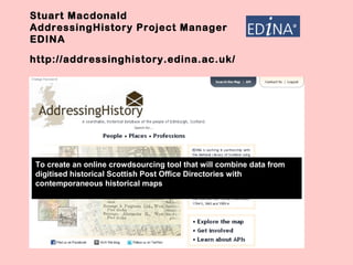
1. Stuart Macdonald
AddressingHistory Project Manager
EDINA
http://addressinghistory.edina.ac.uk/
To create an online crowdsourcing tool that will combine data from
digitised historical Scottish Post Office Directories with
contemporaneous historical maps
2. • Historic maps georeferenced by NLS
• PODs digitised by NLS with the Internet Archive
• Project focussed on 3 volumes of PODs: 1784-5; 1865; 1905-6
• Scalable to accommodate 400 Scottish PODs currently being digitised
• POD entries georeferenced by moving a pin on a digitised map thus
facilitating the addition of a grid reference to the OCR’d POD held in XML
database
• Mass geo-coding of PODs using Google geocoding services
• Mechanism to check user-generated content such as georeferences
• Amplification of tool and API via Social Media Channels
• Each POD entry will be accessible via the API through a unique URI -
opening up content to LOD cloud through RDF & Ontologies (geonames,
DBPedia)
CC image courtesy of Flickr –
http://www.flickr.com/photos/karenhorton/4477409137/
3. stuart.macdonald@ed.ac.uk
THANKING YOU!
Acknowledgements:
• JISC - http://www.jisc.ac.uk/
• National Library of Scotland - http://www.nls.uk/
• Visualising Urban Geographies (VUG)
project – http://geo.nls.uk/urbhist/
• Edinburgh City Libraries –
http://www.edinburgh.gov.uk/libraries/