Köppen Climate Classification Explained
•Download as PPTX, PDF•
0 likes•248 views

What is the difference between weather and climate? Koppen Classification is a tool that helps us recognize the many different climates in biomes worldwide.

Recommended
More Related Content
What's hot
What's hot (20)
Similar to Köppen Climate Classification Explained
Similar to Köppen Climate Classification Explained (20)
More from Kella Randolph
More from Kella Randolph (20)
Recently uploaded
Recently uploaded (20)
Köppen Climate Classification Explained
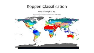
- 1. Koppen Classification Kella Randolph M. Ed. https://upload.wikimedia.org/wikipedia/commons/thumb/d/d5/K%C3%B6ppen-Geiger_Climate_Classification_Map.png/1200px-K%C3%B6ppen-Geiger_Climate_Classification_Map.png
- 2. Whose idea was this, anyhow? • Wladimir Köppen (1846–1940) was a German meteorologist and climatologist best known for his delineation and mapping of the climatic regions of the world. He played a major role in the advancement of climatology and meteorology for more than 70 years. Köppen’s achievements, practical and theoretical, profoundly influenced the development of atmospheric science. His greatest achievement came in 1900, when he introduced his mathematical system of climatic classification. Each of five major climate types was assigned a mathematical value according to temperature and rainfall. Since then, many of the systems introduced by other scholars have been based on Köppen’s work. • (text: https://www.britannica.com/science/Koppen- climate-classification) https://upload.wikimedia.org/wikipedia/commons/f/fa/Wladimir_Peter_K%C3%B6ppen.jpg
- 3. The Köppen classification subdivides terrestrial climates into five major types, represented by the capital letters A, B, C, D, and E. The midlatitude C and D climates are given a second letter, f (no dry season), w (winter dry), or s (summer dry), and a third symbol, a, b, c, or d (the last subclass exists only for D climates), indicating summer warmth or winter coldness. The H climate (highlands), which Köppen did not use, is sometimes added to other classifications to account for elevations above 1,500 metres (about 4,900 feet). (https://www.britannica.com/science/Koppen-climate-classification)
- 4. What is climate classification? • A climate classification is a tool used to recognize, clarify, and simplify the climatic similarities and differences between geographic areas in order to help us better understand Earth’s climates. Classification schemes rely on environmental data, such as temperature, rainfall, and snowfall, to uncover patterns and connections between climatic processes. ( text: https://www.britannica.com/science/Koppen-climate-classification) • Climate, conditions of the atmosphere at a particular location over a long period of time; it is the long-term summation of the atmospheric elements (and their variations) that, over short time periods, constitute weather. These elements are solar radiation, temperature, humidity, precipitation (type, frequency, and amount), atmospheric pressure, and wind (speed and direction). (text: https://www.britannica.com/science/climate-meteorology)
- 5. Climate classifications fall into two categories: genetic and empirical. • Genetic classifications group climates by their causes, focusing on how temperature relates to distance from the North Pole or South Pole or Equator, continentality versus ocean-influenced factors, the effects of mountains, or combinations of several factors. Genetic classifications are qualitative, and climatic regions are drawn in a subjective manner. • In contrast, empirical classifications—such as the Köppen climate classification—group each climate type according to one or more aspects of the climate system, such as natural vegetation. (text: https://www.britannica.com/science/Koppen-climate-classification)
- 6. Category Specific place on map __________. 1. What is the climate of this area? 2. Why does it fit into this specific category? 3. What types of plants and animals are there? 4. What is the average monthly temperature? 5. What is the average monthly precipitation?
- 7. Polar • Category Polar Specific place on map E areas. (Arctic, Antarctica and Greenland) • Polar climate: Cold winters and summers A polar climate consists of cool summers and very cold winters, which results in treeless tundra, glaciers, or a permanent or semi-permanent layer of ice. • Why does it fit into this specific category? A polar climate is a place where the climate usually has a temperature below freezing, is icy and is covered with snow most of the time. • What types of plants and animals are there? The Arctic consists of desert and tundra vegetations. The desert vegetation consists of algae, lichens, and mosses. Lichens are the most dominant plants. Antarctic hair grass and the Antarctic pearl wort. Every month in a polar climate has an average temperature of less than 10 °C (50 °F). Regions with polar climate cover more than 20% of the Earth's area. Polar region’s average monthly precipitation? Precitpitation.5 to .8 inches monthly or 6 to 10 inches yearly https://upload.wikimedia.org/wikipedia/commons/thumb/c/c6/Richard_F riese_Eisb%C3%A4renfamilie.jpg/1200px- Richard_Friese_Eisb%C3%A4renfamilie.jpg
- 8. Dry Class B (There are four minor classifications in the Dry classification. BW is a dry arid climate. BS is a dry, semi-arid climate. And for each of those classifications, there is an h and a k that are also used. H indicates this in the sub-tropics and k indicates this is in the middle latitudes. • (Arid and Semi-arid) Climates • Class B Climates are characterized by potential evaporation and transpiration exceeding precipitation. These climates are usually found in areas from 20 - 35° North and South of the equator and in large continental regions of the mid-latitudes often surrounded by mountains • Flora and fauna: cacti, spiny ocotillo, mesquite, armadillos, foxes, opossums, deer, snakes, lizards, desert owls, and pumas the temperatures for each month depending on the sun are: Days are very hot and nights are very cold. Highest Temperature: 86 °F Lowest Temperature: 36 °F • the average monthly precipitation? 0.6 inch
- 9. Temperate place on map C areas. 1. What is the climate of this area? Warm summers and mild winters 2. Why does it fit into this specific category? 3 minor classifications Cfa: Frequent thunderstorms in summer Cfb: Marine climates with large amounts of precipitation in winter Cs: Mediterranean climate zone • 3. What types of plants and animals are there? Plants include flowering dogwood, redbud, mountain laurel, bald cypress, southern magnolia, and black locust, all now cultivated in temperate regions worldwide, but also various food plants such as blueberries, black raspberries, cranberries, maple syrup and sugar, and pecans, and Monterey pine and other timber trees. North America has a diverse array of wildlife species and is home to an estimated 457 mammals (e.g. bison, raccoon, mountain lion, beaver, moose, and jaguar), 914 birds (e.g. Bald Eagle and Goose) 662 reptiles (e.g. alligator) more than 300 amphibians and 4,000 known arachnids (e.g bark scorpion). The North American territory includes the United States, Canada, Mexico, and Greenland, • 4. What is the average monthly temperature? ? Class C climates have an average monthly high temperature of 10 °C (50 °F) or more in the spring/summer months (April to September in northern hemisphere), and an average monthly low temperature greater than −3 °C (27 °F) in the fall/winter months. 5. What is the average monthly precipitation? 81 cm. https://www.telapost.com/wp- content/uploads/2014/03/app-state- 060720141.jpg
- 10. Tropical Specific place on map A areas. San Juan, Puerto Rico, also Southern Florida What is it like? This climate is dominated by the doldrums low-pressure system all year round, so has no natural seasons. Why does it fit into this specific category? High temperatures : year round average temperatures of 18 °C (64.4 °F) What types of plants and animals are there? Palms, alligators, snakes, bears, panthers, fish What is the average monthly temperature? Above 18 degrees Celsius /64.6 F What is the average monthly precipitation? Some areas have high amounts of precipitation. Year–round average precipitation of at least 60 mm (2.4 in). Three minor classifications Af: tropical wet climate Am: tropical monsoon climate Aw: tropical wet and dry climate https://cdn.pixabay.com/photo/2015/10/14/22/44/louisiana- 988654_640.jpg
- 11. Continental place on map D areas Regions of the Earth that have continental climates include Siberia and central Russia, and much of North America. Siberia, Canada and the northern states of the US • What is the climate of this area? They have mild- summers and cold winters • Why does it fit into this specific category? They have mild- summers and cold winters, and they have moderate levels of precipitation. • What types of plants and animals are there? • What is the average monthly temperature? These climates have an average temperature above 10 °C (50 °F) in their warmest months, and a coldest month average below −3 °C • What is the average monthly precipitation? they have moderate levels of precipitation. https://s.iha.com/00121673756/Russia-Siberian-landscape.jpeg