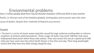
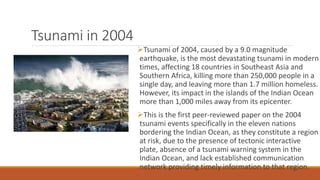
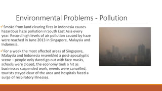
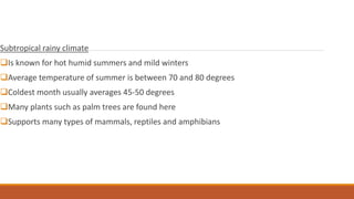
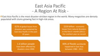
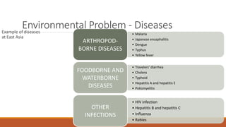
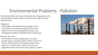
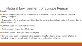
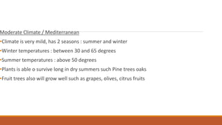
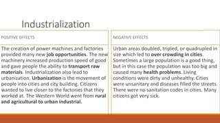
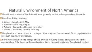
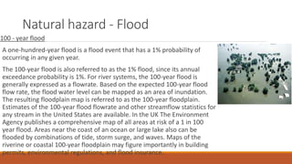
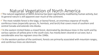
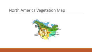
2. Natural Environment
The natural environment encompasses all living and non-living things occurring naturally,
meaning in this case not artificial. The term is most often applied to the Earth or some parts of
Earth. This environment encompasses the interaction of all living species, climate, weather, and
natural resources that affect human survival and economic activity. The concept of the natural
environment can be distinguished as components:
a) Complete ecological units that function as natural systems without massive civilized human
intervention, including all vegetation, microorganisms, soil, rocks, atmosphere, and natural
phenomena that occur within their boundaries and their nature
b) Universal natural resources and physical phenomena that lack clear-cut boundaries, such as
air, water, and climate, as well as energy, radiation, electric charge, and magnetism, not
originating from civilized human activity
3. Natural Environment of Southeast Asia
Region
Tropical Climate
Majority of country is geographically situated in the tropical latitudes
Have hot and rainy weather all year
Coolest temperature about 20-23 degree & may reach 30-33 degree celsius
Tropical rainforests only cover 6% oh the world's surface, yet they produce 40% of the oxygen & support nearly half
of all plant and animal species.
5. Envionmental problems
Over 2 million people died from natural disasters between 1970 and 2014 in Asia and the
Pacific, or 56.6 per cent of the fatalities globally. Earthquakes and tsunamis were the main
cause of deaths, despite their relatively infrequent occurrences.
Tsunami
Tsunami is a series of ocean waves typically caused by large undersea earthquakes or volcano
eruptions at tectonic plate boundaries. These surges of water may reach 100 feet and cause
widespread destruction when they crash ashore. They race across the sea at a speed up to 500
miles per hour and cross the entire Pacific Ocean in less than one day. Their long wavelength
means that they lose very little energy along the way.
6. Tsunami in 2004
Tsunami of 2004, caused by a 9.0 magnitude
earthquake, is the most devastating tsunami in modern
times, affecting 18 countries in Southeast Asia and
Southern Africa, killing more than 250,000 people in a
single day, and leaving more than 1.7 million homeless.
However, its impact in the islands of the Indian Ocean
more than 1,000 miles away from its epicenter.
This is the first peer-reviewed paper on the 2004
tsunami events specifically in the eleven nations
bordering the Indian Ocean, as they constitute a region
at risk, due to the presence of tectonic interactive
plate, absence of a tsunami warning system in the
Indian Ocean, and lack established communication
network providing timely information to that region.
7. Environmental Problems - Pollution
Smoke from land clearing fires in Indonesia causes
hazardous haze pollution in South East Asia every
year. Record high levels of air pollution caused by haze
were reached in June 2013 in Singapore, Malaysia and
Indonesia.
For a week the most affected areas of Singapore,
Malaysia and Indonesia resembled a post-apocalyptic
scene – people only dared go out with face masks,
schools were closed, the economy took a hit as
businesses suspended work, events were cancelled,
tourists stayed clear of the area and hospitals faced a
surge of respiratory illnesses.
8. Natural Environmental of East Asia
RegionContinental climate
Humid continental climate is one of the few climates with different season.
Warm and humid summer, cool and dry autumn, cold and harsh winter and a warm and wet
spring. Some area are covered in grassland.
Climate : excellent for farming since it has warm summers and regular rainfall
A wide variety of plants often supports a wide variety of animals including bears, wolves,
coyotes & deer
Animals who live in climate regions with a large range of temperature often migrate.
9. Subtropical rainy climate
Is known for hot humid summers and mild winters
Average temperature of summer is between 70 and 80 degrees
Coldest month usually averages 45-50 degrees
Many plants such as palm trees are found here
Supports many types of mammals, reptiles and amphibians
10. East Asia Pacific
- A Region At Risk -
East Asia Pacific is the most disaster-stricken region in the world. Many megacities are densely
populated with slums growing fast in high-risk areas.
61% of global losses from
disasters was sustained by
East Asia Pacific in the past
20 years
$259 billion - economic
losses from natural disasters
in the first 9 month (2011) -
the costliest year on record
1.6 billion people
have been affected by
disasters since 2000
40% of floods worldwide
happened in East Asia
between 1980 - 2011
11. Environmental Problem - DiseasesExample of diseases
at East Asia
• Malaria
• Japanese encephalitis
• Dengue
• Typhus
• Yellow fever
ARTHROPOD-
BORNE DISEASES
• Travelers' diarrhea
• Cholera
• Typhoid
• Hepatitis A and hepatitis E
• Poliomyelitis
FOODBORNE AND
WATERBORNE
DISEASES
• HIV infection
• Hepatitis B and hepatitis C
• Influenza
• Rabies
OTHER
INFECTIONS
12. Environmental Problems - Pollution
Thermal pollution is the act of altering the temperature of a
natural body of water, which may be a river, lake or ocean
environment.
Migration
- Bad oxygen and temperature changes in the
environment will prompt organisms to move
away from the area and populate news area,
changing ecosystems & biodiversity in both area
Shorter Plant Life
- An increase in water temperature increase
growth rates of aquatic plants, which results in a
shorter life for plants & overpopulation of the
species. A rush of warm water can cause an
algae bloom that will reduce the oxygen in water
13. Natural Environment of Europe Region
Oceanic
Oceanic temperature climate also known as Marine West Coast is located from Southern
Norway and Spain.
Temperature : fairly small compared to other climate type ( don't have major differences during
different seasons )
Only has 2 seasons : summer and winter
Coldest month : lower than 30 degrees
Warmest month : averages about 72 degrees
Climate areas receive regular rain that supports thick forests and a wide variety of plant life
including evergreen trees (conifers) suh as spruce, cedar, pine, redwood.
14. Moderate Climate / Mediterranean
•Climate is very mild, has 2 seasons : summer and winter
•Winter temperatures : between 30 and 65 degrees
•Summer temperatures : above 50 degrees
•Plants is able o survive long in dry summers such Pine trees oaks
•Fruit trees also will grow well such as grapes, olives, citrus fruits
15. Industrialization
POSITIVE EFFECTS
The creation of power machines and factories
provided many new job opportunities. The new
machinery increased production speed of good
and gave people the ability to transport raw
materials. Industrialization also lead to
urbanization. Urbanization is the movement of
people into cities and city building. Citizens
wanted to live closer to the factories that they
worked at. The Western World went from rural
and agricultural to urban industrial.
NEGATIVE EFFECTS
Urban areas doubled, tripled, or quadrupled in
size which led to over crowding in cities.
Sometimes a large population is a good thing,
but in this case the population was too big and
caused many health problems. Living
conditions were dirty and unhealthy. Cities
were unsanitary and diseases filled the streets.
There were no sanitation codes in cities. Many
citizens got very sick.
16. Natural Environment of North America
Climatic environment of North America are generally similar to Europe and northern Asia.
Have four distinct seasons:
> Spring - March, April, May
> Summer - June, July, August
> Autumn - September, October, November
> Winter - December, January, February
The plant life is characterised according to climatic region. The coniferous forest region contains
trees such as pine, fir and spruce.
North America is home to a range of wild animals including the sea otter, raccoon and the
mountain lion. Polar bears, wolves and caribou live in the arctic regions of Canada & Greenland
17. Natural hazard - Flood
100 - year flood
A one-hundred-year flood is a flood event that has a 1% probability of
occurring in any given year.
The 100-year flood is also referred to as the 1% flood, since its annual
exceedance probability is 1%. For river systems, the 100-year flood is
generally expressed as a flowrate. Based on the expected 100-year flood
flow rate, the flood water level can be mapped as an area of inundation.
The resulting floodplain map is referred to as the 100-year floodplain.
Estimates of the 100-year flood flowrate and other streamflow statistics for
any stream in the United States are available. In the UK The Environment
Agency publishes a comprehensive map of all areas at risk of a 1 in 100
year flood. Areas near the coast of an ocean or large lake also can be
flooded by combinations of tide, storm surge, and waves. Maps of the
riverine or coastal 100-year floodplain may figure importantly in building
permits, environmental regulations, and flood insurance.
18. Natural Vegetation of North AmericaThe natural vegetation of North America has been significantly modified by human activity, but
its general nature is still apparent over much of the continent.
The most notable forest is the taiga, or boreal forest, an enormous expanse of mostly
coniferous trees (especially spruce, fir, hemlock, and larch) that covers most of southern and
central Canada and extends into Alaska.
In the eastern United States a mixed forest, dominated by deciduous trees in the north and by
various species of yellow pine in the south-east, has mostly been cleared or cut over, but a
considerable area has regrown since the 1940s.
In the western portion of the continent, forests are primarily associated with mountain ranges,
and coniferous trees are dominant.