
Recommended
Recommended
More Related Content
What's hot
What's hot (16)
Similar to Iroquois National Wildlife Refuge and Surrounding Areas
Similar to Iroquois National Wildlife Refuge and Surrounding Areas (20)
More from Heritage Wind
More from Heritage Wind (20)
Recently uploaded
Recently uploaded (20)
Iroquois National Wildlife Refuge and Surrounding Areas
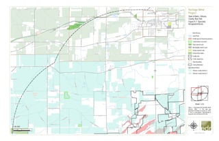
- 1. !!!!!! ! ! ! ! ! ! ! ! ! ! ! ! ! ! ! ! ! ! ! ! ! ! ! ! ! ! ! ! ! ! ! ! ! ! ! ! ! ! ! ! ! ! ! ! ! ! ! ! ! ! ! ! ! ! ! ! ! ! ! ! ! ! ! ! ! ! ! ! ! ! ! ! ! ! ! ! ! Iroquois National Wildlife Refuge Town of Albion Town of Barre Town of Gaines Town of Ridgeway Town of Shelby Albion Reservoir NO 1 Albion Reservoir NO 2 Erie Canal Pond Lake Otter Pond LibertySt AcademySt PlattSt Portage Rd CR 44A Barre Rd Albion Eagle Harbor Rd HillRd BrownRd Locust Ln CR 74 IngersollSt ClarendonSt BrownSt Munzel Rd Moore St CR 2 Sanderson R d ClintonSt GainesBasinRd Park St KenyonvilleRd Trensch Rd Densmore StBeechwood Blvd CR88 SnellRd Wheeler Rd Barber Rd DresserRd Shelby West Barre Rd Linwood Ave KamsRd Caroline St Root Rd Harrison Rd WoodRd CR10 Lime Kiln Rd CR4 Scott Rd ButtsRd Posson R d G illette Rd ClarendonRd Holley Rd Miller Rd CR 56 SouthwoodsRd BurnsRd CR20 AllensBridgeRd MixRd Cushing Rd BraggSchoolhouseRd Puzzey Rd WilkinsRd CR 45A Porter Rd BealsRd Phipps Rd JohnnyCakeLn CR 45C Maple St CraneRd Allis Rd BigfordRd Delano Steele Rd County House Rd Pask Rd Presbyterian Rd CR99 Martin Rd Fletcher Chapel Rd LongBridgeRd CR 79 Hemlock Ridge Rd TownlineRd CR 36B CR30 State St CR25 Bank St HamiltonSt CR21 CR 69 Gray Rd Washington St CR35 CR 25B Allen Rd CR18 CR45 Telegraph Rd PineHillRd CulvertRd CR8CR28 CR5 CR45B CR 98 UV98 UV31 UV31A Albion 0 0.5 10.25 Miles www.edrdpc.com µ Notes: 1. Basemap:ESRI StreetMap North America, 2008.. 2. This map was generated in ArcMap on January 24, 2020. 3. This is a color graphic. Reproduction in grayscale may misrepresent the data. Heritage Wind Project Town of Barre, Orleans County, New York Figure 4-7: Specially Designated Areas ! !! ! ! ! ! !! ! ! ! ! ! ! ! ! ! ! 1:50,000 Sheet 1 of 4 River/Stream Lake/Pond FEMA Special Flood Hazard Area Conservation Easement State-owned Land Municipality-owned Land Private-owned Land Federal Recreation Facility Site ! ! ! ! 5-mile Study Area Town Boundary County Boundary Agricultural District: Orleans County District 2 Orleans County District 3
- 2. ! ! ! ! ! ! ! ! ! ! ! ! ! ! ! ! ! ! ! ! ! ! !!!!!!!!!!!!!!! ! ! ! ! ! ! ! ! ! ! ! ! ! ! ! ! ! ! ! ! ! ! ! ! ! ! ! ! ! ! ! ! ! ! ! ! ! ! ! ! ! ! ! ! ! ! ! ! ! ! ! ! ! ! ! ! ! ! ! ! ! ! ! ! ! ! ! ! ! ! ! Town of Albion Town of Barre Town of Clarendon Town of Gaines Town of Murray MC Cargo Lake Erie Lake Pond Marsh Creek LibertySt CR 74 AcademySt PlattSt ManningRd Union St CR 77 ParkPl Barre Rd East Ave HighSt CR 17 RockRd Locust Ln IngersollSt ClarendonSt CR30A BrownSt Moore St CR 2 ClintonSt GainesBasinRd Park St CenterRd HibbardRd CR88 CR91 CR12 TransitRd Densmore St Jackson Rd Geddes St Beechwood Blvd Taylor Rd MerrillRd C R 33 Bacon Rd Linwood Ave TuthillRd Caroline St Skillington Rd MathesRd Thorpe Rd Hinds Rd Lime Kiln Rd Powerline Rd KendallRd ButtsRd Mansfield Rd BraggSchoolhouseRd CR 54 Lynch Rd Cushing Rd CR34 CR 99 Phillips Rd ClarendonRd CR 56 KeitelRd AngevineRd CartonRd CR22 Brockville Rd CR 3 Canal Rd HindsburgRd LattinRd Maple St Holley Rd NorwayRd LakeRd CR47 CR24HulbertonRd CR59 CR 76 Transit Church Rd CR96 Creek Rd CR44A CR40 CrandallRd GrothRd BrownRd Brown Schoolhouse Rd CR83 County House Rd CR64 CR11 CulverRd BennettsCornersRd Allen Rd CR 36B State St Bank St HamiltonSt CR 98 Washington St CR 25B CR 69 UV31 UV237 UV279 UV104 UV31A UV387 UV98 Albion Holley 0 0.5 10.25 Miles www.edrdpc.com µ Notes: 1. Basemap:ESRI StreetMap North America, 2008.. 2. This map was generated in ArcMap on January 24, 2020. 3. This is a color graphic. Reproduction in grayscale may misrepresent the data. Heritage Wind Project Town of Barre, Orleans County, New York Figure 4-7: Specially Designated Areas ! !! ! ! ! ! !! ! ! ! ! ! ! ! ! ! ! 1:50,000 Sheet 2 of 4 River/Stream Lake/Pond FEMA Special Flood Hazard Area Conservation Easement State-owned Land Municipality-owned Land Private-owned Land Facility Site ! ! ! ! 5-mile Study Area Town Boundary County Boundary Agricultural District: Orleans County District 1 Orleans County District 2 Orleans County District 3
- 3. ! ! ! ! ! ! ! ! ! ! ! ! ! ! ! !!!!! ! ! ! ! ! ! ! ! ! ! ! ! ! ! ! !!!!!!!!!!!!!!!! ! ! ! ! ! ! ! ! ! ! ! ! ! ! ! ! ! ! ! ! ! ! ! ! ! ! ! ! ! ! ! ! ! ! ! ! ! ! ! ! ! ! !!!!!!!!!!!!! ! ! ! ! ! ! ! ! ! Oak Orchard State Wildlife Management Area Iroquois National Wildlife Refuge Genesee County Orleans County Town of Alabama Town of Barre Town of Elba Town of Oakfield Town of Shelby Lake Oak Orchard Creek Pond Watson Rd PearlSt MorganRd Mill St O ak St Coe Ave Ford Rd Towne Pl Ridge Rd Spoil Bank Rd Chapel St WightRd Church St BigfordRd ParkAve Muck Rd Drake Island Road Ext MapleStreetRd CR30 PearlRd HuttonRd DrakeIslandRd Trensch Rd HillRd CR 39A Smith Rd Barber Rd Johnson Rd GortonRd Root Rd Pekin Rd OakOrchardRd West Ave GrahamRd BlissRd Posson Rd FoxRd CR 16 Tibbits Rd Bridge Rd SnyderRd WeatherwaxRd CR 7 Maple Ave MacumberRd Maltby Rd CR 22 Puzzey Rd Ham Rd Roberts Rd SouthwoodsRd Allis Rd Edgerton Rd G illette Rd Delano Steele Rd Lewiston Rd CR99 Fletcher Chapel Rd TownlineRd CraneRd BurnsRd Hemlock Ridge Rd CR9 PineHillRd CR25 Gray Rd C R 15 CR5 CR 98 C R 24 CR28 FisherRd CR 23 CR 12 UV262 UV63 UV98 Elba Oakfield 0 0.5 10.25 Miles www.edrdpc.com µ Notes: 1. Basemap:ESRI StreetMap North America, 2008.. 2. This map was generated in ArcMap on January 24, 2020. 3. This is a color graphic. Reproduction in grayscale may misrepresent the data. Heritage Wind Project Town of Barre, Orleans County, New York Figure 4-7: Specially Designated Areas ! !! ! ! ! ! !! ! ! ! ! ! ! ! ! ! ! 1:50,000 Sheet 3 of 4 River/Stream Lake/Pond FEMA Special Flood Hazard Area Conservation Easement State-owned Land Municipality-owned Land State Recreation Federal Recreation Facility Site ! ! ! ! 5-mile Study Area Town Boundary County Boundary Agricultural District: Orleans County District 2 Genesee County District 2 Genesee County District 12
- 4. ! ! ! ! ! ! ! ! ! ! ! ! ! ! ! ! ! ! ! ! ! ! ! ! ! ! ! ! ! ! ! ! ! ! ! ! ! ! ! ! ! ! ! ! ! ! ! ! ! ! ! ! ! ! ! ! ! ! ! ! ! ! ! ! ! ! ! ! ! ! ! !!!!! ! ! ! ! ! ! ! ! ! ! ! ! ! ! ! !!!!!! Genesee County Orleans County Town of Barre Town of Byron Town of Clarendon Town of Elba Pond Watson Rd HessenthalerRd CaswellRd CR19A Ridge Rd CR13 Barre Rd Ford Rd Ladue Rd NortonRd Chapel StChurch St ManningRd Muck Rd Spoil Bank Rd Drake Island Road Ext Allis Rd TownLineRd Mill Pond Rd MudCityRd Boots Rd Swamp Rd MillerRd DrakeIslandRd UpperHolleyRd Munger Rd CR 16 CR41 Root Rd BirdRd CushingRd BraggSchoolhouseRd Glidden Rd CR59 StroutsRd FairgroundRd New Guinea Rd IvisonRd TrippRd MerrimanRd OakOrchardRd West Ave GrahamRd ChuggRd Mcnamar Rd Cole Rd LogCityRd SnyderRd ArnoldRd WeatherwaxRd Hundredmark Rd Chapel Rd Cockram Rd Puzzey Rd CR 14 CulverRd CR 99 Cook Rd G illette Rd Shelt Rd Sheelar Rd Delano Steele Rd AngevineRd TransitRd CR73 SearlsRd CR96 Brown Schoolhouse Rd Tower Hill Rd CR42 Bridge Rd MerrillRd CR 7 CR 12 C R 24 C R 98 UV237 UV262 UV98 Elba 0 0.5 10.25 Miles www.edrdpc.com µ Notes: 1. Basemap:ESRI StreetMap North America, 2008.. 2. This map was generated in ArcMap on January 24, 2020. 3. This is a color graphic. Reproduction in grayscale may misrepresent the data. Heritage Wind Project Town of Barre, Orleans County, New York Figure 4-7: Specially Designated Areas ! !! ! ! ! ! !! ! ! ! ! ! ! ! ! ! ! 1:50,000 Sheet 4 of 4 River/Stream Lake/Pond FEMA Special Flood Hazard Area Conservation Easement Municipality-owned Land Facility Site ! ! ! ! 5-mile Study Area Town Boundary County Boundary Agricultural District: Orleans County District 2 Genesee County District 2 Genesee County District 5 Genesee County District 12