SlideShare a Scribd company logo
1 of 62
Download to read offline
#*
#*
&=!
&=!
&=!
&=!
&=!
&=!
&=!
&=!
&=!
&=!
&=!
&=!
&=!
&=!
&=!
&=!
&=!
&=!
&=!
&=!
&=!
&=!
&=!
&=!
&=!
&=!
&=!
&=!
&=!
&=!
&=!
&=!
&=!
1 2
3 4
5 6
7 8 9 10
11 12 13 14
15
16 17 18 19
20 21
22 23 24 25 26 27 28
29
30 31 32 33
34
35 36 37 38 39
40 41
42 43 44
45
46 47 48
49 50 51 52 53 54 55 56
57 58
59 60 61 62 63 64 65 66
67 68
69 70 71 72 73 74 75 76
77
78
79 80 81 82 83 84 85 86
87
88 89
90 91 92 93 94
95 96 97 98 99 100 101
102 103
104
105
106 107 108 109
110
111
112 113
114 115
116 117
118
119
120
121 122 123
www.edrdpc.com
µ
Notes: 1. Basemap: ESRI ArcGIS Online
"USGS Topo Map" map service. 2. This
map was generated in ArcMap on
February 12, 2020. 3. This is a color
graphic. Reproduction in grayscale may
misrepresent the data.
Heritage Wind
Project
Town of Barre, Orleans
County, New York
Figure 22-1: Impact to
Plant Communities
&=!
Wind Turbine
#* Permanent Met Tower
Access Road
Collection Line
POI Substation
Collection Substation
O&M Facility
Laydown Area and Batch Plant
Limit of Clearing
Facility Site
0 2,000 4,0001,000
Feet
&=!
!(
!(!(
!(
!(
!(!(
!(
!(
!(
!(
!(
!(
!(
!(
!(
!(
!(
!(
!(
!(
!(
!(
ROMUARVU ROMU
LOMO
ARVU
LOMO
RHCA
ROMU
ROMU
RHCA
RHCA
T29
www.edrdpc.com
µ
Notes: 1. Basemap: NYSDOP "2015"
orthoimagery map service. 2. This map
was generated in ArcMap on February 12,
2020. 3. This is a color graphic.
Reproduction in grayscale may
misrepresent the data.
Heritage Wind
Project
Town of Barre, Orleans
County, New York
Figure 22-1: Impact to
Plant Communities
!( Invasive Species
&=!
Wind Turbine
Collection Line
Access Road
Limit of Clearing
Facility Site
Vegetative Community:
Silver Maple-Ash Swamp
Sheet 1 of 123
1:2,000
0 100 20050
Feet
&=!
!(
!(
!(!(
!(
!(
ALPE
ROMU
ALPEALPE
www.edrdpc.com
µ
Notes: 1. Basemap: NYSDOP "2015"
orthoimagery map service. 2. This map
was generated in ArcMap on February 12,
2020. 3. This is a color graphic.
Reproduction in grayscale may
misrepresent the data.
Heritage Wind
Project
Town of Barre, Orleans
County, New York
Figure 22-1: Impact to
Plant Communities
!( Invasive Species
Access Road
Limit of Clearing
Facility Site
Vegetative Community:
Silver Maple-Ash Swamp
Sheet 2 of 123
1:2,000
0 100 20050
Feet
&=!
!(
!(!(
!(
!(
!(!(
!(
!(
!(
!(
!(
!(
!(
!(
!(
!(
!(
!(
!(
!(
!(
!(
!(
!(
!(
!(
!(
!(
!(
SWALLOWWORT
RHCA
PHAU
VINCETOXICUM
SPP
VINCETOXICUM
SPP
ARVU
ARVU
ARVU
RHCA
LOMO
RHCAARVU
LOMO
ROMU
ARVU
RHCA
ARVU
ARVU
ARVU
RHCA
T30
www.edrdpc.com
µ
Notes: 1. Basemap: NYSDOP "2015"
orthoimagery map service. 2. This map
was generated in ArcMap on February 12,
2020. 3. This is a color graphic.
Reproduction in grayscale may
misrepresent the data.
Heritage Wind
Project
Town of Barre, Orleans
County, New York
Figure 22-1: Impact to
Plant Communities
!( Invasive Species
&=!
Wind Turbine
Collection Line
Access Road
Limit of Clearing
Facility Site
Vegetative Community:
Silver Maple-Ash Swamp
Sheet 3 of 123
1:2,000
0 100 20050
Feet
&=!
!(
!(
!(
!(
!(!(
!(
!(
ARVU
LOMO
ROMU
VINCETOXICUM
SPP
T33
www.edrdpc.com
µ
Notes: 1. Basemap: NYSDOP "2015"
orthoimagery map service. 2. This map
was generated in ArcMap on February 12,
2020. 3. This is a color graphic.
Reproduction in grayscale may
misrepresent the data.
Heritage Wind
Project
Town of Barre, Orleans
County, New York
Figure 22-1: Impact to
Plant Communities
!( Invasive Species
&=!
Wind Turbine
Collection Line
Access Road
Limit of Clearing
Facility Site
Vegetative Community:
Successional Shrubland
Silver Maple-Ash Swamp
Sheet 4 of 123
1:2,000
0 100 20050
Feet
!(
!(
!(
!(
!(
!(
!(
!(
!(
!(
!(
!(
!(
!(
!(
CIAR
LOMO
CIAR
LOMO ALPE
CIAR
ROPS
CIAR
RHCA
ROPS
LOMO
www.edrdpc.com
µ
Notes: 1. Basemap: NYSDOP "2015"
orthoimagery map service. 2. This map
was generated in ArcMap on February 12,
2020. 3. This is a color graphic.
Reproduction in grayscale may
misrepresent the data.
Heritage Wind
Project
Town of Barre, Orleans
County, New York
Figure 22-1: Impact to
Plant Communities
!( Invasive Species
Collection Line
Access Road
Limit of Clearing
Facility Site
Vegetative Community:
Disturbed/Developed
Sheet 5 of 123
1:2,000
0 100 20050
Feet
&=!
!(
!(
!(
!(
!( !(
!(
UV31A
CIAR
LOMO
CIAR CIAR
T32
www.edrdpc.com
µ
Notes: 1. Basemap: NYSDOP "2015"
orthoimagery map service. 2. This map
was generated in ArcMap on February 12,
2020. 3. This is a color graphic.
Reproduction in grayscale may
misrepresent the data.
Heritage Wind
Project
Town of Barre, Orleans
County, New York
Figure 22-1: Impact to
Plant Communities
!( Invasive Species
&=!
Wind Turbine
Collection Line
Access Road
Limit of Clearing
Facility Site
Vegetative Community:
Disturbed/Developed
Successional Shrubland
Sheet 6 of 123
1:2,000
0 100 20050
Feet
Thorpe Rd
www.edrdpc.com
µ
Notes: 1. Basemap: NYSDOP "2015"
orthoimagery map service. 2. This map
was generated in ArcMap on February 12,
2020. 3. This is a color graphic.
Reproduction in grayscale may
misrepresent the data.
Heritage Wind
Project
Town of Barre, Orleans
County, New York
Figure 22-1: Impact to
Plant Communities
Facility Site
Vegetative Community:
Silver Maple-Ash Swamp
Sheet 7 of 123
1:2,000
0 100 20050
Feet
CR 36A
MathesRd
Thorpe
Rd
UV31A
www.edrdpc.com
µ
Notes: 1. Basemap: NYSDOP "2015"
orthoimagery map service. 2. This map
was generated in ArcMap on February 12,
2020. 3. This is a color graphic.
Reproduction in grayscale may
misrepresent the data.
Heritage Wind
Project
Town of Barre, Orleans
County, New York
Figure 22-1: Impact to
Plant Communities
Facility Site
Vegetative Community:
Disturbed/Developed
Hayfield/Pasture
Successional Southern Hardwoods
Sheet 8 of 123
1:2,000
0 100 20050
Feet
!(
!(
!(
!(
!(
!(
!(
!(!(
!(
!(
!(
!(
!(
!(
CR69
UV31A
ALPE LOMO
ROPS LOMO
ALPE
RHCA
ROMU www.edrdpc.com
µ
Notes: 1. Basemap: NYSDOP "2015"
orthoimagery map service. 2. This map
was generated in ArcMap on February 12,
2020. 3. This is a color graphic.
Reproduction in grayscale may
misrepresent the data.
Heritage Wind
Project
Town of Barre, Orleans
County, New York
Figure 22-1: Impact to
Plant Communities
!( Invasive Species
Limit of Clearing
Facility Site
Vegetative Community:
Disturbed/Developed
Hayfield/Pasture
Successional Old Field
Successional Shrubland
Successional Southern Hardwoods
Pine Plantation
Sheet 9 of 123
1:2,000
0 100 20050
Feet
&=!
!(
!(
!(
!(
!(
!(
!(
!(
UV31A
CIAR
LOMO
ACPL
ROPS
T31
www.edrdpc.com
µ
Notes: 1. Basemap: NYSDOP "2015"
orthoimagery map service. 2. This map
was generated in ArcMap on February 12,
2020. 3. This is a color graphic.
Reproduction in grayscale may
misrepresent the data.
Heritage Wind
Project
Town of Barre, Orleans
County, New York
Figure 22-1: Impact to
Plant Communities
!( Invasive Species
&=!
Wind Turbine
Collection Line
Access Road
Limit of Clearing
Facility Site
Vegetative Community:
Disturbed/Developed
Successional Shrubland
Successional Southern Hardwoods
Sheet 10 of 123
1:2,000
0 100 20050
Feet
Thorpe Rd
CulverRd
www.edrdpc.com
µ
Notes: 1. Basemap: NYSDOP "2015"
orthoimagery map service. 2. This map
was generated in ArcMap on February 12,
2020. 3. This is a color graphic.
Reproduction in grayscale may
misrepresent the data.
Heritage Wind
Project
Town of Barre, Orleans
County, New York
Figure 22-1: Impact to
Plant Communities
Facility Site
Vegetative Community:
Disturbed/Developed
Sheet 11 of 123
1:2,000
0 100 20050
Feet
#*
&=!
Thorpe Rd
MET-2
T28
www.edrdpc.com
µ
Notes: 1. Basemap: NYSDOP "2015"
orthoimagery map service. 2. This map
was generated in ArcMap on February 12,
2020. 3. This is a color graphic.
Reproduction in grayscale may
misrepresent the data.
Heritage Wind
Project
Town of Barre, Orleans
County, New York
Figure 22-1: Impact to
Plant Communities
&=!
Wind Turbine
#* Permanent Met Tower
Collection Line
Access Road
Facility Site
Vegetative Community:
Disturbed/Developed
Sheet 12 of 123
1:2,000
0 100 20050
Feet
&=!
MathesRd
www.edrdpc.com
µ
Notes: 1. Basemap: NYSDOP "2015"
orthoimagery map service. 2. This map
was generated in ArcMap on February 12,
2020. 3. This is a color graphic.
Reproduction in grayscale may
misrepresent the data.
Heritage Wind
Project
Town of Barre, Orleans
County, New York
Figure 22-1: Impact to
Plant Communities
Collection Line
Access Road
Facility Site
Vegetative Community:
Disturbed/Developed
Hayfield/Pasture
Open Water
Sheet 13 of 123
1:2,000
0 100 20050
Feet
!( !(
!(
!(
!(
!(
!(
!(
!(!(
!(
!(
!(
CR69 LOMO
LOMO
CEOR
CEOR
ARVU
ROMU
ROMU
ROMU
ROMUROMU
ELUM
www.edrdpc.com
µ
Notes: 1. Basemap: NYSDOP "2015"
orthoimagery map service. 2. This map
was generated in ArcMap on February 12,
2020. 3. This is a color graphic.
Reproduction in grayscale may
misrepresent the data.
Heritage Wind
Project
Town of Barre, Orleans
County, New York
Figure 22-1: Impact to
Plant Communities
!( Invasive Species
Collection Line
Access Road
Limit of Clearing
Facility Site
Vegetative Community:
Disturbed/Developed
Hayfield/Pasture
Successional Shrubland
Successional Southern Hardwoods
Sheet 14 of 123
1:2,000
0 100 20050
Feet
&=!
!(
!(
!(
www.edrdpc.com
µ
Notes: 1. Basemap: NYSDOP "2015"
orthoimagery map service. 2. This map
was generated in ArcMap on February 12,
2020. 3. This is a color graphic.
Reproduction in grayscale may
misrepresent the data.
Heritage Wind
Project
Town of Barre, Orleans
County, New York
Figure 22-1: Impact to
Plant Communities
Collection Line
Access Road
Limit of Clearing
Facility Site
Vegetative Community:
Successional Shrubland
Successional Southern Hardwoods
Sheet 15 of 123
1:2,000
0 100 20050
Feet
LimeKilnRd
CR 69
www.edrdpc.com
µ
Notes: 1. Basemap: NYSDOP "2015"
orthoimagery map service. 2. This map
was generated in ArcMap on February 12,
2020. 3. This is a color graphic.
Reproduction in grayscale may
misrepresent the data.
Heritage Wind
Project
Town of Barre, Orleans
County, New York
Figure 22-1: Impact to
Plant Communities
Facility Site
Sheet 16 of 123
1:2,000
0 100 20050
Feet
www.edrdpc.com
µ
Notes: 1. Basemap: NYSDOP "2015"
orthoimagery map service. 2. This map
was generated in ArcMap on February 12,
2020. 3. This is a color graphic.
Reproduction in grayscale may
misrepresent the data.
Heritage Wind
Project
Town of Barre, Orleans
County, New York
Figure 22-1: Impact to
Plant Communities
Facility Site
Vegetative Community:
Disturbed/Developed
Sheet 17 of 123
1:2,000
0 100 20050
Feet
!(
!(
LOMO
LOMO
www.edrdpc.com
µ
Notes: 1. Basemap: NYSDOP "2015"
orthoimagery map service. 2. This map
was generated in ArcMap on February 12,
2020. 3. This is a color graphic.
Reproduction in grayscale may
misrepresent the data.
Heritage Wind
Project
Town of Barre, Orleans
County, New York
Figure 22-1: Impact to
Plant Communities
!( Invasive Species
Collection Line
Facility Site
Vegetative Community:
Disturbed/Developed
Sheet 18 of 123
1:2,000
0 100 20050
Feet
www.edrdpc.com
µ
Notes: 1. Basemap: NYSDOP "2015"
orthoimagery map service. 2. This map
was generated in ArcMap on February 12,
2020. 3. This is a color graphic.
Reproduction in grayscale may
misrepresent the data.
Heritage Wind
Project
Town of Barre, Orleans
County, New York
Figure 22-1: Impact to
Plant Communities
Facility Site
Sheet 19 of 123
1:2,000
0 100 20050
Feet
www.edrdpc.com
µ
Notes: 1. Basemap: NYSDOP "2015"
orthoimagery map service. 2. This map
was generated in ArcMap on February 12,
2020. 3. This is a color graphic.
Reproduction in grayscale may
misrepresent the data.
Heritage Wind
Project
Town of Barre, Orleans
County, New York
Figure 22-1: Impact to
Plant Communities
Facility Site
Sheet 20 of 123
1:2,000
0 100 20050
Feet
!(
!(
!(
!( !(
!(
!(
!(
!(
!(
!( !(
CEST
ELUM
CIAR
CEST
LOMO RHCA
ELUM
ROMU
ELUM
CIAR
CIAR
CIAR LOMO
www.edrdpc.com
µ
Notes: 1. Basemap: NYSDOP "2015"
orthoimagery map service. 2. This map
was generated in ArcMap on February 12,
2020. 3. This is a color graphic.
Reproduction in grayscale may
misrepresent the data.
Heritage Wind
Project
Town of Barre, Orleans
County, New York
Figure 22-1: Impact to
Plant Communities
!( Invasive Species
Access Road
Limit of Clearing
Facility Site
Vegetative Community:
Disturbed/Developed
Successional Shrubland
Silver Maple-Ash Swamp
Sheet 21 of 123
1:2,000
0 100 20050
Feet
&=!
!(
!( !(
!(
!(
!(
CIAR
CIAR CIAR
T11
www.edrdpc.com
µ
Notes: 1. Basemap: NYSDOP "2015"
orthoimagery map service. 2. This map
was generated in ArcMap on February 12,
2020. 3. This is a color graphic.
Reproduction in grayscale may
misrepresent the data.
Heritage Wind
Project
Town of Barre, Orleans
County, New York
Figure 22-1: Impact to
Plant Communities
!( Invasive Species
&=!
Wind Turbine
Collection Line
Access Road
Limit of Clearing
Facility Site
Vegetative Community:
Successional Shrubland
Silver Maple-Ash Swamp
Sheet 22 of 123
1:2,000
0 100 20050
Feet
!(
!(
!(
!(
!(
!(
ALPE
PHAU
BETH, ROMU
ACPL
ROMU
ALPE
www.edrdpc.com
µ
Notes: 1. Basemap: NYSDOP "2015"
orthoimagery map service. 2. This map
was generated in ArcMap on February 12,
2020. 3. This is a color graphic.
Reproduction in grayscale may
misrepresent the data.
Heritage Wind
Project
Town of Barre, Orleans
County, New York
Figure 22-1: Impact to
Plant Communities
!( Invasive Species
Collection Line
Access Road
Laydown Area and Batch Plant
Limit of Clearing
Facility Site
Vegetative Community:
Disturbed/Developed
Silver Maple-Ash Swamp
Sheet 23 of 123
1:2,000
0 100 20050
Feet
www.edrdpc.com
µ
Notes: 1. Basemap: NYSDOP "2015"
orthoimagery map service. 2. This map
was generated in ArcMap on February 12,
2020. 3. This is a color graphic.
Reproduction in grayscale may
misrepresent the data.
Heritage Wind
Project
Town of Barre, Orleans
County, New York
Figure 22-1: Impact to
Plant Communities
Facility Site
Vegetative Community:
Disturbed/Developed
Sheet 24 of 123
1:2,000
0 100 20050
Feet
www.edrdpc.com
µ
Notes: 1. Basemap: NYSDOP "2015"
orthoimagery map service. 2. This map
was generated in ArcMap on February 12,
2020. 3. This is a color graphic.
Reproduction in grayscale may
misrepresent the data.
Heritage Wind
Project
Town of Barre, Orleans
County, New York
Figure 22-1: Impact to
Plant Communities
Facility Site
Sheet 25 of 123
1:2,000
0 100 20050
Feet
www.edrdpc.com
µ
Notes: 1. Basemap: NYSDOP "2015"
orthoimagery map service. 2. This map
was generated in ArcMap on February 12,
2020. 3. This is a color graphic.
Reproduction in grayscale may
misrepresent the data.
Heritage Wind
Project
Town of Barre, Orleans
County, New York
Figure 22-1: Impact to
Plant Communities
Facility Site
Sheet 26 of 123
1:2,000
0 100 20050
Feet
www.edrdpc.com
µ
Notes: 1. Basemap: NYSDOP "2015"
orthoimagery map service. 2. This map
was generated in ArcMap on February 12,
2020. 3. This is a color graphic.
Reproduction in grayscale may
misrepresent the data.
Heritage Wind
Project
Town of Barre, Orleans
County, New York
Figure 22-1: Impact to
Plant Communities
Facility Site
Sheet 27 of 123
1:2,000
0 100 20050
Feet
&=!
!(
!(
!(
CIAR
LOMO
T22
www.edrdpc.com
µ
Notes: 1. Basemap: NYSDOP "2015"
orthoimagery map service. 2. This map
was generated in ArcMap on February 12,
2020. 3. This is a color graphic.
Reproduction in grayscale may
misrepresent the data.
Heritage Wind
Project
Town of Barre, Orleans
County, New York
Figure 22-1: Impact to
Plant Communities
!( Invasive Species
&=!
Wind Turbine
Collection Line
Access Road
Facility Site
Sheet 28 of 123
1:2,000
0 100 20050
Feet
&=!
T24
www.edrdpc.com
µ
Notes: 1. Basemap: NYSDOP "2015"
orthoimagery map service. 2. This map
was generated in ArcMap on February 12,
2020. 3. This is a color graphic.
Reproduction in grayscale may
misrepresent the data.
Heritage Wind
Project
Town of Barre, Orleans
County, New York
Figure 22-1: Impact to
Plant Communities
&=!
Wind Turbine
Collection Line
Access Road
Facility Site
Sheet 29 of 123
1:2,000
0 100 20050
Feet
#*
!(
!(
!(
MET-1
www.edrdpc.com
µ
Notes: 1. Basemap: NYSDOP "2015"
orthoimagery map service. 2. This map
was generated in ArcMap on February 12,
2020. 3. This is a color graphic.
Reproduction in grayscale may
misrepresent the data.
Heritage Wind
Project
Town of Barre, Orleans
County, New York
Figure 22-1: Impact to
Plant Communities
#* Permanent Met Tower
Collection Line
Access Road
Facility Site
Sheet 30 of 123
1:2,000
0 100 20050
Feet
&=!
!(
!(
!(
!(
!(
!(
!(
!(
!(
!(
!(
!(
!(
!(
!(
!(
!(
!(
!(
!(
!(
!(
!(
!(
!(
PHRAGMITES
PATCH
CIAR
PHAU
PHAU
PHAU LOMO
ROMU ELUM
ELUM
CIAR
ELUM
CIAR
CIAR
CIAR
ELUM CIAR
ROMU RHCA
CIAR
CEST
CIAR
CIAR
CIAR
ACPL
LOMO
ELUM
LOMO
CIAR
T9
www.edrdpc.com
µ
Notes: 1. Basemap: NYSDOP "2015"
orthoimagery map service. 2. This map
was generated in ArcMap on February 12,
2020. 3. This is a color graphic.
Reproduction in grayscale may
misrepresent the data.
Heritage Wind
Project
Town of Barre, Orleans
County, New York
Figure 22-1: Impact to
Plant Communities
!( Invasive Species
&=!
Wind Turbine
Collection Line
Access Road
Limit of Clearing
Facility Site
Vegetative Community:
Successional Shrubland
Silver Maple-Ash Swamp
Successional Southern Hardwoods
Sheet 31 of 123
1:2,000
0 100 20050
Feet
&=! &=!
!(
!(
!(
!(
!(
!(
!(
!(
!(
!(
!(
!(!(
!(
!(
!(
!(
!(
!(
!(
!(
ROMU
CIAR
LOMO
CIAR
RHCA
RHCA
ROMU
LOMO
ROMU
ROMU
CIARCIAR
ROMU
ROMU
PHAU
T10 T12
www.edrdpc.com
µ
Notes: 1. Basemap: NYSDOP "2015"
orthoimagery map service. 2. This map
was generated in ArcMap on February 12,
2020. 3. This is a color graphic.
Reproduction in grayscale may
misrepresent the data.
Heritage Wind
Project
Town of Barre, Orleans
County, New York
Figure 22-1: Impact to
Plant Communities
!( Invasive Species
&=!
Wind Turbine
Collection Line
Access Road
Limit of Clearing
Facility Site
Vegetative Community:
Successional Shrubland
Silver Maple-Ash Swamp
Successional Southern Hardwoods
Sheet 32 of 123
1:2,000
0 100 20050
Feet
&=!
!(
!(
!(
!(
!(
!(
!(
!(
!( !(
!(
!(
!(
!(!(!(!(
!(
!(
!(
!(
LOMO
ROM
CIAR
CIAR CIAR
LOMO ALPE
LOMO
ALPE CIAR
ALPEALPECIARRHCA
ROMU CIAR
CIAR
ROMU
ROMU
www.edrdpc.com
µ
Notes: 1. Basemap: NYSDOP "2015"
orthoimagery map service. 2. This map
was generated in ArcMap on February 12,
2020. 3. This is a color graphic.
Reproduction in grayscale may
misrepresent the data.
Heritage Wind
Project
Town of Barre, Orleans
County, New York
Figure 22-1: Impact to
Plant Communities
!( Invasive Species
Collection Line
Laydown Area and Batch Plant
Limit of Clearing
Facility Site
Vegetative Community:
Disturbed/Developed
Successional Shrubland
Silver Maple-Ash Swamp
Sheet 33 of 123
1:2,000
0 100 20050
Feet
&=!
!(
!(
ARVU
LOMO
T14
www.edrdpc.com
µ
Notes: 1. Basemap: NYSDOP "2015"
orthoimagery map service. 2. This map
was generated in ArcMap on February 12,
2020. 3. This is a color graphic.
Reproduction in grayscale may
misrepresent the data.
Heritage Wind
Project
Town of Barre, Orleans
County, New York
Figure 22-1: Impact to
Plant Communities
!( Invasive Species
&=!
Wind Turbine
Collection Line
Access Road
Facility Site
Vegetative Community:
Disturbed/Developed
Sheet 34 of 123
1:2,000
0 100 20050
Feet
&=!
www.edrdpc.com
µ
Notes: 1. Basemap: NYSDOP "2015"
orthoimagery map service. 2. This map
was generated in ArcMap on February 12,
2020. 3. This is a color graphic.
Reproduction in grayscale may
misrepresent the data.
Heritage Wind
Project
Town of Barre, Orleans
County, New York
Figure 22-1: Impact to
Plant Communities
Collection Line
Access Road
Facility Site
Sheet 35 of 123
1:2,000
0 100 20050
Feet
!(
!(!(
www.edrdpc.com
µ
Notes: 1. Basemap: NYSDOP "2015"
orthoimagery map service. 2. This map
was generated in ArcMap on February 12,
2020. 3. This is a color graphic.
Reproduction in grayscale may
misrepresent the data.
Heritage Wind
Project
Town of Barre, Orleans
County, New York
Figure 22-1: Impact to
Plant Communities
Collection Line
Facility Site
Sheet 36 of 123
1:2,000
0 100 20050
Feet
!(
!(
!(
CIAR
www.edrdpc.com
µ
Notes: 1. Basemap: NYSDOP "2015"
orthoimagery map service. 2. This map
was generated in ArcMap on February 12,
2020. 3. This is a color graphic.
Reproduction in grayscale may
misrepresent the data.
Heritage Wind
Project
Town of Barre, Orleans
County, New York
Figure 22-1: Impact to
Plant Communities
!( Invasive Species
Collection Line
Limit of Clearing
Facility Site
Vegetative Community:
Successional Southern Hardwoods
Sheet 37 of 123
1:2,000
0 100 20050
Feet
&=!
&=!
!( !(
!(!(
!(
!( !( !( !(
LOMO CIAR
LOMOLOMO
POSSIBLE SACI,
SEE PHOTOS
7/30/19
LOMO CIAR CIAR CIAR, LOMO
T23
T26
www.edrdpc.com
µ
Notes: 1. Basemap: NYSDOP "2015"
orthoimagery map service. 2. This map
was generated in ArcMap on February 12,
2020. 3. This is a color graphic.
Reproduction in grayscale may
misrepresent the data.
Heritage Wind
Project
Town of Barre, Orleans
County, New York
Figure 22-1: Impact to
Plant Communities
!( Invasive Species
&=!
Wind Turbine
Collection Line
Access Road
Limit of Clearing
Facility Site
Vegetative Community:
Silver Maple-Ash Swamp
Sheet 38 of 123
1:2,000
0 100 20050
Feet
www.edrdpc.com
µ
Notes: 1. Basemap: NYSDOP "2015"
orthoimagery map service. 2. This map
was generated in ArcMap on February 12,
2020. 3. This is a color graphic.
Reproduction in grayscale may
misrepresent the data.
Heritage Wind
Project
Town of Barre, Orleans
County, New York
Figure 22-1: Impact to
Plant Communities
Facility Site
Sheet 39 of 123
1:2,000
0 100 20050
Feet
www.edrdpc.com
µ
Notes: 1. Basemap: NYSDOP "2015"
orthoimagery map service. 2. This map
was generated in ArcMap on February 12,
2020. 3. This is a color graphic.
Reproduction in grayscale may
misrepresent the data.
Heritage Wind
Project
Town of Barre, Orleans
County, New York
Figure 22-1: Impact to
Plant Communities
Facility Site
Vegetative Community:
Successional Southern Hardwoods
Sheet 40 of 123
1:2,000
0 100 20050
Feet
!(
!(
!(
!(
!(
!(
!(
ROMU RHCA
ROMU
LOMO
LOMO
ROMU
RHCA
www.edrdpc.com
µ
Notes: 1. Basemap: NYSDOP "2015"
orthoimagery map service. 2. This map
was generated in ArcMap on February 12,
2020. 3. This is a color graphic.
Reproduction in grayscale may
misrepresent the data.
Heritage Wind
Project
Town of Barre, Orleans
County, New York
Figure 22-1: Impact to
Plant Communities
!( Invasive Species
Collection Line
Limit of Clearing
Facility Site
Vegetative Community:
Successional Shrubland
Silver Maple-Ash Swamp
Successional Southern Hardwoods
Sheet 41 of 123
1:2,000
0 100 20050
Feet
&=!
www.edrdpc.com
µ
Notes: 1. Basemap: NYSDOP "2015"
orthoimagery map service. 2. This map
was generated in ArcMap on February 12,
2020. 3. This is a color graphic.
Reproduction in grayscale may
misrepresent the data.
Heritage Wind
Project
Town of Barre, Orleans
County, New York
Figure 22-1: Impact to
Plant Communities
Collection Line
Facility Site
Sheet 42 of 123
1:2,000
0 100 20050
Feet
&=!
!(
!(!(!(
!(
PHAR
LOMOCIAR
LOMO
CIAR
T15
www.edrdpc.com
µ
Notes: 1. Basemap: NYSDOP "2015"
orthoimagery map service. 2. This map
was generated in ArcMap on February 12,
2020. 3. This is a color graphic.
Reproduction in grayscale may
misrepresent the data.
Heritage Wind
Project
Town of Barre, Orleans
County, New York
Figure 22-1: Impact to
Plant Communities
!( Invasive Species
&=!
Wind Turbine
Collection Line
Access Road
Facility Site
Vegetative Community:
Disturbed/Developed
Successional Southern Hardwoods
Open Water
Sheet 43 of 123
1:2,000
0 100 20050
Feet
&=!
!(
!(
ALPE
ALPE
T17
www.edrdpc.com
µ
Notes: 1. Basemap: NYSDOP "2015"
orthoimagery map service. 2. This map
was generated in ArcMap on February 12,
2020. 3. This is a color graphic.
Reproduction in grayscale may
misrepresent the data.
Heritage Wind
Project
Town of Barre, Orleans
County, New York
Figure 22-1: Impact to
Plant Communities
!( Invasive Species
&=!
Wind Turbine
Collection Line
Access Road
Limit of Clearing
Facility Site
Vegetative Community:
Mowed Roadside/Pathway
Silver Maple-Ash Swamp
Successional Southern Hardwoods
Sheet 44 of 123
1:2,000
0 100 20050
Feet
!(
!(
!(
!(!(
!(
ROMU
LOMO, CIARROMU
RHCA
www.edrdpc.com
µ
Notes: 1. Basemap: NYSDOP "2015"
orthoimagery map service. 2. This map
was generated in ArcMap on February 12,
2020. 3. This is a color graphic.
Reproduction in grayscale may
misrepresent the data.
Heritage Wind
Project
Town of Barre, Orleans
County, New York
Figure 22-1: Impact to
Plant Communities
!( Invasive Species
Collection Line
Limit of Clearing
Facility Site
Vegetative Community:
Mowed Roadside/Pathway
Silver Maple-Ash Swamp
Successional Southern Hardwoods
Sheet 45 of 123
1:2,000
0 100 20050
Feet
!(
www.edrdpc.com
µ
Notes: 1. Basemap: NYSDOP "2015"
orthoimagery map service. 2. This map
was generated in ArcMap on February 12,
2020. 3. This is a color graphic.
Reproduction in grayscale may
misrepresent the data.
Heritage Wind
Project
Town of Barre, Orleans
County, New York
Figure 22-1: Impact to
Plant Communities
Facility Site
Vegetative Community:
Successional Southern Hardwoods
Sheet 46 of 123
1:2,000
0 100 20050
Feet
&=!
!(!(
!(
!( !( !( !(
!(!(
!(
ARVUROPS
ARVUROPS
ALPE
T27
www.edrdpc.com
µ
Notes: 1. Basemap: NYSDOP "2015"
orthoimagery map service. 2. This map
was generated in ArcMap on February 12,
2020. 3. This is a color graphic.
Reproduction in grayscale may
misrepresent the data.
Heritage Wind
Project
Town of Barre, Orleans
County, New York
Figure 22-1: Impact to
Plant Communities
!( Invasive Species
&=!
Wind Turbine
Collection Line
Access Road
Limit of Clearing
Facility Site
Vegetative Community:
Silver Maple-Ash Swamp
Sheet 47 of 123
1:2,000
0 100 20050
Feet
!(
!(
!(!(!(!(!(!(
!( !( !( !(
!( !(
!(
RHCA
CIAR
RHCAARVURHCARHCA
ROMU
ROPS
RHCA ROMU PHAU RHCA
CEOR ARVU
ARVU
www.edrdpc.com
µ
Notes: 1. Basemap: NYSDOP "2015"
orthoimagery map service. 2. This map
was generated in ArcMap on February 12,
2020. 3. This is a color graphic.
Reproduction in grayscale may
misrepresent the data.
Heritage Wind
Project
Town of Barre, Orleans
County, New York
Figure 22-1: Impact to
Plant Communities
!( Invasive Species
Access Road
Facility Site
Vegetative Community:
Silver Maple-Ash Swamp
Sheet 48 of 123
1:2,000
0 100 20050
Feet
!(
!(
!(
!(
!(
!(
!(
!(
!(
!(
ARVU
ALPE
ALPE
LOMO
RHCA
LOMO
CIAR
LOMO
LOMO
www.edrdpc.com
µ
Notes: 1. Basemap: NYSDOP "2015"
orthoimagery map service. 2. This map
was generated in ArcMap on February 12,
2020. 3. This is a color graphic.
Reproduction in grayscale may
misrepresent the data.
Heritage Wind
Project
Town of Barre, Orleans
County, New York
Figure 22-1: Impact to
Plant Communities
!( Invasive Species
Collection Line
Limit of Clearing
Facility Site
Vegetative Community:
Disturbed/Developed
Successional Shrubland
Sheet 49 of 123
1:2,000
0 100 20050
Feet
www.edrdpc.com
µ
Notes: 1. Basemap: NYSDOP "2015"
orthoimagery map service. 2. This map
was generated in ArcMap on February 12,
2020. 3. This is a color graphic.
Reproduction in grayscale may
misrepresent the data.
Heritage Wind
Project
Town of Barre, Orleans
County, New York
Figure 22-1: Impact to
Plant Communities
Facility Site
Sheet 50 of 123
1:2,000
0 100 20050
Feet
!(
!(
!(
CIAR
www.edrdpc.com
µ
Notes: 1. Basemap: NYSDOP "2015"
orthoimagery map service. 2. This map
was generated in ArcMap on February 12,
2020. 3. This is a color graphic.
Reproduction in grayscale may
misrepresent the data.
Heritage Wind
Project
Town of Barre, Orleans
County, New York
Figure 22-1: Impact to
Plant Communities
!( Invasive Species
Collection Line
Facility Site
Vegetative Community:
Successional Shrubland
Silver Maple-Ash Swamp
Sheet 51 of 123
1:2,000
0 100 20050
Feet
&=!
!(
!(
!(
!(
!(
!(
!(
!(
!(
!(
!(
!(
!(
CIAR
LOMO
ROMU
RHCA
LOMO
LOMO
ARVU
ARVU
LOMO
ROMU
PHAU
CIAR
PHAU
T20
www.edrdpc.com
µ
Notes: 1. Basemap: NYSDOP "2015"
orthoimagery map service. 2. This map
was generated in ArcMap on February 12,
2020. 3. This is a color graphic.
Reproduction in grayscale may
misrepresent the data.
Heritage Wind
Project
Town of Barre, Orleans
County, New York
Figure 22-1: Impact to
Plant Communities
!( Invasive Species
&=!
Wind Turbine
Collection Line
Access Road
Limit of Clearing
Facility Site
Vegetative Community:
Mowed Roadside/Pathway
Silver Maple-Ash Swamp
Successional Southern Hardwoods
Spruce/Fir Plantation
Open Water
Sheet 52 of 123
1:2,000
0 100 20050
Feet
www.edrdpc.com
µ
Notes: 1. Basemap: NYSDOP "2015"
orthoimagery map service. 2. This map
was generated in ArcMap on February 12,
2020. 3. This is a color graphic.
Reproduction in grayscale may
misrepresent the data.
Heritage Wind
Project
Town of Barre, Orleans
County, New York
Figure 22-1: Impact to
Plant Communities
Facility Site
Vegetative Community:
Silver Maple-Ash Swamp
Sheet 53 of 123
1:2,000
0 100 20050
Feet
!(
!(
!(
RHCA www.edrdpc.com
µ
Notes: 1. Basemap: NYSDOP "2015"
orthoimagery map service. 2. This map
was generated in ArcMap on February 12,
2020. 3. This is a color graphic.
Reproduction in grayscale may
misrepresent the data.
Heritage Wind
Project
Town of Barre, Orleans
County, New York
Figure 22-1: Impact to
Plant Communities
!( Invasive Species
Facility Site
Vegetative Community:
Successional Shrubland
Silver Maple-Ash Swamp
Sheet 54 of 123
1:2,000
0 100 20050
Feet
&=!
!(
!( !(
!(
!(
!(
!(
!(
!(
!(
!(
LOMO RHCA
CIAR
PHAU
ROMU
RHCA
ALPE
ARVU
ALPE
ALPE, RHCA
T25
www.edrdpc.com
µ
Notes: 1. Basemap: NYSDOP "2015"
orthoimagery map service. 2. This map
was generated in ArcMap on February 12,
2020. 3. This is a color graphic.
Reproduction in grayscale may
misrepresent the data.
Heritage Wind
Project
Town of Barre, Orleans
County, New York
Figure 22-1: Impact to
Plant Communities
!( Invasive Species
&=!
Wind Turbine
Collection Line
Access Road
Limit of Clearing
Facility Site
Vegetative Community:
Successional Shrubland
Silver Maple-Ash Swamp
Sheet 55 of 123
1:2,000
0 100 20050
Feet
www.edrdpc.com
µ
Notes: 1. Basemap: NYSDOP "2015"
orthoimagery map service. 2. This map
was generated in ArcMap on February 12,
2020. 3. This is a color graphic.
Reproduction in grayscale may
misrepresent the data.
Heritage Wind
Project
Town of Barre, Orleans
County, New York
Figure 22-1: Impact to
Plant Communities
Facility Site
Vegetative Community:
Silver Maple-Ash Swamp
Successional Southern Hardwoods
Sheet 56 of 123
1:2,000
0 100 20050
Feet
www.edrdpc.com
µ
Notes: 1. Basemap: NYSDOP "2015"
orthoimagery map service. 2. This map
was generated in ArcMap on February 12,
2020. 3. This is a color graphic.
Reproduction in grayscale may
misrepresent the data.
Heritage Wind
Project
Town of Barre, Orleans
County, New York
Figure 22-1: Impact to
Plant Communities
Facility Site
Vegetative Community:
Successional Southern Hardwoods
Sheet 57 of 123
1:2,000
0 100 20050
Feet
!(
!(
!(
!(
!(
!(
!(
!(
LOMO
ALPE
RHCA
ROMA
RHCA
ALPE
LOMO
LOMO
www.edrdpc.com
µ
Notes: 1. Basemap: NYSDOP "2015"
orthoimagery map service. 2. This map
was generated in ArcMap on February 12,
2020. 3. This is a color graphic.
Reproduction in grayscale may
misrepresent the data.
Heritage Wind
Project
Town of Barre, Orleans
County, New York
Figure 22-1: Impact to
Plant Communities
!( Invasive Species
Collection Line
Limit of Clearing
Facility Site
Vegetative Community:
Silver Maple-Ash Swamp
Successional Southern Hardwoods
Sheet 58 of 123
1:2,000
0 100 20050
Feet
www.edrdpc.com
µ
Notes: 1. Basemap: NYSDOP "2015"
orthoimagery map service. 2. This map
was generated in ArcMap on February 12,
2020. 3. This is a color graphic.
Reproduction in grayscale may
misrepresent the data.
Heritage Wind
Project
Town of Barre, Orleans
County, New York
Figure 22-1: Impact to
Plant Communities
Facility Site
Vegetative Community:
Silver Maple-Ash Swamp
Sheet 59 of 123
1:2,000
0 100 20050
Feet
!(
!(PHAU
www.edrdpc.com
µ
Notes: 1. Basemap: NYSDOP "2015"
orthoimagery map service. 2. This map
was generated in ArcMap on February 12,
2020. 3. This is a color graphic.
Reproduction in grayscale may
misrepresent the data.
Heritage Wind
Project
Town of Barre, Orleans
County, New York
Figure 22-1: Impact to
Plant Communities
!( Invasive Species
Facility Site
Vegetative Community:
Silver Maple-Ash Swamp
Sheet 60 of 123
1:2,000
0 100 20050
Feet
!(
!(
!(
!(
!(
!(
!(
!(
!(
!(
!(
!(
!(
!(
!(
!(
!(
!(
!(
PHAU
PHAU
LOMO
RHCA
PHAU
LOMO
RHCA
ROMU
CIAR
CIAR
CIARCIAR
ROMU
ROMU
ROMU
CIAR
PHAU
www.edrdpc.com
µ
Notes: 1. Basemap: NYSDOP "2015"
orthoimagery map service. 2. This map
was generated in ArcMap on February 12,
2020. 3. This is a color graphic.
Reproduction in grayscale may
misrepresent the data.
Heritage Wind
Project
Town of Barre, Orleans
County, New York
Figure 22-1: Impact to
Plant Communities
!( Invasive Species
Collection Line
POI Substation
Limit of Clearing
Facility Site
Vegetative Community:
Disturbed/Developed
Successional Shrubland
Silver Maple-Ash Swamp
Sheet 61 of 123
1:2,000
0 100 20050
Feet

More Related Content

More from Heritage Wind

Caddo Wind Virtual Public Meeting Presentation
Caddo Wind Virtual Public Meeting PresentationCaddo Wind Virtual Public Meeting Presentation
Caddo Wind Virtual Public Meeting PresentationHeritage Wind
 
Figure 3.1-1. Visual Study Area
Figure 3.1-1. Visual Study AreaFigure 3.1-1. Visual Study Area
Figure 3.1-1. Visual Study AreaHeritage Wind
 
Figure 6 1. Setbacks
Figure 6 1. SetbacksFigure 6 1. Setbacks
Figure 6 1. SetbacksHeritage Wind
 
Figure 3.1-1. Visual Study Area
Figure 3.1-1. Visual Study AreaFigure 3.1-1. Visual Study Area
Figure 3.1-1. Visual Study AreaHeritage Wind
 
Figure 4-2. Land Use Programs
Figure 4-2. Land Use ProgramsFigure 4-2. Land Use Programs
Figure 4-2. Land Use ProgramsHeritage Wind
 
Figure 4-1. Existing Land Use
Figure 4-1. Existing Land UseFigure 4-1. Existing Land Use
Figure 4-1. Existing Land UseHeritage Wind
 
Figure 3-3. Municipal Boundaries Temp Road Improvements
Figure 3-3. Municipal Boundaries Temp Road ImprovementsFigure 3-3. Municipal Boundaries Temp Road Improvements
Figure 3-3. Municipal Boundaries Temp Road ImprovementsHeritage Wind
 
Figure 3-2. Interconnection Location
Figure 3-2. Interconnection LocationFigure 3-2. Interconnection Location
Figure 3-2. Interconnection LocationHeritage Wind
 
Figure 2-2. Facility Layout
Figure 2-2. Facility LayoutFigure 2-2. Facility Layout
Figure 2-2. Facility LayoutHeritage Wind
 
Figure 28-1. Potential Environmental Justice Areas
Figure 28-1. Potential Environmental Justice AreasFigure 28-1. Potential Environmental Justice Areas
Figure 28-1. Potential Environmental Justice AreasHeritage Wind
 
Figure 22-2. Significant Natural Communities
Figure 22-2. Significant Natural CommunitiesFigure 22-2. Significant Natural Communities
Figure 22-2. Significant Natural CommunitiesHeritage Wind
 
Figure 21-2. Soil Types
Figure 21-2. Soil TypesFigure 21-2. Soil Types
Figure 21-2. Soil TypesHeritage Wind
 
Figure 19-1. Sensitive Receptor Locations
Figure 19-1. Sensitive Receptor LocationsFigure 19-1. Sensitive Receptor Locations
Figure 19-1. Sensitive Receptor LocationsHeritage Wind
 
Figure 9 1. Facility Site Comparison Map
Figure 9 1. Facility Site Comparison MapFigure 9 1. Facility Site Comparison Map
Figure 9 1. Facility Site Comparison MapHeritage Wind
 
Figure 4-8. Recreational Area and Other Sensitive Land Uses
Figure 4-8. Recreational Area and Other Sensitive Land UsesFigure 4-8. Recreational Area and Other Sensitive Land Uses
Figure 4-8. Recreational Area and Other Sensitive Land UsesHeritage Wind
 
Figure 4-5. Zoning District
Figure 4-5. Zoning DistrictFigure 4-5. Zoning District
Figure 4-5. Zoning DistrictHeritage Wind
 
Figure 4-6. Proposed Land Use
Figure 4-6. Proposed Land UseFigure 4-6. Proposed Land Use
Figure 4-6. Proposed Land UseHeritage Wind
 
Figure 4-4. Tax Parcel
Figure 4-4. Tax ParcelFigure 4-4. Tax Parcel
Figure 4-4. Tax ParcelHeritage Wind
 
Figure 4-7. Specially Designated Areas
Figure 4-7. Specially Designated AreasFigure 4-7. Specially Designated Areas
Figure 4-7. Specially Designated AreasHeritage Wind
 

More from Heritage Wind (20)

Caddo Wind Virtual Public Meeting Presentation
Caddo Wind Virtual Public Meeting PresentationCaddo Wind Virtual Public Meeting Presentation
Caddo Wind Virtual Public Meeting Presentation
 
Figure 3.1-1. Visual Study Area
Figure 3.1-1. Visual Study AreaFigure 3.1-1. Visual Study Area
Figure 3.1-1. Visual Study Area
 
Figure 6 1. Setbacks
Figure 6 1. SetbacksFigure 6 1. Setbacks
Figure 6 1. Setbacks
 
Figure 3.1-1. Visual Study Area
Figure 3.1-1. Visual Study AreaFigure 3.1-1. Visual Study Area
Figure 3.1-1. Visual Study Area
 
Figure 4-2. Land Use Programs
Figure 4-2. Land Use ProgramsFigure 4-2. Land Use Programs
Figure 4-2. Land Use Programs
 
Figure 4-1. Existing Land Use
Figure 4-1. Existing Land UseFigure 4-1. Existing Land Use
Figure 4-1. Existing Land Use
 
Figure 3-3. Municipal Boundaries Temp Road Improvements
Figure 3-3. Municipal Boundaries Temp Road ImprovementsFigure 3-3. Municipal Boundaries Temp Road Improvements
Figure 3-3. Municipal Boundaries Temp Road Improvements
 
Figure 3-2. Interconnection Location
Figure 3-2. Interconnection LocationFigure 3-2. Interconnection Location
Figure 3-2. Interconnection Location
 
Figure 2-2. Facility Layout
Figure 2-2. Facility LayoutFigure 2-2. Facility Layout
Figure 2-2. Facility Layout
 
Figure 28-1. Potential Environmental Justice Areas
Figure 28-1. Potential Environmental Justice AreasFigure 28-1. Potential Environmental Justice Areas
Figure 28-1. Potential Environmental Justice Areas
 
Figure 22-2. Significant Natural Communities
Figure 22-2. Significant Natural CommunitiesFigure 22-2. Significant Natural Communities
Figure 22-2. Significant Natural Communities
 
Figure 21-2. Soil Types
Figure 21-2. Soil TypesFigure 21-2. Soil Types
Figure 21-2. Soil Types
 
Figure 21-1. Slope
Figure 21-1. SlopeFigure 21-1. Slope
Figure 21-1. Slope
 
Figure 19-1. Sensitive Receptor Locations
Figure 19-1. Sensitive Receptor LocationsFigure 19-1. Sensitive Receptor Locations
Figure 19-1. Sensitive Receptor Locations
 
Figure 9 1. Facility Site Comparison Map
Figure 9 1. Facility Site Comparison MapFigure 9 1. Facility Site Comparison Map
Figure 9 1. Facility Site Comparison Map
 
Figure 4-8. Recreational Area and Other Sensitive Land Uses
Figure 4-8. Recreational Area and Other Sensitive Land UsesFigure 4-8. Recreational Area and Other Sensitive Land Uses
Figure 4-8. Recreational Area and Other Sensitive Land Uses
 
Figure 4-5. Zoning District
Figure 4-5. Zoning DistrictFigure 4-5. Zoning District
Figure 4-5. Zoning District
 
Figure 4-6. Proposed Land Use
Figure 4-6. Proposed Land UseFigure 4-6. Proposed Land Use
Figure 4-6. Proposed Land Use
 
Figure 4-4. Tax Parcel
Figure 4-4. Tax ParcelFigure 4-4. Tax Parcel
Figure 4-4. Tax Parcel
 
Figure 4-7. Specially Designated Areas
Figure 4-7. Specially Designated AreasFigure 4-7. Specially Designated Areas
Figure 4-7. Specially Designated Areas
 

Recently uploaded

Online electricity billing project report..pdf
Online electricity billing project report..pdfOnline electricity billing project report..pdf
Online electricity billing project report..pdfKamal Acharya
 
School management system project Report.pdf
School management system project Report.pdfSchool management system project Report.pdf
School management system project Report.pdfKamal Acharya
 
Augmented Reality (AR) with Augin Software.pptx
Augmented Reality (AR) with Augin Software.pptxAugmented Reality (AR) with Augin Software.pptx
Augmented Reality (AR) with Augin Software.pptxMustafa Ahmed
 
Path loss model, OKUMURA Model, Hata Model
Path loss model, OKUMURA Model, Hata ModelPath loss model, OKUMURA Model, Hata Model
Path loss model, OKUMURA Model, Hata ModelDrAjayKumarYadav4
 
Basic Electronics for diploma students as per technical education Kerala Syll...
Basic Electronics for diploma students as per technical education Kerala Syll...Basic Electronics for diploma students as per technical education Kerala Syll...
Basic Electronics for diploma students as per technical education Kerala Syll...ppkakm
 
Worksharing and 3D Modeling with Revit.pptx
Worksharing and 3D Modeling with Revit.pptxWorksharing and 3D Modeling with Revit.pptx
Worksharing and 3D Modeling with Revit.pptxMustafa Ahmed
 
Introduction to Geographic Information Systems
Introduction to Geographic Information SystemsIntroduction to Geographic Information Systems
Introduction to Geographic Information SystemsAnge Felix NSANZIYERA
 
Employee leave management system project.
Employee leave management system project.Employee leave management system project.
Employee leave management system project.Kamal Acharya
 
AIRCANVAS[1].pdf mini project for btech students
AIRCANVAS[1].pdf mini project for btech studentsAIRCANVAS[1].pdf mini project for btech students
AIRCANVAS[1].pdf mini project for btech studentsvanyagupta248
 
UNIT 4 PTRP final Convergence in probability.pptx
UNIT 4 PTRP final Convergence in probability.pptxUNIT 4 PTRP final Convergence in probability.pptx
UNIT 4 PTRP final Convergence in probability.pptxkalpana413121
 
Unit 4_Part 1 CSE2001 Exception Handling and Function Template and Class Temp...
Unit 4_Part 1 CSE2001 Exception Handling and Function Template and Class Temp...Unit 4_Part 1 CSE2001 Exception Handling and Function Template and Class Temp...
Unit 4_Part 1 CSE2001 Exception Handling and Function Template and Class Temp...drmkjayanthikannan
 
HOA1&2 - Module 3 - PREHISTORCI ARCHITECTURE OF KERALA.pptx
HOA1&2 - Module 3 - PREHISTORCI ARCHITECTURE OF KERALA.pptxHOA1&2 - Module 3 - PREHISTORCI ARCHITECTURE OF KERALA.pptx
HOA1&2 - Module 3 - PREHISTORCI ARCHITECTURE OF KERALA.pptxSCMS School of Architecture
 
COST-EFFETIVE and Energy Efficient BUILDINGS ptx
COST-EFFETIVE  and Energy Efficient BUILDINGS ptxCOST-EFFETIVE  and Energy Efficient BUILDINGS ptx
COST-EFFETIVE and Energy Efficient BUILDINGS ptxJIT KUMAR GUPTA
 
XXXXXXXXXXXXXXXXXXXXXXXXXXXXXXXXXXXXXXXXXXXXXXXXXXXX
XXXXXXXXXXXXXXXXXXXXXXXXXXXXXXXXXXXXXXXXXXXXXXXXXXXXXXXXXXXXXXXXXXXXXXXXXXXXXXXXXXXXXXXXXXXXXXXXXXXXXXXX
XXXXXXXXXXXXXXXXXXXXXXXXXXXXXXXXXXXXXXXXXXXXXXXXXXXXssuser89054b
 
Kuwait City MTP kit ((+919101817206)) Buy Abortion Pills Kuwait
Kuwait City MTP kit ((+919101817206)) Buy Abortion Pills KuwaitKuwait City MTP kit ((+919101817206)) Buy Abortion Pills Kuwait
Kuwait City MTP kit ((+919101817206)) Buy Abortion Pills Kuwaitjaanualu31
 
Max. shear stress theory-Maximum Shear Stress Theory ​ Maximum Distortional ...
Max. shear stress theory-Maximum Shear Stress Theory ​  Maximum Distortional ...Max. shear stress theory-Maximum Shear Stress Theory ​  Maximum Distortional ...
Max. shear stress theory-Maximum Shear Stress Theory ​ Maximum Distortional ...ronahami
 
Introduction to Artificial Intelligence ( AI)
Introduction to Artificial Intelligence ( AI)Introduction to Artificial Intelligence ( AI)
Introduction to Artificial Intelligence ( AI)ChandrakantDivate1
 
Theory of Time 2024 (Universal Theory for Everything)
Theory of Time 2024 (Universal Theory for Everything)Theory of Time 2024 (Universal Theory for Everything)
Theory of Time 2024 (Universal Theory for Everything)Ramkumar k
 
Post office management system project ..pdf
Post office management system project ..pdfPost office management system project ..pdf
Post office management system project ..pdfKamal Acharya
 

Recently uploaded (20)

Online electricity billing project report..pdf
Online electricity billing project report..pdfOnline electricity billing project report..pdf
Online electricity billing project report..pdf
 
Cara Menggugurkan Sperma Yang Masuk Rahim Biyar Tidak Hamil
Cara Menggugurkan Sperma Yang Masuk Rahim Biyar Tidak HamilCara Menggugurkan Sperma Yang Masuk Rahim Biyar Tidak Hamil
Cara Menggugurkan Sperma Yang Masuk Rahim Biyar Tidak Hamil
 
School management system project Report.pdf
School management system project Report.pdfSchool management system project Report.pdf
School management system project Report.pdf
 
Augmented Reality (AR) with Augin Software.pptx
Augmented Reality (AR) with Augin Software.pptxAugmented Reality (AR) with Augin Software.pptx
Augmented Reality (AR) with Augin Software.pptx
 
Path loss model, OKUMURA Model, Hata Model
Path loss model, OKUMURA Model, Hata ModelPath loss model, OKUMURA Model, Hata Model
Path loss model, OKUMURA Model, Hata Model
 
Basic Electronics for diploma students as per technical education Kerala Syll...
Basic Electronics for diploma students as per technical education Kerala Syll...Basic Electronics for diploma students as per technical education Kerala Syll...
Basic Electronics for diploma students as per technical education Kerala Syll...
 
Worksharing and 3D Modeling with Revit.pptx
Worksharing and 3D Modeling with Revit.pptxWorksharing and 3D Modeling with Revit.pptx
Worksharing and 3D Modeling with Revit.pptx
 
Introduction to Geographic Information Systems
Introduction to Geographic Information SystemsIntroduction to Geographic Information Systems
Introduction to Geographic Information Systems
 
Employee leave management system project.
Employee leave management system project.Employee leave management system project.
Employee leave management system project.
 
AIRCANVAS[1].pdf mini project for btech students
AIRCANVAS[1].pdf mini project for btech studentsAIRCANVAS[1].pdf mini project for btech students
AIRCANVAS[1].pdf mini project for btech students
 
UNIT 4 PTRP final Convergence in probability.pptx
UNIT 4 PTRP final Convergence in probability.pptxUNIT 4 PTRP final Convergence in probability.pptx
UNIT 4 PTRP final Convergence in probability.pptx
 
Unit 4_Part 1 CSE2001 Exception Handling and Function Template and Class Temp...
Unit 4_Part 1 CSE2001 Exception Handling and Function Template and Class Temp...Unit 4_Part 1 CSE2001 Exception Handling and Function Template and Class Temp...
Unit 4_Part 1 CSE2001 Exception Handling and Function Template and Class Temp...
 
HOA1&2 - Module 3 - PREHISTORCI ARCHITECTURE OF KERALA.pptx
HOA1&2 - Module 3 - PREHISTORCI ARCHITECTURE OF KERALA.pptxHOA1&2 - Module 3 - PREHISTORCI ARCHITECTURE OF KERALA.pptx
HOA1&2 - Module 3 - PREHISTORCI ARCHITECTURE OF KERALA.pptx
 
COST-EFFETIVE and Energy Efficient BUILDINGS ptx
COST-EFFETIVE  and Energy Efficient BUILDINGS ptxCOST-EFFETIVE  and Energy Efficient BUILDINGS ptx
COST-EFFETIVE and Energy Efficient BUILDINGS ptx
 
XXXXXXXXXXXXXXXXXXXXXXXXXXXXXXXXXXXXXXXXXXXXXXXXXXXX
XXXXXXXXXXXXXXXXXXXXXXXXXXXXXXXXXXXXXXXXXXXXXXXXXXXXXXXXXXXXXXXXXXXXXXXXXXXXXXXXXXXXXXXXXXXXXXXXXXXXXXXX
XXXXXXXXXXXXXXXXXXXXXXXXXXXXXXXXXXXXXXXXXXXXXXXXXXXX
 
Kuwait City MTP kit ((+919101817206)) Buy Abortion Pills Kuwait
Kuwait City MTP kit ((+919101817206)) Buy Abortion Pills KuwaitKuwait City MTP kit ((+919101817206)) Buy Abortion Pills Kuwait
Kuwait City MTP kit ((+919101817206)) Buy Abortion Pills Kuwait
 
Max. shear stress theory-Maximum Shear Stress Theory ​ Maximum Distortional ...
Max. shear stress theory-Maximum Shear Stress Theory ​  Maximum Distortional ...Max. shear stress theory-Maximum Shear Stress Theory ​  Maximum Distortional ...
Max. shear stress theory-Maximum Shear Stress Theory ​ Maximum Distortional ...
 
Introduction to Artificial Intelligence ( AI)
Introduction to Artificial Intelligence ( AI)Introduction to Artificial Intelligence ( AI)
Introduction to Artificial Intelligence ( AI)
 
Theory of Time 2024 (Universal Theory for Everything)
Theory of Time 2024 (Universal Theory for Everything)Theory of Time 2024 (Universal Theory for Everything)
Theory of Time 2024 (Universal Theory for Everything)
 
Post office management system project ..pdf
Post office management system project ..pdfPost office management system project ..pdf
Post office management system project ..pdf
 

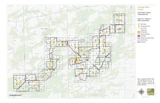
Figure 22-1. Impact to Plant Communities (Part 1)

  • 1. #* #* &=! &=! &=! &=! &=! &=! &=! &=! &=! &=! &=! &=! &=! &=! &=! &=! &=! &=! &=! &=! &=! &=! &=! &=! &=! &=! &=! &=! &=! &=! &=! &=! &=! 1 2 3 4 5 6 7 8 9 10 11 12 13 14 15 16 17 18 19 20 21 22 23 24 25 26 27 28 29 30 31 32 33 34 35 36 37 38 39 40 41 42 43 44 45 46 47 48 49 50 51 52 53 54 55 56 57 58 59 60 61 62 63 64 65 66 67 68 69 70 71 72 73 74 75 76 77 78 79 80 81 82 83 84 85 86 87 88 89 90 91 92 93 94 95 96 97 98 99 100 101 102 103 104 105 106 107 108 109 110 111 112 113 114 115 116 117 118 119 120 121 122 123 www.edrdpc.com µ Notes: 1. Basemap: ESRI ArcGIS Online "USGS Topo Map" map service. 2. This map was generated in ArcMap on February 12, 2020. 3. This is a color graphic. Reproduction in grayscale may misrepresent the data. Heritage Wind Project Town of Barre, Orleans County, New York Figure 22-1: Impact to Plant Communities &=! Wind Turbine #* Permanent Met Tower Access Road Collection Line POI Substation Collection Substation O&M Facility Laydown Area and Batch Plant Limit of Clearing Facility Site 0 2,000 4,0001,000 Feet
  • 2. &=! !( !(!( !( !( !(!( !( !( !( !( !( !( !( !( !( !( !( !( !( !( !( !( ROMUARVU ROMU LOMO ARVU LOMO RHCA ROMU ROMU RHCA RHCA T29 www.edrdpc.com µ Notes: 1. Basemap: NYSDOP "2015" orthoimagery map service. 2. This map was generated in ArcMap on February 12, 2020. 3. This is a color graphic. Reproduction in grayscale may misrepresent the data. Heritage Wind Project Town of Barre, Orleans County, New York Figure 22-1: Impact to Plant Communities !( Invasive Species &=! Wind Turbine Collection Line Access Road Limit of Clearing Facility Site Vegetative Community: Silver Maple-Ash Swamp Sheet 1 of 123 1:2,000 0 100 20050 Feet
  • 3. &=! !( !( !(!( !( !( ALPE ROMU ALPEALPE www.edrdpc.com µ Notes: 1. Basemap: NYSDOP "2015" orthoimagery map service. 2. This map was generated in ArcMap on February 12, 2020. 3. This is a color graphic. Reproduction in grayscale may misrepresent the data. Heritage Wind Project Town of Barre, Orleans County, New York Figure 22-1: Impact to Plant Communities !( Invasive Species Access Road Limit of Clearing Facility Site Vegetative Community: Silver Maple-Ash Swamp Sheet 2 of 123 1:2,000 0 100 20050 Feet
  • 4. &=! !( !(!( !( !( !(!( !( !( !( !( !( !( !( !( !( !( !( !( !( !( !( !( !( !( !( !( !( !( !( SWALLOWWORT RHCA PHAU VINCETOXICUM SPP VINCETOXICUM SPP ARVU ARVU ARVU RHCA LOMO RHCAARVU LOMO ROMU ARVU RHCA ARVU ARVU ARVU RHCA T30 www.edrdpc.com µ Notes: 1. Basemap: NYSDOP "2015" orthoimagery map service. 2. This map was generated in ArcMap on February 12, 2020. 3. This is a color graphic. Reproduction in grayscale may misrepresent the data. Heritage Wind Project Town of Barre, Orleans County, New York Figure 22-1: Impact to Plant Communities !( Invasive Species &=! Wind Turbine Collection Line Access Road Limit of Clearing Facility Site Vegetative Community: Silver Maple-Ash Swamp Sheet 3 of 123 1:2,000 0 100 20050 Feet
  • 5. &=! !( !( !( !( !(!( !( !( ARVU LOMO ROMU VINCETOXICUM SPP T33 www.edrdpc.com µ Notes: 1. Basemap: NYSDOP "2015" orthoimagery map service. 2. This map was generated in ArcMap on February 12, 2020. 3. This is a color graphic. Reproduction in grayscale may misrepresent the data. Heritage Wind Project Town of Barre, Orleans County, New York Figure 22-1: Impact to Plant Communities !( Invasive Species &=! Wind Turbine Collection Line Access Road Limit of Clearing Facility Site Vegetative Community: Successional Shrubland Silver Maple-Ash Swamp Sheet 4 of 123 1:2,000 0 100 20050 Feet
  • 6. !( !( !( !( !( !( !( !( !( !( !( !( !( !( !( CIAR LOMO CIAR LOMO ALPE CIAR ROPS CIAR RHCA ROPS LOMO www.edrdpc.com µ Notes: 1. Basemap: NYSDOP "2015" orthoimagery map service. 2. This map was generated in ArcMap on February 12, 2020. 3. This is a color graphic. Reproduction in grayscale may misrepresent the data. Heritage Wind Project Town of Barre, Orleans County, New York Figure 22-1: Impact to Plant Communities !( Invasive Species Collection Line Access Road Limit of Clearing Facility Site Vegetative Community: Disturbed/Developed Sheet 5 of 123 1:2,000 0 100 20050 Feet
  • 7. &=! !( !( !( !( !( !( !( UV31A CIAR LOMO CIAR CIAR T32 www.edrdpc.com µ Notes: 1. Basemap: NYSDOP "2015" orthoimagery map service. 2. This map was generated in ArcMap on February 12, 2020. 3. This is a color graphic. Reproduction in grayscale may misrepresent the data. Heritage Wind Project Town of Barre, Orleans County, New York Figure 22-1: Impact to Plant Communities !( Invasive Species &=! Wind Turbine Collection Line Access Road Limit of Clearing Facility Site Vegetative Community: Disturbed/Developed Successional Shrubland Sheet 6 of 123 1:2,000 0 100 20050 Feet
  • 8. Thorpe Rd www.edrdpc.com µ Notes: 1. Basemap: NYSDOP "2015" orthoimagery map service. 2. This map was generated in ArcMap on February 12, 2020. 3. This is a color graphic. Reproduction in grayscale may misrepresent the data. Heritage Wind Project Town of Barre, Orleans County, New York Figure 22-1: Impact to Plant Communities Facility Site Vegetative Community: Silver Maple-Ash Swamp Sheet 7 of 123 1:2,000 0 100 20050 Feet
  • 9. CR 36A MathesRd Thorpe Rd UV31A www.edrdpc.com µ Notes: 1. Basemap: NYSDOP "2015" orthoimagery map service. 2. This map was generated in ArcMap on February 12, 2020. 3. This is a color graphic. Reproduction in grayscale may misrepresent the data. Heritage Wind Project Town of Barre, Orleans County, New York Figure 22-1: Impact to Plant Communities Facility Site Vegetative Community: Disturbed/Developed Hayfield/Pasture Successional Southern Hardwoods Sheet 8 of 123 1:2,000 0 100 20050 Feet
  • 10. !( !( !( !( !( !( !( !(!( !( !( !( !( !( !( CR69 UV31A ALPE LOMO ROPS LOMO ALPE RHCA ROMU www.edrdpc.com µ Notes: 1. Basemap: NYSDOP "2015" orthoimagery map service. 2. This map was generated in ArcMap on February 12, 2020. 3. This is a color graphic. Reproduction in grayscale may misrepresent the data. Heritage Wind Project Town of Barre, Orleans County, New York Figure 22-1: Impact to Plant Communities !( Invasive Species Limit of Clearing Facility Site Vegetative Community: Disturbed/Developed Hayfield/Pasture Successional Old Field Successional Shrubland Successional Southern Hardwoods Pine Plantation Sheet 9 of 123 1:2,000 0 100 20050 Feet
  • 11. &=! !( !( !( !( !( !( !( !( UV31A CIAR LOMO ACPL ROPS T31 www.edrdpc.com µ Notes: 1. Basemap: NYSDOP "2015" orthoimagery map service. 2. This map was generated in ArcMap on February 12, 2020. 3. This is a color graphic. Reproduction in grayscale may misrepresent the data. Heritage Wind Project Town of Barre, Orleans County, New York Figure 22-1: Impact to Plant Communities !( Invasive Species &=! Wind Turbine Collection Line Access Road Limit of Clearing Facility Site Vegetative Community: Disturbed/Developed Successional Shrubland Successional Southern Hardwoods Sheet 10 of 123 1:2,000 0 100 20050 Feet
  • 12. Thorpe Rd CulverRd www.edrdpc.com µ Notes: 1. Basemap: NYSDOP "2015" orthoimagery map service. 2. This map was generated in ArcMap on February 12, 2020. 3. This is a color graphic. Reproduction in grayscale may misrepresent the data. Heritage Wind Project Town of Barre, Orleans County, New York Figure 22-1: Impact to Plant Communities Facility Site Vegetative Community: Disturbed/Developed Sheet 11 of 123 1:2,000 0 100 20050 Feet
  • 13. #* &=! Thorpe Rd MET-2 T28 www.edrdpc.com µ Notes: 1. Basemap: NYSDOP "2015" orthoimagery map service. 2. This map was generated in ArcMap on February 12, 2020. 3. This is a color graphic. Reproduction in grayscale may misrepresent the data. Heritage Wind Project Town of Barre, Orleans County, New York Figure 22-1: Impact to Plant Communities &=! Wind Turbine #* Permanent Met Tower Collection Line Access Road Facility Site Vegetative Community: Disturbed/Developed Sheet 12 of 123 1:2,000 0 100 20050 Feet
  • 14. &=! MathesRd www.edrdpc.com µ Notes: 1. Basemap: NYSDOP "2015" orthoimagery map service. 2. This map was generated in ArcMap on February 12, 2020. 3. This is a color graphic. Reproduction in grayscale may misrepresent the data. Heritage Wind Project Town of Barre, Orleans County, New York Figure 22-1: Impact to Plant Communities Collection Line Access Road Facility Site Vegetative Community: Disturbed/Developed Hayfield/Pasture Open Water Sheet 13 of 123 1:2,000 0 100 20050 Feet
  • 15. !( !( !( !( !( !( !( !( !(!( !( !( !( CR69 LOMO LOMO CEOR CEOR ARVU ROMU ROMU ROMU ROMUROMU ELUM www.edrdpc.com µ Notes: 1. Basemap: NYSDOP "2015" orthoimagery map service. 2. This map was generated in ArcMap on February 12, 2020. 3. This is a color graphic. Reproduction in grayscale may misrepresent the data. Heritage Wind Project Town of Barre, Orleans County, New York Figure 22-1: Impact to Plant Communities !( Invasive Species Collection Line Access Road Limit of Clearing Facility Site Vegetative Community: Disturbed/Developed Hayfield/Pasture Successional Shrubland Successional Southern Hardwoods Sheet 14 of 123 1:2,000 0 100 20050 Feet
  • 16. &=! !( !( !( www.edrdpc.com µ Notes: 1. Basemap: NYSDOP "2015" orthoimagery map service. 2. This map was generated in ArcMap on February 12, 2020. 3. This is a color graphic. Reproduction in grayscale may misrepresent the data. Heritage Wind Project Town of Barre, Orleans County, New York Figure 22-1: Impact to Plant Communities Collection Line Access Road Limit of Clearing Facility Site Vegetative Community: Successional Shrubland Successional Southern Hardwoods Sheet 15 of 123 1:2,000 0 100 20050 Feet
  • 17. LimeKilnRd CR 69 www.edrdpc.com µ Notes: 1. Basemap: NYSDOP "2015" orthoimagery map service. 2. This map was generated in ArcMap on February 12, 2020. 3. This is a color graphic. Reproduction in grayscale may misrepresent the data. Heritage Wind Project Town of Barre, Orleans County, New York Figure 22-1: Impact to Plant Communities Facility Site Sheet 16 of 123 1:2,000 0 100 20050 Feet
  • 18. www.edrdpc.com µ Notes: 1. Basemap: NYSDOP "2015" orthoimagery map service. 2. This map was generated in ArcMap on February 12, 2020. 3. This is a color graphic. Reproduction in grayscale may misrepresent the data. Heritage Wind Project Town of Barre, Orleans County, New York Figure 22-1: Impact to Plant Communities Facility Site Vegetative Community: Disturbed/Developed Sheet 17 of 123 1:2,000 0 100 20050 Feet
  • 19. !( !( LOMO LOMO www.edrdpc.com µ Notes: 1. Basemap: NYSDOP "2015" orthoimagery map service. 2. This map was generated in ArcMap on February 12, 2020. 3. This is a color graphic. Reproduction in grayscale may misrepresent the data. Heritage Wind Project Town of Barre, Orleans County, New York Figure 22-1: Impact to Plant Communities !( Invasive Species Collection Line Facility Site Vegetative Community: Disturbed/Developed Sheet 18 of 123 1:2,000 0 100 20050 Feet
  • 20. www.edrdpc.com µ Notes: 1. Basemap: NYSDOP "2015" orthoimagery map service. 2. This map was generated in ArcMap on February 12, 2020. 3. This is a color graphic. Reproduction in grayscale may misrepresent the data. Heritage Wind Project Town of Barre, Orleans County, New York Figure 22-1: Impact to Plant Communities Facility Site Sheet 19 of 123 1:2,000 0 100 20050 Feet
  • 21. www.edrdpc.com µ Notes: 1. Basemap: NYSDOP "2015" orthoimagery map service. 2. This map was generated in ArcMap on February 12, 2020. 3. This is a color graphic. Reproduction in grayscale may misrepresent the data. Heritage Wind Project Town of Barre, Orleans County, New York Figure 22-1: Impact to Plant Communities Facility Site Sheet 20 of 123 1:2,000 0 100 20050 Feet
  • 22. !( !( !( !( !( !( !( !( !( !( !( !( CEST ELUM CIAR CEST LOMO RHCA ELUM ROMU ELUM CIAR CIAR CIAR LOMO www.edrdpc.com µ Notes: 1. Basemap: NYSDOP "2015" orthoimagery map service. 2. This map was generated in ArcMap on February 12, 2020. 3. This is a color graphic. Reproduction in grayscale may misrepresent the data. Heritage Wind Project Town of Barre, Orleans County, New York Figure 22-1: Impact to Plant Communities !( Invasive Species Access Road Limit of Clearing Facility Site Vegetative Community: Disturbed/Developed Successional Shrubland Silver Maple-Ash Swamp Sheet 21 of 123 1:2,000 0 100 20050 Feet
  • 23. &=! !( !( !( !( !( !( CIAR CIAR CIAR T11 www.edrdpc.com µ Notes: 1. Basemap: NYSDOP "2015" orthoimagery map service. 2. This map was generated in ArcMap on February 12, 2020. 3. This is a color graphic. Reproduction in grayscale may misrepresent the data. Heritage Wind Project Town of Barre, Orleans County, New York Figure 22-1: Impact to Plant Communities !( Invasive Species &=! Wind Turbine Collection Line Access Road Limit of Clearing Facility Site Vegetative Community: Successional Shrubland Silver Maple-Ash Swamp Sheet 22 of 123 1:2,000 0 100 20050 Feet
  • 24. !( !( !( !( !( !( ALPE PHAU BETH, ROMU ACPL ROMU ALPE www.edrdpc.com µ Notes: 1. Basemap: NYSDOP "2015" orthoimagery map service. 2. This map was generated in ArcMap on February 12, 2020. 3. This is a color graphic. Reproduction in grayscale may misrepresent the data. Heritage Wind Project Town of Barre, Orleans County, New York Figure 22-1: Impact to Plant Communities !( Invasive Species Collection Line Access Road Laydown Area and Batch Plant Limit of Clearing Facility Site Vegetative Community: Disturbed/Developed Silver Maple-Ash Swamp Sheet 23 of 123 1:2,000 0 100 20050 Feet
  • 25. www.edrdpc.com µ Notes: 1. Basemap: NYSDOP "2015" orthoimagery map service. 2. This map was generated in ArcMap on February 12, 2020. 3. This is a color graphic. Reproduction in grayscale may misrepresent the data. Heritage Wind Project Town of Barre, Orleans County, New York Figure 22-1: Impact to Plant Communities Facility Site Vegetative Community: Disturbed/Developed Sheet 24 of 123 1:2,000 0 100 20050 Feet
  • 26. www.edrdpc.com µ Notes: 1. Basemap: NYSDOP "2015" orthoimagery map service. 2. This map was generated in ArcMap on February 12, 2020. 3. This is a color graphic. Reproduction in grayscale may misrepresent the data. Heritage Wind Project Town of Barre, Orleans County, New York Figure 22-1: Impact to Plant Communities Facility Site Sheet 25 of 123 1:2,000 0 100 20050 Feet
  • 27. www.edrdpc.com µ Notes: 1. Basemap: NYSDOP "2015" orthoimagery map service. 2. This map was generated in ArcMap on February 12, 2020. 3. This is a color graphic. Reproduction in grayscale may misrepresent the data. Heritage Wind Project Town of Barre, Orleans County, New York Figure 22-1: Impact to Plant Communities Facility Site Sheet 26 of 123 1:2,000 0 100 20050 Feet
  • 28. www.edrdpc.com µ Notes: 1. Basemap: NYSDOP "2015" orthoimagery map service. 2. This map was generated in ArcMap on February 12, 2020. 3. This is a color graphic. Reproduction in grayscale may misrepresent the data. Heritage Wind Project Town of Barre, Orleans County, New York Figure 22-1: Impact to Plant Communities Facility Site Sheet 27 of 123 1:2,000 0 100 20050 Feet
  • 29. &=! !( !( !( CIAR LOMO T22 www.edrdpc.com µ Notes: 1. Basemap: NYSDOP "2015" orthoimagery map service. 2. This map was generated in ArcMap on February 12, 2020. 3. This is a color graphic. Reproduction in grayscale may misrepresent the data. Heritage Wind Project Town of Barre, Orleans County, New York Figure 22-1: Impact to Plant Communities !( Invasive Species &=! Wind Turbine Collection Line Access Road Facility Site Sheet 28 of 123 1:2,000 0 100 20050 Feet
  • 30. &=! T24 www.edrdpc.com µ Notes: 1. Basemap: NYSDOP "2015" orthoimagery map service. 2. This map was generated in ArcMap on February 12, 2020. 3. This is a color graphic. Reproduction in grayscale may misrepresent the data. Heritage Wind Project Town of Barre, Orleans County, New York Figure 22-1: Impact to Plant Communities &=! Wind Turbine Collection Line Access Road Facility Site Sheet 29 of 123 1:2,000 0 100 20050 Feet
  • 31. #* !( !( !( MET-1 www.edrdpc.com µ Notes: 1. Basemap: NYSDOP "2015" orthoimagery map service. 2. This map was generated in ArcMap on February 12, 2020. 3. This is a color graphic. Reproduction in grayscale may misrepresent the data. Heritage Wind Project Town of Barre, Orleans County, New York Figure 22-1: Impact to Plant Communities #* Permanent Met Tower Collection Line Access Road Facility Site Sheet 30 of 123 1:2,000 0 100 20050 Feet
  • 32. &=! !( !( !( !( !( !( !( !( !( !( !( !( !( !( !( !( !( !( !( !( !( !( !( !( !( PHRAGMITES PATCH CIAR PHAU PHAU PHAU LOMO ROMU ELUM ELUM CIAR ELUM CIAR CIAR CIAR ELUM CIAR ROMU RHCA CIAR CEST CIAR CIAR CIAR ACPL LOMO ELUM LOMO CIAR T9 www.edrdpc.com µ Notes: 1. Basemap: NYSDOP "2015" orthoimagery map service. 2. This map was generated in ArcMap on February 12, 2020. 3. This is a color graphic. Reproduction in grayscale may misrepresent the data. Heritage Wind Project Town of Barre, Orleans County, New York Figure 22-1: Impact to Plant Communities !( Invasive Species &=! Wind Turbine Collection Line Access Road Limit of Clearing Facility Site Vegetative Community: Successional Shrubland Silver Maple-Ash Swamp Successional Southern Hardwoods Sheet 31 of 123 1:2,000 0 100 20050 Feet
  • 33. &=! &=! !( !( !( !( !( !( !( !( !( !( !( !(!( !( !( !( !( !( !( !( !( ROMU CIAR LOMO CIAR RHCA RHCA ROMU LOMO ROMU ROMU CIARCIAR ROMU ROMU PHAU T10 T12 www.edrdpc.com µ Notes: 1. Basemap: NYSDOP "2015" orthoimagery map service. 2. This map was generated in ArcMap on February 12, 2020. 3. This is a color graphic. Reproduction in grayscale may misrepresent the data. Heritage Wind Project Town of Barre, Orleans County, New York Figure 22-1: Impact to Plant Communities !( Invasive Species &=! Wind Turbine Collection Line Access Road Limit of Clearing Facility Site Vegetative Community: Successional Shrubland Silver Maple-Ash Swamp Successional Southern Hardwoods Sheet 32 of 123 1:2,000 0 100 20050 Feet
  • 34. &=! !( !( !( !( !( !( !( !( !( !( !( !( !( !(!(!(!( !( !( !( !( LOMO ROM CIAR CIAR CIAR LOMO ALPE LOMO ALPE CIAR ALPEALPECIARRHCA ROMU CIAR CIAR ROMU ROMU www.edrdpc.com µ Notes: 1. Basemap: NYSDOP "2015" orthoimagery map service. 2. This map was generated in ArcMap on February 12, 2020. 3. This is a color graphic. Reproduction in grayscale may misrepresent the data. Heritage Wind Project Town of Barre, Orleans County, New York Figure 22-1: Impact to Plant Communities !( Invasive Species Collection Line Laydown Area and Batch Plant Limit of Clearing Facility Site Vegetative Community: Disturbed/Developed Successional Shrubland Silver Maple-Ash Swamp Sheet 33 of 123 1:2,000 0 100 20050 Feet
  • 35. &=! !( !( ARVU LOMO T14 www.edrdpc.com µ Notes: 1. Basemap: NYSDOP "2015" orthoimagery map service. 2. This map was generated in ArcMap on February 12, 2020. 3. This is a color graphic. Reproduction in grayscale may misrepresent the data. Heritage Wind Project Town of Barre, Orleans County, New York Figure 22-1: Impact to Plant Communities !( Invasive Species &=! Wind Turbine Collection Line Access Road Facility Site Vegetative Community: Disturbed/Developed Sheet 34 of 123 1:2,000 0 100 20050 Feet
  • 36. &=! www.edrdpc.com µ Notes: 1. Basemap: NYSDOP "2015" orthoimagery map service. 2. This map was generated in ArcMap on February 12, 2020. 3. This is a color graphic. Reproduction in grayscale may misrepresent the data. Heritage Wind Project Town of Barre, Orleans County, New York Figure 22-1: Impact to Plant Communities Collection Line Access Road Facility Site Sheet 35 of 123 1:2,000 0 100 20050 Feet
  • 37. !( !(!( www.edrdpc.com µ Notes: 1. Basemap: NYSDOP "2015" orthoimagery map service. 2. This map was generated in ArcMap on February 12, 2020. 3. This is a color graphic. Reproduction in grayscale may misrepresent the data. Heritage Wind Project Town of Barre, Orleans County, New York Figure 22-1: Impact to Plant Communities Collection Line Facility Site Sheet 36 of 123 1:2,000 0 100 20050 Feet
  • 38. !( !( !( CIAR www.edrdpc.com µ Notes: 1. Basemap: NYSDOP "2015" orthoimagery map service. 2. This map was generated in ArcMap on February 12, 2020. 3. This is a color graphic. Reproduction in grayscale may misrepresent the data. Heritage Wind Project Town of Barre, Orleans County, New York Figure 22-1: Impact to Plant Communities !( Invasive Species Collection Line Limit of Clearing Facility Site Vegetative Community: Successional Southern Hardwoods Sheet 37 of 123 1:2,000 0 100 20050 Feet
  • 39. &=! &=! !( !( !(!( !( !( !( !( !( LOMO CIAR LOMOLOMO POSSIBLE SACI, SEE PHOTOS 7/30/19 LOMO CIAR CIAR CIAR, LOMO T23 T26 www.edrdpc.com µ Notes: 1. Basemap: NYSDOP "2015" orthoimagery map service. 2. This map was generated in ArcMap on February 12, 2020. 3. This is a color graphic. Reproduction in grayscale may misrepresent the data. Heritage Wind Project Town of Barre, Orleans County, New York Figure 22-1: Impact to Plant Communities !( Invasive Species &=! Wind Turbine Collection Line Access Road Limit of Clearing Facility Site Vegetative Community: Silver Maple-Ash Swamp Sheet 38 of 123 1:2,000 0 100 20050 Feet
  • 40. www.edrdpc.com µ Notes: 1. Basemap: NYSDOP "2015" orthoimagery map service. 2. This map was generated in ArcMap on February 12, 2020. 3. This is a color graphic. Reproduction in grayscale may misrepresent the data. Heritage Wind Project Town of Barre, Orleans County, New York Figure 22-1: Impact to Plant Communities Facility Site Sheet 39 of 123 1:2,000 0 100 20050 Feet
  • 41. www.edrdpc.com µ Notes: 1. Basemap: NYSDOP "2015" orthoimagery map service. 2. This map was generated in ArcMap on February 12, 2020. 3. This is a color graphic. Reproduction in grayscale may misrepresent the data. Heritage Wind Project Town of Barre, Orleans County, New York Figure 22-1: Impact to Plant Communities Facility Site Vegetative Community: Successional Southern Hardwoods Sheet 40 of 123 1:2,000 0 100 20050 Feet
  • 42. !( !( !( !( !( !( !( ROMU RHCA ROMU LOMO LOMO ROMU RHCA www.edrdpc.com µ Notes: 1. Basemap: NYSDOP "2015" orthoimagery map service. 2. This map was generated in ArcMap on February 12, 2020. 3. This is a color graphic. Reproduction in grayscale may misrepresent the data. Heritage Wind Project Town of Barre, Orleans County, New York Figure 22-1: Impact to Plant Communities !( Invasive Species Collection Line Limit of Clearing Facility Site Vegetative Community: Successional Shrubland Silver Maple-Ash Swamp Successional Southern Hardwoods Sheet 41 of 123 1:2,000 0 100 20050 Feet
  • 43. &=! www.edrdpc.com µ Notes: 1. Basemap: NYSDOP "2015" orthoimagery map service. 2. This map was generated in ArcMap on February 12, 2020. 3. This is a color graphic. Reproduction in grayscale may misrepresent the data. Heritage Wind Project Town of Barre, Orleans County, New York Figure 22-1: Impact to Plant Communities Collection Line Facility Site Sheet 42 of 123 1:2,000 0 100 20050 Feet
  • 44. &=! !( !(!(!( !( PHAR LOMOCIAR LOMO CIAR T15 www.edrdpc.com µ Notes: 1. Basemap: NYSDOP "2015" orthoimagery map service. 2. This map was generated in ArcMap on February 12, 2020. 3. This is a color graphic. Reproduction in grayscale may misrepresent the data. Heritage Wind Project Town of Barre, Orleans County, New York Figure 22-1: Impact to Plant Communities !( Invasive Species &=! Wind Turbine Collection Line Access Road Facility Site Vegetative Community: Disturbed/Developed Successional Southern Hardwoods Open Water Sheet 43 of 123 1:2,000 0 100 20050 Feet
  • 45. &=! !( !( ALPE ALPE T17 www.edrdpc.com µ Notes: 1. Basemap: NYSDOP "2015" orthoimagery map service. 2. This map was generated in ArcMap on February 12, 2020. 3. This is a color graphic. Reproduction in grayscale may misrepresent the data. Heritage Wind Project Town of Barre, Orleans County, New York Figure 22-1: Impact to Plant Communities !( Invasive Species &=! Wind Turbine Collection Line Access Road Limit of Clearing Facility Site Vegetative Community: Mowed Roadside/Pathway Silver Maple-Ash Swamp Successional Southern Hardwoods Sheet 44 of 123 1:2,000 0 100 20050 Feet
  • 46. !( !( !( !(!( !( ROMU LOMO, CIARROMU RHCA www.edrdpc.com µ Notes: 1. Basemap: NYSDOP "2015" orthoimagery map service. 2. This map was generated in ArcMap on February 12, 2020. 3. This is a color graphic. Reproduction in grayscale may misrepresent the data. Heritage Wind Project Town of Barre, Orleans County, New York Figure 22-1: Impact to Plant Communities !( Invasive Species Collection Line Limit of Clearing Facility Site Vegetative Community: Mowed Roadside/Pathway Silver Maple-Ash Swamp Successional Southern Hardwoods Sheet 45 of 123 1:2,000 0 100 20050 Feet
  • 47. !( www.edrdpc.com µ Notes: 1. Basemap: NYSDOP "2015" orthoimagery map service. 2. This map was generated in ArcMap on February 12, 2020. 3. This is a color graphic. Reproduction in grayscale may misrepresent the data. Heritage Wind Project Town of Barre, Orleans County, New York Figure 22-1: Impact to Plant Communities Facility Site Vegetative Community: Successional Southern Hardwoods Sheet 46 of 123 1:2,000 0 100 20050 Feet
  • 48. &=! !(!( !( !( !( !( !( !(!( !( ARVUROPS ARVUROPS ALPE T27 www.edrdpc.com µ Notes: 1. Basemap: NYSDOP "2015" orthoimagery map service. 2. This map was generated in ArcMap on February 12, 2020. 3. This is a color graphic. Reproduction in grayscale may misrepresent the data. Heritage Wind Project Town of Barre, Orleans County, New York Figure 22-1: Impact to Plant Communities !( Invasive Species &=! Wind Turbine Collection Line Access Road Limit of Clearing Facility Site Vegetative Community: Silver Maple-Ash Swamp Sheet 47 of 123 1:2,000 0 100 20050 Feet
  • 49. !( !( !(!(!(!(!(!( !( !( !( !( !( !( !( RHCA CIAR RHCAARVURHCARHCA ROMU ROPS RHCA ROMU PHAU RHCA CEOR ARVU ARVU www.edrdpc.com µ Notes: 1. Basemap: NYSDOP "2015" orthoimagery map service. 2. This map was generated in ArcMap on February 12, 2020. 3. This is a color graphic. Reproduction in grayscale may misrepresent the data. Heritage Wind Project Town of Barre, Orleans County, New York Figure 22-1: Impact to Plant Communities !( Invasive Species Access Road Facility Site Vegetative Community: Silver Maple-Ash Swamp Sheet 48 of 123 1:2,000 0 100 20050 Feet
  • 50. !( !( !( !( !( !( !( !( !( !( ARVU ALPE ALPE LOMO RHCA LOMO CIAR LOMO LOMO www.edrdpc.com µ Notes: 1. Basemap: NYSDOP "2015" orthoimagery map service. 2. This map was generated in ArcMap on February 12, 2020. 3. This is a color graphic. Reproduction in grayscale may misrepresent the data. Heritage Wind Project Town of Barre, Orleans County, New York Figure 22-1: Impact to Plant Communities !( Invasive Species Collection Line Limit of Clearing Facility Site Vegetative Community: Disturbed/Developed Successional Shrubland Sheet 49 of 123 1:2,000 0 100 20050 Feet
  • 51. www.edrdpc.com µ Notes: 1. Basemap: NYSDOP "2015" orthoimagery map service. 2. This map was generated in ArcMap on February 12, 2020. 3. This is a color graphic. Reproduction in grayscale may misrepresent the data. Heritage Wind Project Town of Barre, Orleans County, New York Figure 22-1: Impact to Plant Communities Facility Site Sheet 50 of 123 1:2,000 0 100 20050 Feet
  • 52. !( !( !( CIAR www.edrdpc.com µ Notes: 1. Basemap: NYSDOP "2015" orthoimagery map service. 2. This map was generated in ArcMap on February 12, 2020. 3. This is a color graphic. Reproduction in grayscale may misrepresent the data. Heritage Wind Project Town of Barre, Orleans County, New York Figure 22-1: Impact to Plant Communities !( Invasive Species Collection Line Facility Site Vegetative Community: Successional Shrubland Silver Maple-Ash Swamp Sheet 51 of 123 1:2,000 0 100 20050 Feet
  • 53. &=! !( !( !( !( !( !( !( !( !( !( !( !( !( CIAR LOMO ROMU RHCA LOMO LOMO ARVU ARVU LOMO ROMU PHAU CIAR PHAU T20 www.edrdpc.com µ Notes: 1. Basemap: NYSDOP "2015" orthoimagery map service. 2. This map was generated in ArcMap on February 12, 2020. 3. This is a color graphic. Reproduction in grayscale may misrepresent the data. Heritage Wind Project Town of Barre, Orleans County, New York Figure 22-1: Impact to Plant Communities !( Invasive Species &=! Wind Turbine Collection Line Access Road Limit of Clearing Facility Site Vegetative Community: Mowed Roadside/Pathway Silver Maple-Ash Swamp Successional Southern Hardwoods Spruce/Fir Plantation Open Water Sheet 52 of 123 1:2,000 0 100 20050 Feet
  • 54. www.edrdpc.com µ Notes: 1. Basemap: NYSDOP "2015" orthoimagery map service. 2. This map was generated in ArcMap on February 12, 2020. 3. This is a color graphic. Reproduction in grayscale may misrepresent the data. Heritage Wind Project Town of Barre, Orleans County, New York Figure 22-1: Impact to Plant Communities Facility Site Vegetative Community: Silver Maple-Ash Swamp Sheet 53 of 123 1:2,000 0 100 20050 Feet
  • 55. !( !( !( RHCA www.edrdpc.com µ Notes: 1. Basemap: NYSDOP "2015" orthoimagery map service. 2. This map was generated in ArcMap on February 12, 2020. 3. This is a color graphic. Reproduction in grayscale may misrepresent the data. Heritage Wind Project Town of Barre, Orleans County, New York Figure 22-1: Impact to Plant Communities !( Invasive Species Facility Site Vegetative Community: Successional Shrubland Silver Maple-Ash Swamp Sheet 54 of 123 1:2,000 0 100 20050 Feet
  • 56. &=! !( !( !( !( !( !( !( !( !( !( !( LOMO RHCA CIAR PHAU ROMU RHCA ALPE ARVU ALPE ALPE, RHCA T25 www.edrdpc.com µ Notes: 1. Basemap: NYSDOP "2015" orthoimagery map service. 2. This map was generated in ArcMap on February 12, 2020. 3. This is a color graphic. Reproduction in grayscale may misrepresent the data. Heritage Wind Project Town of Barre, Orleans County, New York Figure 22-1: Impact to Plant Communities !( Invasive Species &=! Wind Turbine Collection Line Access Road Limit of Clearing Facility Site Vegetative Community: Successional Shrubland Silver Maple-Ash Swamp Sheet 55 of 123 1:2,000 0 100 20050 Feet
  • 57. www.edrdpc.com µ Notes: 1. Basemap: NYSDOP "2015" orthoimagery map service. 2. This map was generated in ArcMap on February 12, 2020. 3. This is a color graphic. Reproduction in grayscale may misrepresent the data. Heritage Wind Project Town of Barre, Orleans County, New York Figure 22-1: Impact to Plant Communities Facility Site Vegetative Community: Silver Maple-Ash Swamp Successional Southern Hardwoods Sheet 56 of 123 1:2,000 0 100 20050 Feet
  • 58. www.edrdpc.com µ Notes: 1. Basemap: NYSDOP "2015" orthoimagery map service. 2. This map was generated in ArcMap on February 12, 2020. 3. This is a color graphic. Reproduction in grayscale may misrepresent the data. Heritage Wind Project Town of Barre, Orleans County, New York Figure 22-1: Impact to Plant Communities Facility Site Vegetative Community: Successional Southern Hardwoods Sheet 57 of 123 1:2,000 0 100 20050 Feet
  • 59. !( !( !( !( !( !( !( !( LOMO ALPE RHCA ROMA RHCA ALPE LOMO LOMO www.edrdpc.com µ Notes: 1. Basemap: NYSDOP "2015" orthoimagery map service. 2. This map was generated in ArcMap on February 12, 2020. 3. This is a color graphic. Reproduction in grayscale may misrepresent the data. Heritage Wind Project Town of Barre, Orleans County, New York Figure 22-1: Impact to Plant Communities !( Invasive Species Collection Line Limit of Clearing Facility Site Vegetative Community: Silver Maple-Ash Swamp Successional Southern Hardwoods Sheet 58 of 123 1:2,000 0 100 20050 Feet
  • 60. www.edrdpc.com µ Notes: 1. Basemap: NYSDOP "2015" orthoimagery map service. 2. This map was generated in ArcMap on February 12, 2020. 3. This is a color graphic. Reproduction in grayscale may misrepresent the data. Heritage Wind Project Town of Barre, Orleans County, New York Figure 22-1: Impact to Plant Communities Facility Site Vegetative Community: Silver Maple-Ash Swamp Sheet 59 of 123 1:2,000 0 100 20050 Feet
  • 61. !( !(PHAU www.edrdpc.com µ Notes: 1. Basemap: NYSDOP "2015" orthoimagery map service. 2. This map was generated in ArcMap on February 12, 2020. 3. This is a color graphic. Reproduction in grayscale may misrepresent the data. Heritage Wind Project Town of Barre, Orleans County, New York Figure 22-1: Impact to Plant Communities !( Invasive Species Facility Site Vegetative Community: Silver Maple-Ash Swamp Sheet 60 of 123 1:2,000 0 100 20050 Feet
  • 62. !( !( !( !( !( !( !( !( !( !( !( !( !( !( !( !( !( !( !( PHAU PHAU LOMO RHCA PHAU LOMO RHCA ROMU CIAR CIAR CIARCIAR ROMU ROMU ROMU CIAR PHAU www.edrdpc.com µ Notes: 1. Basemap: NYSDOP "2015" orthoimagery map service. 2. This map was generated in ArcMap on February 12, 2020. 3. This is a color graphic. Reproduction in grayscale may misrepresent the data. Heritage Wind Project Town of Barre, Orleans County, New York Figure 22-1: Impact to Plant Communities !( Invasive Species Collection Line POI Substation Limit of Clearing Facility Site Vegetative Community: Disturbed/Developed Successional Shrubland Silver Maple-Ash Swamp Sheet 61 of 123 1:2,000 0 100 20050 Feet