
Recommended
Recommended
More Related Content
More from Heritage Wind
More from Heritage Wind (20)
Recently uploaded
Recently uploaded (20)
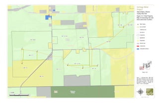
Figure 13 1. Real Property Map
- 1. &=! &=! &=! &=! &=! &=! &=! W Barre Rd Gillette Rd Hemlock Ridge Rd DrakeIslandRd HillRd Root Rd AlbionRd Eagle HarborRd Genesee County Orleans County Town of Barre Town of ElbaTown of Oakfield 126.-1-8 116.-1-38 116.-1-30.11 126.-1-8 127.-1-1.1 127.-1-2.112 127.-1-2.112 116.-1-47 116.-1-47 115.-1-22.2 127.-1-4 126.-1-7.1 126.-1-7.2 T1 T2 T3 T4 T5 T6 T7 0 1,000 2,000500 Feet www.edrdpc.com µ Heritage Wind Project Town of Barre, Orleans County, New York Figure 13-1: Real Property Map of Generating Site and Interconnection Facilities &=! Wind Turbine Access Road Collection Line Tax Parcel Facility Site Agricultural Residential Vacant Land Commercial Community Services 1:12,000 Sheet 1 of 6 Notes: 1. Basemap:"USGS TNM Topo Base Map" displayed via the USGS Topo Map Service. 2. Land use shown is derived from county parcel data. 3. This map was generated in ArcMap on February 12, 2020. 4. This is a color graphic.
- 2. &=! &=! &=! &=! &=! &=! Delano Steele Rd CushingRd G illette Rd BraggSchoolhouseRd Root Rd W Barre Rd Puzzey Rd O ak O rchard Rd QuakerHillRd ST98 Orleans County Town of Barre 117.-1-33.1 117.-1-34 106.-1-76.12 117.-1-23 117.-1-36.1 116.-1-14.121 117.-1-24.212 116.-1-38 116.-1-30.11 116.-1-47 106.-1-39 116.-1-13.22 116.-1-14.122 105.-1-19.1 106.-1-36.1 105.-1-19.1 117.-1-25.11 117.-1-25.11 106.-1-36.1 106.-1-36.1 T7 T8 T13 T16 T18 0 1,000 2,000500 Feet www.edrdpc.com µ Heritage Wind Project Town of Barre, Orleans County, New York Figure 13-1: Real Property Map of Generating Site and Interconnection Facilities &=! Wind Turbine Access Road Collection Line POI Substation Collection Substation O&M Facility Tax Parcel Facility Site Agricultural Residential Vacant Land Public Services 1:12,000 Sheet 2 of 6 Notes: 1. Basemap:"USGS TNM Topo Base Map" displayed via the USGS Topo Map Service. 2. Land use shown is derived from county parcel data. 3. This map was generated in ArcMap on February 12, 2020. 4. This is a color graphic.
- 3. &=! &=! &=! &=! &=! &=! &=! &=! #* Maple St Allis Rd CR 99 W Barre Road Ext W Barre Rd CushingRd BraggSchoolhouseRd O ak O rchard Rd E Barre Rd QuakerHillRd ST98 Orleans County Town of Barre 106.-1-76.12 117.-1-23 106.-1-6 116.-1-14.121 117.-1-24.212 106.-1-39 116.-1-13.22 105.-1-19.1 106.-1-1.111 106.-1-64.1 106.-1-36.1 106.-1-5 105.-1-17.21 106.-1-1.112 105.-1-19.1 117.-1-25.11 106.-1-36.1 106.-1-36.1 T9 T10 T11 T12 T14 T15 0 1,000 2,000500 Feet www.edrdpc.com µ Heritage Wind Project Town of Barre, Orleans County, New York Figure 13-1: Real Property Map of Generating Site and Interconnection Facilities &=! Wind Turbine #* Permanent Met Tower Access Road Collection Line POI Substation Laydown Yard Tax Parcel Facility Site Agricultural Residential Vacant Land Commercial Community Services Public Services 1:12,000 Sheet 3 of 6 Notes: 1. Basemap:"USGS TNM Topo Base Map" displayed via the USGS Topo Map Service. 2. Land use shown is derived from county parcel data. 3. This map was generated in ArcMap on February 12, 2020. 4. This is a color graphic.
- 4. &=! &=! &=! &=! HundredmarkRd Spoils Bank Rd WhiteCityRdRootIslandRd Jakaub Rd Delano Steele Rd Sheelar Rd W M uck R d AngevineRd Oak Orchard Rd E Oak Orchard Rd Genesee County Orleans County Town of Barre Town of Elba 117.-1-33.1 117.-1-34 117.-1-36.1 118.-1-41.13 118.-1-43.2 118.-1-4.112 118.-1-43.12 118.-1-9 118.-1-14.2 118.-1-14.2117.-1-25.11 118.-1-41.122 T16 T18 T21 0 1,000 2,000500 Feet www.edrdpc.com µ Heritage Wind Project Town of Barre, Orleans County, New York Figure 13-1: Real Property Map of Generating Site and Interconnection Facilities &=! Wind Turbine Access Road Collection Line Tax Parcel Facility Site Agricultural Residential Vacant Land Commercial Wild, Forested, Conservation Lands and Public Parks 1:12,000 Sheet 4 of 6 Notes: 1. Basemap:"USGS TNM Topo Base Map" displayed via the USGS Topo Map Service. 2. Land use shown is derived from county parcel data. 3. This map was generated in ArcMap on February 12, 2020. 4. This is a color graphic.
- 5. &=! &=! &=! &=! &=! &=! &=! &=! &=! &=! &=! CulverRd Angevine Rd Puzzey Rd CushingRd Oak Orchard Rd E Barre Rd Orleans County Town of Barre 117.-1-23 106.-1-6 117.-1-24.212 118.-1-43.12 118.-1-9 118.-1-14.2 118.-1-14.2 106.-1-39 107.-1-66 107.-1-50 106.-1-22.2 107.-1-49.2 106.-1-36.1 107.-1-11.12107.-1-5 107.-1-6.21 107.-1-10.1 117.-1-25.11 117.-1-25.11 107.-1-58.21 107.-1-58.21 106.-1-32 106.-1-36.1 106.-1-22.2 106.-1-36.1 107.-1-71.2 107.-1-11.2 T14 T15 T17 T19 T20 T22 T23 T24 T25 T26 T27 0 1,000 2,000500 Feet www.edrdpc.com µ Heritage Wind Project Town of Barre, Orleans County, New York Figure 13-1: Real Property Map of Generating Site and Interconnection Facilities &=! Wind Turbine Access Road Collection Line POI Substation Collection Substation O&M Facility Tax Parcel Facility Site Agricultural Residential Vacant Land 1:12,000 Sheet 5 of 6 Notes: 1. Basemap:"USGS TNM Topo Base Map" displayed via the USGS Topo Map Service. 2. Land use shown is derived from county parcel data. 3. This map was generated in ArcMap on February 12, 2020. 4. This is a color graphic.
- 6. &=! &=! &=! &=! &=! &=! &=! &=! #* Thorpe Rd CR 36A CulverRd AngevineRd MathesRd E Barre Rd ELeeRd ST31A Orleans County Town of Barre Town of Clarendon 96.-1-71 107.-1-5 107.-1-6.21 107.-1-10.1 96.-1-14.11 96.-1-13 96.-1-37.121 96.-1-12.1 96.-1-9 96.-1-10 96.-1-45 96.-1-45 T24 T28 T29 T30 T31 T32 T33 0 1,000 2,000500 Feet www.edrdpc.com µ Heritage Wind Project Town of Barre, Orleans County, New York Figure 13-1: Real Property Map of Generating Site and Interconnection Facilities &=! Wind Turbine #* Permanent Met Tower Access Road Collection Line Tax Parcel Facility Site Agricultural Residential Vacant Land Commercial Community Services Wild, Forested, Conservation Lands and Public Parks 1:12,000 Sheet 6 of 6 Notes: 1. Basemap:"USGS TNM Topo Base Map" displayed via the USGS Topo Map Service. 2. Land use shown is derived from county parcel data. 3. This map was generated in ArcMap on February 12, 2020. 4. This is a color graphic.