Max. shear stress theory-Maximum Shear Stress Theory Maximum Distortional ...
Figure 23-2. Surface Waters
1. &=!
&=!
&=!
&=!
&=!
&=!
&=!
&=!
ClassC
Class C
Class C
ClassC
Class C
Class C
ClassC
Class C
ClassC
ClassA
Class C
Class C
Class C
Class C
ClassC
Class C
Class C
Class C
ClassC
T1
T2
T3
T4
T5
T6
T7
T8
0 2,000 4,0001,000
Feet
www.edrdpc.com
µ
Notes: 1. Basemap: "USGS TNM Topo
Base Map" displayed via the USGS Topo
Map Service. 2. This map was generated
in ArcMap on February 12, 2020. 3. This is
a color graphic. Reproduction in grayscale
may misrepresent the data. 4. Locations of
private well locations are approximate.
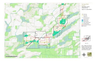
Heritage Wind
Project
Town of Barre, Orleans
County, New York
Figure 23-2: Surface Waters
&=!
Wind Turbine
Access Road
Collection Line
NYS Protected Stream
Unprotected Stream
Delineated Stream
Delineated Wetland
NYSDEC Mapped Wetland
NWI Mapped Wetland
500-foot Wetland Study Area
Facility Site
1:24,000
Sheet 1 of 4
2. #*
#*
&=!
&=!
&=!
&=!
&=!
&=!
&=!
&=!
&=!
&=!
&=!
Class A
Class A
Class A
ClassA
Class A
ClassC
ClassC
ClassC
ClassC
Class C
Class C
Class C
ClassA
Class C
ClassA
ClassA
ClassC
ClassC
T8
T9
T10
T11
T12
T13
T14
T15
T17
T20
T22
0 2,000 4,0001,000
Feet
www.edrdpc.com
µ
Notes: 1. Basemap: "USGS TNM Topo
Base Map" displayed via the USGS Topo
Map Service. 2. This map was generated
in ArcMap on February 12, 2020. 3. This is
a color graphic. Reproduction in grayscale
may misrepresent the data. 4. Locations of
private well locations are approximate.
Heritage Wind
Project
Town of Barre, Orleans
County, New York
Figure 23-2: Surface Waters
&=!
Wind Turbine
#* Permanent Met Tower
Access Road
Collection Line
NYS Protected Stream
Unprotected Stream
POI Substation
Collection Substation
O&M Facility
Laydown Yard
Delineated Stream
Delineated Wetland
NYSDEC Mapped Wetland
NWI Mapped Wetland
500-foot Wetland Study Area
Facility Site
1:24,000
Sheet 2 of 4
3. #*
&=!
&=!
&=!
&=!
&=!
&=!
&=!
&=!
&=!
&=!
&=!
&=!
&=!
&=!
&=!
&=!
ClassC
ClassC
Class C
Class C
ClassC
Class C
Class C
Class C
Class C
Class C
Class C
Class C
Class C
ClassC
T14
T15
T17
T20
T22
T23
T24
T25
T26
T27
T28
T29
T30
T31
T32
T33
0 2,000 4,0001,000
Feet
www.edrdpc.com
µ
Notes: 1. Basemap: "USGS TNM Topo
Base Map" displayed via the USGS Topo
Map Service. 2. This map was generated
in ArcMap on February 12, 2020. 3. This is
a color graphic. Reproduction in grayscale
may misrepresent the data. 4. Locations of
private well locations are approximate.
Heritage Wind
Project
Town of Barre, Orleans
County, New York
Figure 23-2: Surface Waters
&=!
Wind Turbine
#* Permanent Met Tower
Access Road
Collection Line
Unprotected Stream
Laydown Yard
Delineated Stream
Delineated Wetland
NYSDEC Mapped Wetland
NWI Mapped Wetland
500-foot Wetland Study Area
Facility Site
1:24,000
Sheet 3 of 4
4. &=!
&=!
&=!
&=!
&=!
&=!
&=!
&=!
&=!
&=!
&=!
&=!
&=!
&=!
&=!
&=!
Class C
Class C
Class C
Class C
Class C
ClassC
Class C
ClassC
Class C
Class C
Class C
ClassC
Class C
Class C
Class C
ClassC
ClassC
Class C
Class C
T12
T13
T14
T15
T16
T17
T18
T19
T20
T21
T23
T25
T26
T27
0 2,000 4,0001,000
Feet
www.edrdpc.com
µ
Notes: 1. Basemap: "USGS TNM Topo
Base Map" displayed via the USGS Topo
Map Service. 2. This map was generated
in ArcMap on February 12, 2020. 3. This is
a color graphic. Reproduction in grayscale
may misrepresent the data. 4. Locations of
private well locations are approximate.
Heritage Wind
Project
Town of Barre, Orleans
County, New York
Figure 23-2: Surface Waters
&=!
Wind Turbine
Access Road
Collection Line
Unprotected Stream
POI Substation
Collection Substation
O&M Facility
Laydown Yard
Delineated Stream
Delineated Wetland
NYSDEC Mapped Wetland
NWI Mapped Wetland
500-foot Wetland Study Area
Facility Site
1:24,000
Sheet 4 of 4