Maximizing Incident Investigation Efficacy in Oil & Gas: Techniques and Tools
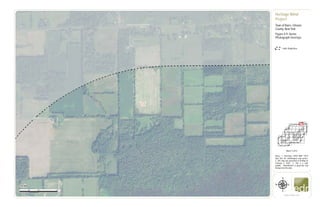
Figure 4-9. Aerial Photograph Overlays
1. Town of
Albion
TuthillRd
County House Rd
CR 76
0 500 1,000250
Feet
www.edrdpc.com
µ
Notes: 1. Basemap: USDA NAIP "2019
New York 1m" orthoimagery map service.
2. This map was generated in ArcMap on
February 3, 2020. 3. This is a color
graphic. Reproduction in grayscale may
misrepresent the data.
Heritage Wind
Project
Town of Barre, Orleans
County, New York
Figure 4-9: Aerial
Photograph Overlays
!
!
!
!
!
!
!
!
! !
!
!
!!
!
!
!
!
!!
!
!!
!
1:6,000
Sheet 1 of 51
1-mile Study Area
2. Town of
Albion
Town of
Murray
HindsburgRdCR91
CR 76
0 500 1,000250
Feet
www.edrdpc.com
µ
Notes: 1. Basemap: USDA NAIP "2019
New York 1m" orthoimagery map service.
2. This map was generated in ArcMap on
February 3, 2020. 3. This is a color
graphic. Reproduction in grayscale may
misrepresent the data.
Heritage Wind
Project
Town of Barre, Orleans
County, New York
Figure 4-9: Aerial
Photograph Overlays
!
!
!
!
!
!
!
!
! !
!
!
!!
!
!
!
!
!!
!
!!
!
1:6,000
Sheet 2 of 51
1-mile Study Area
3. Town of
Albion
Town of Barre
County House Rd
CR 56
UV31A
UV98
0 500 1,000250
Feet
www.edrdpc.com
µ
Notes: 1. Basemap: USDA NAIP "2019
New York 1m" orthoimagery map service.
2. This map was generated in ArcMap on
February 3, 2020. 3. This is a color
graphic. Reproduction in grayscale may
misrepresent the data.
Heritage Wind
Project
Town of Barre, Orleans
County, New York
Figure 4-9: Aerial
Photograph Overlays
!
!
!
!
!
!
!
!
! !
!
!
!!
!
!
!
!
!!
!
!!
!
1:6,000
Sheet 3 of 51
Limit of Clearing
Limit of Disturbance
1-mile Study Area
4. Town of
Albion
Town of Barre
LewisRd
ClarendonRd
County House Rd
UV31A
0 500 1,000250
Feet
www.edrdpc.com
µ
Notes: 1. Basemap: USDA NAIP "2019
New York 1m" orthoimagery map service.
2. This map was generated in ArcMap on
February 3, 2020. 3. This is a color
graphic. Reproduction in grayscale may
misrepresent the data.
Heritage Wind
Project
Town of Barre, Orleans
County, New York
Figure 4-9: Aerial
Photograph Overlays
!
!
!
!
!
!
!
!
! !
!
!
!!
!
!
!
!
!!
!
!!
!
1:6,000
Sheet 4 of 51
1-mile Study Area
5. Town of
Albion
Town of Barre
CR22CR30A
CulverRd
County House Rd
UV31A
0 500 1,000250
Feet
www.edrdpc.com
µ
Notes: 1. Basemap: USDA NAIP "2019
New York 1m" orthoimagery map service.
2. This map was generated in ArcMap on
February 3, 2020. 3. This is a color
graphic. Reproduction in grayscale may
misrepresent the data.
Heritage Wind
Project
Town of Barre, Orleans
County, New York
Figure 4-9: Aerial
Photograph Overlays
!
!
!
!
!
!
!
!
! !
!
!
!!
!
!
!
!
!!
!
!!
!
1:6,000
Sheet 5 of 51
1-mile Study Area
6. Town of
Albion
Town of Barre
Town of
Clarendon
Town of
Murray
RockRd
Powerline RdUV31A
0 500 1,000250
Feet
www.edrdpc.com
µ
Notes: 1. Basemap: USDA NAIP "2019
New York 1m" orthoimagery map service.
2. This map was generated in ArcMap on
February 3, 2020. 3. This is a color
graphic. Reproduction in grayscale may
misrepresent the data.
Heritage Wind
Project
Town of Barre, Orleans
County, New York
Figure 4-9: Aerial
Photograph Overlays
!
!
!
!
!
!
!
!
! !
!
!
!!
!
!
!
!
!!
!
!!
!
1:6,000
Sheet 6 of 51
7. Town of
Clarendon
Town of
Murray
ManningRd
CR83
CR91
Powerline Rd
0 500 1,000250
Feet
www.edrdpc.com
µ
Notes: 1. Basemap: USDA NAIP "2019
New York 1m" orthoimagery map service.
2. This map was generated in ArcMap on
February 3, 2020. 3. This is a color
graphic. Reproduction in grayscale may
misrepresent the data.
Heritage Wind
Project
Town of Barre, Orleans
County, New York
Figure 4-9: Aerial
Photograph Overlays
!
!
!
!
!
!
!
!
! !
!
!
!!
!
!
!
!
!!
!
!!
!
1:6,000
Sheet 7 of 51
1-mile Study Area
8. Town of Barre
JohnnyCakeLn
UV31A
0 500 1,000250
Feet
www.edrdpc.com
µ
Notes: 1. Basemap: USDA NAIP "2019
New York 1m" orthoimagery map service.
2. This map was generated in ArcMap on
February 3, 2020. 3. This is a color
graphic. Reproduction in grayscale may
misrepresent the data.
Heritage Wind
Project
Town of Barre, Orleans
County, New York
Figure 4-9: Aerial
Photograph Overlays
!
!
!
!
!
!
!
!
! !
!
!
!!
!
!
!
!
!!
!
!!
!
1:6,000
Sheet 8 of 51
1-mile Study Area
9. Town of Barre
UV31A
0 500 1,000250
Feet
www.edrdpc.com
µ
Notes: 1. Basemap: USDA NAIP "2019
New York 1m" orthoimagery map service.
2. This map was generated in ArcMap on
February 3, 2020. 3. This is a color
graphic. Reproduction in grayscale may
misrepresent the data.
Heritage Wind
Project
Town of Barre, Orleans
County, New York
Figure 4-9: Aerial
Photograph Overlays
!
!
!
!
!
!
!
!
! !
!
!
!!
!
!
!
!
!!
!
!!
!
1:6,000
Sheet 9 of 51
1-mile Study Area
10. Town of Barre
Lime Kiln Rd
UV98
0 500 1,000250
Feet
www.edrdpc.com
µ
Notes: 1. Basemap: USDA NAIP "2019
New York 1m" orthoimagery map service.
2. This map was generated in ArcMap on
February 3, 2020. 3. This is a color
graphic. Reproduction in grayscale may
misrepresent the data.
Heritage Wind
Project
Town of Barre, Orleans
County, New York
Figure 4-9: Aerial
Photograph Overlays
!
!
!
!
!
!
!
!
! !
!
!
!!
!
!
!
!
!!
!
!!
!
1:6,000
Sheet 10 of 51
11. Town of Barre
Lime Kiln Rd
CulverRd
0 500 1,000250
Feet
www.edrdpc.com
µ
Notes: 1. Basemap: USDA NAIP "2019
New York 1m" orthoimagery map service.
2. This map was generated in ArcMap on
February 3, 2020. 3. This is a color
graphic. Reproduction in grayscale may
misrepresent the data.
Heritage Wind
Project
Town of Barre, Orleans
County, New York
Figure 4-9: Aerial
Photograph Overlays
!
!
!
!
!
!
!
!
! !
!
!
!!
!
!
!
!
!!
!
!!
!
1:6,000
Sheet 11 of 51
Facility Site
12. &=!
&=!
&=!
&=!
Town of Barre
MathesRd
CR 36A
R
ock
R
d
CR69
UV31A
T29
T30
T32
T33
0 500 1,000250
Feet
www.edrdpc.com
µ
Notes: 1. Basemap: USDA NAIP "2019
New York 1m" orthoimagery map service.
2. This map was generated in ArcMap on
February 3, 2020. 3. This is a color
graphic. Reproduction in grayscale may
misrepresent the data.
Heritage Wind
Project
Town of Barre, Orleans
County, New York
Figure 4-9: Aerial
Photograph Overlays
!
!
!
!
!
!
!
!
! !
!
!
!!
!
!
!
!
!!
!
!!
!
1:6,000
Sheet 12 of 51
Limit of Clearing
Limit of Disturbance
&=!
Wind Turbine
Access Road
Collection Line
Facility Site
13. Town of Barre
Town of
Clarendon
ManningRd
CR83
UV31A
0 500 1,000250
Feet
www.edrdpc.com
µ
Notes: 1. Basemap: USDA NAIP "2019
New York 1m" orthoimagery map service.
2. This map was generated in ArcMap on
February 3, 2020. 3. This is a color
graphic. Reproduction in grayscale may
misrepresent the data.
Heritage Wind
Project
Town of Barre, Orleans
County, New York
Figure 4-9: Aerial
Photograph Overlays
!
!
!
!
!
!
!
!
! !
!
!
!!
!
!
!
!
!!
!
!!
!
1:6,000
Sheet 13 of 51
Facility Site
1-mile Study Area
14. Town of Barre
MillerRd
JohnnyCakeLn
Maple St
0 500 1,000250
Feet
www.edrdpc.com
µ
Notes: 1. Basemap: USDA NAIP "2019
New York 1m" orthoimagery map service.
2. This map was generated in ArcMap on
February 3, 2020. 3. This is a color
graphic. Reproduction in grayscale may
misrepresent the data.
Heritage Wind
Project
Town of Barre, Orleans
County, New York
Figure 4-9: Aerial
Photograph Overlays
!
!
!
!
!
!
!
!
! !
!
!
!!
!
!
!
!
!!
!
!!
!
1:6,000
Sheet 14 of 51
Limit of Disturbance
Facility Site
1-mile Study Area
15. Town of Barre
Maple St
0 500 1,000250
Feet
www.edrdpc.com
µ
Notes: 1. Basemap: USDA NAIP "2019
New York 1m" orthoimagery map service.
2. This map was generated in ArcMap on
February 3, 2020. 3. This is a color
graphic. Reproduction in grayscale may
misrepresent the data.
Heritage Wind
Project
Town of Barre, Orleans
County, New York
Figure 4-9: Aerial
Photograph Overlays
!
!
!
!
!
!
!
!
! !
!
!
!!
!
!
!
!
!!
!
!!
!
1:6,000
Sheet 15 of 51
Limit of Disturbance
Access Road
Facility Site
16. Town of Barre
Maple St
CR
69
UV98
0 500 1,000250
Feet
www.edrdpc.com
µ
Notes: 1. Basemap: USDA NAIP "2019
New York 1m" orthoimagery map service.
2. This map was generated in ArcMap on
February 3, 2020. 3. This is a color
graphic. Reproduction in grayscale may
misrepresent the data.
Heritage Wind
Project
Town of Barre, Orleans
County, New York
Figure 4-9: Aerial
Photograph Overlays
!
!
!
!
!
!
!
!
! !
!
!
!!
!
!
!
!
!!
!
!!
!
1:6,000
Sheet 16 of 51
17. #*
Town of Barre
Thorpe Rd
LimeKilnRd
CulverRd
CR 69
0 500 1,000250
Feet
www.edrdpc.com
µ
Notes: 1. Basemap: USDA NAIP "2019
New York 1m" orthoimagery map service.
2. This map was generated in ArcMap on
February 3, 2020. 3. This is a color
graphic. Reproduction in grayscale may
misrepresent the data.
Heritage Wind
Project
Town of Barre, Orleans
County, New York
Figure 4-9: Aerial
Photograph Overlays
!
!
!
!
!
!
!
!
! !
!
!
!!
!
!
!
!
!!
!
!!
!
1:6,000
Sheet 17 of 51
Limit of Disturbance
#* Permanent Met Tower
Access Road
Collection Line
Facility Site
18. #*
&=!
&=!
Town of Barre
AngevineRd
Thorpe
Rd
MathesRd
CR 69
T28
T31
0 500 1,000250
Feet
www.edrdpc.com
µ
Notes: 1. Basemap: USDA NAIP "2019
New York 1m" orthoimagery map service.
2. This map was generated in ArcMap on
February 3, 2020. 3. This is a color
graphic. Reproduction in grayscale may
misrepresent the data.
Heritage Wind
Project
Town of Barre, Orleans
County, New York
Figure 4-9: Aerial
Photograph Overlays
!
!
!
!
!
!
!
!
! !
!
!
!!
!
!
!
!
!!
!
!!
!
1:6,000
Sheet 18 of 51
Limit of Clearing
Limit of Disturbance
&=!
Wind Turbine
Access Road
Collection Line
Facility Site
19. Town of Barre
Town of
Clarendon
ManningRd
CR83
0 500 1,000250
Feet
www.edrdpc.com
µ
Notes: 1. Basemap: USDA NAIP "2019
New York 1m" orthoimagery map service.
2. This map was generated in ArcMap on
February 3, 2020. 3. This is a color
graphic. Reproduction in grayscale may
misrepresent the data.
Heritage Wind
Project
Town of Barre, Orleans
County, New York
Figure 4-9: Aerial
Photograph Overlays
!
!
!
!
!
!
!
!
! !
!
!
!!
!
!
!
!
!!
!
!!
!
1:6,000
Sheet 19 of 51
Facility Site
1-mile Study Area
20. Town of Barre
Miller Rd
CR5
0 500 1,000250
Feet
www.edrdpc.com
µ
Notes: 1. Basemap: USDA NAIP "2019
New York 1m" orthoimagery map service.
2. This map was generated in ArcMap on
February 3, 2020. 3. This is a color
graphic. Reproduction in grayscale may
misrepresent the data.
Heritage Wind
Project
Town of Barre, Orleans
County, New York
Figure 4-9: Aerial
Photograph Overlays
!
!
!
!
!
!
!
!
! !
!
!
!!
!
!
!
!
!!
!
!!
!
1:6,000
Sheet 20 of 51
1-mile Study Area
21. #*
&=!
Town of Barre
CR 99
BraggSchoolhouseRd
T9
0 500 1,000250
Feet
www.edrdpc.com
µ
Notes: 1. Basemap: USDA NAIP "2019
New York 1m" orthoimagery map service.
2. This map was generated in ArcMap on
February 3, 2020. 3. This is a color
graphic. Reproduction in grayscale may
misrepresent the data.
Heritage Wind
Project
Town of Barre, Orleans
County, New York
Figure 4-9: Aerial
Photograph Overlays
!
!
!
!
!
!
!
!
! !
!
!
!!
!
!
!
!
!!
!
!!
!
1:6,000
Sheet 21 of 51
Limit of Clearing
Limit of Disturbance
&=!
Wind Turbine
#* Permanent Met Tower
Access Road
Collection Line
Facility Site
22. &=!
&=!
&=!
&=!
Town of Barre
Barre Rd
CR 99
CR 25B
CR
98
UV98
T10
T11
T12
0 500 1,000250
Feet
www.edrdpc.com
µ
Notes: 1. Basemap: USDA NAIP "2019
New York 1m" orthoimagery map service.
2. This map was generated in ArcMap on
February 3, 2020. 3. This is a color
graphic. Reproduction in grayscale may
misrepresent the data.
Heritage Wind
Project
Town of Barre, Orleans
County, New York
Figure 4-9: Aerial
Photograph Overlays
!
!
!
!
!
!
!
!
! !
!
!
!!
!
!
!
!
!!
!
!!
!
1:6,000
Sheet 22 of 51
Limit of Clearing
Limit of Disturbance
&=!
Wind Turbine
Access Road
Collection Line
Laydown Yard
Facility Site
23. &=!
&=!
&=!
Town of Barre
Cushing
Rd
CR
69
CR
98
CR 36B
CR 25B
T14
T15
T17
0 500 1,000250
Feet
www.edrdpc.com
µ
Notes: 1. Basemap: USDA NAIP "2019
New York 1m" orthoimagery map service.
2. This map was generated in ArcMap on
February 3, 2020. 3. This is a color
graphic. Reproduction in grayscale may
misrepresent the data.
Heritage Wind
Project
Town of Barre, Orleans
County, New York
Figure 4-9: Aerial
Photograph Overlays
!
!
!
!
!
!
!
!
! !
!
!
!!
!
!
!
!
!!
!
!!
!
1:6,000
Sheet 23 of 51
Limit of Clearing
Limit of Disturbance
&=!
Wind Turbine
Access Road
Collection Line
Facility Site
24. &=!
&=!
&=!
&=!
&=!
Town of Barre
CulverRd
T22
T23
T24
T26
T27
0 500 1,000250
Feet
www.edrdpc.com
µ
Notes: 1. Basemap: USDA NAIP "2019
New York 1m" orthoimagery map service.
2. This map was generated in ArcMap on
February 3, 2020. 3. This is a color
graphic. Reproduction in grayscale may
misrepresent the data.
Heritage Wind
Project
Town of Barre, Orleans
County, New York
Figure 4-9: Aerial
Photograph Overlays
!
!
!
!
!
!
!
!
! !
!
!
!!
!
!
!
!
!!
!
!!
!
1:6,000
Sheet 24 of 51
Limit of Clearing
Limit of Disturbance
&=!
Wind Turbine
Access Road
Collection Line
Facility Site
25. Town of Barre
Town of
Clarendon
Mansfield Rd
Brown Schoolhouse Rd
TransitRd
AngevineRd
0 500 1,000250
Feet
www.edrdpc.com
µ
Notes: 1. Basemap: USDA NAIP "2019
New York 1m" orthoimagery map service.
2. This map was generated in ArcMap on
February 3, 2020. 3. This is a color
graphic. Reproduction in grayscale may
misrepresent the data.
Heritage Wind
Project
Town of Barre, Orleans
County, New York
Figure 4-9: Aerial
Photograph Overlays
!
!
!
!
!
!
!
!
! !
!
!
!!
!
!
!
!
!!
!
!!
!
1:6,000
Sheet 25 of 51
Limit of Disturbance
Access Road
Facility Site
1-mile Study Area
26. Town of Barre
Town of
Clarendon
CR83
TransitRd
ManningRd
Mansfield Rd
Brown Schoolhouse Rd
0 500 1,000250
Feet
www.edrdpc.com
µ
Notes: 1. Basemap: USDA NAIP "2019
New York 1m" orthoimagery map service.
2. This map was generated in ArcMap on
February 3, 2020. 3. This is a color
graphic. Reproduction in grayscale may
misrepresent the data.
Heritage Wind
Project
Town of Barre, Orleans
County, New York
Figure 4-9: Aerial
Photograph Overlays
!
!
!
!
!
!
!
!
! !
!
!
!!
!
!
!
!
!!
!
!!
!
1:6,000
Sheet 26 of 51
1-mile Study Area
27. Town of Barre
BurnsRd
Hemlock Ridge Rd
PineHillRd
Gray Rd
0 500 1,000250
Feet
www.edrdpc.com
µ
Notes: 1. Basemap: USDA NAIP "2019
New York 1m" orthoimagery map service.
2. This map was generated in ArcMap on
February 3, 2020. 3. This is a color
graphic. Reproduction in grayscale may
misrepresent the data.
Heritage Wind
Project
Town of Barre, Orleans
County, New York
Figure 4-9: Aerial
Photograph Overlays
!
!
!
!
!
!
!
!
! !
!
!
!!
!
!
!
!
!!
!
!!
!
1:6,000
Sheet 27 of 51
1-mile Study Area
28. Town of Barre
Allis Rd
Gray Rd
CR5
0 500 1,000250
Feet
www.edrdpc.com
µ
Notes: 1. Basemap: USDA NAIP "2019
New York 1m" orthoimagery map service.
2. This map was generated in ArcMap on
February 3, 2020. 3. This is a color
graphic. Reproduction in grayscale may
misrepresent the data.
Heritage Wind
Project
Town of Barre, Orleans
County, New York
Figure 4-9: Aerial
Photograph Overlays
!
!
!
!
!
!
!
!
! !
!
!
!!
!
!
!
!
!!
!
!!
!
1:6,000
Sheet 28 of 51
1-mile Study Area
29. &=!
Town of Barre
BraggSchoolhouseRd
Allis Rd
CR
99
T8
0 500 1,000250
Feet
www.edrdpc.com
µ
Notes: 1. Basemap: USDA NAIP "2019
New York 1m" orthoimagery map service.
2. This map was generated in ArcMap on
February 3, 2020. 3. This is a color
graphic. Reproduction in grayscale may
misrepresent the data.
Heritage Wind
Project
Town of Barre, Orleans
County, New York
Figure 4-9: Aerial
Photograph Overlays
!
!
!
!
!
!
!
!
! !
!
!
!!
!
!
!
!
!!
!
!!
!
1:6,000
Sheet 29 of 51
Limit of Clearing
Limit of Disturbance
&=!
Wind Turbine
Access Road
Collection Line
Facility Site
30. &=!
Town of Barre
Puzzey Rd
Root Rd
UV98
T13
0 500 1,000250
Feet
www.edrdpc.com
µ
Notes: 1. Basemap: USDA NAIP "2019
New York 1m" orthoimagery map service.
2. This map was generated in ArcMap on
February 3, 2020. 3. This is a color
graphic. Reproduction in grayscale may
misrepresent the data.
Heritage Wind
Project
Town of Barre, Orleans
County, New York
Figure 4-9: Aerial
Photograph Overlays
!
!
!
!
!
!
!
!
! !
!
!
!!
!
!
!
!
!!
!
!!
!
1:6,000
Sheet 30 of 51
Limit of Clearing
Limit of Disturbance
&=!
Wind Turbine
Access Road
Collection Line
Facility Site
31. &=!
&=!
&=!
Town of Barre
CushingRd
Puzzey Rd
CR 98
T19
T20
0 500 1,000250
Feet
www.edrdpc.com
µ
Notes: 1. Basemap: USDA NAIP "2019
New York 1m" orthoimagery map service.
2. This map was generated in ArcMap on
February 12, 2020. 3. This is a color
graphic. Reproduction in grayscale may
misrepresent the data.
Heritage Wind
Project
Town of Barre, Orleans
County, New York
Figure 4-9: Aerial
Photograph Overlays
!
!
!
!
!
!
!
!
! !
!
!
!!
!
!
!
!
!!
!
!!
!
1:6,000
Sheet 31 of 51
Limit of Disturbance
&=!
Wind Turbine
Access Road
Collection Line
POI Substation
Collection Substation
O&M Facility
Facility Site
32. &=!
Town of Barre
Delano Steele Rd
CulverRd
AngevineRd
CR
98
T25
0 500 1,000250
Feet
www.edrdpc.com
µ
Notes: 1. Basemap: USDA NAIP "2019
New York 1m" orthoimagery map service.
2. This map was generated in ArcMap on
February 3, 2020. 3. This is a color
graphic. Reproduction in grayscale may
misrepresent the data.
Heritage Wind
Project
Town of Barre, Orleans
County, New York
Figure 4-9: Aerial
Photograph Overlays
!
!
!
!
!
!
!
!
! !
!
!
!!
!
!
!
!
!!
!
!!
!
1:6,000
Sheet 32 of 51
Limit of Clearing
Limit of Disturbance
&=!
Wind Turbine
Access Road
Collection Line
Facility Site
33. Town of Barre
Town of
Clarendon
Angevine
R
d
YahnkeRd
TransitRd
Mcnamar Rd
0 500 1,000250
Feet
www.edrdpc.com
µ
Notes: 1. Basemap: USDA NAIP "2019
New York 1m" orthoimagery map service.
2. This map was generated in ArcMap on
February 3, 2020. 3. This is a color
graphic. Reproduction in grayscale may
misrepresent the data.
Heritage Wind
Project
Town of Barre, Orleans
County, New York
Figure 4-9: Aerial
Photograph Overlays
!
!
!
!
!
!
!
!
! !
!
!
!!
!
!
!
!
!!
!
!!
!
1:6,000
Sheet 33 of 51
Facility Site
1-mile Study Area
34. Town of Barre
Hemlock Ridge Rd
BurnsRd
0 500 1,000250
Feet
www.edrdpc.com
µ
Notes: 1. Basemap: USDA NAIP "2019
New York 1m" orthoimagery map service.
2. This map was generated in ArcMap on
February 3, 2020. 3. This is a color
graphic. Reproduction in grayscale may
misrepresent the data.
Heritage Wind
Project
Town of Barre, Orleans
County, New York
Figure 4-9: Aerial
Photograph Overlays
!
!
!
!
!
!
!
!
! !
!
!
!!
!
!
!
!
!!
!
!!
!
1:6,000
Sheet 34 of 51
Facility Site
1-mile Study Area
35. Town of Barre
Hemlock Ridge Rd
HillRd
CR 99
CR5
CR25
0 500 1,000250
Feet
www.edrdpc.com
µ
Notes: 1. Basemap: USDA NAIP "2019
New York 1m" orthoimagery map service.
2. This map was generated in ArcMap on
February 3, 2020. 3. This is a color
graphic. Reproduction in grayscale may
misrepresent the data.
Heritage Wind
Project
Town of Barre, Orleans
County, New York
Figure 4-9: Aerial
Photograph Overlays
!
!
!
!
!
!
!
!
! !
!
!
!!
!
!
!
!
!!
!
!!
!
1:6,000
Sheet 35 of 51
Limit of Disturbance
Facility Site
36. &=!
Town of Barre
G
illette
Rd
Root Rd
CR99
T7
0 500 1,000250
Feet
www.edrdpc.com
µ
Notes: 1. Basemap: USDA NAIP "2019
New York 1m" orthoimagery map service.
2. This map was generated in ArcMap on
February 3, 2020. 3. This is a color
graphic. Reproduction in grayscale may
misrepresent the data.
Heritage Wind
Project
Town of Barre, Orleans
County, New York
Figure 4-9: Aerial
Photograph Overlays
!
!
!
!
!
!
!
!
! !
!
!
!!
!
!
!
!
!!
!
!!
!
1:6,000
Sheet 36 of 51
Limit of Clearing
Limit of Disturbance
&=!
Wind Turbine
Access Road
Collection Line
Facility Site
37. Town of Barre
Puzzey Rd
Delano Steele Rd
R
oot R
d
G
illette
Rd
UV98
0 500 1,000250
Feet
www.edrdpc.com
µ
Notes: 1. Basemap: USDA NAIP "2019
New York 1m" orthoimagery map service.
2. This map was generated in ArcMap on
February 3, 2020. 3. This is a color
graphic. Reproduction in grayscale may
misrepresent the data.
Heritage Wind
Project
Town of Barre, Orleans
County, New York
Figure 4-9: Aerial
Photograph Overlays
!
!
!
!
!
!
!
!
! !
!
!
!!
!
!
!
!
!!
!
!!
!
1:6,000
Sheet 37 of 51
Limit of Disturbance
Facility Site
38. &=!
&=!
&=!
Town of Barre
Delano Steele Rd
T16
T18
0 500 1,000250
Feet
www.edrdpc.com
µ
Notes: 1. Basemap: USDA NAIP "2019
New York 1m" orthoimagery map service.
2. This map was generated in ArcMap on
February 3, 2020. 3. This is a color
graphic. Reproduction in grayscale may
misrepresent the data.
Heritage Wind
Project
Town of Barre, Orleans
County, New York
Figure 4-9: Aerial
Photograph Overlays
!
!
!
!
!
!
!
!
! !
!
!
!!
!
!
!
!
!!
!
!!
!
1:6,000
Sheet 38 of 51
Limit of Clearing
Limit of Disturbance
&=!
Wind Turbine
Access Road
Collection Line
Facility Site
39. &=!
Town of Barre
Delano Steele Rd
AngevineRd
Sheelar Rd
CR98
T21
0 500 1,000250
Feet
www.edrdpc.com
µ
Notes: 1. Basemap: USDA NAIP "2019
New York 1m" orthoimagery map service.
2. This map was generated in ArcMap on
February 3, 2020. 3. This is a color
graphic. Reproduction in grayscale may
misrepresent the data.
Heritage Wind
Project
Town of Barre, Orleans
County, New York
Figure 4-9: Aerial
Photograph Overlays
!
!
!
!
!
!
!
!
! !
!
!
!!
!
!
!
!
!!
!
!!
!
1:6,000
Sheet 39 of 51
Limit of Clearing
Limit of Disturbance
&=!
Wind Turbine
Access Road
Collection Line
Facility Site
40. Town of Barre
Town of
Clarendon
New Guinea Rd
TransitRd
Sheelar Rd
0 500 1,000250
Feet
www.edrdpc.com
µ
Notes: 1. Basemap: USDA NAIP "2019
New York 1m" orthoimagery map service.
2. This map was generated in ArcMap on
February 3, 2020. 3. This is a color
graphic. Reproduction in grayscale may
misrepresent the data.
Heritage Wind
Project
Town of Barre, Orleans
County, New York
Figure 4-9: Aerial
Photograph Overlays
!
!
!
!
!
!
!
!
! !
!
!
!!
!
!
!
!
!!
!
!!
!
1:6,000
Sheet 40 of 51
1-mile Study Area
41. &=!
&=!
Genesee County
Orleans County
Town of Barre
Town of
Oakfield
Johnson Rd
BurnsRd
CR9
CR
15
T1
T2
0 500 1,000250
Feet
www.edrdpc.com
µ
Notes: 1. Basemap: USDA NAIP "2019
New York 1m" orthoimagery map service.
2. This map was generated in ArcMap on
February 3, 2020. 3. This is a color
graphic. Reproduction in grayscale may
misrepresent the data.
Heritage Wind
Project
Town of Barre, Orleans
County, New York
Figure 4-9: Aerial
Photograph Overlays
!
!
!
!
!
!
!
!
! !
!
!
!!
!
!
!
!
!!
!
!!
!
1:6,000
Sheet 41 of 51
Limit of Clearing
Limit of Disturbance
&=!
Wind Turbine
Access Road
Collection Line
Facility Site
1-mile Study Area
42. &=!
&=!
&=!
Genesee County
Orleans County
Town of Barre
Town of
Oakfield
Gillette Rd
CR25
C
R
15
T3
T4
T5
0 500 1,000250
Feet
www.edrdpc.com
µ
Notes: 1. Basemap: USDA NAIP "2019
New York 1m" orthoimagery map service.
2. This map was generated in ArcMap on
February 3, 2020. 3. This is a color
graphic. Reproduction in grayscale may
misrepresent the data.
Heritage Wind
Project
Town of Barre, Orleans
County, New York
Figure 4-9: Aerial
Photograph Overlays
!
!
!
!
!
!
!
!
! !
!
!
!!
!
!
!
!
!!
!
!!
!
1:6,000
Sheet 42 of 51
Limit of Clearing
Limit of Disturbance
&=!
Wind Turbine
Access Road
Collection Line
Facility Site
43. &=!
Genesee County
Orleans County
Town of Barre
Town of ElbaTown of
Oakfield
Drake Island Road Ext
HillRd
DrakeIslandRd
Gillette Rd
T6
0 500 1,000250
Feet
www.edrdpc.com
µ
Notes: 1. Basemap: USDA NAIP "2019
New York 1m" orthoimagery map service.
2. This map was generated in ArcMap on
February 3, 2020. 3. This is a color
graphic. Reproduction in grayscale may
misrepresent the data.
Heritage Wind
Project
Town of Barre, Orleans
County, New York
Figure 4-9: Aerial
Photograph Overlays
!
!
!
!
!
!
!
!
! !
!
!
!!
!
!
!
!
!!
!
!!
!
1:6,000
Sheet 43 of 51
Limit of Clearing
Limit of Disturbance
&=!
Wind Turbine
Access Road
Collection Line
Facility Site
44. Genesee County
Orleans County
Town of Barre
Town of Elba
Drake Island Road Ext
UV98
0 500 1,000250
Feet
www.edrdpc.com
µ
Notes: 1. Basemap: USDA NAIP "2019
New York 1m" orthoimagery map service.
2. This map was generated in ArcMap on
February 3, 2020. 3. This is a color
graphic. Reproduction in grayscale may
misrepresent the data.
Heritage Wind
Project
Town of Barre, Orleans
County, New York
Figure 4-9: Aerial
Photograph Overlays
!
!
!
!
!
!
!
!
! !
!
!
!!
!
!
!
!
!!
!
!!
!
1:6,000
Sheet 44 of 51
1-mile Study Area
45. Genesee County
Orleans County
Town of Barre
Town of Elba
Spoil Bank Rd
Spoils Bank Rd
CR24
CR98
0 500 1,000250
Feet
www.edrdpc.com
µ
Notes: 1. Basemap: USDA NAIP "2019
New York 1m" orthoimagery map service.
2. This map was generated in ArcMap on
February 3, 2020. 3. This is a color
graphic. Reproduction in grayscale may
misrepresent the data.
Heritage Wind
Project
Town of Barre, Orleans
County, New York
Figure 4-9: Aerial
Photograph Overlays
!
!
!
!
!
!
!
!
! !
!
!
!!
!
!
!
!
!!
!
!!
!
1:6,000
Sheet 45 of 51
Facility Site
1-mile Study Area
46. Genesee County
Orleans County
Town of Barre
Town of Elba
Jakaub Rd
WhiteCityRd
HundredmarkRd
RootIslandRd
Spoil Bank Rd
CR
98
0 500 1,000250
Feet
www.edrdpc.com
µ
Notes: 1. Basemap: USDA NAIP "2019
New York 1m" orthoimagery map service.
2. This map was generated in ArcMap on
February 3, 2020. 3. This is a color
graphic. Reproduction in grayscale may
misrepresent the data.
Heritage Wind
Project
Town of Barre, Orleans
County, New York
Figure 4-9: Aerial
Photograph Overlays
!
!
!
!
!
!
!
!
! !
!
!
!!
!
!
!
!
!!
!
!!
!
1:6,000
Sheet 46 of 51
1-mile Study Area
47. Genesee County
Orleans County
Town of Barre
Town of Byron
Town of
Clarendon
Town of Elba
TownLineRdTransitRd
Spoil Bank Rd
0 500 1,000250
Feet
www.edrdpc.com
µ
Notes: 1. Basemap: USDA NAIP "2019
New York 1m" orthoimagery map service.
2. This map was generated in ArcMap on
February 3, 2020. 3. This is a color
graphic. Reproduction in grayscale may
misrepresent the data.
Heritage Wind
Project
Town of Barre, Orleans
County, New York
Figure 4-9: Aerial
Photograph Overlays
!
!
!
!
!
!
!
!
! !
!
!
!!
!
!
!
!
!!
!
!!
!
1:6,000
Sheet 47 of 51
1-mile Study Area
48. Town of
Oakfield
BurnsRd
CR
22
CR 9
Fisher Rd
0 500 1,000250
Feet
www.edrdpc.com
µ
Notes: 1. Basemap: USDA NAIP "2019
New York 1m" orthoimagery map service.
2. This map was generated in ArcMap on
February 3, 2020. 3. This is a color
graphic. Reproduction in grayscale may
misrepresent the data.
Heritage Wind
Project
Town of Barre, Orleans
County, New York
Figure 4-9: Aerial
Photograph Overlays
!
!
!
!
!
!
!
!
! !
!
!
!!
!
!
!
!
!!
!
!!
!
1:6,000
Sheet 48 of 51
1-mile Study Area
49. Town of
Oakfield
Fisher Rd
0 500 1,000250
Feet
www.edrdpc.com
µ
Notes: 1. Basemap: USDA NAIP "2019
New York 1m" orthoimagery map service.
2. This map was generated in ArcMap on
February 3, 2020. 3. This is a color
graphic. Reproduction in grayscale may
misrepresent the data.
Heritage Wind
Project
Town of Barre, Orleans
County, New York
Figure 4-9: Aerial
Photograph Overlays
!
!
!
!
!
!
!
!
! !
!
!
!!
!
!
!
!
!!
!
!!
!
1:6,000
Sheet 49 of 51
1-mile Study Area
50. Town of Elba
Town of
Oakfield
Muck Rd
0 500 1,000250
Feet
www.edrdpc.com
µ
Notes: 1. Basemap: USDA NAIP "2019
New York 1m" orthoimagery map service.
2. This map was generated in ArcMap on
February 3, 2020. 3. This is a color
graphic. Reproduction in grayscale may
misrepresent the data.
Heritage Wind
Project
Town of Barre, Orleans
County, New York
Figure 4-9: Aerial
Photograph Overlays
!
!
!
!
!
!
!
!
! !
!
!
!!
!
!
!
!
!!
!
!!
!
1:6,000
Sheet 50 of 51
1-mile Study Area
51. Genesee County
Orleans County
Town of Barre
Town of Elba
DrakeIslandRd
Muck Rd
0 500 1,000250
Feet
www.edrdpc.com
µ
Notes: 1. Basemap: USDA NAIP "2019
New York 1m" orthoimagery map service.
2. This map was generated in ArcMap on
February 3, 2020. 3. This is a color
graphic. Reproduction in grayscale may
misrepresent the data.
Heritage Wind
Project
Town of Barre, Orleans
County, New York
Figure 4-9: Aerial
Photograph Overlays
!
!
!
!
!
!
!
!
! !
!
!
!!
!
!
!
!
!!
!
!!
!
1:6,000
Sheet 51 of 51
1-mile Study Area