SlideShare a Scribd company logo
1 of 4
Download to read offline
!
!!!!!!!!!!
!
!
!
!
!
!
!
!
!
!
!
!
!
!
!
!
!
!
!
!
!
!
!
!
!
!
!
!
!
!
!
!
!
!
!
!
!
!
!
!
!
!
!
!
!
!
!
!
!
! ! ! ! ! ! ! !
!
!
!
!
!
!
!
!
!
!
!
!
!
!
!
!
!
!
! ! ! ! ! ! ! ! !
!
!
!
!
!
!
#*
#*
&=!
&=!
&=!
&=!
&=! &=!
&=!
&=!
&=!
&=!
&=!
&=!
&=!
&=!
&=!
&=!
&=!
&=!
&=!
&=!
&=!
&=!
&=!
&=!
&=!
&=!
&=!
&=!
Albion
Reservoir
NO 1
Glenwood Lake
Albion Reservoir NO 2
Erie Canal
Pond
Lake
Otter Pond
Marsh Creek
HamiltonSt
CR30
State St
Bank St
OrientSt
CR21
Maple St
CR25
Gray Rd
Washington St
C
R
15
GwinnSt
CR35
CR 25B
Allen Rd
CR44
CR18
CR45
CR72
WestAve
Telegraph Rd
PineHillRd
CulvertRd
CR8
CR 69
CR5
CR45B
CR28
CR
98
Oak Orchard State
Wildlife Management Area
UV31
UV31E
UV279
UV98
UV104
UV63
UV31A
Iroquois National
Wildlife Refuge
Albion State
Correctional
Facility
Oak Orchard
Creek
OakOr chard Creek
OakO
rch ard Creek
0 0.5 10.25
Miles
www.edrdpc.com
µ
Notes: 1. Basemap: ESRI Street Map
North America, 2008. 2. This map was
generated in ArcMap on February 12,
2020. 3. This is a color graphic.
Reproduction in grayscale may
Heritage Wind
Project
Town of Barre, Orleans
County, New York
Figure 4-2: Land Use
Programs and Specially
Designated Areas
1:62,500
!
!
!
!
!
!
!
!
!!
!
!!
!
!
!
!
!
!
!
Sheet 1 of 4
Nationwide Rivers Inventory
Conservation Easement
Municipality-owned Land
State-owned Land
Private-owned Land
State Non-Recreation
State Recreation
Federal Recreation
Orleans County Ag District 2
Orleans County Ag District 3
Project Components:
&=!
Wind Turbine
#* Permanent Met Tower
Collection Line
Access Road
Collection Substation
POI Substation
Laydown Yard
O&M Building
Facility Site
!
!
!
! 5-mile Study Area
!
!
!
!
!
!
!
!
!
!
!
!
!
!
!
!
!
!
!!!!!!!!!!!!
!
!
!
!
!
!
!
!
!
!
!
!
!
!
!
!
!
!
!
!
!
! ! ! ! ! ! !
!
!
!
!
!
!
!
!
!
!
!
!
!
!
!
!
!
!
! ! ! ! ! ! ! ! !
!
!
!
!
!
!
!
!
!
!
!
!
!
!
!
#*
#*
&=!
&=!
&=!
&=!
&=!
&=!
&=!
&=!
&=!
&=!
&=!
&=!
&=!
&=!
&=!
&=!
&=!
&=!
&=!
&=!
&=!
&=!
&=!
Albion
Reservoir
NO 1
Albion
Reservoir
NO 2
Erie Canal
MC Cargo Lake
Otter Pond
Erie Lake
Pond
Marsh Creek
HamiltonSt
State St
Bank St
Washington St
CR 25B
Allen Rd
CR
98
CR 69
UV104
UV237
UV31
UV279
UV387
UV31A
UV272
UV98
Albion State
Correctional
Facility
0 0.5 10.25
Miles
www.edrdpc.com
µ
Notes: 1. Basemap: ESRI Street Map
North America, 2008. 2. This map was
generated in ArcMap on February 12,
2020. 3. This is a color graphic.
Reproduction in grayscale may
Heritage Wind
Project
Town of Barre, Orleans
County, New York
Figure 4-2: Land Use
Programs and Specially
Designated Areas
1:62,500
!
!
!
!
!
!
!
!
!!
!
!!
!
!
!
!
!
!
!
Sheet 2 of 4
Conservation Easement
Municipality-owned Land
State-owned Land
Private-owned Land
State Non-Recreation
Orleans County Ag District 1
Orleans County Ag District 2
Orleans County Ag District 3
Project Components:
&=!
Wind Turbine
#* Permanent Met Tower
Collection Line
Access Road
Collection Substation
POI Substation
Laydown Yard
O&M Building
Facility Site
!
!
!
! 5-mile Study Area
!
!
!
!
!
!
!
!
!
!
!
!
!
!
!
!
!
!
!
!
!
!
!!!!
!
!
!
!
!
!
!
!
!
!
!
!!!!!!!!!!!!!!
!
!
!
!
!
!
!
!
!
!
!
!
!
!
!
!
!
!
!
!
!
!
!
!
!
!
!
!
!
!
!
!
!
!
!!!!!!!!!!
!
!
!
!
!
!
!
!
!
!
!
!
!
#*
&=!
&=!
&=!
&=!
&=! &=!
&=!
&=!
&=!
&=!
&=!
&=!
&=!
&=!
&=!
&=!
&=!
&=!
&=!
&=!
&=!
&=!
&=!
&=!
&=!
&=!
&=!
Lake
Oak Orchard
Creek
Phelps Pond
Pond
CR9
CR25
Gray Rd
CR 25B
CR18
C
R
15
PineHillRd
CR 12
CR5
C
R
24
CR28
FisherRd
CR 23
C
R
98
Oak Orchard
State Wildlife
Management Area
John White
Memorial State
Game Farm
UV262
UV77
UV63
UV98
Iroquois National
Wildlife Refuge
Oak
OrchardCr
eek
OakOrchardCr
eek
Oak Orchard Creek
0 0.5 10.25
Miles
www.edrdpc.com
µ
Notes: 1. Basemap: ESRI Street Map
North America, 2008. 2. This map was
generated in ArcMap on February 12,
2020. 3. This is a color graphic.
Reproduction in grayscale may
Heritage Wind
Project
Town of Barre, Orleans
County, New York
Figure 4-2: Land Use
Programs and Specially
Designated Areas
1:62,500
!
!
!
!
!
!
!
!
!!
!
!!
!
!
!
!
!
!
!
Sheet 3 of 4
Nationwide Rivers Inventory
480a - Forest Tax Law Parcel
Conservation Easement
Municipality-owned Land
State-owned Land
State Recreation
Federal Recreation
Orleans County Ag District 2
Genesee County Ag District 12
Genesee County Ag District 2
Project Components:
&=!
Wind Turbine
#* Permanent Met Tower
Collection Line
Access Road
Collection Substation
POI Substation
Laydown Yard
O&M Building
Facility Site
!
!
!
! 5-mile Study Area
!!!!!!
!
!
!
!
!
!
!
!
!
!
!
!
!
!
!
!
!
!
!
!
!
!
!
!
!
!
!
!
!
!
!
!
!
!
!
!
!
!
!
!
!
!
!
!
!
!
!
!
!
!
!
!
!
!
!
!
!!!!
!
!
!
!
!
!
!
!
!
!
!
!!!!!!!!!!!!!
#*
#*
&=!
&=!
&=! &=!
&=!
&=!
&=!
&=!
&=!
&=!
&=!
&=!
&=!
&=!
&=!
&=!
&=!
&=!
&=!
&=!
&=!
&=!
&=!
&=!
&=!
&=!
&=!
Pond
C
R
15
CR45B
CR25
CR 25B
CR 12
CR5
FisherRd
CR 69
C
R
24
C
R
98
UV63
UV31A
UV33
UV237
UV262
UV98
Black Creek
Oak Orchard Creek
0 0.5 10.25
Miles
www.edrdpc.com
µ
Notes: 1. Basemap: ESRI Street Map
North America, 2008. 2. This map was
generated in ArcMap on February 12,
2020. 3. This is a color graphic.
Reproduction in grayscale may
Heritage Wind
Project
Town of Barre, Orleans
County, New York
Figure 4-2: Land Use
Programs and Specially
Designated Areas
1:62,500
!
!
!
!
!
!
!
!
!!
!
!!
!
!
!
!
!
!
!
Sheet 4 of 4
Nationwide Rivers Inventory
480a - Forest Tax Law Parcel
Conservation Easement
Municipality-owned Land
Orleans County Ag District 2
Genesee County Ag District 12
Genesee County Ag District 2
Project Components:
&=!
Wind Turbine
#* Permanent Met Tower
Collection Line
Access Road
Collection Substation
POI Substation
Laydown Yard
O&M Building
Facility Site
!
!
!
! 5-mile Study Area

More Related Content

More from Heritage Wind

Figure 3.1-1. Visual Study Area
Figure 3.1-1. Visual Study AreaFigure 3.1-1. Visual Study Area
Figure 3.1-1. Visual Study AreaHeritage Wind
 
Figure 3-3. Municipal Boundaries Temp Road Improvements
Figure 3-3. Municipal Boundaries Temp Road ImprovementsFigure 3-3. Municipal Boundaries Temp Road Improvements
Figure 3-3. Municipal Boundaries Temp Road ImprovementsHeritage Wind
 
Figure 3-2. Interconnection Location
Figure 3-2. Interconnection LocationFigure 3-2. Interconnection Location
Figure 3-2. Interconnection LocationHeritage Wind
 
Figure 3-1. Proposed Major Electric Generating Facility Location
Figure 3-1. Proposed Major Electric Generating Facility LocationFigure 3-1. Proposed Major Electric Generating Facility Location
Figure 3-1. Proposed Major Electric Generating Facility LocationHeritage Wind
 
Figure 28-1. Potential Environmental Justice Areas
Figure 28-1. Potential Environmental Justice AreasFigure 28-1. Potential Environmental Justice Areas
Figure 28-1. Potential Environmental Justice AreasHeritage Wind
 
Figure 23-2. Surface Waters
Figure 23-2. Surface WatersFigure 23-2. Surface Waters
Figure 23-2. Surface WatersHeritage Wind
 
Figure 22-3. Delineated Wetlands and Surface Waters
Figure 22-3. Delineated Wetlands and Surface WatersFigure 22-3. Delineated Wetlands and Surface Waters
Figure 22-3. Delineated Wetlands and Surface WatersHeritage Wind
 
Figure 22-2. Significant Natural Communities
Figure 22-2. Significant Natural CommunitiesFigure 22-2. Significant Natural Communities
Figure 22-2. Significant Natural CommunitiesHeritage Wind
 
Figure 22-1. Impact to Plant Communities (Part 2)
Figure 22-1. Impact to Plant Communities (Part 2)Figure 22-1. Impact to Plant Communities (Part 2)
Figure 22-1. Impact to Plant Communities (Part 2)Heritage Wind
 
Figure 22-1. Impact to Plant Communities (Part 1)
Figure 22-1. Impact to Plant Communities (Part 1)Figure 22-1. Impact to Plant Communities (Part 1)
Figure 22-1. Impact to Plant Communities (Part 1)Heritage Wind
 
Figure 21-3. Bedrock
Figure 21-3. BedrockFigure 21-3. Bedrock
Figure 21-3. BedrockHeritage Wind
 
Figure 21-2. Soil Types
Figure 21-2. Soil TypesFigure 21-2. Soil Types
Figure 21-2. Soil TypesHeritage Wind
 
Figure 19-1. Sensitive Receptor Locations
Figure 19-1. Sensitive Receptor LocationsFigure 19-1. Sensitive Receptor Locations
Figure 19-1. Sensitive Receptor LocationsHeritage Wind
 
Figure 15-1. Public Health and Safety Maps
Figure 15-1. Public Health and Safety MapsFigure 15-1. Public Health and Safety Maps
Figure 15-1. Public Health and Safety MapsHeritage Wind
 
Figure 13 1. Real Property Map
Figure 13 1. Real Property MapFigure 13 1. Real Property Map
Figure 13 1. Real Property MapHeritage Wind
 
Figure 4-9. Aerial Photograph Overlays
Figure 4-9. Aerial Photograph OverlaysFigure 4-9. Aerial Photograph Overlays
Figure 4-9. Aerial Photograph OverlaysHeritage Wind
 
Figure 4-8. Recreational Area and Other Sensitive Land Uses
Figure 4-8. Recreational Area and Other Sensitive Land UsesFigure 4-8. Recreational Area and Other Sensitive Land Uses
Figure 4-8. Recreational Area and Other Sensitive Land UsesHeritage Wind
 
Figure 4-6. Proposed Land Use
Figure 4-6. Proposed Land UseFigure 4-6. Proposed Land Use
Figure 4-6. Proposed Land UseHeritage Wind
 
Figure 4-4. Tax Parcel
Figure 4-4. Tax ParcelFigure 4-4. Tax Parcel
Figure 4-4. Tax ParcelHeritage Wind
 
Figure 4-7. Specially Designated Areas
Figure 4-7. Specially Designated AreasFigure 4-7. Specially Designated Areas
Figure 4-7. Specially Designated AreasHeritage Wind
 

More from Heritage Wind (20)

Figure 3.1-1. Visual Study Area
Figure 3.1-1. Visual Study AreaFigure 3.1-1. Visual Study Area
Figure 3.1-1. Visual Study Area
 
Figure 3-3. Municipal Boundaries Temp Road Improvements
Figure 3-3. Municipal Boundaries Temp Road ImprovementsFigure 3-3. Municipal Boundaries Temp Road Improvements
Figure 3-3. Municipal Boundaries Temp Road Improvements
 
Figure 3-2. Interconnection Location
Figure 3-2. Interconnection LocationFigure 3-2. Interconnection Location
Figure 3-2. Interconnection Location
 
Figure 3-1. Proposed Major Electric Generating Facility Location
Figure 3-1. Proposed Major Electric Generating Facility LocationFigure 3-1. Proposed Major Electric Generating Facility Location
Figure 3-1. Proposed Major Electric Generating Facility Location
 
Figure 28-1. Potential Environmental Justice Areas
Figure 28-1. Potential Environmental Justice AreasFigure 28-1. Potential Environmental Justice Areas
Figure 28-1. Potential Environmental Justice Areas
 
Figure 23-2. Surface Waters
Figure 23-2. Surface WatersFigure 23-2. Surface Waters
Figure 23-2. Surface Waters
 
Figure 22-3. Delineated Wetlands and Surface Waters
Figure 22-3. Delineated Wetlands and Surface WatersFigure 22-3. Delineated Wetlands and Surface Waters
Figure 22-3. Delineated Wetlands and Surface Waters
 
Figure 22-2. Significant Natural Communities
Figure 22-2. Significant Natural CommunitiesFigure 22-2. Significant Natural Communities
Figure 22-2. Significant Natural Communities
 
Figure 22-1. Impact to Plant Communities (Part 2)
Figure 22-1. Impact to Plant Communities (Part 2)Figure 22-1. Impact to Plant Communities (Part 2)
Figure 22-1. Impact to Plant Communities (Part 2)
 
Figure 22-1. Impact to Plant Communities (Part 1)
Figure 22-1. Impact to Plant Communities (Part 1)Figure 22-1. Impact to Plant Communities (Part 1)
Figure 22-1. Impact to Plant Communities (Part 1)
 
Figure 21-3. Bedrock
Figure 21-3. BedrockFigure 21-3. Bedrock
Figure 21-3. Bedrock
 
Figure 21-2. Soil Types
Figure 21-2. Soil TypesFigure 21-2. Soil Types
Figure 21-2. Soil Types
 
Figure 19-1. Sensitive Receptor Locations
Figure 19-1. Sensitive Receptor LocationsFigure 19-1. Sensitive Receptor Locations
Figure 19-1. Sensitive Receptor Locations
 
Figure 15-1. Public Health and Safety Maps
Figure 15-1. Public Health and Safety MapsFigure 15-1. Public Health and Safety Maps
Figure 15-1. Public Health and Safety Maps
 
Figure 13 1. Real Property Map
Figure 13 1. Real Property MapFigure 13 1. Real Property Map
Figure 13 1. Real Property Map
 
Figure 4-9. Aerial Photograph Overlays
Figure 4-9. Aerial Photograph OverlaysFigure 4-9. Aerial Photograph Overlays
Figure 4-9. Aerial Photograph Overlays
 
Figure 4-8. Recreational Area and Other Sensitive Land Uses
Figure 4-8. Recreational Area and Other Sensitive Land UsesFigure 4-8. Recreational Area and Other Sensitive Land Uses
Figure 4-8. Recreational Area and Other Sensitive Land Uses
 
Figure 4-6. Proposed Land Use
Figure 4-6. Proposed Land UseFigure 4-6. Proposed Land Use
Figure 4-6. Proposed Land Use
 
Figure 4-4. Tax Parcel
Figure 4-4. Tax ParcelFigure 4-4. Tax Parcel
Figure 4-4. Tax Parcel
 
Figure 4-7. Specially Designated Areas
Figure 4-7. Specially Designated AreasFigure 4-7. Specially Designated Areas
Figure 4-7. Specially Designated Areas
 

Recently uploaded

8th International Conference on Soft Computing, Mathematics and Control (SMC ...
8th International Conference on Soft Computing, Mathematics and Control (SMC ...8th International Conference on Soft Computing, Mathematics and Control (SMC ...
8th International Conference on Soft Computing, Mathematics and Control (SMC ...josephjonse
 
Design For Accessibility: Getting it right from the start
Design For Accessibility: Getting it right from the startDesign For Accessibility: Getting it right from the start
Design For Accessibility: Getting it right from the startQuintin Balsdon
 
Basic Electronics for diploma students as per technical education Kerala Syll...
Basic Electronics for diploma students as per technical education Kerala Syll...Basic Electronics for diploma students as per technical education Kerala Syll...
Basic Electronics for diploma students as per technical education Kerala Syll...ppkakm
 
Digital Communication Essentials: DPCM, DM, and ADM .pptx
Digital Communication Essentials: DPCM, DM, and ADM .pptxDigital Communication Essentials: DPCM, DM, and ADM .pptx
Digital Communication Essentials: DPCM, DM, and ADM .pptxpritamlangde
 
Online food ordering system project report.pdf
Online food ordering system project report.pdfOnline food ordering system project report.pdf
Online food ordering system project report.pdfKamal Acharya
 
PE 459 LECTURE 2- natural gas basic concepts and properties
PE 459 LECTURE 2- natural gas basic concepts and propertiesPE 459 LECTURE 2- natural gas basic concepts and properties
PE 459 LECTURE 2- natural gas basic concepts and propertiessarkmank1
 
8086 Microprocessor Architecture: 16-bit microprocessor
8086 Microprocessor Architecture: 16-bit microprocessor8086 Microprocessor Architecture: 16-bit microprocessor
8086 Microprocessor Architecture: 16-bit microprocessorAshwiniTodkar4
 
fitting shop and tools used in fitting shop .ppt
fitting shop and tools used in fitting shop .pptfitting shop and tools used in fitting shop .ppt
fitting shop and tools used in fitting shop .pptAfnanAhmad53
 
Introduction to Artificial Intelligence ( AI)
Introduction to Artificial Intelligence ( AI)Introduction to Artificial Intelligence ( AI)
Introduction to Artificial Intelligence ( AI)ChandrakantDivate1
 
Augmented Reality (AR) with Augin Software.pptx
Augmented Reality (AR) with Augin Software.pptxAugmented Reality (AR) with Augin Software.pptx
Augmented Reality (AR) with Augin Software.pptxMustafa Ahmed
 
Introduction to Robotics in Mechanical Engineering.pptx
Introduction to Robotics in Mechanical Engineering.pptxIntroduction to Robotics in Mechanical Engineering.pptx
Introduction to Robotics in Mechanical Engineering.pptxhublikarsn
 
Theory of Time 2024 (Universal Theory for Everything)
Theory of Time 2024 (Universal Theory for Everything)Theory of Time 2024 (Universal Theory for Everything)
Theory of Time 2024 (Universal Theory for Everything)Ramkumar k
 
Introduction to Geographic Information Systems
Introduction to Geographic Information SystemsIntroduction to Geographic Information Systems
Introduction to Geographic Information SystemsAnge Felix NSANZIYERA
 
Convergence of Robotics and Gen AI offers excellent opportunities for Entrepr...
Convergence of Robotics and Gen AI offers excellent opportunities for Entrepr...Convergence of Robotics and Gen AI offers excellent opportunities for Entrepr...
Convergence of Robotics and Gen AI offers excellent opportunities for Entrepr...ssuserdfc773
 
Hospital management system project report.pdf
Hospital management system project report.pdfHospital management system project report.pdf
Hospital management system project report.pdfKamal Acharya
 
Worksharing and 3D Modeling with Revit.pptx
Worksharing and 3D Modeling with Revit.pptxWorksharing and 3D Modeling with Revit.pptx
Worksharing and 3D Modeling with Revit.pptxMustafa Ahmed
 
Post office management system project ..pdf
Post office management system project ..pdfPost office management system project ..pdf
Post office management system project ..pdfKamal Acharya
 
scipt v1.pptxcxxxxxxxxxxxxxxxxxxxxxxxxxxxxxxxxxxxxxxxxxxxxxxxxxxxxxxxxxxxxxxx...
scipt v1.pptxcxxxxxxxxxxxxxxxxxxxxxxxxxxxxxxxxxxxxxxxxxxxxxxxxxxxxxxxxxxxxxxx...scipt v1.pptxcxxxxxxxxxxxxxxxxxxxxxxxxxxxxxxxxxxxxxxxxxxxxxxxxxxxxxxxxxxxxxxx...
scipt v1.pptxcxxxxxxxxxxxxxxxxxxxxxxxxxxxxxxxxxxxxxxxxxxxxxxxxxxxxxxxxxxxxxxx...HenryBriggs2
 
Kuwait City MTP kit ((+919101817206)) Buy Abortion Pills Kuwait
Kuwait City MTP kit ((+919101817206)) Buy Abortion Pills KuwaitKuwait City MTP kit ((+919101817206)) Buy Abortion Pills Kuwait
Kuwait City MTP kit ((+919101817206)) Buy Abortion Pills Kuwaitjaanualu31
 

Recently uploaded (20)

8th International Conference on Soft Computing, Mathematics and Control (SMC ...
8th International Conference on Soft Computing, Mathematics and Control (SMC ...8th International Conference on Soft Computing, Mathematics and Control (SMC ...
8th International Conference on Soft Computing, Mathematics and Control (SMC ...
 
Design For Accessibility: Getting it right from the start
Design For Accessibility: Getting it right from the startDesign For Accessibility: Getting it right from the start
Design For Accessibility: Getting it right from the start
 
Basic Electronics for diploma students as per technical education Kerala Syll...
Basic Electronics for diploma students as per technical education Kerala Syll...Basic Electronics for diploma students as per technical education Kerala Syll...
Basic Electronics for diploma students as per technical education Kerala Syll...
 
Digital Communication Essentials: DPCM, DM, and ADM .pptx
Digital Communication Essentials: DPCM, DM, and ADM .pptxDigital Communication Essentials: DPCM, DM, and ADM .pptx
Digital Communication Essentials: DPCM, DM, and ADM .pptx
 
Online food ordering system project report.pdf
Online food ordering system project report.pdfOnline food ordering system project report.pdf
Online food ordering system project report.pdf
 
PE 459 LECTURE 2- natural gas basic concepts and properties
PE 459 LECTURE 2- natural gas basic concepts and propertiesPE 459 LECTURE 2- natural gas basic concepts and properties
PE 459 LECTURE 2- natural gas basic concepts and properties
 
8086 Microprocessor Architecture: 16-bit microprocessor
8086 Microprocessor Architecture: 16-bit microprocessor8086 Microprocessor Architecture: 16-bit microprocessor
8086 Microprocessor Architecture: 16-bit microprocessor
 
fitting shop and tools used in fitting shop .ppt
fitting shop and tools used in fitting shop .pptfitting shop and tools used in fitting shop .ppt
fitting shop and tools used in fitting shop .ppt
 
Introduction to Artificial Intelligence ( AI)
Introduction to Artificial Intelligence ( AI)Introduction to Artificial Intelligence ( AI)
Introduction to Artificial Intelligence ( AI)
 
Augmented Reality (AR) with Augin Software.pptx
Augmented Reality (AR) with Augin Software.pptxAugmented Reality (AR) with Augin Software.pptx
Augmented Reality (AR) with Augin Software.pptx
 
Introduction to Robotics in Mechanical Engineering.pptx
Introduction to Robotics in Mechanical Engineering.pptxIntroduction to Robotics in Mechanical Engineering.pptx
Introduction to Robotics in Mechanical Engineering.pptx
 
Theory of Time 2024 (Universal Theory for Everything)
Theory of Time 2024 (Universal Theory for Everything)Theory of Time 2024 (Universal Theory for Everything)
Theory of Time 2024 (Universal Theory for Everything)
 
Introduction to Geographic Information Systems
Introduction to Geographic Information SystemsIntroduction to Geographic Information Systems
Introduction to Geographic Information Systems
 
Convergence of Robotics and Gen AI offers excellent opportunities for Entrepr...
Convergence of Robotics and Gen AI offers excellent opportunities for Entrepr...Convergence of Robotics and Gen AI offers excellent opportunities for Entrepr...
Convergence of Robotics and Gen AI offers excellent opportunities for Entrepr...
 
Hospital management system project report.pdf
Hospital management system project report.pdfHospital management system project report.pdf
Hospital management system project report.pdf
 
Worksharing and 3D Modeling with Revit.pptx
Worksharing and 3D Modeling with Revit.pptxWorksharing and 3D Modeling with Revit.pptx
Worksharing and 3D Modeling with Revit.pptx
 
Post office management system project ..pdf
Post office management system project ..pdfPost office management system project ..pdf
Post office management system project ..pdf
 
Cara Menggugurkan Sperma Yang Masuk Rahim Biyar Tidak Hamil
Cara Menggugurkan Sperma Yang Masuk Rahim Biyar Tidak HamilCara Menggugurkan Sperma Yang Masuk Rahim Biyar Tidak Hamil
Cara Menggugurkan Sperma Yang Masuk Rahim Biyar Tidak Hamil
 
scipt v1.pptxcxxxxxxxxxxxxxxxxxxxxxxxxxxxxxxxxxxxxxxxxxxxxxxxxxxxxxxxxxxxxxxx...
scipt v1.pptxcxxxxxxxxxxxxxxxxxxxxxxxxxxxxxxxxxxxxxxxxxxxxxxxxxxxxxxxxxxxxxxx...scipt v1.pptxcxxxxxxxxxxxxxxxxxxxxxxxxxxxxxxxxxxxxxxxxxxxxxxxxxxxxxxxxxxxxxxx...
scipt v1.pptxcxxxxxxxxxxxxxxxxxxxxxxxxxxxxxxxxxxxxxxxxxxxxxxxxxxxxxxxxxxxxxxx...
 
Kuwait City MTP kit ((+919101817206)) Buy Abortion Pills Kuwait
Kuwait City MTP kit ((+919101817206)) Buy Abortion Pills KuwaitKuwait City MTP kit ((+919101817206)) Buy Abortion Pills Kuwait
Kuwait City MTP kit ((+919101817206)) Buy Abortion Pills Kuwait
 

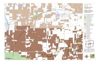
Figure 4-2. Land Use Programs

  • 1. ! !!!!!!!!!! ! ! ! ! ! ! ! ! ! ! ! ! ! ! ! ! ! ! ! ! ! ! ! ! ! ! ! ! ! ! ! ! ! ! ! ! ! ! ! ! ! ! ! ! ! ! ! ! ! ! ! ! ! ! ! ! ! ! ! ! ! ! ! ! ! ! ! ! ! ! ! ! ! ! ! ! ! ! ! ! ! ! ! ! ! ! ! ! ! ! #* #* &=! &=! &=! &=! &=! &=! &=! &=! &=! &=! &=! &=! &=! &=! &=! &=! &=! &=! &=! &=! &=! &=! &=! &=! &=! &=! &=! &=! Albion Reservoir NO 1 Glenwood Lake Albion Reservoir NO 2 Erie Canal Pond Lake Otter Pond Marsh Creek HamiltonSt CR30 State St Bank St OrientSt CR21 Maple St CR25 Gray Rd Washington St C R 15 GwinnSt CR35 CR 25B Allen Rd CR44 CR18 CR45 CR72 WestAve Telegraph Rd PineHillRd CulvertRd CR8 CR 69 CR5 CR45B CR28 CR 98 Oak Orchard State Wildlife Management Area UV31 UV31E UV279 UV98 UV104 UV63 UV31A Iroquois National Wildlife Refuge Albion State Correctional Facility Oak Orchard Creek OakOr chard Creek OakO rch ard Creek 0 0.5 10.25 Miles www.edrdpc.com µ Notes: 1. Basemap: ESRI Street Map North America, 2008. 2. This map was generated in ArcMap on February 12, 2020. 3. This is a color graphic. Reproduction in grayscale may Heritage Wind Project Town of Barre, Orleans County, New York Figure 4-2: Land Use Programs and Specially Designated Areas 1:62,500 ! ! ! ! ! ! ! ! !! ! !! ! ! ! ! ! ! ! Sheet 1 of 4 Nationwide Rivers Inventory Conservation Easement Municipality-owned Land State-owned Land Private-owned Land State Non-Recreation State Recreation Federal Recreation Orleans County Ag District 2 Orleans County Ag District 3 Project Components: &=! Wind Turbine #* Permanent Met Tower Collection Line Access Road Collection Substation POI Substation Laydown Yard O&M Building Facility Site ! ! ! ! 5-mile Study Area
  • 2. ! ! ! ! ! ! ! ! ! ! ! ! ! ! ! ! ! ! !!!!!!!!!!!! ! ! ! ! ! ! ! ! ! ! ! ! ! ! ! ! ! ! ! ! ! ! ! ! ! ! ! ! ! ! ! ! ! ! ! ! ! ! ! ! ! ! ! ! ! ! ! ! ! ! ! ! ! ! ! ! ! ! ! ! ! ! ! ! ! ! ! ! ! ! #* #* &=! &=! &=! &=! &=! &=! &=! &=! &=! &=! &=! &=! &=! &=! &=! &=! &=! &=! &=! &=! &=! &=! &=! Albion Reservoir NO 1 Albion Reservoir NO 2 Erie Canal MC Cargo Lake Otter Pond Erie Lake Pond Marsh Creek HamiltonSt State St Bank St Washington St CR 25B Allen Rd CR 98 CR 69 UV104 UV237 UV31 UV279 UV387 UV31A UV272 UV98 Albion State Correctional Facility 0 0.5 10.25 Miles www.edrdpc.com µ Notes: 1. Basemap: ESRI Street Map North America, 2008. 2. This map was generated in ArcMap on February 12, 2020. 3. This is a color graphic. Reproduction in grayscale may Heritage Wind Project Town of Barre, Orleans County, New York Figure 4-2: Land Use Programs and Specially Designated Areas 1:62,500 ! ! ! ! ! ! ! ! !! ! !! ! ! ! ! ! ! ! Sheet 2 of 4 Conservation Easement Municipality-owned Land State-owned Land Private-owned Land State Non-Recreation Orleans County Ag District 1 Orleans County Ag District 2 Orleans County Ag District 3 Project Components: &=! Wind Turbine #* Permanent Met Tower Collection Line Access Road Collection Substation POI Substation Laydown Yard O&M Building Facility Site ! ! ! ! 5-mile Study Area
  • 3. ! ! ! ! ! ! ! ! ! ! ! ! ! ! ! ! ! ! ! ! ! ! !!!! ! ! ! ! ! ! ! ! ! ! ! !!!!!!!!!!!!!! ! ! ! ! ! ! ! ! ! ! ! ! ! ! ! ! ! ! ! ! ! ! ! ! ! ! ! ! ! ! ! ! ! ! !!!!!!!!!! ! ! ! ! ! ! ! ! ! ! ! ! ! #* &=! &=! &=! &=! &=! &=! &=! &=! &=! &=! &=! &=! &=! &=! &=! &=! &=! &=! &=! &=! &=! &=! &=! &=! &=! &=! &=! Lake Oak Orchard Creek Phelps Pond Pond CR9 CR25 Gray Rd CR 25B CR18 C R 15 PineHillRd CR 12 CR5 C R 24 CR28 FisherRd CR 23 C R 98 Oak Orchard State Wildlife Management Area John White Memorial State Game Farm UV262 UV77 UV63 UV98 Iroquois National Wildlife Refuge Oak OrchardCr eek OakOrchardCr eek Oak Orchard Creek 0 0.5 10.25 Miles www.edrdpc.com µ Notes: 1. Basemap: ESRI Street Map North America, 2008. 2. This map was generated in ArcMap on February 12, 2020. 3. This is a color graphic. Reproduction in grayscale may Heritage Wind Project Town of Barre, Orleans County, New York Figure 4-2: Land Use Programs and Specially Designated Areas 1:62,500 ! ! ! ! ! ! ! ! !! ! !! ! ! ! ! ! ! ! Sheet 3 of 4 Nationwide Rivers Inventory 480a - Forest Tax Law Parcel Conservation Easement Municipality-owned Land State-owned Land State Recreation Federal Recreation Orleans County Ag District 2 Genesee County Ag District 12 Genesee County Ag District 2 Project Components: &=! Wind Turbine #* Permanent Met Tower Collection Line Access Road Collection Substation POI Substation Laydown Yard O&M Building Facility Site ! ! ! ! 5-mile Study Area
  • 4. !!!!!! ! ! ! ! ! ! ! ! ! ! ! ! ! ! ! ! ! ! ! ! ! ! ! ! ! ! ! ! ! ! ! ! ! ! ! ! ! ! ! ! ! ! ! ! ! ! ! ! ! ! ! ! ! ! ! ! !!!! ! ! ! ! ! ! ! ! ! ! ! !!!!!!!!!!!!! #* #* &=! &=! &=! &=! &=! &=! &=! &=! &=! &=! &=! &=! &=! &=! &=! &=! &=! &=! &=! &=! &=! &=! &=! &=! &=! &=! &=! Pond C R 15 CR45B CR25 CR 25B CR 12 CR5 FisherRd CR 69 C R 24 C R 98 UV63 UV31A UV33 UV237 UV262 UV98 Black Creek Oak Orchard Creek 0 0.5 10.25 Miles www.edrdpc.com µ Notes: 1. Basemap: ESRI Street Map North America, 2008. 2. This map was generated in ArcMap on February 12, 2020. 3. This is a color graphic. Reproduction in grayscale may Heritage Wind Project Town of Barre, Orleans County, New York Figure 4-2: Land Use Programs and Specially Designated Areas 1:62,500 ! ! ! ! ! ! ! ! !! ! !! ! ! ! ! ! ! ! Sheet 4 of 4 Nationwide Rivers Inventory 480a - Forest Tax Law Parcel Conservation Easement Municipality-owned Land Orleans County Ag District 2 Genesee County Ag District 12 Genesee County Ag District 2 Project Components: &=! Wind Turbine #* Permanent Met Tower Collection Line Access Road Collection Substation POI Substation Laydown Yard O&M Building Facility Site ! ! ! ! 5-mile Study Area