
Recommended
More Related Content
Similar to Figure 22-3. Delineated Wetlands and Surface Waters
Similar to Figure 22-3. Delineated Wetlands and Surface Waters (9)
More from Heritage Wind
More from Heritage Wind (20)
Recently uploaded
Recently uploaded (20)
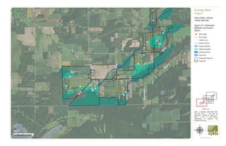
Figure 22-3. Delineated Wetlands and Surface Waters
- 1. CR25 C R 15 DrakeIslandRd HillRd R oot R d G illette R d CR99 T1 T2 T3 T4 T5 T6 T7 T8 1M 1P 1E 1G 1C 1O 1B 1D 1H 1J 1K 1A 1L 1I 3Q 1N 1F 0 0.25 0.50.125 Miles www.edrdpc.com µ Notes: 1. Basemap: USDA NAIP "2019 New York 0.5m". 2. This map was generated in ArcMap on February 12, 2020. 3. This is a color graphic. Reproduction in grayscale may misrepresent the data. Heritage Wind Project Town of Barre, Orleans County, New York Figure 22-3: Delineated Wetlands and Surface Waters &=! Wind Turbine Access Road Collection Line Predicted Stream Predicted Wetland Delineated Wetland Delineated Stream Vernal Pool Delineation Study Area Facility Site Sheet 1 of 3 1:24,000
- 2. R oot R d G illette R d T7 T8 T9 T10 T11 T12 T13 T14 T15 T16 T17 T18 T19 T20 T21 T22 T23 T24 T25 T26 T27 T28 1M 1P 1H 1O 2I 3F 3E 2A 2Q 3K 1X 3O 4B 4C 4A 2W 4E 4F4D 2N 1V 1W 1Y 2R 1Z 2U 2P 2S 2V 2Z 2X 1U 1J 1K 3C 2C 1S 1Q 3B 3D 2Y 3A3N 2E 2F 2H 2J 1L 2D 2G 2T 2B 2K 2O 2M 1T 1R 3P 3Q 3S 3T 2L 3U 1N 0 0.25 0.50.125 Miles www.edrdpc.com µ Notes: 1. Basemap: USDA NAIP "2019 New York 0.5m". 2. This map was generated in ArcMap on February 12, 2020. 3. This is a color graphic. Reproduction in grayscale may misrepresent the data. Heritage Wind Project Town of Barre, Orleans County, New York Figure 22-3: Delineated Wetlands and Surface Waters &=! Wind Turbine #* Permanent Met Tower Access Road Collection Line Transmission Line Predicted Stream POI Substation Collection Substation O&M Facility Laydown Area and Batch Plant Predicted Wetland Delineated Wetland Delineated Stream Vernal Pool Delineation Study Area Facility Site Sheet 2 of 3 1:24,000
- 3. T14 T15 T17 T20 T22 T23 T24 T25 T26 T27 T28 T29 T30 T31 T32 T33 2O 2P 3F 3E 2V 2U 2Z 1W 3I 3K 3L 3N 1X 2W 3H 3J 3G 3M 2X 3C 2C 3B 3D 2Y 3A 2E 2F 2H 2I 2J 2D 2G 2B 3P0 0.25 0.50.125 Miles www.edrdpc.com µ Notes: 1. Basemap: USDA NAIP "2019 New York 0.5m". 2. This map was generated in ArcMap on February 12, 2020. 3. This is a color graphic. Reproduction in grayscale may misrepresent the data. Heritage Wind Project Town of Barre, Orleans County, New York Figure 22-3: Delineated Wetlands and Surface Waters &=! Wind Turbine #* Permanent Met Tower Access Road Collection Line Predicted Stream Laydown Area and Batch Plant Predicted Wetland Delineated Wetland Delineated Stream Vernal Pool Delineation Study Area Facility Site Sheet 3 of 3 1:24,000