1. &=!
&=!
&=!
&=!
&=!
&=!
&=!
&=!
Genesee County
Orleans County
Town of Barre
Town of ElbaTown of
Oakfield
UV98
AnA
AnA
AnA
AnA
AnA
AnA
AnA
AnA
AnA
AnA
AnA
AnA AnB
Ba
BoB
Ca
Ca
Ca
Ca
Ca
Ca Ca
Ca
CcB
CcB
ChA
ChA
ChA
ChA
ChA
ChA
ChA
ChA
ChA
ChA
ChA
ChA
ChA
ChA
ChA
ChA
ChA
ChA
CmB
Fo
Fo
Fo
HbA
HbA
HbA
HbA
HbB
HbB
HbB
HbB
HbB
HbB
HbB
HbB
HbB
HbB
HbB
HbB
HbB
HbB
HbB
HbB
HbB
HbB
HbB
HbB
HbB
HbB
Lk
Lk
Lk
Lk
Lk
Lk
Lk
Lk
Lk
Lk
Lk
Lk
Lk
Lk
Lk
Lk
Ly
Ly
Ly
Ly
Ma
NgA
OdA
OdA
OdA
OdA
OdA
OdA
OdA
OdA
OdA
OdA
OdA
OdB
OnB
OnB OnB
OnB OnB
OnB
OnC
OnC
OnC
OnC
OvA
OvA
Pm
Pm
WmB
W
WW W
W
T1
T2
T3
T4
T5
T6
T7
T8
0 2,000 4,0001,000
Feet
www.edrdpc.com
µ
Notes: 1. Basemap: ESRI StreetMap North
America, 2008 and hillshade derived from
USGS 1-meter DEM data. 2. This map
was generated in ArcMap on February 12,
2020. 3. This is a color graphic.
Reproduction in grayscale may
misrepresent the data. 4. Soil type
classifications listed on Table 21-1.
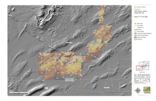
Heritage Wind
Project
Town of Barre, Orleans
County, New York
Figure 21-2: Soil Types
&=!
Wind Turbine
Access Road
Collection Line
Facility Site Soils
Prime Farmland
Farmland of Statewide Importance
Prime Farmland If Drained
Not Prime Farmland
Facility Site
1:24,000
Sheet 1 of 4
2. #*
#*
&=!
&=!
&=!
&=!
&=!
&=!
&=!
&=!
&=!
&=!
&=!
Town of
Albion
Town of Barre
UV31A
UV98
AnA
AnA
AnA
AnA
AnA
AnA
AnA
AnA
AnA
AnA
AnA
AnA
AnA
AnA AnA
AnA
AnA
AnAAnA
AnA
AnA
AnA
AnA
AnA
AnA
AnA
AnA
AnA
AnA
AnA
AnA
AnA
AnA
AnB
AnB
AnB
AnB
Ba
Ba
BoB
BoB
Ca
Ca
Ca
Ca
Ca
Ca
Ca
ChA
ChA
ChA ChA
ChA
ChA
ChA
ElB
Fo
GaB
GaB
HbA
HbA HbA
HbA
HbA
HbA
HbA
HbA
HbA
HbB
HbB
HbB
HbB
HbB
HbB
HbB
HbB
HbB
HbB
HbB
HbB
HbB
HbB
HbB
HbB
HbB HbB
HbB
HbB
HbB
HbB
HbB
HbB
HbB
HbB
HbB
HbB
HbB
HbB
HbB
HbB
HbB
HpC
Lk
Lk
Lk
Lk
Lk
Lk
Lk
Ln
Ly
Ly
Ly
Ly
Ly
Ly
Ly
Ly
Ly
Ly
Ly
Ly
Ly
Ly
Ly
OdA
OdA
OdA
OdA
OnB
OnB
OnB
OnB
OnC
OnC
OvA
OvA
OvA
Pm
Pm
Su
SuW
MET-1
T8
T9
T10
T11
T12
T13
T14
T15
T17
T20
T22
0 2,000 4,0001,000
Feet
www.edrdpc.com
µ
Notes: 1. Basemap: ESRI StreetMap North
America, 2008 and hillshade derived from
USGS 1-meter DEM data. 2. This map
was generated in ArcMap on February 12,
2020. 3. This is a color graphic.
Reproduction in grayscale may
misrepresent the data. 4. Soil type
classifications listed on Table 21-1.
Heritage Wind
Project
Town of Barre, Orleans
County, New York
Figure 21-2: Soil Types
&=!
Wind Turbine
#* Permanent Met Tower
Access Road
Collection Line
POI Substation
Collection Substation
O&M Facility
Laydown Yard
Facility Site Soils
Prime Farmland
Farmland of Statewide Importance
Prime Farmland If Drained
Not Prime Farmland
Facility Site
1:24,000
Sheet 2 of 4
3. #*
&=!
&=!
&=!
&=!
&=!
&=!
&=!
&=!
&=!
&=!
&=!
&=!
&=!
&=!
&=!
&=!
Town of
Albion
Town of Barre
Town of
Clarendon
Town of
Murray
UV98
UV31A
AnA
AnA
AnA
AnA
AnA
AnA
AnA
AnA
AnA
AnA AnA
AnA
AnA
AnA
AnA
AnA
AnA
AnA
AnA
AnA
AnA
AnA
AnA
AnA
AnA
AnA
AnA
AnA
AnB
AnB
AnB
AnB
AnB
AnB
AnB
Ba
Ba
Ba
BoB
BoB
Ca
Ca
Ca
Ca
Ca
Ca
Ca
Ca
Ca
CeB
CeB
CeB
CeB
CeB
ChA
ChA
ChA
ChA
ChA
ChA
ChA
ChA
ChA
Fo
GaB
GaB
HnB
HnB
HnB
HnB
HnB
HnB
HnB
HnB
HnB
HnB
HnB
HnB
HbA
HbA
HbA
HbA
HbAHbB
HbB
HbB
HbB
HbB
HbB
HbB
HbB
HbB
HbB
HbB
HbB
HbB
HbB
HbB
HbB
HbB
HbB
HbB
HbB
HbB HbB
HbB
HbB
HbB
HbB
HbB
HbB
HbB
HbB
HbB
HbB
HbB
HbB
HbB
HbB
HcA
HcB
HcB
HpC
KaA
KaA
Lk
Lk
Ln
Ly
Ly
Ly
Ly
Ly
Ly
Ly
Ly
Ly
Ly
Ly
Ly
Ly
Ly
Ly
Lz
MdB
MdB
NgA
NgA
OnB
OnB
OnB
OnB
OnB
OnB
OnB
OnC
OnC
OnC
OnC
OoB OoB
OoB
OoB
OoB
OoB
OoB
OoB
OoB
OoB
OoB
OoB
OoB
OoB
OoB
OoB
OsC
OvA
Pm
Pm
Pm
Pm
Pm
Su
SuW
MET-2
T14
T15
T17
T20
T22
T23
T24
T25
T26
T27
T28
T29
T30
T31
T32
T33
0 2,000 4,0001,000
Feet
www.edrdpc.com
µ
Notes: 1. Basemap: ESRI StreetMap North
America, 2008 and hillshade derived from
USGS 1-meter DEM data. 2. This map
was generated in ArcMap on February 12,
2020. 3. This is a color graphic.
Reproduction in grayscale may
misrepresent the data. 4. Soil type
classifications listed on Table 21-1.
Heritage Wind
Project
Town of Barre, Orleans
County, New York
Figure 21-2: Soil Types
&=!
Wind Turbine
#* Permanent Met Tower
Access Road
Collection Line
Laydown Yard
Facility Site Soils
Prime Farmland
Farmland of Statewide Importance
Prime Farmland If Drained
Not Prime Farmland
Facility Site
1:24,000
Sheet 3 of 4
4. &=!
&=!
&=!
&=!
&=!
&=!
&=!
&=!
&=!
&=!
&=!
&=!
&=!
&=!
&=!
&=!
Genesee County
Orleans County
Town of Barre
Town of Byron
Town of
Clarendon
Town of Elba
UV98
AnA
AnA
AnA
AnA
AnA
AnA
AnA
AnA
AnA
AnA
AnA
AnA
AnA
AnA
AnA
AnA
AnA
AnA
AnA
AnA
AnA
AnA AnA
AnA
AnA
AnA
AnA
AnA
AnA
AnA
AnA
AnA
AnA
AnA
AnA
AnA
AnA
AnA
AnA
AnA
AnA
AnA
AnA
AnA
AnB
AnB
AnB
AnB
AnB
AnB
Ba
Ba
Ba
Ba
Ba
Bg
Bg
Bg
Bg
Bg
BoB
BoB
Ca
Ca
Ca
Ca
Ca
Ca
Ca
Ca
Ca
Ca
ChA
ChA
ChA
ChA
ChA
ChA
ChA
ChA
ChA
FoFo
Fo
Fo
Fo
Fo
GaB
GaB
HbA
HbA
HbA
HbA
HbA
HbA
HbA
HbA
HbA
HbA
HbA
HbA
HbB
HbB
HbB
HbB
HbB
HbB
HbB
HbB
HbB
HbB
HbB
HbB
HbB
HbB
HbB
HbB
HbB
HbB
HbB
HbB
HbB
HbB
HbB
HbB
HbB
HbB
HbB
HbB HbB
HbB
HbB
HbB
HbB
HbB
HbB
HbB
HbB
HbB
HbB
HbB
HbB
HbB
HbB
HbB
HbB
HbB
HbB
HbB
HbB
HbB
HbB
HbB
HpC
Lk
Lk
Lk
Lk
Lk
Lk
Lk
Lk
Ln
Ly
Ly
Ly
Ly
Ly
Ly
Ly
Ly
Ly
Ly
Ly
Ly
Ly
Ly
OdA
OdA
OnB
OnB
OnB
OnB
OnB
OnB
OnB
OnC
OnCOvA
Pm
Pm
Pm
Pm
Pm
Pm
Su
Su
Su
Su
W
T12
T13
T14
T15
T16
T17
T18
T19
T20
T21
T23
T25
T26
T27
0 2,000 4,0001,000
Feet
www.edrdpc.com
µ
Notes: 1. Basemap: ESRI StreetMap North
America, 2008 and hillshade derived from
USGS 1-meter DEM data. 2. This map
was generated in ArcMap on February 12,
2020. 3. This is a color graphic.
Reproduction in grayscale may
misrepresent the data. 4. Soil type
classifications listed on Table 21-1.
Heritage Wind
Project
Town of Barre, Orleans
County, New York
Figure 21-2: Soil Types
&=!
Wind Turbine
Access Road
Collection Line
POI Substation
Collection Substation
O&M Facility
Laydown Yard
Facility Site Soils
Prime Farmland
Farmland of Statewide Importance
Prime Farmland If Drained
Not Prime Farmland
Facility Site
1:24,000
Sheet 4 of 4