1. !!!!!!
!
!
!
!
!
!
!
!
!
!
!
!
!
!
!
!
!
!
!
!
!
!
!
!
!
!
!
!
!
!
!
!
!
!
!
!
!
!
!
!
!
!
!
!
!
!
!
!
!
!
!
!
!
!
!
!
!
!
!
!
!
!
!
! ! ! ! ! ! ! ! !
!
!
!
!
!
#*
#*
&=!
&=!
&=!
&=!
&=!
&=!
&=!
&=!
&=!
&=!
&=!
&=!
&=!
&=!
&=!
Albion
Marsh Creek
Otter Creek
Erie
Canal
W Branch Sandy Creek
Fish
Cr
eek
Otter Pond
Albion
Reservoir
NO 1
Albion
Reservoir
NO 2
CulvertRd
W Bank St
Telegraph Rd
Maple St
OakOrchardRd
EShelbyRd
NMainSt
W State St
SMainSt
Washington St
E Bank St
HamiltonSt
Allen Rd
West Ave East Ave
EagleHarborRd
PineHillRd
CR5
E Barre Rd
Million Dollar Hwy
QuakerHillRd
Maple Ridge Rd
W Lee Rd
Gray Rd
E Lee Rd
ST31
ST98
ST31A
Town of
Albion
Town of Barre
Town of
Gaines
Town of
Ridgeway
Town of
Shelby
0 0.5 10.25
Miles
www.edrdpc.com
µ
Notes: 1. Basemap: ESRI Street Map North
America, 2008. 2. This map was generated in
ArcMap on February 12, 2020. 3. This is a
color graphic. Reproduction in grayscale may
misrepresent the data.
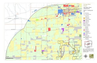
Heritage Wind
Project
Town of Barre, Orleans
County, New York
Figure 4-1: Existing Land
Use
1:50,000
Sheet 1 of 4
&=!
Wind Turbine
#* Permanent Met Tower
Access Road
Collection Line
POI Substation
Collection Substation
O&M Building
Laydown Yard
Facility Site
!
!
!
! 5-mile Study Area
NYSORPS Classification:
Agricultural
Residential
Vacant Land
Commercial
Recreation and
Entertainment
Community Services
Industrial
Public Services
Wild, Forested,
Conservation Lands and
Public Parks
Uncategorized
2. !
!
!
!
!
!
!
!
!
!
!
!
!
!
!
!
!
!
!
!
!
!
!!!!!!!!!!!!!!!
!
!
!
!
!
!
!
!
!
! ! ! ! ! ! ! ! ! !
!
!
!
!
!
!
!
!
!
!
!
!
!
!
!
!
!
!
!
!
!
!
! ! ! ! ! ! ! ! ! ! ! !
!
!
!
!
!
!
!
!
!
!
!
!
!
!
!
!
!
!
#*
#*
&=!
&=!
&=!
&=! &=!
&=!
&=!
&=!
&=!
&=!
&=!
&=!
&=!
&=!
&=!
&=!
&=!
&=!
&=!
Albion
Holley
ManningMucklandCreek
BeardsleyCreek
SandyCreek
Marsh Creek
E
Branch Sandy Creek
W Branch Sandy Creek
Erie Canal
Erie Lake
MC Cargo Lake
W Bank St
E Barre Rd
NMainSt
W State St
SMainSt
Washington St
E Bank St
HamiltonSt
W Albion St
Allen Rd
West Ave East Ave
E Lee Rd
4Th Section Rd
State St
OakOrchardRd
FancherRd
NMainStreetRd
Holley Byron
Rd
W Lee Rd
KendallRd
GainesRd
ST237
ST31
ST31A
ST104
ST387
ST279
ST98
Town of
Albion
Town of Barre
Town of
Clarendon
Town of
Gaines
Town of
Murray
0 0.5 10.25
Miles
www.edrdpc.com
µ
Notes: 1. Basemap: ESRI Street Map North
America, 2008. 2. This map was generated in
ArcMap on February 12, 2020. 3. This is a
color graphic. Reproduction in grayscale may
misrepresent the data.
Heritage Wind
Project
Town of Barre, Orleans
County, New York
Figure 4-1: Existing Land
Use
1:50,000
Sheet 2 of 4
&=!
Wind Turbine
#* Permanent Met Tower
Access Road
Collection Line
POI Substation
Collection Substation
O&M Building
Laydown Yard
Facility Site
!
!
!
! 5-mile Study Area
NYSORPS Classification:
Agricultural
Residential
Vacant Land
Commercial
Recreation and
Entertainment
Community Services
Industrial
Public Services
Wild, Forested,
Conservation Lands and
Public Parks
Uncategorized
3. !
!
!
!
!
!
!
!
!
!
!
!
!
!
!
!!!!!
!
!
!
!
!
!
!
!
!
!
!
!
!
!
!
!!!!!!!!!!!!!!!!
!
!
!
!
!
!
!
!
!
!
!
!
!
!
!
!
!
!
!
!
!
!
!
!
!
!
!
!
!
!
!
!
!
!
!
!
!
!
!
!
!
!
!!!!!!!!!!!!!
!
!
!
!
!
!
!
!
!
&=!
&=!
&=!
&=!
&=! &=!
&=!
&=!
&=!
&=!
&=!
&=!
&=!
&=!
Elba
Oakfield
ManningMucklandCreek
Fish Creek
BrinningstoolCreek
Oak
Orchard Creek
Schmidt Marsh
Upper
Stafford
Marsh
PineHillRd
Lockport Rd
Lewiston Rd
Knowlesville Rd
EShelbyRd
SMainSt
Drake St
FisherRd
EagleHarborRd
OakOrchardRd
Judge Rd
Ford Rd
Gray Rd
QuakerHillRd
Drake Street Rd
ST63
ST98
ST262
Genesee County
Orleans County
Town of
Alabama
Town of Barre
Town of ElbaTown of
Oakfield
Town of
Shelby
0 0.5 10.25
Miles
www.edrdpc.com
µ
Notes: 1. Basemap: ESRI Street Map North
America, 2008. 2. This map was generated in
ArcMap on February 12, 2020. 3. This is a
color graphic. Reproduction in grayscale may
misrepresent the data.
Heritage Wind
Project
Town of Barre, Orleans
County, New York
Figure 4-1: Existing Land
Use
1:50,000
Sheet 3 of 4
&=!
Wind Turbine
#* Permanent Met Tower
Access Road
Collection Line
POI Substation
Collection Substation
O&M Building
Laydown Yard
Facility Site
!
!
!
! 5-mile Study Area
NYSORPS Classification:
Agricultural
Residential
Vacant Land
Commercial
Recreation and
Entertainment
Community Services
Industrial
Public Services
Wild, Forested,
Conservation Lands and
Public Parks
Uncategorized
4. !
!
!
!
!
!
!
!
!
!
!
!
!
!
!
!
!
!
!
!
!
!
!
!
!
!
!
!
!
!
!
!
!
!
!
!
!
!
!
!
!
!
!
!
!
!
!
!
!
!
!
!
!
!
!
!
!
!
!
!
!
!
!
!
!
!
!
!
!
!
!
!!!!!
!
!
!
!
!
!
!
!
!
!
!
!
!
!
!
!!!!!!
#*
&=!
&=!
&=!
&=!
&=!
&=!
&=!
&=!
&=!
&=!
&=!
&=!
&=!
&=!
&=!
&=!
&=!
Elba
ManningMucklandCreek
EBranchSandyCreek
Spring Creek
Oak Orchard Creek
BlackCreek
Lockport Rd
SMainSt
Oak Orchard Rd
Townline Rd
HolleyByronRdByronHolleyRd
Byron Elba Rd
Ford Rd
QuakerHillRd
Drake Street Rd
ST98
ST262
ST237
Genesee County
Orleans County
Town of Barre
Town of Byron
Town of
Clarendon
Town of Elba
0 0.5 10.25
Miles
www.edrdpc.com
µ
Notes: 1. Basemap: ESRI Street Map North
America, 2008. 2. This map was generated in
ArcMap on February 12, 2020. 3. This is a
color graphic. Reproduction in grayscale may
misrepresent the data.
Heritage Wind
Project
Town of Barre, Orleans
County, New York
Figure 4-1: Existing Land
Use
1:50,000
Sheet 4 of 4
&=!
Wind Turbine
#* Permanent Met Tower
Access Road
Collection Line
POI Substation
Collection Substation
O&M Building
Laydown Yard
Facility Site
!
!
!
! 5-mile Study Area
NYSORPS Classification:
Agricultural
Residential
Vacant Land
Commercial
Recreation and
Entertainment
Community Services
Industrial
Public Services
Wild, Forested,
Conservation Lands and
Public Parks
Uncategorized