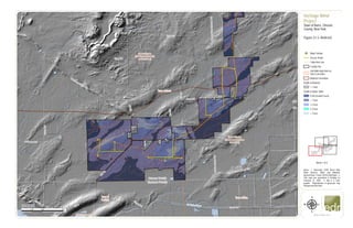
1. &=!
&=!
&=!
&=!
&=!
&=!
&=!
&=!
Genesee County
Orleans County
Town of Barre
Town of ElbaTown of
Oakfield
UV98
Oak Orchard Creek
Muck Rd
Drake Island Road Ext
Johnson Rd
BraggSchoolhouseRd
DrakeIslandRd
HillRd
CR 9
Root Rd
CR
22
Allis Rd
G
illette
R
d
CR99
Hemlock Ridge Rd
BurnsRd
CR25
Gray Rd
PineHillRd
C
R
15
Fisher Rd
CR5
UV98
Upper Silurian
(dolostone (dolomite)
and limestone)
Upper Silurian
(shale and dolostone
(dolomite))
Holocene (water and )
0 2,000 4,0001,000
Feet
www.edrdpc.com
µ
Notes: 1. Basemap: ESRI Street Map
North America, 2008. and hillshade
deroved from 1 meter USGS DEM data. 2.
This map was generated in ArcMap on
February 12, 2020. 3. This is a color
graphic. Reproduction in grayscale may
misrepresent the data.
Heritage Wind
Project
Town of Barre, Orleans
County, New York
Figure 21-3: Bedrock
&=!
Wind Turbine
Access Road
Collection Line
Facility Site
Soil With High Risk for
Steel Corrosion
Bedrock Formation
Depth to Bedrock
< 1 foot
Depth to Water Table
0 (At Ground Level)
< 1 foot
1-2 feet
2-3 feet
> 3 feet
1:24,000
Sheet 1 of 4
2. #*
#*
&=!
&=!
&=!
&=!
&=!
&=!
&=!
&=!
&=!
&=!
&=!
Town of
Albion
Town of Barre
UV31A
UV98
W
BranchSandyCreek
Puzzey Rd
Barre Rd
GainesBasinRd
Lime Kiln Rd
Miller Rd
C
ushing
R
d
BraggSchoolhouseRd
CulverRd
Maple St
Allis Rd
JohnnyCakeLn
CR 99
CR 36B
CR 25B
CR 69
CR 98
UV31A
UV98
Lower Silurian
(shale and dolostone
(dolomite))
Upper Silurian
(dolostone (dolomite)
and limestone)
Upper Silurian
(shale and dolostone
(dolomite))
0 2,000 4,0001,000
Feet
www.edrdpc.com
µ
Notes: 1. Basemap: ESRI Street Map
North America, 2008. and hillshade
deroved from 1 meter USGS DEM data. 2.
This map was generated in ArcMap on
February 12, 2020. 3. This is a color
graphic. Reproduction in grayscale may
misrepresent the data.
Heritage Wind
Project
Town of Barre, Orleans
County, New York
Figure 21-3: Bedrock
&=!
Wind Turbine
#* Permanent Met Tower
Access Road
Collection Line
POI Substation
Collection Substation
O&M Facility
Laydown Yard
Facility Site
Soil With High Risk for
Steel Corrosion
Bedrock Formation
Depth to Bedrock
< 1 foot
Depth to Water Table
0 (At Ground Level)
< 1 foot
1-2 feet
> 3 feet
1:24,000
Sheet 2 of 4
3. #*
&=!
&=!
&=!
&=!
&=!
&=!
&=!
&=!
&=!
&=!
&=!
&=!
&=!
&=!
&=!
&=!
Town of
Albion
Town of Barre
Town of
Clarendon
Town of
Murray
UV98
UV31A
ManningMucklandCreek
WBranchSandyCreek
CR 36A
CR 56
Maple St
CR30A
YahnkeRd
LewisRd
CR 99 Barre Rd
CR91
RockRd
TransitRd
MathesRd
Thorpe Rd
Lime Kiln Rd
Mansfield Rd
Brown Schoolhouse Rd
Mcnamar Rd
C
ushing
R
d
County House Rd
AngevineRd
Powerline Rd
CR83
CulverRd
CR 36B
CR 25B
CR
98
CR 69
UV98
UV31A
Lower Silurian
(shale and dolostone
(dolomite))
Upper Silurian
(dolostone (dolomite)
and limestone)
Upper Silurian
(shale and dolostone
(dolomite))
0 2,000 4,0001,000
Feet
www.edrdpc.com
µ
Notes: 1. Basemap: ESRI Street Map
North America, 2008. and hillshade
deroved from 1 meter USGS DEM data. 2.
This map was generated in ArcMap on
February 12, 2020. 3. This is a color
graphic. Reproduction in grayscale may
misrepresent the data.
Heritage Wind
Project
Town of Barre, Orleans
County, New York
Figure 21-3: Bedrock
&=!
Wind Turbine
#* Permanent Met Tower
Access Road
Collection Line
Laydown Yard
Facility Site
Soil With High Risk for
Steel Corrosion
Bedrock Formation
Depth to Bedrock
< 1 foot
> 3 feet
Depth to Water Table
0 (At Ground Level)
< 1 foot
1-2 feet
2-3 feet
> 3 feet
1:24,000
Sheet 3 of 4
4. &=!
&=!
&=!
&=!
&=!
&=!
&=!
&=!
&=!
&=!
&=!
&=!
&=!
&=!
&=!
&=!
Genesee County
Orleans County
Town of Barre
Town of Byron
Town of
Clarendon
Town of Elba
UV98
Manning Muckland Creek
Barre Rd
YahnkeRd
TownLineRd
CR 99
RootIsland
Rd
Gillette Rd
Spoil Bank Rd
Root Rd
Hundredm
arkRd
New Guinea Rd
Mansfield Rd
Brown Schoolhouse Rd
Mcnamar Rd
Cushing
Rd
Puzzey Rd
CulverRd
Sheelar Rd
Delano Steele Rd
TransitRd
AngevineRd
CR24
CR98
UV98
Upper Silurian
(dolostone (dolomite)
and limestone)
Upper Silurian
(shale and dolostone
(dolomite))
0 2,000 4,0001,000
Feet
www.edrdpc.com
µ
Notes: 1. Basemap: ESRI Street Map
North America, 2008. and hillshade
deroved from 1 meter USGS DEM data. 2.
This map was generated in ArcMap on
February 12, 2020. 3. This is a color
graphic. Reproduction in grayscale may
misrepresent the data.
Heritage Wind
Project
Town of Barre, Orleans
County, New York
Figure 21-3: Bedrock
&=!
Wind Turbine
Access Road
Collection Line
POI Substation
Collection Substation
O&M Facility
Laydown Yard
Facility Site
Soil With High Risk for
Steel Corrosion
Bedrock Formation
Depth to Bedrock
< 1 foot
Depth to Water Table
0 (At Ground Level)
< 1 foot
1-2 feet
> 3 feet
1:24,000
Sheet 4 of 4