Remote sensing - Sensors, Platforms and Satellite orbits
•
9 likes•5,388 views

Remote sensing Sensors, Platforms and Satellite orbits

Recommended
More Related Content
What's hot
What's hot (20)
Similar to Remote sensing - Sensors, Platforms and Satellite orbits
Similar to Remote sensing - Sensors, Platforms and Satellite orbits (20)
More from Ajay Singh Lodhi
More from Ajay Singh Lodhi (20)
Recently uploaded
Recently uploaded (20)
Remote sensing - Sensors, Platforms and Satellite orbits
- 1. REMOTE SENSING – SENSORS, PLATFORMS AND SATELLITE ORBITS Dr. Ajay Singh Lodhi Assistant Professor College of Agriculture, Balaghat Jawahar Lal Krishi Vishwa Vidyalaya, Jabalpur (M.P.)
- 2. Remote Sensing Sensors Sensor is an electronic circuit which can record the electromagnetic radiation incident upon it. A sensor is a device comprising of optical component or system and a detector with electronic circuit. It senses a variation in input energy to produce a variation in another or same form of energy. All sensors employed on earth observation platforms use electromagnetic radiation to observe terrain features. Various types of sensor are employed based on requirements and purpose. Remote sensing sensors measure radiance of objects under study in a given wavelength. Sensors comprise of several components such as- System to receive radiation from the pixel and a telescope (objective), Calibration source and spectrometer, Amplifier and recording system,
- 3. Classification of Remote Sensing Sensors Remote sensors can be broadly classified as passive sensors and active sensors. Sensors which sense natural radiation, either emitted or reflected from the earth are called passive sensors. This process is known as passive remote sensing. It is also possible to produce electromagnetic radiation of a specific wavelength or band of wavelengths as a part of the sensor system. The interaction of this radiation with the target could then be studied by sensing the scattered radiation from the targets. Such sensors, which produce their own electromagnetic radiation, are called active sensors. This process of remote sensing is active remote sensing.
- 4. Sensors Characteristics Sensor Parameters and Resolution The information collected by the remote sensors is meant to identify and map various earth surface objects. Therefore, we may say that the performance of the sensor is evaluated based on its classification as well as its mapping accuracy requirements. It is reasonable to assume that this will depend on the instruments ability to detect small differences in the emittance/ reflectance of the earth’s surface in a number of spectral bands for as small an object as possible and as often as possible. We may consider the sensor parameters under four domains: (1) Spatial (2) Spectral (3) Radiometric (4) Temporal.
- 5. Resolution Resolution is defined as a measure of sensor ability to distinguish between signals. All remote sensing information is resolution dependent. The various parameters which characterize theses different kinds of sensor systems are described by resolution. The quality of remote sensing data depends on its spatial, spectral, radiometric and temporal resolution. Spatial resolution refers to the size of the smallest object that can be detected in an image. The basic unit in an image is called a pixel. One-meter spatial resolution means each pixel image represents an area of one square meter in the ground. Spectral resolution refers to the number of bands and the wavelength width of each band. A band is a narrow portion of the electromagnetic spectrum. Shorter wavelength widths can be distinguished in higher spectral resolution images.
- 6. Radiometric resolution refers to the sensitivity of a remote sensor to variations in the reflectance levels. The higher the radiometric resolution of a remote sensor, the more sensitive it is to detecting small differences in reflectance values. Higher radiometric resolution allows a remote sensor to provide a more precise picture of a specific portion of the electromagnetic spectrum. Radiometric resolution is expressed in bits. Temporal resolution refers to how often a remote sensing platform can provide coverage of an area. Geo-stationary satellites can provide continuous sensing while normal orbiting satellites can only provide data each time they pass over an area.
- 7. SENSORS Optical-Infrared Sensors Optical infrared remote sensors are used to record reflected/emitted radiation of visible, near-middle and far infrared regions of electromagnetic radiation. They can observe for wavelength extend from 400-2000 nm. Sun is the source of optical remote sensing. There are two kinds of observation methods using optical sensors: Visible/near infrared remote sensing and Thermal infrared remote sensing.
- 8. Visible/Near Infrared Remote Sensing In this observation method visible light and near infrared rays of sunlight reflected by objects on the ground is observed. The magnitude of reflection infer the conditions of land surface, e.g., plant species and their distribution, forest farm fields, rivers, lakes, urban areas etc. In the absence of sunlight or darkness, this method cannot be used. Thermal Infrared Remote Sensing In thermal infrared remote sensing, the land surface radiate heat due to interaction of earth surface with solar radiation. Also this is used to observe the high temperature areas, such as volcanic activities and forest fires. Based on the strength of radiation, one can surface temperatures of land and sea, and status of volcanic activities and forest fires. This method can observe at night when there is no cloud.
- 9. The optical remote sensing can be classified into panchromatic imaging system, multispectral imaging system and hyperspectral imaging system. Panchromatic Imaging System A single channel sensor with broad wavelength range is used to detect radiation within a broad wavelength range. In panchromatic band, visible and near infrared are included. The imagery appears as a black and white photograph. The color of the target is not available. Examples of panchromatic imaging system are Landsat ETM+ PAN, SPOT HRV-PAN and IKONOS PAN, IRS-1C, IRS-1D and CARTOSAT-2A. Spectral range of Panchromatic band of ETM+ is 0.52 µm to 0.9 µm, CARTOSAT-2B is 0.45-0.85 µm, SPOT is 0.45- 0.745 µm.
- 10. Multispectral imaging system The multispectral imaging system uses a multichannel detectors and records radiation within a narrow range of wavelength. Both brightness and color informations are available on the image. LANDSAT, LANDSAT TM, SPOT HRV-XS and LISS etc. are the examples. Hyperspectral imaging system Hyperspectral imaging system records the radiation of terrain in 100s of narrow spectral bands. Therefore the spectral signature of an object can be achieved accurately, helps in object identification more precisely. Example, Hyperion data is recorded in 242 spectral bands, and AVIRIS data is recorded in 224 spectral bands.
- 11. Microwave Sensors The region Microwave sensors receive microwaves, which are longer wavelength than visible light and infrared rays, and observation is not affected by day, night or weather. Microwave portion of the spectrum includes wavelengths within the approximate range of 1 mm to 1m. Thus, the longest microwaves are about 2,500,000 times longer than the shortest light waves. There are two types of observation methods using microwave sensor: active and passive. Active sensor: The sensor emits microwaves and observes microwaves reflected by land surface features. It is used to observe mountains, valleys, surface of oceans wind, wave and ice conditions. Passive sensor: This type of sensor records microwaves that naturally radiated from earth surface features. It is suitable to observe sea surface temperature, snow accumulation, thickness of ice, soil moisture and hydrological applications etc. RISAT is an Indian remote sensing satellite provides microwave data.
- 12. SCANNING MECHANISM Multispectral scanner images are acquired by means of along track or across track scanning system. Depending on the way of scanning, remote sensing scanner can be categorized as: across track (whiskbroom) and along track (push broom) scanning. Across-track scanning Multispectral scanning systems make two dimensional images of terrain for swath beneath the platform. Swath is width of the strip of a scene along the across track direction. Across track scanners scan the earth terrain in a series of lines. The lines are oriented in the direction perpendicular to the motion of the sensor platform (i.e. across the swath). Hence in across track scanning an optical-mechanical scanner (also known as whiskbroom scanner) scans along the swath from one side to another.
- 13. Along-track scanning To achieve better spatial / spectral resolution than those provided by opto- mechanical scanners, push broom imaging systems are currently being used, referred as along track scanning. In along track scanning the detector scans the terrain of earth in the flight direction directly beneath the platform. The detector scans the whole terrain equal to width of swath in a strip or line. To build up a two dimensional image by recording successive scan lines, the detectors are oriented at right angles to the flight direction.
- 14. REMOTE SENSING PLATFORMS Platforms: For remote sensing applications, sensors should be mounted on suitable stable platforms. These platforms can be ground based air borne or space borne based. As the platform height increases the spatial resolution and observational area increases. Thus, higher the sensor is mounted; larger the spatial resolution and synoptic view is obtained. The types or characteristics of platform depend on the type of sensor to be attached and its application. Depending on task, platform can vary from ladder to satellite. For some task sensors are also placed on ground platforms. Though aircrafts and satellites are commonly used platforms, balloons and rockets are also used.
- 15. Three types of platforms are used to mount the remote sensors – Ground Observation Platform Airborne Observation Platform, and Space-Borne Observation Platform Ground Observation Platform Ground observation platforms are used to record detailed information about the objects or features of the earth’s surface. These are developed for the scientific understanding on the signal-object and signal-sensor interactions. Ground observation includes both the laboratory and field study, used for both in designing sensors and identification and characterization of land features. Ground observation platforms include – handheld platform, cherry picker, towers, portable masts and vehicles etc. Portable handheld photographic cameras and spectroradiometers are largely used in laboratory and field experiments as a reference data and ground truth verification.
- 16. Air Borne Based Platform Aircraft remote sensing system may also be referred to as sub- orbital or airborne, or aerial remote sensing system. At present, airplanes are the most common airborne platform. Other airborne observation platforms include balloons, drones (short sky spy) and high altitude sounding rockets. Helicopters are occasionally used. Space-borne Observation Platforms In spaceborne remote sensing, sensors are mounted on-board a spacecraft (space shuttle or satellite) orbiting the earth. Space-borne or satellite platform are onetime cost effected but relatively lower cost per unit area of coverage, can acquire imagery of entire earth without taking permission. Space borne imaging ranges from altitude 250 km to 36000 km.
- 17. PLATFORMS Ground-based platforms: Ground, vehicles and/or towers => up to 50 m Examples: DOE ARM (Atmospheric radiation Program): http://www.arm.gov/ NASA AERONET (AErosol Robotic NETwork): http://aeronet.gsfc.nasa.gov/ Airborne platforms: airplanes, helicopters, high-altitude aircrafts, balloons => up to 50 km Examples: NCAR and NASA research aircrafts
- 18. Spaceborne: rockets, satellites, shuttle => from about 100 km to 36000 km Space shuttle: 250-300 km Space station: 300-400 km Low-level satellites: 700-1500 km High-level satellites: about 36000 km Examples: NASA Earth Science Enterprise (ESE): http://www.earth.nasa.gov/ NOAA weather satellites: http://www.noaa.gov/satellites.html NPOESS: http://www.ipo.noaa.gov/
- 19. PLATFORMS Ground-based platforms: Ground, vehicles and/or towers => up to 50 m Examples: DOE ARM (Atmospheric radiation Program): http://www.arm.gov/ NASA AERONET (AErosol Robotic NETwork): http://aeronet.gsfc.nasa.gov/ Airborne platforms: airplanes, helicopters, high-altitude aircrafts, balloons => up to 50 km Examples: NCAR and NASA research aircrafts
- 20. Spaceborne: rockets, satellites, shuttle => from about 100 km to 36000 km Space shuttle: 250-300 km Space station: 300-400 km Low-level satellites: 700-1500 km High-level satellites: about 36000 km Examples: NASA Earth Science Enterprise (ESE): http://www.earth.nasa.gov/ NOAA weather satellites: http://www.noaa.gov/satellites.html NPOESS: http://www.ipo.noaa.gov/
- 21. SATELLITES A satellite with remote sensors to observe the earth is called a remote sensing satellite or earth observation satellite. Remote sensing satellites are characterized by their altitude, orbit and sensors. The main purpose of the geosynchronous meteorological satellite (GMS) with an altitude of 36,000 km is meteorological observations, while Landsat with an altitude of about 700 km, in a polar orbit, is mainly for land area observation.
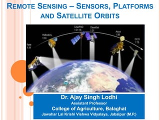
- 22. Satellite Orbits The path followed by a satellite is referred to as its orbit. Satellite orbits are matched to the capability and objective of the sensor(s) they carry. Orbit selection can vary in terms of altitude (their height above the Earth's surface) and their orientation and rotation relative to the Earth. There are several types of orbits: Polar Sun Synchronous Geosynchronous
- 23. Polar Orbits The more correct term would be near polar orbits. These orbits have an inclination near 90 degrees. This allows the satellite to see virtually every part of the Earth as the Earth rotates underneath it. It takes approximately 90 minutes for the satellite to complete one orbit. These satellites have many uses such as measuring ozone concentrations in the stratosphere or measuring temperatures in the atmosphere.
- 24. Sun Synchronous Orbits These orbits allows a satellite to pass over a section of the Earth at the same time of day. Since there are 365 days in a year and 360 degrees in a circle, it means that the satellite has to shift its orbit by approximately one degree per day. These satellites orbit at an altitude between 700 to 800 km. These satellites use the fact since the Earth is not perfectly round (the Earth bulges in the center, the bulge near the equator will cause additional gravitational forces to act on the satellite. This causes the satellite's orbit to either proceed or recede. These orbits are used for satellites that need a constant amount of sunlight. A Sun-synchronous orbit is useful for imaging, spy, and weather satellites, because every time that the satellite is overhead, the surface illumination angle on the planet underneath it will be nearly the same.
- 25. Sun-synchronous orbit (SSO) is a particular kind of polar orbit. Satellites in SSO, travelling over the polar regions, are synchronous with the Sun. This means they are synchronized to always be in the same ‘fixed’ position relative to the Sun. This means that the satellite always visits the same spot at the same local time – for example, passing the city of Paris every day at noon exactly. A satellite in a Sun-synchronous orbit would usually be at an altitude of between 600 to 800 km. At 800 km, it will be travelling at a speed of approximately 7.5 km per second.
- 26. Geosynchronous (Geostationary) Orbits Also known as geostationary orbits, satellites in these orbits circle the Earth at the same rate as the Earth spins. The Earth actually takes 23 hours, 56 minutes, and 4.09 seconds to make one full revolution. So based on Kepler's Laws of Planetary Motion, this would put the satellite at approximately 35,790 km above the Earth. The satellites are located near the equator since at this latitude, there is a constant force of gravity from all directions. At other latitudes, the bulge at the center of the Earth would pull on the satellite.
- 27. Geosynchronous orbits allow the satellite to observe almost a full hemisphere of the Earth. These satellites are used to study large scale phenomenon such as hurricanes, or cyclones. These orbits are also used for communication satellites. The disadvantage of this type of orbit is that since these satellites are very far away, they have poor resolution. Such orbits are useful for telecommunications satellites.
- 28. Thank You