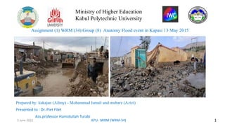
1. Assignment (1) WRM (34) Group (8) Anatomy Flood event in Kapasi 13 May 2015
Prepared by: kakajan (Ailmy) - Mohammad Ismail and mubarz )Azizi(
Presented to : Dr. Piet Filet
Ass.professor Hamidullah TurabiDrDr Piet Filet
Piet Filet
1
KPU- IWRM (WRM-34)
5 June 2022
Ministry of Higher Education
Kabul Polytechnic University
2. Table of contents
1. Introduction.
2. Factors influencing floods.
3. Key factors in floods in Kapisa province.
4. The amount of rainfall that has caused floods.
5. Topography of flood catchment areas in Kapisa province using (GIS).
6. Flood management and prevention strategies in Kapisa province.
7. Challenges.
8. Solution
9. Conclusion
2
KPU- IWRM (WRM-34)
5 June 2022
3. 1. Introduction:
Flood is a natural phenomenon that has been accepted by human societies as an
inevitable event and is considered one of the most costly natural disasters. But
the event, size and frequency of floods are due to several factors that vary
depending on the climatic, natural and geographical conditions of each region.
Due to the fact that floods and damages in most provinces of the country have
an increasing trend and cause death every year, Kapisa province in northeastern
Afghanistan has an area of 1908 square kilometers and a population density of
252 people per square kilometer in one of the most vulnerable province.
Date of flood : 13 May 2015 (5/6/1399)
Location : Hesa-e-awal and Kuhband districts
Flood damage :
20 people were killed
19 people were injured
Destruction of 3500Hec of agricultural land
Extinction of livestock
Demolition of hydraulic buildings
KPU- IWRM (WRM-34) 3
5 June 2022
4. 2.Influential factors in creating floods :
4
KPU- IWRM (WRM-34)
5 June 2022
1. Rapid precipitation and lack of capacity of the place of descent.
2. Impenetrability of the ground and rapid melting of snow.
3. Lack of capacity and lack of proper design of river route and
floods.
4. Lack of use of flood dams and protective walls in flood-prone
areas Mountain collapse.
5. Lack of river dredging and accumulation of heavy and abnormal
sediments behind dams.
6. Damage to flood dams, dams and water tanks.
5. 3. Key factors in floods in Kapisa province
5
KPU- IWRM (WRM-34)
5 June 2022
1. More desire for catchment areas.
2. Deforestation in catchment areas.
3. Lack of material in catchment areas.
4. Taking the sides of waterways by people.
5. Lack of rain gauges in most places.
6. Low awareness of people about floods.
7. Impacts of Climate Change and Drought.
6. 4. The amount of rainfall that has caused floods
According to the statistics of the Meteorological Department, the rainfall in the mentioned areas is between 10-40 mm
and according to the records, the flood is estimated at 30 mm, which shows about 1 hour. The rainfall is in the form of
urographic graphics. Villages in Hesa-e-Awal and Kuhband districts have been affected by valleys. Depending on the
severity of the flood in this area, the Rational Method has been used and the amount of water flow from the floods has
been received as shown in the table below.
No Q_peak(m3/sec) Value C I(mm/hr) A (km2)
Sanjan(A) 70.1 0.278 0.2 30 42
Bolaghain(B) 91.7 0.278 0.2 30 55
Dornama(C) 127 0.278 0.2 30 76
Total 289
6
KPU- IWRM (WRM-34)
5 June 2022
7. 5. Topography of flood catchment areas in Kapisa province using (GIS).
In the following forms, the study and evaluation of GIS software and the use of satellite images obtained the
physiographic characteristics of the watersheds that were most likely to be flooded.
Map of urban rivers in Kapisa province
7
KPU- IWRM (WRM-34)
5 June 2022
8. 6. Flood management and prevention strategies in Kapisa province:
Flood management and appropriate
solutions in Kapisa province:
1. Construction of hydraulic
buildings (shoreline
consolidation, canal gates) .
2. Rehabilitation of green areas
and development of forest
areas.
3. Raising public awareness
through mosques and councils
about floods and preventive
measures about it.
4. Installation of flood warning
signs and rain gauges.
5. Construction of local storage
ponds in catchment areas by
the people.
8
KPU- IWRM (WRM-34)
5 June 2022
9. 7- Challenges:
1. Weak management and low technical capacity of some
relevant departments for flood control before
operation.
2. Lack of flood control buildings.
3. Lack of sufficient budget for the implementation of
infrastructure projects.
4. Uncertainty about private sector investment right now.
5. Lack of infrastructure projects at the provincial level.
6. Construction of residential houses on the banks of
rivers and by the people.
7. Low public awareness and lack of flood warning
devices.
9
KPU- IWRM (WRM-34)
5 June 2022
10. 8- Solution :
1) Upgrading the technical capacity of the relevant departments
to control floods before they occur.
2) Construction of flood control buildings.
3) Allocate sufficient funds to implement projects.
4) Attracting domestic and foreign NGOs and institutions to
invest in the water sector.
5) Arranging complex plans to implement public benefit projects.
6) Public awareness through water associations and local
councils.
7) Implement the laws and regulations of the water sector.
8) Installation of flood warning devices in the path of river and
floods.
10
5 June 2022 KPU- IWRM (WRM-34)
11. To manage floods in Kapisa province, the following results have been achieved, which are as follows.
Comprehensive management and control of water resources.
Strengthening groundwater by separating drains and control buildings.
Increased rains and snow with increasing forests and the creation of tourist and recreational areas.
Creating immunity and protecting the lives and property of the people of Kapisa province.
Preservation of agricultural lands near the coast.
Prevent the destruction of the shores on both sides and the possibility of revitalizing agricultural lands.
Prevent illegal immigration.
Growing people's economy and improving the environment.
9- Conclusion:
11
KPU- IWRM (WRM-34)
5 June 2022