SlideShare a Scribd company logo
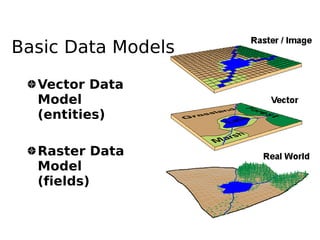
Basic Data Models

  Vector Data
  Model
  (entities)

  Raster Data
  Model
  (fields)
Raster Data Models
  Establishes a pattern of similar grids
  or cells over a geographic area
  The location of each cell is defined by
  its row and column indices
  The value assigned to a cell either
  reflects    the    dominant     feature
  (attribute) at that grid space or
  indicates the presence of a preferred
  feature in case where two or more
  features are present within a single
  grid space
Raster Data Models
  Basic unit in a raster is a cell (or grid
  or pixel)
  Analytically more powerful than the
  vector based GIS
Raster Data Model
3


     5
10
               +               2


                         4
                                                5
                    10             =
                                            9
                                       20
     Direct calculations using raster layers
Comparison between raster and vector
                     Raster    Vector
 Data collection      Rapid     Slow
 Data volume          Large     Small
 Graphic treatment   Average    Good
 Data structure      Simple    Complex
 Geometrical          Low       High
 accuracy
 Analysis in          Poor      Good
 network
 Area analysis        Good     Average
 Generalization      Simple    Complex
Attribute Data
Raster data formats
                             (http://www.gdal.org/formats_list.html)
Arc/Info ASCII Grid , Arc/Info Binary Grid (.adf) , AIRSAR Polarimetric ,
  Microsoft Windows Device Independent Bitmap (.bmp) , BSB Nautical Chart
  Format (.kap) , VTP Binary Terrain Format (.bt) , CEOS (Spot for instance),
  First Generation USGS DOQ (.doq) , DODS / OPeNDAP , New Labelled USGS
  DOQ (.doq) , Military Elevation Data (.dt0, .dt1) , ERMapper Compressed
  Wavelets (.ecw) , ESRI .hdr Labelled , ENVI .hdr Labelled Raster ,
  Envisat Image Product (.n1) , EOSAT FAST Format , FITS (.fits) , Graphics
  Interchange Format (.gif) , Arc/Info Binary Grid (.adf) , GRASS Rasters ,
  TIFF / GeoTIFF (.tif) , Hierarchical Data Format Release 4 (HDF4) ,
  Erdas Imagine (.img) , Atlantis MFF2e , Image Display and Analysis
  (WinDisp) , ILWIS Raster Map (.mpr,.mpl) , Japanese DEM (.mem) , JPEG JFIF
  (.jpg) , JPEG2000 (.jp2, .j2k) , JPEG2000 (.jp2, .j2k) , JPEG2000 (.jp2,
  .j2k) , NOAA Polar Orbiter Level 1b Data Set (AVHRR) , Erdas 7.x .LAN
  and .GIS , In Memory Raster , Atlantis MFF , Multi-resolution Seamless Image
  Database , Meteosat Second Generation , NDF , NITF , NetCDF , OGDI Bridge
  , PCI .aux Labelled , PCI Geomatics Database File , Portable Network
  Graphics (.png) , PCRaster (.map) , Netpbm (.ppm,.pgm) , RadarSat2 XML
  (product.xml) , USGS SDTS DEM (*CATD.DDF) , Raster Matrix Format (*.rsw, .mtw)
  , SAR CEOS , USGS ASCII DEM (.dem) , X11 Pixmap (.xpm)
Creating digital datasets
    by manual input
Georeferencing
●   all spatial data in a common frame of
    reference
●   common coordinate system is plane,
    orthogonal cartesian coordinates
●   referenced with ground and field surveys
    or GPS
●   In GRASS
    –   i.group, i.target, i.points, i.rectify
Northing


           Conformal
           transformation
           X =c 1 ax− by
           Y =c 2 ayby
                            Easting
Raster

More Related Content

What's hot

Spatial Analysis Using GIS
Spatial Analysis Using GISSpatial Analysis Using GIS
Spatial Analysis Using GISPrachi Mehta
 
Raster data model
Raster data modelRaster data model
Raster data modelPramoda Raj
 
Introduction to GIS
Introduction to GISIntroduction to GIS
Introduction to GISJoey Li
 
Getting started with GIS
Getting started with GISGetting started with GIS
Getting started with GISEsri India
 
raster data model
raster data modelraster data model
raster data modelRiya Gupta
 
Remote Sensing:. Image Filtering
Remote Sensing:. Image FilteringRemote Sensing:. Image Filtering
Remote Sensing:. Image FilteringKamlesh Kumar
 
Change detection using remote sensing and GIS
Change detection using remote sensing and GISChange detection using remote sensing and GIS
Change detection using remote sensing and GISTilok Chetri
 
Digital image processing
Digital image processingDigital image processing
Digital image processingMuheeb Awawdeh
 
Spatial analysis and modeling
Spatial analysis and modelingSpatial analysis and modeling
Spatial analysis and modelingTolasa_F
 
Digital image processing
Digital image processingDigital image processing
Digital image processingVandana Verma
 
Gis training ppt
Gis training pptGis training ppt
Gis training pptglobalp7
 

What's hot (20)

Spatial Analysis Using GIS
Spatial Analysis Using GISSpatial Analysis Using GIS
Spatial Analysis Using GIS
 
Raster data model
Raster data modelRaster data model
Raster data model
 
Digital image processing
Digital image processingDigital image processing
Digital image processing
 
Introduction to GIS
Introduction to GISIntroduction to GIS
Introduction to GIS
 
GIS - lecture-1.ppt
GIS - lecture-1.pptGIS - lecture-1.ppt
GIS - lecture-1.ppt
 
Gis
GisGis
Gis
 
GIS data structure
GIS data structureGIS data structure
GIS data structure
 
Getting started with GIS
Getting started with GISGetting started with GIS
Getting started with GIS
 
Gis functions
Gis functionsGis functions
Gis functions
 
Types of GIS Data
Types of GIS DataTypes of GIS Data
Types of GIS Data
 
raster data model
raster data modelraster data model
raster data model
 
Introduction to gis
Introduction to gisIntroduction to gis
Introduction to gis
 
Remote Sensing:. Image Filtering
Remote Sensing:. Image FilteringRemote Sensing:. Image Filtering
Remote Sensing:. Image Filtering
 
Introduction to GIS
Introduction to GISIntroduction to GIS
Introduction to GIS
 
Change detection using remote sensing and GIS
Change detection using remote sensing and GISChange detection using remote sensing and GIS
Change detection using remote sensing and GIS
 
GIS Data Types
GIS Data TypesGIS Data Types
GIS Data Types
 
Digital image processing
Digital image processingDigital image processing
Digital image processing
 
Spatial analysis and modeling
Spatial analysis and modelingSpatial analysis and modeling
Spatial analysis and modeling
 
Digital image processing
Digital image processingDigital image processing
Digital image processing
 
Gis training ppt
Gis training pptGis training ppt
Gis training ppt
 

Viewers also liked

Data models in geographical information system(GIS)
Data models in geographical information system(GIS)Data models in geographical information system(GIS)
Data models in geographical information system(GIS)Pramoda Raj
 
Raster and vector
Raster and vectorRaster and vector
Raster and vectorleeanne123
 
Vector graphics and raster graphics
Vector graphics and raster graphicsVector graphics and raster graphics
Vector graphics and raster graphicsstephlizahawkins123
 
Raster Vs. Vector Presentation1
Raster Vs. Vector Presentation1Raster Vs. Vector Presentation1
Raster Vs. Vector Presentation1cdoeberl
 
Vectors
VectorsVectors
Vectorseliseb
 
Vector & raster graphic
Vector & raster graphicVector & raster graphic
Vector & raster graphicKhang-Ling Loh
 
Topology presentation
Topology  presentationTopology  presentation
Topology presentationJobaida Nahar
 
Introduction to Vectors
Introduction to VectorsIntroduction to Vectors
Introduction to VectorsM.T.H Group
 
Spatial vs non spatial
Spatial vs non spatialSpatial vs non spatial
Spatial vs non spatialSumant Diwakar
 
Chemical bonding
Chemical bondingChemical bonding
Chemical bondingPramoda Raj
 
Tours les jours2
Tours les jours2Tours les jours2
Tours les jours2chanpinqi
 
Rastar Capabilities
Rastar CapabilitiesRastar Capabilities
Rastar Capabilitiesbsattree
 
datamodel_vector
datamodel_vectordatamodel_vector
datamodel_vectorRiya Gupta
 

Viewers also liked (20)

Topology in GIS
Topology in GISTopology in GIS
Topology in GIS
 
Data models in geographical information system(GIS)
Data models in geographical information system(GIS)Data models in geographical information system(GIS)
Data models in geographical information system(GIS)
 
Raster and vector
Raster and vectorRaster and vector
Raster and vector
 
Vector graphics and raster graphics
Vector graphics and raster graphicsVector graphics and raster graphics
Vector graphics and raster graphics
 
Raster Vs. Vector Presentation1
Raster Vs. Vector Presentation1Raster Vs. Vector Presentation1
Raster Vs. Vector Presentation1
 
Vectors
VectorsVectors
Vectors
 
Vector & raster graphic
Vector & raster graphicVector & raster graphic
Vector & raster graphic
 
Topology presentation
Topology  presentationTopology  presentation
Topology presentation
 
Introduction to Vectors
Introduction to VectorsIntroduction to Vectors
Introduction to Vectors
 
Spatial vs non spatial
Spatial vs non spatialSpatial vs non spatial
Spatial vs non spatial
 
Vectors
VectorsVectors
Vectors
 
Vectors
Vectors Vectors
Vectors
 
Chemical bonding
Chemical bondingChemical bonding
Chemical bonding
 
Bb geodatabase
Bb geodatabaseBb geodatabase
Bb geodatabase
 
Tours les jours2
Tours les jours2Tours les jours2
Tours les jours2
 
Rastar Capabilities
Rastar CapabilitiesRastar Capabilities
Rastar Capabilities
 
Spatial Data Model
Spatial Data ModelSpatial Data Model
Spatial Data Model
 
datamodel_vector
datamodel_vectordatamodel_vector
datamodel_vector
 
GIS & Raster
GIS & RasterGIS & Raster
GIS & Raster
 
functions of GIS
functions of GISfunctions of GIS
functions of GIS
 

Similar to Raster

Conceptual models of real world geographical phenomena (epm107_2007)
Conceptual models of real world geographical phenomena (epm107_2007)Conceptual models of real world geographical phenomena (epm107_2007)
Conceptual models of real world geographical phenomena (epm107_2007)esambale
 
belajar dasar geospatial sistem informasi geografi
belajar dasar geospatial sistem informasi geografibelajar dasar geospatial sistem informasi geografi
belajar dasar geospatial sistem informasi geografiRizal Siguniska
 
Raster data model
Raster data modelRaster data model
Raster data modelPramoda Raj
 
Scattered gis handbook
Scattered gis handbookScattered gis handbook
Scattered gis handbookWaleed Liaqat
 
FME Lightning Talk: Raster
FME Lightning Talk: RasterFME Lightning Talk: Raster
FME Lightning Talk: RasterSafe Software
 
FME 2012 World Tour - Lightning Talk on Rasters
FME 2012 World Tour - Lightning Talk on RastersFME 2012 World Tour - Lightning Talk on Rasters
FME 2012 World Tour - Lightning Talk on RastersIMGS
 
Practical data science_public
Practical data science_publicPractical data science_public
Practical data science_publicLong Nguyen
 
Stockage, manipulation et analyse de données matricielles avec PostGIS Raster
Stockage, manipulation et analyse de données matricielles avec PostGIS RasterStockage, manipulation et analyse de données matricielles avec PostGIS Raster
Stockage, manipulation et analyse de données matricielles avec PostGIS RasterACSG Section Montréal
 
Lect 5 data models-gis
Lect 5 data models-gisLect 5 data models-gis
Lect 5 data models-gisRehana Jamal
 
introduction to geographical information system
introduction to geographical information systemintroduction to geographical information system
introduction to geographical information systemDrVenkateswarluGogan1
 
UG6thSem_major_GIS Data Structures.pptx DR P DAS.1.pptx
UG6thSem_major_GIS Data Structures.pptx DR P DAS.1.pptxUG6thSem_major_GIS Data Structures.pptx DR P DAS.1.pptx
UG6thSem_major_GIS Data Structures.pptx DR P DAS.1.pptxNancyVerma72
 
Modelo de dados vetorial e matricial - slides
Modelo de dados vetorial e matricial - slidesModelo de dados vetorial e matricial - slides
Modelo de dados vetorial e matricial - slidesLuzianeRibeiroIndjai
 
GIS and Mapping Software Introduction
GIS and Mapping Software IntroductionGIS and Mapping Software Introduction
GIS and Mapping Software IntroductionMEASURE Evaluation
 
33286 gis%20 lecture%20six-1
33286 gis%20 lecture%20six-133286 gis%20 lecture%20six-1
33286 gis%20 lecture%20six-1Hisham Ibnuqaiyim
 
spatial databases ADBMS ppt
spatial databases ADBMS pptspatial databases ADBMS ppt
spatial databases ADBMS pptRitaThakkar1
 
Skills portfolio
Skills portfolioSkills portfolio
Skills portfolioyeboyerp
 
the title of this course is Entitles as GIS and Remote sensing
the title of this course is Entitles as GIS and Remote sensingthe title of this course is Entitles as GIS and Remote sensing
the title of this course is Entitles as GIS and Remote sensingmulugeta48
 

Similar to Raster (20)

Conceptual models of real world geographical phenomena (epm107_2007)
Conceptual models of real world geographical phenomena (epm107_2007)Conceptual models of real world geographical phenomena (epm107_2007)
Conceptual models of real world geographical phenomena (epm107_2007)
 
Gis Concepts 2/5
Gis Concepts 2/5Gis Concepts 2/5
Gis Concepts 2/5
 
belajar dasar geospatial sistem informasi geografi
belajar dasar geospatial sistem informasi geografibelajar dasar geospatial sistem informasi geografi
belajar dasar geospatial sistem informasi geografi
 
Raster data model
Raster data modelRaster data model
Raster data model
 
Scattered gis handbook
Scattered gis handbookScattered gis handbook
Scattered gis handbook
 
FME Lightning Talk: Raster
FME Lightning Talk: RasterFME Lightning Talk: Raster
FME Lightning Talk: Raster
 
FME 2012 World Tour - Lightning Talk on Rasters
FME 2012 World Tour - Lightning Talk on RastersFME 2012 World Tour - Lightning Talk on Rasters
FME 2012 World Tour - Lightning Talk on Rasters
 
Practical data science_public
Practical data science_publicPractical data science_public
Practical data science_public
 
Understanding raster
Understanding rasterUnderstanding raster
Understanding raster
 
Stockage, manipulation et analyse de données matricielles avec PostGIS Raster
Stockage, manipulation et analyse de données matricielles avec PostGIS RasterStockage, manipulation et analyse de données matricielles avec PostGIS Raster
Stockage, manipulation et analyse de données matricielles avec PostGIS Raster
 
Lect 5 data models-gis
Lect 5 data models-gisLect 5 data models-gis
Lect 5 data models-gis
 
Geographical Information System (GIS)
Geographical Information System (GIS)Geographical Information System (GIS)
Geographical Information System (GIS)
 
introduction to geographical information system
introduction to geographical information systemintroduction to geographical information system
introduction to geographical information system
 
UG6thSem_major_GIS Data Structures.pptx DR P DAS.1.pptx
UG6thSem_major_GIS Data Structures.pptx DR P DAS.1.pptxUG6thSem_major_GIS Data Structures.pptx DR P DAS.1.pptx
UG6thSem_major_GIS Data Structures.pptx DR P DAS.1.pptx
 
Modelo de dados vetorial e matricial - slides
Modelo de dados vetorial e matricial - slidesModelo de dados vetorial e matricial - slides
Modelo de dados vetorial e matricial - slides
 
GIS and Mapping Software Introduction
GIS and Mapping Software IntroductionGIS and Mapping Software Introduction
GIS and Mapping Software Introduction
 
33286 gis%20 lecture%20six-1
33286 gis%20 lecture%20six-133286 gis%20 lecture%20six-1
33286 gis%20 lecture%20six-1
 
spatial databases ADBMS ppt
spatial databases ADBMS pptspatial databases ADBMS ppt
spatial databases ADBMS ppt
 
Skills portfolio
Skills portfolioSkills portfolio
Skills portfolio
 
the title of this course is Entitles as GIS and Remote sensing
the title of this course is Entitles as GIS and Remote sensingthe title of this course is Entitles as GIS and Remote sensing
the title of this course is Entitles as GIS and Remote sensing
 

More from esambale

Open data initiatives
Open data initiativesOpen data initiatives
Open data initiativesesambale
 
Contributing to OpenStreetMap (OSMPH)
Contributing to OpenStreetMap (OSMPH)Contributing to OpenStreetMap (OSMPH)
Contributing to OpenStreetMap (OSMPH)esambale
 
About osmph
About osmphAbout osmph
About osmphesambale
 
Map design
Map designMap design
Map designesambale
 
Geoladies 20140609
Geoladies 20140609Geoladies 20140609
Geoladies 20140609esambale
 
DepEd's Schools Mapping Initiative
DepEd's Schools Mapping InitiativeDepEd's Schools Mapping Initiative
DepEd's Schools Mapping Initiativeesambale
 
State of OpenStreetMap Indonesia
State of OpenStreetMap IndonesiaState of OpenStreetMap Indonesia
State of OpenStreetMap Indonesiaesambale
 
Using OSM, QGIS, and InaSAFE for Contingency Plan in Indonesia
Using OSM, QGIS, and InaSAFE for Contingency Plan in Indonesia Using OSM, QGIS, and InaSAFE for Contingency Plan in Indonesia
Using OSM, QGIS, and InaSAFE for Contingency Plan in Indonesia esambale
 
Participatory mapping and LGU decision support tools for Disaster Risk Reduct...
Participatory mapping and LGU decision support tools for Disaster Risk Reduct...Participatory mapping and LGU decision support tools for Disaster Risk Reduct...
Participatory mapping and LGU decision support tools for Disaster Risk Reduct...esambale
 
InaSAFE Development in the Philippines
InaSAFE Development in the Philippines InaSAFE Development in the Philippines
InaSAFE Development in the Philippines esambale
 
Maperitive
MaperitiveMaperitive
Maperitiveesambale
 
OpenStreetMap QA tools
OpenStreetMap QA toolsOpenStreetMap QA tools
OpenStreetMap QA toolsesambale
 
My GPS Stories
My GPS StoriesMy GPS Stories
My GPS Storiesesambale
 
OSM-Philippines and the Yolanda Crisis Mapping Response
OSM-Philippines and the Yolanda Crisis Mapping ResponseOSM-Philippines and the Yolanda Crisis Mapping Response
OSM-Philippines and the Yolanda Crisis Mapping Responseesambale
 
Free GEO Culture and OpenStreetMap
Free GEO Culture and OpenStreetMapFree GEO Culture and OpenStreetMap
Free GEO Culture and OpenStreetMapesambale
 
ESSC OSM-PH WB project
ESSC OSM-PH WB projectESSC OSM-PH WB project
ESSC OSM-PH WB projectesambale
 
Philippine Geospatial Forum Presentation 20130311
Philippine Geospatial Forum Presentation 20130311Philippine Geospatial Forum Presentation 20130311
Philippine Geospatial Forum Presentation 20130311esambale
 
OSM SFD2012
OSM SFD2012OSM SFD2012
OSM SFD2012esambale
 
FOSS4G 2011 Osaka
FOSS4G 2011 OsakaFOSS4G 2011 Osaka
FOSS4G 2011 Osakaesambale
 
foss4g 2011 tokyo
foss4g 2011 tokyofoss4g 2011 tokyo
foss4g 2011 tokyoesambale
 

More from esambale (20)

Open data initiatives
Open data initiativesOpen data initiatives
Open data initiatives
 
Contributing to OpenStreetMap (OSMPH)
Contributing to OpenStreetMap (OSMPH)Contributing to OpenStreetMap (OSMPH)
Contributing to OpenStreetMap (OSMPH)
 
About osmph
About osmphAbout osmph
About osmph
 
Map design
Map designMap design
Map design
 
Geoladies 20140609
Geoladies 20140609Geoladies 20140609
Geoladies 20140609
 
DepEd's Schools Mapping Initiative
DepEd's Schools Mapping InitiativeDepEd's Schools Mapping Initiative
DepEd's Schools Mapping Initiative
 
State of OpenStreetMap Indonesia
State of OpenStreetMap IndonesiaState of OpenStreetMap Indonesia
State of OpenStreetMap Indonesia
 
Using OSM, QGIS, and InaSAFE for Contingency Plan in Indonesia
Using OSM, QGIS, and InaSAFE for Contingency Plan in Indonesia Using OSM, QGIS, and InaSAFE for Contingency Plan in Indonesia
Using OSM, QGIS, and InaSAFE for Contingency Plan in Indonesia
 
Participatory mapping and LGU decision support tools for Disaster Risk Reduct...
Participatory mapping and LGU decision support tools for Disaster Risk Reduct...Participatory mapping and LGU decision support tools for Disaster Risk Reduct...
Participatory mapping and LGU decision support tools for Disaster Risk Reduct...
 
InaSAFE Development in the Philippines
InaSAFE Development in the Philippines InaSAFE Development in the Philippines
InaSAFE Development in the Philippines
 
Maperitive
MaperitiveMaperitive
Maperitive
 
OpenStreetMap QA tools
OpenStreetMap QA toolsOpenStreetMap QA tools
OpenStreetMap QA tools
 
My GPS Stories
My GPS StoriesMy GPS Stories
My GPS Stories
 
OSM-Philippines and the Yolanda Crisis Mapping Response
OSM-Philippines and the Yolanda Crisis Mapping ResponseOSM-Philippines and the Yolanda Crisis Mapping Response
OSM-Philippines and the Yolanda Crisis Mapping Response
 
Free GEO Culture and OpenStreetMap
Free GEO Culture and OpenStreetMapFree GEO Culture and OpenStreetMap
Free GEO Culture and OpenStreetMap
 
ESSC OSM-PH WB project
ESSC OSM-PH WB projectESSC OSM-PH WB project
ESSC OSM-PH WB project
 
Philippine Geospatial Forum Presentation 20130311
Philippine Geospatial Forum Presentation 20130311Philippine Geospatial Forum Presentation 20130311
Philippine Geospatial Forum Presentation 20130311
 
OSM SFD2012
OSM SFD2012OSM SFD2012
OSM SFD2012
 
FOSS4G 2011 Osaka
FOSS4G 2011 OsakaFOSS4G 2011 Osaka
FOSS4G 2011 Osaka
 
foss4g 2011 tokyo
foss4g 2011 tokyofoss4g 2011 tokyo
foss4g 2011 tokyo
 

Recently uploaded

Search and Society: Reimagining Information Access for Radical Futures
Search and Society: Reimagining Information Access for Radical FuturesSearch and Society: Reimagining Information Access for Radical Futures
Search and Society: Reimagining Information Access for Radical FuturesBhaskar Mitra
 
PLAI - Acceleration Program for Generative A.I. Startups
PLAI - Acceleration Program for Generative A.I. StartupsPLAI - Acceleration Program for Generative A.I. Startups
PLAI - Acceleration Program for Generative A.I. StartupsStefano
 
What's New in Teams Calling, Meetings and Devices April 2024
What's New in Teams Calling, Meetings and Devices April 2024What's New in Teams Calling, Meetings and Devices April 2024
What's New in Teams Calling, Meetings and Devices April 2024Stephanie Beckett
 
Future Visions: Predictions to Guide and Time Tech Innovation, Peter Udo Diehl
Future Visions: Predictions to Guide and Time Tech Innovation, Peter Udo DiehlFuture Visions: Predictions to Guide and Time Tech Innovation, Peter Udo Diehl
Future Visions: Predictions to Guide and Time Tech Innovation, Peter Udo DiehlPeter Udo Diehl
 
Key Trends Shaping the Future of Infrastructure.pdf
Key Trends Shaping the Future of Infrastructure.pdfKey Trends Shaping the Future of Infrastructure.pdf
Key Trends Shaping the Future of Infrastructure.pdfCheryl Hung
 
The architecture of Generative AI for enterprises.pdf
The architecture of Generative AI for enterprises.pdfThe architecture of Generative AI for enterprises.pdf
The architecture of Generative AI for enterprises.pdfalexjohnson7307
 
Demystifying gRPC in .Net by John Staveley
Demystifying gRPC in .Net by John StaveleyDemystifying gRPC in .Net by John Staveley
Demystifying gRPC in .Net by John StaveleyJohn Staveley
 
JMeter webinar - integration with InfluxDB and Grafana
JMeter webinar - integration with InfluxDB and GrafanaJMeter webinar - integration with InfluxDB and Grafana
JMeter webinar - integration with InfluxDB and GrafanaRTTS
 
10 Differences between Sales Cloud and CPQ, Blanka Doktorová
10 Differences between Sales Cloud and CPQ, Blanka Doktorová10 Differences between Sales Cloud and CPQ, Blanka Doktorová
10 Differences between Sales Cloud and CPQ, Blanka DoktorováCzechDreamin
 
Custom Approval Process: A New Perspective, Pavel Hrbacek & Anindya Halder
Custom Approval Process: A New Perspective, Pavel Hrbacek & Anindya HalderCustom Approval Process: A New Perspective, Pavel Hrbacek & Anindya Halder
Custom Approval Process: A New Perspective, Pavel Hrbacek & Anindya HalderCzechDreamin
 
Agentic RAG What it is its types applications and implementation.pdf
Agentic RAG What it is its types applications and implementation.pdfAgentic RAG What it is its types applications and implementation.pdf
Agentic RAG What it is its types applications and implementation.pdfChristopherTHyatt
 
In-Depth Performance Testing Guide for IT Professionals
In-Depth Performance Testing Guide for IT ProfessionalsIn-Depth Performance Testing Guide for IT Professionals
In-Depth Performance Testing Guide for IT ProfessionalsExpeed Software
 
Empowering NextGen Mobility via Large Action Model Infrastructure (LAMI): pav...
Empowering NextGen Mobility via Large Action Model Infrastructure (LAMI): pav...Empowering NextGen Mobility via Large Action Model Infrastructure (LAMI): pav...
Empowering NextGen Mobility via Large Action Model Infrastructure (LAMI): pav...Thierry Lestable
 
Speed Wins: From Kafka to APIs in Minutes
Speed Wins: From Kafka to APIs in MinutesSpeed Wins: From Kafka to APIs in Minutes
Speed Wins: From Kafka to APIs in Minutesconfluent
 
Integrating Telephony Systems with Salesforce: Insights and Considerations, B...
Integrating Telephony Systems with Salesforce: Insights and Considerations, B...Integrating Telephony Systems with Salesforce: Insights and Considerations, B...
Integrating Telephony Systems with Salesforce: Insights and Considerations, B...CzechDreamin
 
From Daily Decisions to Bottom Line: Connecting Product Work to Revenue by VP...
From Daily Decisions to Bottom Line: Connecting Product Work to Revenue by VP...From Daily Decisions to Bottom Line: Connecting Product Work to Revenue by VP...
From Daily Decisions to Bottom Line: Connecting Product Work to Revenue by VP...Product School
 
WSO2CONMay2024OpenSourceConferenceDebrief.pptx
WSO2CONMay2024OpenSourceConferenceDebrief.pptxWSO2CONMay2024OpenSourceConferenceDebrief.pptx
WSO2CONMay2024OpenSourceConferenceDebrief.pptxJennifer Lim
 
Designing Great Products: The Power of Design and Leadership by Chief Designe...
Designing Great Products: The Power of Design and Leadership by Chief Designe...Designing Great Products: The Power of Design and Leadership by Chief Designe...
Designing Great Products: The Power of Design and Leadership by Chief Designe...Product School
 
Bits & Pixels using AI for Good.........
Bits & Pixels using AI for Good.........Bits & Pixels using AI for Good.........
Bits & Pixels using AI for Good.........Alison B. Lowndes
 
IESVE for Early Stage Design and Planning
IESVE for Early Stage Design and PlanningIESVE for Early Stage Design and Planning
IESVE for Early Stage Design and PlanningIES VE
 

Recently uploaded (20)

Search and Society: Reimagining Information Access for Radical Futures
Search and Society: Reimagining Information Access for Radical FuturesSearch and Society: Reimagining Information Access for Radical Futures
Search and Society: Reimagining Information Access for Radical Futures
 
PLAI - Acceleration Program for Generative A.I. Startups
PLAI - Acceleration Program for Generative A.I. StartupsPLAI - Acceleration Program for Generative A.I. Startups
PLAI - Acceleration Program for Generative A.I. Startups
 
What's New in Teams Calling, Meetings and Devices April 2024
What's New in Teams Calling, Meetings and Devices April 2024What's New in Teams Calling, Meetings and Devices April 2024
What's New in Teams Calling, Meetings and Devices April 2024
 
Future Visions: Predictions to Guide and Time Tech Innovation, Peter Udo Diehl
Future Visions: Predictions to Guide and Time Tech Innovation, Peter Udo DiehlFuture Visions: Predictions to Guide and Time Tech Innovation, Peter Udo Diehl
Future Visions: Predictions to Guide and Time Tech Innovation, Peter Udo Diehl
 
Key Trends Shaping the Future of Infrastructure.pdf
Key Trends Shaping the Future of Infrastructure.pdfKey Trends Shaping the Future of Infrastructure.pdf
Key Trends Shaping the Future of Infrastructure.pdf
 
The architecture of Generative AI for enterprises.pdf
The architecture of Generative AI for enterprises.pdfThe architecture of Generative AI for enterprises.pdf
The architecture of Generative AI for enterprises.pdf
 
Demystifying gRPC in .Net by John Staveley
Demystifying gRPC in .Net by John StaveleyDemystifying gRPC in .Net by John Staveley
Demystifying gRPC in .Net by John Staveley
 
JMeter webinar - integration with InfluxDB and Grafana
JMeter webinar - integration with InfluxDB and GrafanaJMeter webinar - integration with InfluxDB and Grafana
JMeter webinar - integration with InfluxDB and Grafana
 
10 Differences between Sales Cloud and CPQ, Blanka Doktorová
10 Differences between Sales Cloud and CPQ, Blanka Doktorová10 Differences between Sales Cloud and CPQ, Blanka Doktorová
10 Differences between Sales Cloud and CPQ, Blanka Doktorová
 
Custom Approval Process: A New Perspective, Pavel Hrbacek & Anindya Halder
Custom Approval Process: A New Perspective, Pavel Hrbacek & Anindya HalderCustom Approval Process: A New Perspective, Pavel Hrbacek & Anindya Halder
Custom Approval Process: A New Perspective, Pavel Hrbacek & Anindya Halder
 
Agentic RAG What it is its types applications and implementation.pdf
Agentic RAG What it is its types applications and implementation.pdfAgentic RAG What it is its types applications and implementation.pdf
Agentic RAG What it is its types applications and implementation.pdf
 
In-Depth Performance Testing Guide for IT Professionals
In-Depth Performance Testing Guide for IT ProfessionalsIn-Depth Performance Testing Guide for IT Professionals
In-Depth Performance Testing Guide for IT Professionals
 
Empowering NextGen Mobility via Large Action Model Infrastructure (LAMI): pav...
Empowering NextGen Mobility via Large Action Model Infrastructure (LAMI): pav...Empowering NextGen Mobility via Large Action Model Infrastructure (LAMI): pav...
Empowering NextGen Mobility via Large Action Model Infrastructure (LAMI): pav...
 
Speed Wins: From Kafka to APIs in Minutes
Speed Wins: From Kafka to APIs in MinutesSpeed Wins: From Kafka to APIs in Minutes
Speed Wins: From Kafka to APIs in Minutes
 
Integrating Telephony Systems with Salesforce: Insights and Considerations, B...
Integrating Telephony Systems with Salesforce: Insights and Considerations, B...Integrating Telephony Systems with Salesforce: Insights and Considerations, B...
Integrating Telephony Systems with Salesforce: Insights and Considerations, B...
 
From Daily Decisions to Bottom Line: Connecting Product Work to Revenue by VP...
From Daily Decisions to Bottom Line: Connecting Product Work to Revenue by VP...From Daily Decisions to Bottom Line: Connecting Product Work to Revenue by VP...
From Daily Decisions to Bottom Line: Connecting Product Work to Revenue by VP...
 
WSO2CONMay2024OpenSourceConferenceDebrief.pptx
WSO2CONMay2024OpenSourceConferenceDebrief.pptxWSO2CONMay2024OpenSourceConferenceDebrief.pptx
WSO2CONMay2024OpenSourceConferenceDebrief.pptx
 
Designing Great Products: The Power of Design and Leadership by Chief Designe...
Designing Great Products: The Power of Design and Leadership by Chief Designe...Designing Great Products: The Power of Design and Leadership by Chief Designe...
Designing Great Products: The Power of Design and Leadership by Chief Designe...
 
Bits & Pixels using AI for Good.........
Bits & Pixels using AI for Good.........Bits & Pixels using AI for Good.........
Bits & Pixels using AI for Good.........
 
IESVE for Early Stage Design and Planning
IESVE for Early Stage Design and PlanningIESVE for Early Stage Design and Planning
IESVE for Early Stage Design and Planning
 

Raster

  • 1. Basic Data Models Vector Data Model (entities) Raster Data Model (fields)
  • 2. Raster Data Models Establishes a pattern of similar grids or cells over a geographic area The location of each cell is defined by its row and column indices The value assigned to a cell either reflects the dominant feature (attribute) at that grid space or indicates the presence of a preferred feature in case where two or more features are present within a single grid space
  • 3. Raster Data Models Basic unit in a raster is a cell (or grid or pixel) Analytically more powerful than the vector based GIS
  • 4.
  • 6. 3 5 10 + 2 4 5 10 = 9 20 Direct calculations using raster layers
  • 7. Comparison between raster and vector Raster Vector Data collection Rapid Slow Data volume Large Small Graphic treatment Average Good Data structure Simple Complex Geometrical Low High accuracy Analysis in Poor Good network Area analysis Good Average Generalization Simple Complex
  • 9. Raster data formats (http://www.gdal.org/formats_list.html) Arc/Info ASCII Grid , Arc/Info Binary Grid (.adf) , AIRSAR Polarimetric , Microsoft Windows Device Independent Bitmap (.bmp) , BSB Nautical Chart Format (.kap) , VTP Binary Terrain Format (.bt) , CEOS (Spot for instance), First Generation USGS DOQ (.doq) , DODS / OPeNDAP , New Labelled USGS DOQ (.doq) , Military Elevation Data (.dt0, .dt1) , ERMapper Compressed Wavelets (.ecw) , ESRI .hdr Labelled , ENVI .hdr Labelled Raster , Envisat Image Product (.n1) , EOSAT FAST Format , FITS (.fits) , Graphics Interchange Format (.gif) , Arc/Info Binary Grid (.adf) , GRASS Rasters , TIFF / GeoTIFF (.tif) , Hierarchical Data Format Release 4 (HDF4) , Erdas Imagine (.img) , Atlantis MFF2e , Image Display and Analysis (WinDisp) , ILWIS Raster Map (.mpr,.mpl) , Japanese DEM (.mem) , JPEG JFIF (.jpg) , JPEG2000 (.jp2, .j2k) , JPEG2000 (.jp2, .j2k) , JPEG2000 (.jp2, .j2k) , NOAA Polar Orbiter Level 1b Data Set (AVHRR) , Erdas 7.x .LAN and .GIS , In Memory Raster , Atlantis MFF , Multi-resolution Seamless Image Database , Meteosat Second Generation , NDF , NITF , NetCDF , OGDI Bridge , PCI .aux Labelled , PCI Geomatics Database File , Portable Network Graphics (.png) , PCRaster (.map) , Netpbm (.ppm,.pgm) , RadarSat2 XML (product.xml) , USGS SDTS DEM (*CATD.DDF) , Raster Matrix Format (*.rsw, .mtw) , SAR CEOS , USGS ASCII DEM (.dem) , X11 Pixmap (.xpm)
  • 10. Creating digital datasets by manual input
  • 11. Georeferencing ● all spatial data in a common frame of reference ● common coordinate system is plane, orthogonal cartesian coordinates ● referenced with ground and field surveys or GPS ● In GRASS – i.group, i.target, i.points, i.rectify
  • 12. Northing Conformal transformation X =c 1 ax− by Y =c 2 ayby Easting