COASTAL PLANTS OF RHODES BOTANICAL GARDEN
•Download as PPTX, PDF•
1 like•926 views

Preliminary study for the creation of a small Botanical garden of the coastal plants of Rhodes island at the Rhodes Aquarium Gardens
Report
Share
Report
Share

Recommended
Types of water bodies marine water
The document describes the marine biome. It discusses that there are two main types of aquatic biomes: marine water and fresh water. The marine biome is characterized by salt water and is the largest biome. It describes the six major marine ecosystems: (1) open marine, (2) ocean floor, (3) coral reef, (4) estuary, (5) saltwater wetland, and (6) mangrove ecosystems. These ecosystems have unique characteristics and provide habitat for diverse marine species.
Mangrove ecosystem
Mangrove ecosystems are found in tropical and subtropical coastal regions around the world. Mangroves are trees and shrubs that have adapted to grow in saline coastal habitats. They play an important role in buffering coastlines from storms and reducing erosion. However, mangroves are increasingly threatened by human development and destruction of coastal habitats. When mangroves are cut down or degraded, it damages the complex coastal ecosystem and removes natural protections for the shoreline.
Coastal Systems - Salt Marsh Vegetation
This document summarizes the vegetation zones of Florida salt marshes. Salt marshes occur in intertidal zones along coastlines with low wave energy. Vegetation zones are determined by elevation and tidal flooding, ranging from the Spartina alterniflora zone at lowest elevations flooded daily, to a transitional shrub zone and upland forest. Within each zone, plant diversity and species composition is determined by salinity and soil conditions. Common plant species are described for each zone, from smooth cordgrass and black needlerush at lower elevations, to glassworts, saltgrass and sea lavender in salt flats, and bluestems, goldenrods and shrubs at higher elevations.
coastal wetland and its thereats
Wetlands provide important ecosystem services but face many threats. On-site threats include draining wetlands for agriculture, dumping waste, and pollution from nearby activities. Off-site threats involve upstream deforestation, dams altering water flows, and pollution from distant sources. A key threat is conversion to aquaculture through draining or filling wetlands. Wetlands are drained and filled to make way for shrimp or fish farms, eliminating natural habitat.
L11 salt marshes ap
Salt marshes form in sheltered coastal areas where mud and silt accumulate. Unique salt-tolerant plants colonize these areas, trapping sediment and improving soil quality over time. Keyhaven Salt Marsh in particular supports a rich natural habitat and diversity of wildlife, and efforts are made to conserve and sustainably use the area while educating visitors on protecting this fragile ecosystem.
The Mangrove Ecosystem
Mangroves provide many important ecological functions by dropping leaves that form the base of the food web, hosting complex predator-prey relationships, and providing protected nurseries for juvenile fish through their prop roots. Their extensive root systems also aid in erosion control, sediment trapping, water filtration, and prevention of saltwater intrusion, helping to protect coastlines and water quality. However, mangroves face threats that undermine these crucial ecosystem services.
Aquatic plants
This document provides information on various types of aquatic and marine plants. It begins by discussing the importance of water on Earth and the role of algae in producing oxygen and sequestering carbon. It then describes the divisions of algae and provides examples of species from each division. The document outlines the life cycles and reproductive strategies of different types of algae. It also discusses seaweeds, their uses, and the author's research on seaweeds. Finally, it briefly covers other aquatic plants like seagrasses, mangroves, freshwater algae, lichens, bryophytes, ferns, and invasive species.
Coastal Communities
Salt marsh communities are found in protected coastal areas dominated by salt-tolerant grasses. They provide important habitat for many species of fish, birds, and invertebrates. Salt marshes act as natural buffers against flooding and filter pollutants from water. However, they face threats from development, ditching, overharvesting, and other human impacts. Mud flats adjacent to salt marshes provide habitat for diverse invertebrate communities and feeding grounds for other species. Seagrass beds in shallow coastal waters create structured habitat and nurseries while improving water quality and moderating currents. However, they are threatened by boat damage, declining water quality from runoff, and rising sea levels. Rocky intertidal
UC CESDEV 2 Aa Mangroove Planting Orientation
Mangroves are important coastal trees that provide many benefits. They act as barriers between land and sea, protecting communities from waves. Mangrove root systems create habitats for fish, birds, and other animals. Mangroves also filter runoff, buffer storms, and stabilize shorelines. Mangroves grow in intertidal zones with soft mud and are planted directly or raised in nurseries. Planting involves selecting healthy seedlings and protecting the areas from grazing. Mangroves should be conserved as they are ecologically important coastal ecosystems.
Seagrass Watch
The document discusses the Great Sandy Strait Seagrass Watch and Monitoring Program. It provides background on seagrass loss in the area due to a 1992 cyclone, and the establishment of a community-based seagrass monitoring program in 1998. The Great Sandy Strait Seagrass Watch and Monitoring Program monitors 18 sites, 10 of which can only be accessed by boat. Seagrasses in the area provide important habitat but were damaged by the cyclone.
Marine biome
The marine biome covers 70% of the Earth and includes all salty bodies of water like the seven major oceans divided into three layers - the euphotic zone where light reaches, the disphotic twilight zone, and the deep apotic zone without light. It contains a diversity of marine flora like seaweeds, phytoplankton, mangroves and cabbage as well as fauna such as clams, dolphins, octopus, sharks and sea snakes.
Aquatic ecology 101
A Powerpoint on teaching Aquatic Ecology
I found this by doing a "Google Search" on
"Aquatic Ecology" and ".ppt"
I posted this here for the benefit of a young teacher friend, but also wanted to make the point, especially to users of eInstruction's classroom Performance System, that by doing such a search, they can easily find Powerpoints they can use with their CPS system.
Also , Powerpoint will let you "save as " .jpg
so you can also use individual slides as graphics to illustrate individual CPS questions.
Bill McIntosh
843-442-8888
Email: WKMcIntosh@Comcast.net
Authorized eInstruction Consultant
www.eInstruction.com
My profile :
http://www.slideshare.net/WKMcIntosh/bill-mc-intosh-einstruction-consultant-2011
"Some men see things as they are and ask 'Why?'
I dream things that never were and ask, 'Why not?'"
Robert F. Kennedy, 1968
I am using site called Slideshare to post and share information about eInstruction’s products. Here are the links:
http://www.slideshare.net/WKMcIntosh/presentations
http://www.slideshare.net/WKMcIntosh/documents
http://www.slideshare.net/WKMcIntosh/videos
This site allows one to view the files before downloading.
Because I work with some federally sponsored education outreach programs, there are some “K-12 centric” files located here, but also a lot of not only product brochures and information for corporate and government users and Higher Ed users , but also how-to and help files that my clients tell me are very useful
Five classification of an estuarine ecosystem
This document outlines 5 classifications of estuarine ecosystems according to Howard T. Odum:
1. Physically stressed systems that experience high energy waves, currents, temperature/salinity fluctuations or sedimentation. These systems have low diversity but include rocky shores, tidal channels, and man-made canals.
2. Arctic ecosystems with ice stress, including glacial fjords and winter ice zones, which experience light, temperature, and ice limitations.
3. Temperate coastal ecosystems with seasonal programming, like drowned river valleys and embayments, that experience seasonal pulses in productivity and reproduction.
4. Tropical coastal ecosystems of high diversity that experience low physical stresses, allowing greater diversity,
Types of wetlands and wetland formation
This document summarizes the different types and formation of wetlands. It discusses two major wetland types based on soil - mineral wetlands like marshes and swamps, and organic wetlands like bogs and fens. It also describes the Cowardin and Ramsar classification systems which further categorize wetlands based on vegetation, hydrology, and other characteristics. Wetlands form through natural processes like climate, glaciation, and flooding or through human activities such as forest cutting, peat extraction, and construction.
stratification of water environments -
The document stratifies different aquatic biomes as follows:
1. Freshwater biomes include ponds, lakes, streams and rivers. Ponds and lakes are divided into littoral, limnetic and profundal zones. Streams and rivers have headwaters, middle sections and mouths.
2. Transitional waters between freshwater and saltwater include estuaries and wetlands. Wetlands are divided into mineral soil and organic soil types. Estuaries have four formation types.
3. Marine biomes include the intertidal zone, neritic zone, oceanic zone and benthic zone. The intertidal zone is the area between high and low tide lines with changing conditions
Ecological classification of fresh water
This document classifies and describes the different types of organisms found in freshwater ecosystems. It divides organisms into producers, consumers, and decomposers. It further breaks down organisms based on their life form - such as benthos, periphyton, plankton, nekton, and neuston. Locations within freshwater habitats are also classified, including littoral, limnetic, and profundal zones within ponds and lakes. Major divisions of plants and animal phyla are represented in freshwater communities. Descriptions of lentic still water bodies and the nature and communities of the littoral zone are provided.
Water ecosystem
This document groups bodies of water into flowing water like streams and rivers, and still water like lakes and ponds. It also discusses different aquatic ecosystems like estuaries where freshwater and ocean ecosystems meet, and marshes and swamps that are wet during some or all of the year. Algae lives near the ocean's surface to photosynthesize using sunlight.
Estuaries
Estuaries are bodies of water where freshwater rivers meet saltwater oceans, forming brackish water. They support rich ecosystems but are threatened by pollution and climate change. The Chesapeake Bay estuary is suffering from agricultural and industrial runoff, which is lowering oxygen levels and harming fish and crab populations. Rising sea levels and warmer water temperatures due to global warming are eroding wetlands and stressing native species in estuaries like Delaware Bay. Protecting these vital ecosystems is important for wildlife and coastal communities.
Freshwater biomes
Freshwater biomes can be characterized by their salt concentration, links to surrounding terrestrial environments, and water flow patterns. Lakes and ponds are bodies of standing freshwater that can be classified as oligotrophic, mesotrophic, or eutrophic depending on their nutrient levels. Rivers and streams transport water from headwaters to mouths, with zones that change from clear and rocky to wider and silty based on elevation and sediment load. Wetlands are rich freshwater habitats that support hydrophytic plants like marshes, swamps, and bogs.
freshwater habitat with ecological classification of freshwater animals
This document summarizes the key components of freshwater ecosystems. It describes the classification of freshwater habitats as either lentic (still water) or lotic (flowing water). Lentic ecosystems include ponds and lakes, with biota like phytoplankton, zooplankton, fish, and bacteria throughout the water column and sediment. Lotic ecosystems refer to rivers and streams, with algae, insect larvae, and fish adapted to flowing conditions. The document also outlines some of the important physical properties like thermal stratification, chemical properties such as oxygen and nutrient levels, and how these influence the biology of freshwater habitats.
Estuaries as marine ecosytems
An estuary is a semi-enclosed coastal body of water which has a free connection with the open sea and within which sea water mixes with fresh water. This module highlights the details of estuaries as one of the productive coastal ecosystems.
TRIOZON-Lake structure presentation.ppt final
This document summarizes the structure and management of lakes. It describes the different layers in a lake from top to bottom: epilimnion, metalimnion, and hypolimnion. The hypolimnion layer lacks oxygen and accumulates decaying materials. Eutrophication and pollution are discussed as problems. Management techniques include dredging, de-weeding, bio-remediation, and introducing larvivorous fish. Protocols for aeration and using bio-enzymes to oxygenate the water and eliminate odors are presented. Images show the effect of treatment in clearing algal blooms and improving water clarity within hours.
Freshwater
Freshwater ecosystems include lakes, ponds, rivers and streams. Lakes are large bodies of freshwater surrounded by land, while ponds are smaller. Lake Baikal contains about one fifth of the world's freshwater. Rivers and streams are moving bodies of freshwater that originate in mountains and flow into oceans. Plants in freshwater ecosystems provide oxygen through photosynthesis and food for animals. Many animals live in freshwater ecosystems, with some adapted to fast moving waters and others to still waters. People rely on freshwater ecosystems for drinking water, energy, transportation, recreation and jobs like fishing.
My Bio Homework
The document summarizes the different zones of the intertidal area and the adaptations required for organisms living in each zone. It describes the high, middle, and low intertidal zones and the subtidal zone. Organisms in higher zones face more exposure and drying, while those in lower zones have more shelter but less food. Each zone has unique adaptations. The document also notes that while removing organisms is illegal, human impacts through trampling and collecting still damage the fragile intertidal ecosystem.
Freshwater ecosystem (2)
Freshwater ecosystems include lakes, ponds, rivers, streams, springs, and wetlands. There are two main types - lentic ecosystems, which are standing bodies of water, and lotic ecosystems, which are running water. Lentic ecosystems can be further divided into zones based on depth and vegetation. Lotic ecosystems have rapid zones with strong currents and pool zones with slower currents. Wetlands are areas that are periodically saturated or flooded with shallow water and support unique plant and animal communities. Forested wetlands include swamps and floodplain forests while tidal freshwater marshes occur along estuaries. Freshwater ecosystems provide important resources but occupy a small area globally.
Wetland Conservation: What Do We Have to Lose?
A presentation by Laura Heady of the NYS Dept. of Environmental Conservation's Hudson River Estuary Program on the importance of wetland conservation.
Desert biome
Desert animals get water from the food they eat and are often nocturnal to avoid the heat of the day. Desert plants like cacti store water and minimize their leaves to conserve water, while some can only perform photosynthesis at night to further reduce moisture loss.
Seaweeds Culture
The demand of seaweeds nowadays have been increasing. In order to supply the needs, background on seaweeds culture is very important. We must know how to culture seaweeds, handle it with care, the methods to be used, and the environmental factors that may affect the growth of seaweeds.
Marine ecology
The document discusses the marine ecosystem and its various components. It describes the pelagic and benthic divisions of the marine environment. The pelagic division includes the neritic and oceanic zones, while the benthic division encompasses the littoral and deep-sea systems. It also discusses the five major kingdoms found in the ocean - Monera, Protista, Fungi, Metaphyta and Metazoa. Additionally, it examines the key components of the marine ecosystem including plankton organisms, zooplankton, nekton community, benthos organisms, coral reefs and mangrove swamps. Finally, it outlines some problems facing marine ecosystems such as natural and
Impacts of dredging on Seagrass
This document discusses the impacts of dredging on seagrass. It begins with background information on seagrass, including what it is, where it is found globally, and where it grows. It then discusses various types of seagrass and their locations. The document outlines threats to seagrass, including dredging. It defines dredging and discusses its common uses. Finally, it details the environmental impacts of dredging on seagrass, such as reduced water clarity, removal or burial of vegetation, and release of toxic chemicals.
More Related Content
What's hot
UC CESDEV 2 Aa Mangroove Planting Orientation
Mangroves are important coastal trees that provide many benefits. They act as barriers between land and sea, protecting communities from waves. Mangrove root systems create habitats for fish, birds, and other animals. Mangroves also filter runoff, buffer storms, and stabilize shorelines. Mangroves grow in intertidal zones with soft mud and are planted directly or raised in nurseries. Planting involves selecting healthy seedlings and protecting the areas from grazing. Mangroves should be conserved as they are ecologically important coastal ecosystems.
Seagrass Watch
The document discusses the Great Sandy Strait Seagrass Watch and Monitoring Program. It provides background on seagrass loss in the area due to a 1992 cyclone, and the establishment of a community-based seagrass monitoring program in 1998. The Great Sandy Strait Seagrass Watch and Monitoring Program monitors 18 sites, 10 of which can only be accessed by boat. Seagrasses in the area provide important habitat but were damaged by the cyclone.
Marine biome
The marine biome covers 70% of the Earth and includes all salty bodies of water like the seven major oceans divided into three layers - the euphotic zone where light reaches, the disphotic twilight zone, and the deep apotic zone without light. It contains a diversity of marine flora like seaweeds, phytoplankton, mangroves and cabbage as well as fauna such as clams, dolphins, octopus, sharks and sea snakes.
Aquatic ecology 101
A Powerpoint on teaching Aquatic Ecology
I found this by doing a "Google Search" on
"Aquatic Ecology" and ".ppt"
I posted this here for the benefit of a young teacher friend, but also wanted to make the point, especially to users of eInstruction's classroom Performance System, that by doing such a search, they can easily find Powerpoints they can use with their CPS system.
Also , Powerpoint will let you "save as " .jpg
so you can also use individual slides as graphics to illustrate individual CPS questions.
Bill McIntosh
843-442-8888
Email: WKMcIntosh@Comcast.net
Authorized eInstruction Consultant
www.eInstruction.com
My profile :
http://www.slideshare.net/WKMcIntosh/bill-mc-intosh-einstruction-consultant-2011
"Some men see things as they are and ask 'Why?'
I dream things that never were and ask, 'Why not?'"
Robert F. Kennedy, 1968
I am using site called Slideshare to post and share information about eInstruction’s products. Here are the links:
http://www.slideshare.net/WKMcIntosh/presentations
http://www.slideshare.net/WKMcIntosh/documents
http://www.slideshare.net/WKMcIntosh/videos
This site allows one to view the files before downloading.
Because I work with some federally sponsored education outreach programs, there are some “K-12 centric” files located here, but also a lot of not only product brochures and information for corporate and government users and Higher Ed users , but also how-to and help files that my clients tell me are very useful
Five classification of an estuarine ecosystem
This document outlines 5 classifications of estuarine ecosystems according to Howard T. Odum:
1. Physically stressed systems that experience high energy waves, currents, temperature/salinity fluctuations or sedimentation. These systems have low diversity but include rocky shores, tidal channels, and man-made canals.
2. Arctic ecosystems with ice stress, including glacial fjords and winter ice zones, which experience light, temperature, and ice limitations.
3. Temperate coastal ecosystems with seasonal programming, like drowned river valleys and embayments, that experience seasonal pulses in productivity and reproduction.
4. Tropical coastal ecosystems of high diversity that experience low physical stresses, allowing greater diversity,
Types of wetlands and wetland formation
This document summarizes the different types and formation of wetlands. It discusses two major wetland types based on soil - mineral wetlands like marshes and swamps, and organic wetlands like bogs and fens. It also describes the Cowardin and Ramsar classification systems which further categorize wetlands based on vegetation, hydrology, and other characteristics. Wetlands form through natural processes like climate, glaciation, and flooding or through human activities such as forest cutting, peat extraction, and construction.
stratification of water environments -
The document stratifies different aquatic biomes as follows:
1. Freshwater biomes include ponds, lakes, streams and rivers. Ponds and lakes are divided into littoral, limnetic and profundal zones. Streams and rivers have headwaters, middle sections and mouths.
2. Transitional waters between freshwater and saltwater include estuaries and wetlands. Wetlands are divided into mineral soil and organic soil types. Estuaries have four formation types.
3. Marine biomes include the intertidal zone, neritic zone, oceanic zone and benthic zone. The intertidal zone is the area between high and low tide lines with changing conditions
Ecological classification of fresh water
This document classifies and describes the different types of organisms found in freshwater ecosystems. It divides organisms into producers, consumers, and decomposers. It further breaks down organisms based on their life form - such as benthos, periphyton, plankton, nekton, and neuston. Locations within freshwater habitats are also classified, including littoral, limnetic, and profundal zones within ponds and lakes. Major divisions of plants and animal phyla are represented in freshwater communities. Descriptions of lentic still water bodies and the nature and communities of the littoral zone are provided.
Water ecosystem
This document groups bodies of water into flowing water like streams and rivers, and still water like lakes and ponds. It also discusses different aquatic ecosystems like estuaries where freshwater and ocean ecosystems meet, and marshes and swamps that are wet during some or all of the year. Algae lives near the ocean's surface to photosynthesize using sunlight.
Estuaries
Estuaries are bodies of water where freshwater rivers meet saltwater oceans, forming brackish water. They support rich ecosystems but are threatened by pollution and climate change. The Chesapeake Bay estuary is suffering from agricultural and industrial runoff, which is lowering oxygen levels and harming fish and crab populations. Rising sea levels and warmer water temperatures due to global warming are eroding wetlands and stressing native species in estuaries like Delaware Bay. Protecting these vital ecosystems is important for wildlife and coastal communities.
Freshwater biomes
Freshwater biomes can be characterized by their salt concentration, links to surrounding terrestrial environments, and water flow patterns. Lakes and ponds are bodies of standing freshwater that can be classified as oligotrophic, mesotrophic, or eutrophic depending on their nutrient levels. Rivers and streams transport water from headwaters to mouths, with zones that change from clear and rocky to wider and silty based on elevation and sediment load. Wetlands are rich freshwater habitats that support hydrophytic plants like marshes, swamps, and bogs.
freshwater habitat with ecological classification of freshwater animals
This document summarizes the key components of freshwater ecosystems. It describes the classification of freshwater habitats as either lentic (still water) or lotic (flowing water). Lentic ecosystems include ponds and lakes, with biota like phytoplankton, zooplankton, fish, and bacteria throughout the water column and sediment. Lotic ecosystems refer to rivers and streams, with algae, insect larvae, and fish adapted to flowing conditions. The document also outlines some of the important physical properties like thermal stratification, chemical properties such as oxygen and nutrient levels, and how these influence the biology of freshwater habitats.
Estuaries as marine ecosytems
An estuary is a semi-enclosed coastal body of water which has a free connection with the open sea and within which sea water mixes with fresh water. This module highlights the details of estuaries as one of the productive coastal ecosystems.
TRIOZON-Lake structure presentation.ppt final
This document summarizes the structure and management of lakes. It describes the different layers in a lake from top to bottom: epilimnion, metalimnion, and hypolimnion. The hypolimnion layer lacks oxygen and accumulates decaying materials. Eutrophication and pollution are discussed as problems. Management techniques include dredging, de-weeding, bio-remediation, and introducing larvivorous fish. Protocols for aeration and using bio-enzymes to oxygenate the water and eliminate odors are presented. Images show the effect of treatment in clearing algal blooms and improving water clarity within hours.
Freshwater
Freshwater ecosystems include lakes, ponds, rivers and streams. Lakes are large bodies of freshwater surrounded by land, while ponds are smaller. Lake Baikal contains about one fifth of the world's freshwater. Rivers and streams are moving bodies of freshwater that originate in mountains and flow into oceans. Plants in freshwater ecosystems provide oxygen through photosynthesis and food for animals. Many animals live in freshwater ecosystems, with some adapted to fast moving waters and others to still waters. People rely on freshwater ecosystems for drinking water, energy, transportation, recreation and jobs like fishing.
My Bio Homework
The document summarizes the different zones of the intertidal area and the adaptations required for organisms living in each zone. It describes the high, middle, and low intertidal zones and the subtidal zone. Organisms in higher zones face more exposure and drying, while those in lower zones have more shelter but less food. Each zone has unique adaptations. The document also notes that while removing organisms is illegal, human impacts through trampling and collecting still damage the fragile intertidal ecosystem.
Freshwater ecosystem (2)
Freshwater ecosystems include lakes, ponds, rivers, streams, springs, and wetlands. There are two main types - lentic ecosystems, which are standing bodies of water, and lotic ecosystems, which are running water. Lentic ecosystems can be further divided into zones based on depth and vegetation. Lotic ecosystems have rapid zones with strong currents and pool zones with slower currents. Wetlands are areas that are periodically saturated or flooded with shallow water and support unique plant and animal communities. Forested wetlands include swamps and floodplain forests while tidal freshwater marshes occur along estuaries. Freshwater ecosystems provide important resources but occupy a small area globally.
Wetland Conservation: What Do We Have to Lose?
A presentation by Laura Heady of the NYS Dept. of Environmental Conservation's Hudson River Estuary Program on the importance of wetland conservation.
Desert biome
Desert animals get water from the food they eat and are often nocturnal to avoid the heat of the day. Desert plants like cacti store water and minimize their leaves to conserve water, while some can only perform photosynthesis at night to further reduce moisture loss.
Seaweeds Culture
The demand of seaweeds nowadays have been increasing. In order to supply the needs, background on seaweeds culture is very important. We must know how to culture seaweeds, handle it with care, the methods to be used, and the environmental factors that may affect the growth of seaweeds.
What's hot (20)
freshwater habitat with ecological classification of freshwater animals
freshwater habitat with ecological classification of freshwater animals
Similar to COASTAL PLANTS OF RHODES BOTANICAL GARDEN
Marine ecology
The document discusses the marine ecosystem and its various components. It describes the pelagic and benthic divisions of the marine environment. The pelagic division includes the neritic and oceanic zones, while the benthic division encompasses the littoral and deep-sea systems. It also discusses the five major kingdoms found in the ocean - Monera, Protista, Fungi, Metaphyta and Metazoa. Additionally, it examines the key components of the marine ecosystem including plankton organisms, zooplankton, nekton community, benthos organisms, coral reefs and mangrove swamps. Finally, it outlines some problems facing marine ecosystems such as natural and
Impacts of dredging on Seagrass
This document discusses the impacts of dredging on seagrass. It begins with background information on seagrass, including what it is, where it is found globally, and where it grows. It then discusses various types of seagrass and their locations. The document outlines threats to seagrass, including dredging. It defines dredging and discusses its common uses. Finally, it details the environmental impacts of dredging on seagrass, such as reduced water clarity, removal or burial of vegetation, and release of toxic chemicals.
On shore ecosystems
Marine ecosystems are distributed on-shore and off-shore.
The on-shore ecosystems are very typical ecosystems subjected to the everlasting action of oceanic waves and tides.
The life of on-shore ecosystems are always under the dynamic impact of various factors including human interventions.
SeaGrass Classification.pptx
Seagrasses thrive in shallow, saline, and brackish waters worldwide, from tropical zones to the Arctic Circle. Resembling grass but botanically related to terrestrial flowering plants, seagrasses have roots, stems, leaves, and the ability to produce flowers and seeds, with an evolutionary history dating back around 100 million years. Despite their unassuming appearance, seagrasses play a crucial role as one of the planet's most productive ecosystems.
Marine Ecosystem
1. The document discusses various types of aquatic ecosystems including estuaries, mangrove swamps, coral reefs, rocky shores, sandy beaches, and barrier islands. It describes the key features and organisms found in each.
2. Coastal ecosystems like estuaries and mangrove swamps provide many important ecological services including habitat, nurseries for marine life, and protection from storms. They also have economic value through fisheries, recreation, and tourism.
3. Coral reefs have exceptionally high biodiversity but are very vulnerable to threats like bleaching from rising water temperatures, ocean acidification, pollution, and destructive fishing practices. Widespread damage to coral reefs could have serious ecological and economic
The purpose of specialized lacunae are to provide structure to th.pdf
The purpose of specialized lacunae are to: provide structure to the rhizomes. carry oxygen to
plant parts provide buoyancy to the blade. both b and c In seagrasses the process of water-
insoluble fertilization is called hydroponic pollination. hygrophilous pollination. sperm
pollination. aquatic insemination. clonal growth. Salt marsh plants differ from seagrasses in
that they: are not fully marine plants. require freshwater to reproduce. are intolerant of full
strength seawater. are found throughout the world. have roots, while seagrasses do not. Salt
marsh plants play an important ecological role in recycling nutrients. stabilizing sediments.
filtering run-off from coastal areas. habitat for small animals. all of the above A mechanism in
many salt plants to control osmotic pressure is: to remain as some conformers. to have
succulent parts. to dry out. to go dormant during periods of high salinity. to drop leaves.
Mangroves typically occur in/on: tropical and subtropical areas. temperature areas. polar areas.
open coasts. sandy beaches. Mangrove trees have specialized to stabilize the plant in roots,
mud holdfast, rocks roots, rocks holdfast, mud roots, sand
Solution
7. The purpose of specialized lacunae are to carry oxygen to plant parts and provide buoyancy to
the blade.
8. In seagrasses, the process of water- insoluble fertilization is called hydrophilous pollination
9. Salt marsh plants differ from seagrasses in that they are not fully marine plants.
10.Salt marsh plants play an important ecological role in habitat for small animals
11.A mechanism in many salt plants to control osmotic pressure is to have succulent parts
12.Mangroves typically occur in/on tropical and subtropical areas.
13.Mangrove trees have specialized roots to stabilize the plant in mud..
Marine Ecology Notes.ppt
The document summarizes key aspects of the marine environment, including the following:
- The ocean covers 71% of the Earth's surface and supports over 250,000 known marine species. It plays a crucial role in regulating the planet's climate and carbon levels.
- There are two major zones - coastal and open ocean. Coastal zones include estuaries, shorelines, coral reefs, and kelp forests, which provide diverse habitats. The open ocean has zones from surface waters to the deep sea floor.
- Human activities like pollution, overfishing, and climate change threaten marine life. While the oceans can dilute some pollution, dumping of hazardous waste risks further degradation of these vital ecosystems.
Desert biome
This slide gives concise information about the geomorphology of deserts, the topography of desert, species interaction and desert fauna and flora
Hk mangrove ecosystem
Mangrove ecosystems consist of plants and animals that have adapted to living in the intertidal zone between land and sea in tropical and subtropical regions. Mangroves provide shelter and food for many species through their complex root systems and nutrient cycling between plants, consumers, and decomposers. However, mangroves are increasingly threatened by land conversion for development and pollution, which degrades these important coastal ecosystems.
Coast
Coastal landforms such as beaches, bays, capes, and peninsulas are shaped by the erosion and deposition of sediments from waves and tides. Coastal environments support a wide variety of plant and animal life, including mangrove forests, coral reefs, and migratory bird populations. Human activities like fishing, trade, tourism and urban development have drawn large populations to coastal areas but have also threatened coastal ecosystems through pollution, climate change, and overexploitation of resources. Coastal regions face risks from natural hazards exacerbated by sea level rise.
Mangroves
Mangroves are trees or plants that grow between land and sea in coastal tropical and subtropical regions. They have adapted to survive in conditions with high salinity, sedimentation, and tidal flooding. Mangroves form unique ecosystems that provide shelter and food for many species. However, they are being destroyed for activities like urbanization and agriculture. The document provides details on mangrove ecology, distribution, importance and threats.
Liam r8
The marine biome covers most of the earth and contains thousands of species of plants and animals. It has three vertical zones - the euphotic, dysphotic, and aphotic layers - with temperatures varying from cold on the bottom to warmest at the top. Weather and climate affect the habitat. Key locations include the Indian, Atlantic, Arctic, and Pacific Oceans. Common plants include various algae and fan plants, while animals include fish, jellyfish, dolphins, whales, seals, and more. The food chain starts with phytoplankton and zooplankton feeding small fish and bigger fish that in turn feed mammals.
Ecology of bryophytes- Swapnil.pptx
This document summarizes the ecology of bryophytes. It discusses how bryophytes are found worldwide and occupy diverse habitats from soil, trees, rocks, and aquatic environments. It describes different life forms of bryophytes and their adaptations. Specific sections cover bryophyte ecology in different biomes and climates including tropical rainforests, deserts, polar regions, alpine areas, and their role as environmental indicators of pollution.
Marine water
1. Marine ecology is the scientific study of marine life, habitats, populations, and interactions between organisms and their abiotic and biotic environment.
2. The marine environment can be divided into pelagic and benthic zones, with the pelagic further divided into epipelagic, mesoplanktic, bathypelagic, and abyssopelagic zones based on depth and light availability.
3. Key components of marine ecosystems include phytoplankton, zooplankton, coral reefs, mangroves and communities in coastal regions, continental shelves, and the open ocean.
Marine ecosystems
This document describes several types of marine ecosystems: estuaries, salt marshes, mangrove swamps, rocky shores, sandy shores, barrier islands, and coral reefs. Estuaries are transition areas where fresh water from rivers mixes with salt water from the ocean, creating very nutrient-rich environments that support a high diversity of plants like eelgrass and cordgrass, and animals including blue crabs, fish, birds, and mammals. Coral reefs are structures built by corals in warm, sunlit, shallow ocean waters that provide habitat for numerous species.
Desert Introduction
White Sands National Monument in New Mexico, Wadi Dhar in Yemen, and Dead Vleii in the Namib Desert are provided as examples of desert locations. Deserts are defined as areas receiving less than 250mm of annual precipitation, or less than 100mm for extreme deserts. Deserts experience large daily temperature fluctuations. Common desert landforms include hamadas (rock deserts), ergs (sand deserts), stony deserts, playas (dry lake beds), wadis (dry river beds), and bajadas (alluvial fans). Desert vegetation is xerophytic or drought-resistant, with small, twisted leaves and stomata that only open at night. Perenn
Ldb Permacultura_Kent dryland strategies 2
The document discusses dryland strategies for establishing vegetation in arid environments. It focuses on reducing evaporation through techniques like planting windbreaks and adding mulch to increase soil moisture and plant growth. Key strategies include establishing deep-rooted pioneer trees with irrigation, directing runoff to infiltrate soils, and harvesting water in swales and dams. The document also provides guidelines for desert housing and settlements, emphasizing passive cooling methods and water conservation.
Ldb Permacultura_Kent dryland strategies
Dryland strategies focus on reducing evaporation through increasing soil life and plant cycles. This decreases evaporation via shade, wind buffering, and mulch additions. This improves water cycling efficiency for plant establishment. Techniques include reducing wastewater, managing flood flows, and runoff. Pioneer trees need mulch and drip irrigation for wind buffering and mulch production. Summer is a slow period with heat and water stress, so fertilizers are added in winter. Desert housing requires cooling in summer and warmth in winter through features like courtyards, evaporation, and ventilation strategies.
Landscape conservation
This document discusses landscape conservation and ecology. It defines landscaping and conservation landscaping. Conservation landscaping aims to protect air and water quality, support wildlife, and provide a healthy environment for humans. It incorporates native plants, low impact development, and integrated pest management. The document also outlines threats to landscapes from climate change and lists eight elements of effective conservation landscapes. It discusses techniques for conserving soils and water, including terracing, crop rotation, mulching, and watershed management. Finally, it provides a case study on conservation principles applied in an ocean-friendly garden in Manhattan Beach.
“Adaptation of mangroves vegetation to the effects of environmental stress”
“Adaptation of mangroves vegetation to the effects of environmental stress”
Similar to COASTAL PLANTS OF RHODES BOTANICAL GARDEN (20)
The purpose of specialized lacunae are to provide structure to th.pdf
The purpose of specialized lacunae are to provide structure to th.pdf
“Adaptation of mangroves vegetation to the effects of environmental stress”
“Adaptation of mangroves vegetation to the effects of environmental stress”
More from Spyros Geravelis
The garigue garden presentation
The document describes plans for developing a garrigue garden in Kos, Greece. It includes a site plan showing vegetation zones and circulation areas. Sections provide details on plantings around the house, including a front patio garden with ornamental grasses and succulents. Implementation blueprints show the perimeter planting modules and works around the house. Irrigation plans include a network layout and calculation sheet. Construction photos document building walkways, seating areas, and installing the irrigation system. Finally, after-photos show the establishing plant community in the garrigue garden.
Master plan garigue garden
This document provides a master plan for the vegetation and circulation of The Garigue Garden in Kos. It includes sections on conifers, fruit trees, olives, tall and low shrubs, garrigue plants, ornamentals, seating areas, service roads, walkways, and details of planting around the house, including succulents, cacti and gravel/rock groundcovers. The plan enhances the existing curved hardscaping with repeating elements and a mix of native Mediterranean species to create a naturalistic landscape that transitions from cultivated to wild areas.
Planting details garigue garden
The document outlines plans to reestablish vegetation on a property in Kos covered by degraded garigue vegetation. Seeding using seed bombs containing local garigue plant seeds is proposed instead of planting due to limited water and the massive irrigation system that would be required. The plans also include details on perimeter planting modules and landscaping around the house.
Biological pest control in Rhodes 2017
Biological pest control project against the Hibiscus Mealybug in Rhodes Greece 2017
Upgrade rhodes city
Rhodes City in Greece has issues with traffic congestion and lack of parking due to its small size and concentration of visitors. The document proposes three measures to address this:
A) Create a pedestrian zone in the city center covering 600 by 300 meters and ban cars. Construct parking at the edges and use small electric buses to circulate the pedestrian area.
B) Build two underground parking lots and extend the pier at Mandraki harbor to create a large submerged parking area, generating a new seafront plaza.
C) Change the uses of administrative buildings to reduce visitors and cars, converting them to cultural/entertainment spaces to enhance the city and tourism.
upgrade Rhodes, ship ribs along the coast
An idea for transforming Geronta Square, at the entrance of Rhodes city
More from Spyros Geravelis (7)
Recently uploaded
Peatland Management in Indonesia, Science to Policy and Knowledge Education
Peatland Management in Indonesia, Science to Policy and Knowledge EducationGlobal Landscapes Forum (GLF)
Presented by Feri Johana at GLF Peatlands 2024 - 360 Degree Approach to Improving Capacity of Multiple Stakeholders to Manage Peatland SustainablyOptimizing Post Remediation Groundwater Performance with Enhanced Microbiolog...
Results of geophysics and pneumatic injection pilot tests during 2003 – 2007 yielded significant positive results for injection delivery design and contaminant mass treatment, resulting in permanent shut-down of an existing groundwater Pump & Treat system.
Accessible source areas were subsequently removed (2011) by soil excavation and treated with the placement of Emulsified Vegetable Oil EVO and zero-valent iron ZVI to accelerate treatment of impacted groundwater in overburden and weathered fractured bedrock. Post pilot test and post remediation groundwater monitoring has included analyses of CVOCs, organic fatty acids, dissolved gases and QuantArray® -Chlor to quantify key microorganisms (e.g., Dehalococcoides, Dehalobacter, etc.) and functional genes (e.g., vinyl chloride reductase, methane monooxygenase, etc.) to assess potential for reductive dechlorination and aerobic cometabolism of CVOCs.
In 2022, the first commercial application of MetaArray™ was performed at the site. MetaArray™ utilizes statistical analysis, such as principal component analysis and multivariate analysis to provide evidence that reductive dechlorination is active or even that it is slowing. This creates actionable data allowing users to save money by making important site management decisions earlier.
The results of the MetaArray™ analysis’ support vector machine (SVM) identified groundwater monitoring wells with a 80% confidence that were characterized as either Limited for Reductive Decholorination or had a High Reductive Reduction Dechlorination potential. The results of MetaArray™ will be used to further optimize the site’s post remediation monitoring program for monitored natural attenuation.
Improving the viability of probiotics by encapsulation methods for developmen...
Improving the viability of probiotics by encapsulation methods for developmen...Open Access Research Paper
The popularity of functional foods among scientists and common people has been increasing day by day. Awareness and modernization make the consumer think better regarding food and nutrition. Now a day’s individual knows very well about the relation between food consumption and disease prevalence. Humans have a diversity of microbes in the gut that together form the gut microflora. Probiotics are the health-promoting live microbial cells improve host health through gut and brain connection and fighting against harmful bacteria. Bifidobacterium and Lactobacillus are the two bacterial genera which are considered to be probiotic. These good bacteria are facing challenges of viability. There are so many factors such as sensitivity to heat, pH, acidity, osmotic effect, mechanical shear, chemical components, freezing and storage time as well which affects the viability of probiotics in the dairy food matrix as well as in the gut. Multiple efforts have been done in the past and ongoing in present for these beneficial microbial population stability until their destination in the gut. One of a useful technique known as microencapsulation makes the probiotic effective in the diversified conditions and maintain these microbe’s community to the optimum level for achieving targeted benefits. Dairy products are found to be an ideal vehicle for probiotic incorporation. It has been seen that the encapsulated microbial cells show higher viability than the free cells in different processing and storage conditions as well as against bile salts in the gut. They make the food functional when incorporated, without affecting the product sensory characteristics.
Wildlife-AnIntroduction.pdf so that you know more about our environment
All about wildlife, if you are fond of animals and wildlife then do follow us for more content like this
Kinetic studies on malachite green dye adsorption from aqueous solutions by A...
Kinetic studies on malachite green dye adsorption from aqueous solutions by A...Open Access Research Paper
Water polluted by dyestuffs compounds is a global threat to health and the environment; accordingly, we prepared a green novel sorbent chemical and Physical system from an algae, chitosan and chitosan nanoparticle and impregnated with algae with chitosan nanocomposite for the sorption of Malachite green dye from water. The algae with chitosan nanocomposite by a simple method and used as a recyclable and effective adsorbent for the removal of malachite green dye from aqueous solutions. Algae, chitosan, chitosan nanoparticle and algae with chitosan nanocomposite were characterized using different physicochemical methods. The functional groups and chemical compounds found in algae, chitosan, chitosan algae, chitosan nanoparticle, and chitosan nanoparticle with algae were identified using FTIR, SEM, and TGADTA/DTG techniques. The optimal adsorption conditions, different dosages, pH and Temperature the amount of algae with chitosan nanocomposite were determined. At optimized conditions and the batch equilibrium studies more than 99% of the dye was removed. The adsorption process data matched well kinetics showed that the reaction order for dye varied with pseudo-first order and pseudo-second order. Furthermore, the maximum adsorption capacity of the algae with chitosan nanocomposite toward malachite green dye reached as high as 15.5mg/g, respectively. Finally, multiple times reusing of algae with chitosan nanocomposite and removing dye from a real wastewater has made it a promising and attractive option for further practical applications.
原版制作(Newcastle毕业证书)纽卡斯尔大学毕业证在读证明一模一样
学校原件一模一样【微信:741003700 】《(Newcastle毕业证书)纽卡斯尔大学毕业证》【微信:741003700 】学位证,留信认证(真实可查,永久存档)原件一模一样纸张工艺/offer、雅思、外壳等材料/诚信可靠,可直接看成品样本,帮您解决无法毕业带来的各种难题!外壳,原版制作,诚信可靠,可直接看成品样本。行业标杆!精益求精,诚心合作,真诚制作!多年品质 ,按需精细制作,24小时接单,全套进口原装设备。十五年致力于帮助留学生解决难题,包您满意。
本公司拥有海外各大学样板无数,能完美还原。
1:1完美还原海外各大学毕业材料上的工艺:水印,阴影底纹,钢印LOGO烫金烫银,LOGO烫金烫银复合重叠。文字图案浮雕、激光镭射、紫外荧光、温感、复印防伪等防伪工艺。材料咨询办理、认证咨询办理请加学历顾问Q/微741003700
【主营项目】
一.毕业证【q微741003700】成绩单、使馆认证、教育部认证、雅思托福成绩单、学生卡等!
二.真实使馆公证(即留学回国人员证明,不成功不收费)
三.真实教育部学历学位认证(教育部存档!教育部留服网站永久可查)
四.办理各国各大学文凭(一对一专业服务,可全程监控跟踪进度)
如果您处于以下几种情况:
◇在校期间,因各种原因未能顺利毕业……拿不到官方毕业证【q/微741003700】
◇面对父母的压力,希望尽快拿到;
◇不清楚认证流程以及材料该如何准备;
◇回国时间很长,忘记办理;
◇回国马上就要找工作,办给用人单位看;
◇企事业单位必须要求办理的
◇需要报考公务员、购买免税车、落转户口
◇申请留学生创业基金
留信网认证的作用:
1:该专业认证可证明留学生真实身份
2:同时对留学生所学专业登记给予评定
3:国家专业人才认证中心颁发入库证书
4:这个认证书并且可以归档倒地方
5:凡事获得留信网入网的信息将会逐步更新到个人身份内,将在公安局网内查询个人身份证信息后,同步读取人才网入库信息
6:个人职称评审加20分
7:个人信誉贷款加10分
8:在国家人才网主办的国家网络招聘大会中纳入资料,供国家高端企业选择人才
Improving the Management of Peatlands and the Capacities of Stakeholders in I...
Improving the Management of Peatlands and the Capacities of Stakeholders in I...Global Landscapes Forum (GLF)
Presented by Sonya Dewi at GLF Peatlands 2024 - 360 Degree Approach to Improving Capacity of Multiple Stakeholders to Manage Peatland SustainablyGlobal Peatlands Map and Hotspot Explanation Atlas
Presented by Alexandra Barthelmes at GLF Peatlands 2024 - The Global Peatlands Assessment: Mapping, Policy, and Action
Enhanced action and stakeholder engagement for sustainable peatland management
Enhanced action and stakeholder engagement for sustainable peatland managementGlobal Landscapes Forum (GLF)
Presented by Jan Peters at GLF Peatlands 2024 - The Global Peatlands Assessment: Mapping, Policy, and Action一比一原版(UMTC毕业证书)明尼苏达大学双城分校毕业证如何办理
原件一模一样【微信:6496090】【(UMTC毕业证书)明尼苏达大学双城分校毕业证成绩单学位证】【微信:6496090】(留信学历认证永久存档查询)采用学校原版纸张、特殊工艺完全按照原版一比一制作(包括:隐形水印,阴影底纹,钢印LOGO烫金烫银,LOGO烫金烫银复合重叠,文字图案浮雕,激光镭射,紫外荧光,温感,复印防伪)行业标杆!精益求精,诚心合作,真诚制作!多年品质 ,按需精细制作,24小时接单,全套进口原装设备,十五年致力于帮助留学生解决难题,业务范围有加拿大、英国、澳洲、韩国、美国、新加坡,新西兰等学历材料,包您满意。
◆◆◆◆◆ — — — — — — — — 【留学教育】留学归国服务中心 — — — — — -◆◆◆◆◆
【主营项目】
一.毕业证【微信:6496090】成绩单、使馆认证、教育部认证、雅思托福成绩单、学生卡等!
二.真实使馆公证(即留学回国人员证明,不成功不收费)
三.真实教育部学历学位认证(教育部存档!教育部留服网站永久可查)
四.办理各国各大学文凭(一对一专业服务,可全程监控跟踪进度)
如果您处于以下几种情况:
◇在校期间,因各种原因未能顺利毕业……拿不到官方毕业证【微信:6496090】
◇面对父母的压力,希望尽快拿到;
◇不清楚认证流程以及材料该如何准备;
◇回国时间很长,忘记办理;
◇回国马上就要找工作,办给用人单位看;
◇企事业单位必须要求办理的
◇需要报考公务员、购买免税车、落转户口
◇申请留学生创业基金
留信网认证的作用:
1:该专业认证可证明留学生真实身份
2:同时对留学生所学专业登记给予评定
3:国家专业人才认证中心颁发入库证书
4:这个认证书并且可以归档倒地方
5:凡事获得留信网入网的信息将会逐步更新到个人身份内,将在公安局网内查询个人身份证信息后,同步读取人才网入库信息
6:个人职称评审加20分
7:个人信誉贷款加10分→ 【关于价格问题(保证一手价格)
8:在国家人才网主办的国家网络招聘大会中纳入资料,供国家高端企业选择人才
选择实体注册公司办理,更放心,更安全!我们的承诺:可来公司面谈,可签订合同,会陪同客户一起到教育部认证窗口递交认证材料,客户在教育部官方认证查询网站查询到认证通过结果后付款,不成功不收费!
我们所定的价格是非常合理的,而且我们现在做得单子大多数都是代理和回头客户介绍的所以一般现在有新的单子 我给客户的都是第一手的代理价格,因为我想坦诚对待大家 不想跟大家在价格方面浪费时间
对于老客户或者被老客户介绍过来的朋友,我们都会适当给一些优惠。
学历顾问:微信:6496090
Evolving Lifecycles with High Resolution Site Characterization (HRSC) and 3-D...
The incorporation of a 3DCSM and completion of HRSC provided a tool for enhanced, data-driven, decisions to support a change in remediation closure strategies. Currently, an approved pilot study has been obtained to shut-down the remediation systems (ISCO, P&T) and conduct a hydraulic study under non-pumping conditions. A separate micro-biological bench scale treatability study was competed that yielded positive results for an emerging innovative technology. As a result, a field pilot study has commenced with results expected in nine-twelve months. With the results of the hydraulic study, field pilot studies and an updated risk assessment leading site monitoring optimization cost lifecycle savings upwards of $15MM towards an alternatively evolved best available technology remediation closure strategy.
Climate Change All over the World .pptx
Climate change refers to significant and lasting changes in the average weather patterns over periods ranging from decades to millions of years. It encompasses both global warming driven by human emissions of greenhouse gases and the resulting large-scale shifts in weather patterns. While climate change is a natural phenomenon, human activities, particularly since the Industrial Revolution, have accelerated its pace and intensity
How about Huawei mobile phone-www.cfye-commerce.shop
How about Huawei mobile phone-www.cfye-commerce.shop
Promoting Multilateral Cooperation for Sustainable Peatland management
Presented by Agus Julianto on GLF Peatlands 2024 - 360 Degree Approach to Improving Capacity of Multiple Stakeholders to Manage Peatland Sustainably
Epcon is One of the World's leading Manufacturing Companies.
Epcon is One of the World's leading Manufacturing Companies. With over 4000 installations worldwide, EPCON has been pioneering new techniques since 1977 that have become industry standards now. Founded in 1977, Epcon has grown from a one-man operation to a global leader in developing and manufacturing innovative air pollution control technology and industrial heating equipment.
Overview of the Global Peatlands Assessment
Presented by Patrick Scheel at GLF Peatlands 2024 - The Global Peatlands Assessment: Mapping, Policy, and Action
Microbial characterisation and identification, and potability of River Kuywa ...
Microbial characterisation and identification, and potability of River Kuywa ...Open Access Research Paper
Water contamination is one of the major causes of water borne diseases worldwide. In Kenya, approximately 43% of people lack access to potable water due to human contamination. River Kuywa water is currently experiencing contamination due to human activities. Its water is widely used for domestic, agricultural, industrial and recreational purposes. This study aimed at characterizing bacteria and fungi in river Kuywa water. Water samples were randomly collected from four sites of the river: site A (Matisi), site B (Ngwelo), site C (Nzoia water pump) and site D (Chalicha), during the dry season (January-March 2018) and wet season (April-July 2018) and were transported to Maseno University Microbiology and plant pathology laboratory for analysis. The characterization and identification of bacteria and fungi were carried out using standard microbiological techniques. Nine bacterial genera and three fungi were identified from Kuywa river water. Clostridium spp., Staphylococcus spp., Enterobacter spp., Streptococcus spp., E. coli, Klebsiella spp., Shigella spp., Proteus spp. and Salmonella spp. Fungi were Fusarium oxysporum, Aspergillus flavus complex and Penicillium species. Wet season recorded highest bacterial and fungal counts (6.61-7.66 and 3.83-6.75cfu/ml) respectively. The results indicated that the river Kuywa water is polluted and therefore unsafe for human consumption before treatment. It is therefore recommended that the communities to ensure that they boil water especially for drinking.
Recently uploaded (20)
Peatland Management in Indonesia, Science to Policy and Knowledge Education
Peatland Management in Indonesia, Science to Policy and Knowledge Education
Optimizing Post Remediation Groundwater Performance with Enhanced Microbiolog...
Optimizing Post Remediation Groundwater Performance with Enhanced Microbiolog...
world-environment-day-2024-240601103559-14f4c0b4.pptx
world-environment-day-2024-240601103559-14f4c0b4.pptx
Improving the viability of probiotics by encapsulation methods for developmen...
Improving the viability of probiotics by encapsulation methods for developmen...
Wildlife-AnIntroduction.pdf so that you know more about our environment
Wildlife-AnIntroduction.pdf so that you know more about our environment
Kinetic studies on malachite green dye adsorption from aqueous solutions by A...
Kinetic studies on malachite green dye adsorption from aqueous solutions by A...
Improving the Management of Peatlands and the Capacities of Stakeholders in I...
Improving the Management of Peatlands and the Capacities of Stakeholders in I...
Global Peatlands Map and Hotspot Explanation Atlas
Global Peatlands Map and Hotspot Explanation Atlas
Enhanced action and stakeholder engagement for sustainable peatland management
Enhanced action and stakeholder engagement for sustainable peatland management
Evolving Lifecycles with High Resolution Site Characterization (HRSC) and 3-D...
Evolving Lifecycles with High Resolution Site Characterization (HRSC) and 3-D...
How about Huawei mobile phone-www.cfye-commerce.shop
How about Huawei mobile phone-www.cfye-commerce.shop
Promoting Multilateral Cooperation for Sustainable Peatland management
Promoting Multilateral Cooperation for Sustainable Peatland management
Epcon is One of the World's leading Manufacturing Companies.
Epcon is One of the World's leading Manufacturing Companies.
Microbial characterisation and identification, and potability of River Kuywa ...
Microbial characterisation and identification, and potability of River Kuywa ...
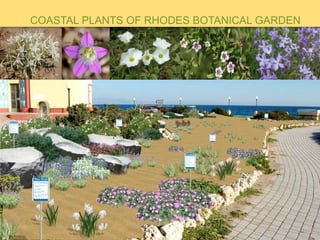
COASTAL PLANTS OF RHODES BOTANICAL GARDEN
- 1. COASTAL PLANTS OF RHODES BOTANICAL GARDEN
- 2. The Aquarium building is situated at the tip of the Northern peninsula of Rhodes island, on a privileged and most appropriate site. It houses the Hydrobiological Station which operates as a Museum and Aquarium and is also used as a research centre. It is surrounded by the ocean on three sides, and it stands alone, at a distance from the city buildings as if rising from the sea. . The park covering this space enhances this sense, since it consists of wide and flat green spaces which were originally planted only with mesymbrianthemum with nothing rising above ground level. Later intervention included planting of lawn and succulents and placement of large rocks.. This planting proved to be unsuccessful since most plants marginally survive, look dry and miserable and some, with their upright form, conflict with the flatness of the site.
- 3. This is an ideal site to create a small botanical garden of the plants that grow on the island’s coast. The plants will thrive and it will complement the function of the Aquarium and Museum of marine life. This is a very interesting group of plants, some of which are rare, some endemic of the island, and some are protected species. Because of the extended mass touristic development of the island most coastal habitats have suffered extended and irreparable damage. Very few intact coastal habitats remain on the island and this posses a threat to many of these unique plants .
- 4. IMPLEMENTATION We must recreate the soil, exposure to the sea and humidity conditions for the plants in a design that is aesthetically pleasing and appropriate to the site. Five distinct zones are created : The first two zones on both sides closest to with sand. They accommodate plants of the sandy dunes with different soil requirements ( especially content) and distance from the strandline, creating The third zone is consisted of rocks and low elevation created by this zone will facilitate the comes with the wind from the beach, stabilizing the The fourth zone is planted with plants of the directly behind the sandy beaches. The fifth zone is planted with plant from the islands torrents and streams.
- 5. 1st Zone: Cakilemaritime Campanularhodensis Pancratiummaritimum Mathiolalongipetala Polygonummaritimum Salsolakali Nigellaarvensissubsp.Brevifolia Consolidaarenaria Ipomeaimperati Dianthuscrinitus 3rd Zone Juniperusoxicedrus subspmacrocarpa Juniperusfoenicea, Lyceumschweinfurtii Eryngiummaritimum Crithmummaritimum Glauciumflavum Atriplexportulacoides Alkanatiktoria Pistacialentiscus Limoniumsinuatum 4th Zone Sarcopoteriumspinosum Helichrysumsp. Cistussp. Fumanathymifollium Coridothymuscapitatus Salviaofficinalis Genistaacanthoclada 5th Zone Vitexagnuscastus Juncusbufonius Lythrum junceum Neriumoleander Phragmitesaustralis SPECIES PER ZONE 2nd Zone : Ononisnatrix Ononisvariegate Otanthusmaritimus Medicagomarina Eryngiummaritimum Campanularhodensis Pancratiummaritimum Lotusperegrines Elymuselongates Cutandiamaritime Elymusfarctus Pseudorlayapumila Glaucium flavum Mesymbrianthemumnodiflorum Hypecoumtorulosum Silenecolorata Convolvulusoleifolius Naupliusaquaticus Limoniumsinuatum Filagocretensissubspcycladum Alyssumborzaenum Verbascumsyriacum Dianthuscrinitus
- 6. THE PLANTS. Juniperus oxycedrus subsp macrocarpa Juniperus foenicea Lycium schweinfurtii Ononis natrix
- 7. Ononis variegate Otanthus maritimus Cakile maritimeMedicago marina
- 8. Eryngium maritimum Campanula rhodensis: Endemic in Rhodes and Chalki Pancratium maritimum Lotus peregrines
- 9. Cutandia maritime Elymus farctus Mathiola longipetala Pseudorlaya pumila
- 10. Polygonum maritimum Crithmum maritimum Salsola kali Glaucium flavum
- 11. Mesymbrianthemum nodiflorum Atriplex portulacoides Hypecoum procumbens ssp. Atropunctatum : Endemic in the eastern Aegean andAsia Minor Hypecoum torulosum Silene colorata
- 12. Alkana tiktoria Convolvulus oleifolius Nauplius aquaticus Limonium sinuatum
- 13. Nigella arvensis subsp. Brevifolia Endemic in Rhodes, Chalki andCrete. Beta vulgaris subsp maritima Ipomea imperati :Rare in Greece Consolida arenaria :Endemic ofthe sand dunes ofSouthern Rhodes. Endangered.
- 14. Filago cretensis subsp cycladum : Rare Verbascum syriacum Endemic in Rhodes andSEAsia Minor Dianthus crinitus: Growson high altitudes at the Atlas mountains (Morocco), Caucasus andother mountains ofcentral Asia. In contrast tothis distribution, it is found in Rhodes on some beaches ofthe east side.