Geomorphology Topic 1 (Part 2) - Basic Concept
•Download as PPT, PDF•
24 likes•8,569 views

The document discusses several key factors that control landform development: 1) Geomorphic agents and processes such as weathering, erosion, and sediment transport affect how rocks and sediment are shaped over time. 2) The types of surficial materials present influences landform evolution. 3) The tectonic setting determines what rock materials are exposed and how they are distributed across the surface. 4) Climate determines the active geologic agents and affects the rates of physical and chemical weathering.

Recommended
More Related Content
What's hot
What's hot (20)
Viewers also liked
Viewers also liked (20)
Similar to Geomorphology Topic 1 (Part 2) - Basic Concept
Similar to Geomorphology Topic 1 (Part 2) - Basic Concept (20)
More from William W. Little
More from William W. Little (20)
Recently uploaded
Recently uploaded (20)
Geomorphology Topic 1 (Part 2) - Basic Concept
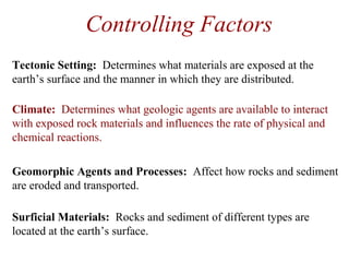
- 1. Controlling Factors Geomorphic Agents and Processes: Affect how rocks and sediment are eroded and transported. Surficial Materials: Rocks and sediment of different types are located at the earth’s surface. Tectonic Setting: Determines what materials are exposed at the earth’s surface and the manner in which they are distributed. Climate: Determines what geologic agents are available to interact with exposed rock materials and influences the rate of physical and chemical reactions.
- 2. Climate Determines what geologic agents are available to interact with exposed rock materials. Influences the rate of physical and chemical reactions.
- 3. • Combination of atmosphere and hydrosphere. • Driven by the Sun and modified by the earth’s rotation. • Responsible for storms, rivers, lakes, groundwater, sand dunes, glaciers, beaches, soil formation, oceanic currents, global circulation patterns, climatic belts, and anything thing else involving water or air. • Whereas, the tectonic system builds things up, the hydrologic system wears them down. • Primary processes include weathering, erosion, sediment transport, deposition, and lithification Hydrologic System From Okanagan University College, Department of Geography website
- 5. States of Matter Matter exists in three forms (states) - solid, liquid, and gas. These represent the ability of atoms to vibrate and move about. The two primary controls are temperature and pressure. An increase in temperature adds energy, causing atoms to vibrate and move further apart, decreasing density. An increase in pressure forces atoms closer together, decreasing their ability to vibrate and increasing density. Atoms are loosely packed and the substance conforms to the shape of its container. Atoms are closely packed and the substance maintains its own shape. From Hamblin & Christiansen (2001) Atoms arecompletely separated and expand to fill all available space.
- 6. Energy Transfer Most energy is transferred from one substance to another through three processes - conduction, convection, and radiation. This transfer can often be measured by changes in temperature. Conduction: Energy is transferred by direct contact as the vibration of atoms on the surface of one material is transmitted to those on the surface of a neighboring material. Convection: Energy is transferred as material moves from place to place due to differences in density, caused mostly by contrasts in temperature. When a material is heated, the atoms move farther apart, density decreases, and it rises. When the material is cooled, atoms move closer together, density increases, and it sinks. Radiation: Energy is transferred through space by electromagnetic waves.
- 7. Global Water Distribution Lakes, streams, ground water, and atmospheric water = 0.65% Oceans = 97.2% Photo by W. W. Little Ice = 2.15% Photo by Global Marine Drilling Photo by W. W. Little Photo by W. W. Little Photo by W. W. LittlePhoto by W. W. Little
- 8. The Sun The Sun is the energy source driving the hydrologic system. Without the Sun, there is no hydrologic system. Photo by NASA
- 9. Earth’s present atmosphere is distinctly different from that of its nearest neighbors, Venus and Mars; although, it is believed that earth’s early atmosphere was similar to that of its neighbors. Atmospheric Compositions
- 10. Because of gravitational attraction, most of earth’s atmosphere is concentrated near the surface in the troposphere, causing both temperature and pressure to be higher at lower altitudes. Atmospheric Pressure & Temperature
- 11. Climatic Belts & Temperature Earth’s surface temperature is greatest at the equator, decreasing to a minimum at the poles.
- 12. Climatic Belts & Precipitation The amount of precipitation that falls is strongly tied to latitude. It is highest at the equator, very low just north and south of the equator, moderate in mid-latitude regions, and lowest at the poles.
- 13. Because of earth’s spheroidal shape, a given amount of solar energy is spread over a larger area at the poles than along the equator. Temperature and the Sun
- 14. Coriollis Effect Earth’s rotation causes an atmospheric deflection that is clockwise in the northern hemisphere and counterclockwise in the southern hemisphere. This creates distinct belts of atmospheric circulation.
- 15. Surface Runoff Stream channels are the most pervasive surface characteristic of earth’s continental masses. They are to earth what craters are to the moon. Photo by NASA
- 16. Streams carry both water and sediment (boulders to dissolved ions) from the land to the sea, where the sediment is ultimately deposited. Photo by W. K. Hamblin Stream Deposition (deltas)
- 17. • Intensity and duration of rainfall. • Prior moisture content of surface material. • Porosity and permeability of surface material. • Gradient • Amount and type of vegetation. • Temperature Runoff Controls
- 18. Surface runoff can be temporarily impounded by lakes and reservoirs. Photo by W. K Hamblin Lakes and Reservoirs
- 19. Glaciers represent a temporary disruption of normal surface runoff. Water is tied up in ice, which flows downhill in much the same manner as rivers but much more slowly. Glaciers
- 20. Deserts Deserts represent a disruption of the river system, which occurs when temperatures are sufficiently high so that the hydrologic system is partially shutoff due to a lack of precipitation. Eolian (wind) processes dominate and river systems can be completely overwhelmed by dune fields. Photo by W. W. Little
- 21. Changing Environments Radar images taken through dune fields of the Sahara Desert by the Space Shuttle reveal a well-developed drainage system. Photos by NASA
- 22. Groundwater System Some precipitation seeps into the ground and flows through the subsurface. It can return to the surface through seeps and springs or flow directly into streams, lakes, or the sea.
- 23. Groundwater dissolves rock and produces karst (dissolved) features, including sink holes and caves. Karst Topography Photo by W. W. Little
- 24. Landslides are typically caused by a high moisture content in surficial materials. Landslides
- 25. • Waves: part of the hydrologic system driven by unequal solar heating (wind). • Tides: part of the hydrologic system driven by lunar gravitational attraction. • Submarine currents: part of the hydrologic system driven by water density contrasts (related to chemistry amd temperature) and earth’s rotation. Shoreline Systems Rocks are eroded and sediment is transported along shorelines by waves, tides, and submarine currents. Photo by W. W. Little
- 26. Seawater is mostly cold, but above freezing. However, a thin layer of warmer water exists at the surface, where it is heated by solar radiation. This is particularly evident at the equator. Temperature of Seawater
- 27. As a result of the Coriollis Effect, ocean surface currents rotate clockwise in the northern hemisphere and counterclockwise in the southern hemisphere. These currents have important climatic implications. Oceanic Surface Currents
- 28. Due to the Coriollis Effect, warm equatorial surface water is transported northward along the U.S. eastern coast and across the Atlantic Ocean toward Europe, affecting climatic conditions on both sides of the Atlantic. Gulf Stream
- 29. Cold, highly saline polar water sinks and moves along the seafloor, then slowly moves upward where it mixes with warmer water of mid and low latitudes. Deep Ocean Circulation
- 30. Oceanic circulation is very slow but over time involves mixing of the entire volume of the sea. Whole Ocean Circulation
- 31. Controlling Factors Geomorphic Agents and Processes: Affect how rocks and sediment are eroded and transported. Surficial Materials: Rocks and sediment of different types are located at the earth’s surface. Tectonic Setting: Determines what materials are exposed at the earth’s surface and the manner in which they are distributed. Climate: Determines what geologic agents are available to interact with exposed rock materials and influences the rate of physical and chemical reactions.
- 32. Geomorphic Agents and Processes • Atmospheric moisture (weathering) • Gravity (mass movement) • Running water (stream erosion, transport & deposition) • Groundwater (dissolution & precipitation) • Flowing ice (glacial erosion, transport & deposition) • Wind (eolian erosion, transport & deposition) • Waves (long-shore erosion, transport & deposition) • Tides (tidal erosion, transport & deposition) Determine how the land is sculpted
- 33. Atmospheric Moisture The amount of moisture in the air and its composition will control the type and degree of chemical weathering affecting material surfaces.
- 34. Gravity Material loosened by weathering tends to be pulled down hill by gravity.
- 35. Running Water Rivers can be thought of as conveyor belts that remove weathered materials and transport them to a depositional basin.
- 36. Groundwater Groundwater can dissolve or precipitate minerals dependent upon temperature and pressure conditions, composition of the material through which the water is flowing, and the type and concentration of dissolved ions in solution.
- 37. Flowing Ice Flowing ice represents a modification of surface runoff due to extremely cold temperatures. Glaciers are highly competent as an erosional agent and sediment transport mechanism and produce many distinctive landforms.
- 38. • Snow accumulates more rapidly than it melts. • As snow reaches a sufficient thickness, it compresses to ice and begins to flow. • Flowing ice scours the underlying bedrock producing a cirque. • As the glacier grows, it extends further down the valley. • Ultimately, a landscape of U-shaped and hanging valleys, horns, aretes, and other features is produced. Alpine Glacial Valleys
- 39. Wind Deserts represent a disruption of surface runoff due to a lack of precipitation. Wind is the least competent mechanism of sediment erosion and transport but is still responsible for the formation of many landforms.
- 40. Waves Waves move sediment along the coast by means of longshore currents. They erode at headlands and deposit in bays, causing a smoothing and straightening of the shoreline.
- 41. Tides Tides move sediment back and forth perpendicular to the coastline. They produce flat depositional surfaces characterized by rippled plains, marshes, and channels with irregular patterns.
- 42. Controlling Factors Geomorphic Agents and Processes: Affect how rocks and sediment are eroded and transported. Surficial Materials: Rocks and sediment of different types are located at the earth’s surface. Tectonic Setting: Determines what materials are exposed at the earth’s surface and the manner in which they are distributed. Climate: Determines what geologic agents are available to interact with exposed rock materials and influences the rate of physical and chemical reactions.
- 43. Surficial Materials Geomorphic features are strongly influenced by the nature of materials exposed at the surface. • Bedrock or sediment • Composition • Stratigraphy
- 44. Landscape Evolution Landscapes evolve toward an equilibrium that reflects a balance between tectonic and hydrologic forces. When changes occur in one of these systems, the landscape adjusts to reflect those changes.
- 46. The Great Unconformity Arizona Missouri Southeastern Canada
- 48. Concepts of Equilibrium Equilibrium means balance. In geomorphology, it refers to no net change, usually in terms of a balance between deposition and erosion, uplift and downcutting, or soil production and removal. • Equilibrium is strived for but seldom achieved. • A change in one part of a system affects all others.
- 49. Fluvial Equilibrium Recent uplift in excess of erosional rates results in a system that is out of equilibrium. Weathering and erosion dominate headland areas with removed material being transported to a depositional basin. As headlands recede, both erosional and depositional rates decrease. If the region remains stable for an extended period, equilibrium, where erosional and depositional rates are equal, might be achieved.
- 50. • Sea level is the ultimate base level • Lakes and reservoirs provide temporary base levels • Changes in sea level can be eustatic or relative • Changes in base level create and destroy accommodation space Base Level Base level is the level below which erosion cannot occur and above which deposition does not take place.
- 51. Graded (Longitudinal) Profile Stream gradient is related to water velocity and the load it can transport. A change in any of these affects the other two. Each can be influenced by factors outside of the stream system, such as base level fluctuations (gradient), precipitation changes (discharge), and sediment character.
- 55. Coastal Equilibrium (Channel Mouths) Deltas represent a “battle” between fluvial and marine (wave & tidal) processes. Delta morphologies are highly influenced by which of these processes dominates.
- 56. Coastal Equilibrium (headlands & bays) Coastal processes work to straighten and smooth shorelines by focusing energy at headlands, with minimal energy within bays. Overall basin size and geometry, composition of coastal materials, and wind characteristics all play a role.
- 57. An open system is one in which both energy and matter cross its boundaries. A closed system allows only energy to enter or exit. Open vs. Closed Systems Open System Closed (nearly) System
- 58. Negative Feedback Systems Negative feedback systems adjust internally to external forces.
- 59. Positive Feedback Systems Positive feedback systems feed upon and ultimately eliminate themselves. External forces enhance (accelerate) internal processes.
- 60. System Complexity Geological systems can be highly complex, with numerous interdependent variables, making modeling extremely difficult.
Editor's Notes
- Conduction Heat energy can be transferred from one substance to another when they are in direct contact. The moving molecules of one material can increase the energy of the molecules of the other. The heat can also travel through a material as one molecule transfers energy to a neighboring one. This type of heat transfer is called conduction. Conduction is mainly seen with solid objects, but it can happen when any materials come into contact, like when warm air is in contact with your skin. Some materials are better conductors of heat than others. For example, metals are a good conductors of heat, while a material like wood isn't. Metal heated on one end will soon be hot on the other end too, while that is not true with a piece of wood. Good conductors of electricity are often good conductors of heat. Since the atoms are closer together, solids conduct heat better than liquids or gasses. This means that two solid materials in contact would transfer heat from one to the other better than a solid in contact with a gas or a gas with a liquid. Convection When a gas or a liquid is heated, hot areas of the material flow and mix with the cool areas. This type of heating is called convection. Forced air heating and air conditioning are examples of heating (or cooling) by convection. This is an effective way of bringing a hot (or cold) fluid to a different area. It transfer heat over a distance faster than by conduction, but ultimately conduction must transfer the heat from the gas to the other object. Radiation A third method to transfer heat is by radiation. A warm or hot object gives off infrared electromagnetic radiation, which can be absorbed in another object, heating it up. Electric heaters with the shiny reflector use radiation to heat. If they add a fan, they use both radiation and confection to heat an area. Transfer of heat by radiation travels at the speed of light and go go great distances, even in a vacuum. We are heated from the Sun through radiation transfer of heat.