Natural Disasters Topic 3 (Plate Tectonics)
•Download as PPTX, PDF•
6 likes•11,426 views

Overview of plate tectonics for a GE-level course in natural disasters.

Recommended
More Related Content
What's hot
What's hot (20)
Viewers also liked
Viewers also liked (20)
Similar to Natural Disasters Topic 3 (Plate Tectonics)
Similar to Natural Disasters Topic 3 (Plate Tectonics) (20)
More from William W. Little
More from William W. Little (20)
Recently uploaded
Recently uploaded (20)
Natural Disasters Topic 3 (Plate Tectonics)
- 2. Tectonic System Plate tectonics is the process by which rock material is moved from within the earth to its surface and, in some cases, back to its interior and by which the lithosphere is broken into a series of plates that move with respect to one another.
- 3. Early Ideas on Earth History • Supernatural Intervention • Shrinking Earth Theory • Continental Drift Theory • Seafloor Spreading Theory • Theory of Plate Tectonics Ideas concerning the earth’s physical development and the nature of destructive processes have changed dramatically through history.
- 4. Supernatural Intervention Throughout most of human history, natural phenomena have been interpreted through myths and legends to be the results of supernatural intervention. • Volcanoes and earthquakes are caused by angry gods. • Fossils were placed by the devil to confuse man. Sawkins et al.
- 5. Photo by W. W. Little Catastrophism vs. Uniformitarianism Early ideas considered geological features, such as mountain ranges, to have been created through sudden, catastrophic, events. Uniformitarianism is the idea that the same physical, chemical, and biological processes operating on and in the earth today were also active in the past and that, therefore, all geological phenomena can be explained as natural occurrences.
- 6. Shrinking Earth Theory • Both the ocean floor and the continents are ancient features and are fixed in their positions. • Mountain ranges formed through crustal contraction during gradual cooling of a molten planetary surface. • Crustal folding and sea-level changes (uplift/subsidence) are due to cooling and contraction of the earth's interior, similar to the wrinkling of dried fruit.
- 7. Theory of Continental Drift • The Theory of Continental Drift is an early predecessor of the Theory of Plate Tectonics and states that all present continental masses were once connected as single land unit called Pangaea. Pangaea subsequently broke apart with each segment drifting to its present location. • The major weakness of the theory was the lack of a plausible driving mechanism to explain why the continents had drifted.
- 8. Abraham Ortelius (1596) • Belgian cartographer • Published a world map based on the maps of many others that became the basis for our modern atlases • Suggested that the Americas had been "torn away from Europe and Africa . . . by earthquakes and floods"
- 9. Francis Bacon (1620) • British statesman and philosopher • Noted that the margins of Africa and South America are so similar that it could be “no mere accidental occurrence”
- 10. Alexander Von Humboldt (1800) • German botanist • Suggested that Africa and South America might at one time have been joined.
- 11. Antonio Snider-Pelligrini (1858) • French • Considered by many to be the first person to seriously promote a fit between the continents (In a book titled: Creation and Its Mysteries Revealed) • Based on continental fit and backed by fossil evidence from North America and Europe • Believed it to have been caused by Noah’s flood (Not plausible scientifically; therefore, did not receive wide support)
- 12. Frank B. Taylor (1908) • American geologist (U.S. Geological Survey) • Presented several lines of evidence which led to the first serious consideration of the theory • Believed that continents were pulled to the earth’s equator by the gravitational attraction of the Moon following its capture.
- 13. Alfred Wegener (1912) German meteorologist First person to make an exhaustive examination and to vigorously promote the concept. • Published a book titled: The Origin of Continents and Oceans (1915). • Evidence included shapes of continents and similarity of fossils between Brazil and Africa. • Drew three maps showing breakup of what he called Pangaea (“all lands”). • Believed that lower density continental rocks plowed through higher density oceanic rocks due to earth’s rotational forces. Theory rejected by most because of no known way in which this could have occurred.
- 14. Evidences for Continental Drift • Match of continental margins • Identical fossils on land masses now separated by oceans • Match of geological structures and rocks across ocean basins • Matching of out of place, environmentally-sensitive features Despite strong physical and biological evidence, the theory of continental drift was rejected by most scientists because there was no plausible mechanism given by which it could have worked.
- 15. Match of Continental Margins Continental margins on opposing coasts across an ocean basin have remarkably similar shapes and fit together like the pieces of a jigsaw puzzle.
- 16. Similar Patterns The pieces of a puzzle must have both matching edges and a matching pattern.
- 17. Fossil Evidence When continents are reassembled into Pangaea, we find a remarkable alignment of fossil remains for organisms of that age. Organisms that developed later do not follow this pattern.
- 18. Climatic Belt Evidence Earth today has climatic belts that vary with latitude. These show a trend of cooling from the equator to the poles and pattern of a humid equatorial region, followed by arid low latitudes, moderately-wet mid latitudes, and arid polar regions. When continents are reassembled into Pangaea, a similar pattern is seen.
- 19. Glacial Evidence Present Configuration Pangaea Reconstructed Ancient glacial deposits are found at the southern end of all southern hemisphere continents. When Pangaea is reassembled, the boundaries of these deposits match and a common center of ice flow is manifest.
- 20. Rock Evidence Rock units of similar type and age line up when continents are reassembled into Pangaea. This alignment has aided in the discovery of important mineral resources across continental boundaries.
- 21. Structural Evidence Structural features, such as ancient mountain ranges, are continuous when continents are reassembled into Pangaea. Present Configuration Pangaea Reconstructed
- 22. Hypothesis Rejected Despite all of the physical and biological evidence, the theory was rejected by most of the scientific community. “Wegener’s hypothesis in general is of the foot-loose type, in that it takes considerable liberty with our globe, and is less bound by restrictions or tied down by awkward, ugly facts than most of its rival theories. Its appeal seems to lie in the fact that it plays a game in which there are few restrictive rules and no sharply drawn code of conduct (R. T. Chamberlain).” “Utter damned rot (W. B. Scott, Pres. of the American Phil. Soc.)!” The reason for the rejection was that there was no conceivable way to make it work.
- 23. Theory of Seafloor Spreading The seafloor is spreading at oceanic ridges and being subducted along deep sea trenches.
- 24. Robert Dietz (1962) Robert Dietz, of the US Coast Guard, proposed the idea of sea-floor spreading in 1962. He also coined the terms lithosphere and asthenosphere.
- 25. Harry Hess (1962) Harry Hess, of Princeton University, proposed mantle convection as the driving mechanism for sea-floor spreading.
- 26. Evidences for Seafloor Spreading • Oceanic ridge system parallel to continents discovered by sonar • Volcanism and earthquakes concentrated along ridge and continent margins • Oceanic crust younger than continental crust • Oceanic crust increases in age away from ridges • Sediment thickness increases away from ridges • Sea mounts become submerged away from ridges • Oceanic crust mostly basaltic and continental crust mostly granitic • Paleomagnetic reversals in bands parallel to ridges • Apparent polar wandering Seafloor spreading provides the mechanism that makes continental drift work. Plate tectonics is the combination of the theories of continental drift and seafloor spreading.
- 27. Oceanic Ridge System Through sonar studies, a large submarine mountain range was found to run along the center of the Atlantic Ocean parallel to the continental margins on either side. Similar features have subsequently been located in other ocean basins.
- 28. Oceanic Ridges & Spreading Rate
- 29. Oceanic Ridges and Volcanism As oceanic crust separates and moves apart, a fissure is produced which becomes filled with basaltic magma, similar to this Hawaiian lava lake.
- 31. Ocean Ridges and Earthquakes Separation of the crust along oceanic ridge systems generates earthquakes. Because of the thinness of oceanic crust, most of these quakes are shallow in nature.
- 32. Drummond Matthews & Fred Vine (1963) Matthew Drummond Fred Vine Drummond Matthews and his graduate student Fred Vine of Cambridge University hypothesized and later confirmed the presence of “stripes” on the ocean floor related to Earth’s magnetic reversals.
- 33. Ocean Ridges and Magnetic Reversals Surveys of the seafloor have revealed a symmetrical pattern of alternating normal and reversed magnetic polarity parallel to oceanic ridges.
- 34. Earth’s Magnetic Field Because of convection within the core, the earth has developed a polarized magnetic field.
- 35. Paleomagnetism Earth’s magnetic properties are recorded by some rocks, permanently recording magnetic conditions at the time of their formation.
- 36. Magnetic Reversals For reasons not yet understood, the earth’s magnetic polarity periodically changes direction.
- 37. Magnetic Reversal Records Volcanic rocks record the polarity of the earth’s magnetic field at the time of their formation, producing the alternating stripes now present on the ocean floor.
- 39. Magnetic Reversal Record and Time As magnetic reversals are easily preserved in igneous rocks, they can be dated and show the same age relationships along all oceanic ridge systems.
- 40. Age of the Ocean Floor Rocks of the ocean floor are much younger than those of the continents. The seafloor is youngest along oceanic ridges and becomes progressively older as it approaches continental margins, where it has a maximum age of about 180 my.
- 41. Apparent Polar Wandering Polarity records from continental masses make it appear as though polar positions have shifted over time and that, until recently, the poles were located at different places for each of the continents. However, as continents are migrated backward toward Pangaea, it becomes clear that it is the continents that have moved and the poles, in reality, have remained stationary.
- 42. Depth of the Ocean As the seafloor moves away from oceanic ridges, it cools, increases in density, and subsides to greater depths. Therefore, the seafloor becomes progressively deeper away from the ridge.
- 43. Seamounts Seamounts are volcanoes located on the seafloor. These often form along an oceanic ridge and become submerged as they are moved away from the ridge.
- 44. Thickness and Age of Sediment Deep sea sediment is derived primarily from the accumulation of animal skeletons and from wind blown dust that originated over continents. As soon as the lava has erupted onto the surface, it begins to be covered by sediment. Therefore, the older the lava flow, the thicker the accumulation of sediment above it and the older the sediment that is in contact with the lava.
- 45. Plate Tectonics & the Scientific Method Observation: The continents fit together like puzzle pieces Hypothesis: A single large continent split and drifted apart Tests: Fossils, mountain ranges, rock types, etc. match; however, lack of a plausible mechanism led to rejection by most New observation: Mid-oceanic ridge Revised hypothesis: The seafloor is spreading. New tests: Paleomagnetism, age of seafloor rocks, sea mounts, etc.
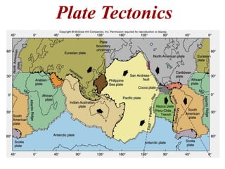
- 46. Plate Tectonic Model The plate tectonic model proposes that new crust is formed at divergent plate boundaries, where plates move away from each other, and is consumed along convergent boundaries, where plates move toward one another. Transform boundaries exist where plates slide laterally past each other, neither producing nor destroying crustal material.
- 47. Plate Movement Plates move at a variety of rates and directions with respect to one another.
- 48. Convection As a material is heated, it expands lowering its density. This causes the material to rise, where it cools, contracts, increases in density, and subsequently sinks.
- 49. Mantle Convection convection cell convection cell Rocks are heated in the mantle, causing them to expand. Expansion lowers density and weakens the rock’s structure. This allows the rock to flow and rise toward the earth’s surface.
- 50. Seiya Uyeda (1994) Seiya Uyeda, a professor at Tokai University in Japan developed the concepts of slab pull and ridge push as mechanisms for plate movement.
- 51. Slab Pull/Ridge Push Coupled with connection, and probably of greater significance in their continued movement is the idea of slab pull and ridge push, in which gravity becomes the primary driver of plate motion.
- 52. Divergent Plate Boundaries Spreading Convection Divergent plate boundaries are locations where the crust is being pulled apart by spreading convection cells. Most divergent boundaries occur on the sea floor and are represented by oceanic ridges; however, they can also form on land as continental rift systems. New crustal material is produced along these boundaries, and they are the sites of frequent shallow focus earthquakes.
- 53. Divergent Boundaries & Earthquakes Earthquakes occur along the entire length of divergent boundaries. Because of the thinness of oceanic crust and thinning of continental crust, these earthquakes are mostly shallow in nature.
- 54. Continental Rift Systems As continental crust is stretched, it becomes thinner and eventually produces an ocean basin. Rift systems are characterized by linear mountain ranges, shallow focus earthquakes, and basaltic volcanism. Over time, the rift system will evolve into an oceanic ridge.
- 55. Early Rift Development Spreading beneath continents pulls the crust apart, forming linear mountain ranges and intervening valleys.
- 56. Basin and Range Structure Mountains and valleys of continental rift systems are bounded by faults. As the crust is stretched, it is thinned by dropping valleys down between the mountain ranges.
- 57. Driggs Graben Jackson Hole Graben Teton Horst
- 58. Basin and Range Province Spreading The Basin and Range Province of the western United States is an example of a continental rift system. This system extends northward from the Gulf of California to northern Idaho and southern Montana.
- 60. Continental Rifts and Volcanism Like oceanic ridges, continental rift zones are characterized by basaltic volcanism. Volcanoes typically occur in a line and can produce flows that spread in layers over wide areas.
- 62. New Ocean Basin Continental rifting eventually leads to the creation of a new ocean basin, as the crust thins and becomes composed primarily of basalt and gabbro.
- 64. Red Sea Rift The Red Sea Rift is an example of a continental rift system that has evolved to a young ocean basin.
- 65. Triple Junction
- 66. From Tarbuck and Lutgens Oceanic Basins Mid-Atlantic Ridge East Pacific Rise Passive Margin Rifting eventually leads to the development of a full ocean basin, including a ridge system running down the center and passive continental shelves along the margin.
- 67. Convergent Plate Boundaries Collision Convection Convergent plate boundaries are locations where the crust is being pushed together by converging convection cells. Most convergent boundaries occur on the sea floor and are represented by oceanic trenches; however, they can also form on land as continental suture zones. Crustal material is consumed along most of these boundaries, and they are sites of frequent shallow, intermediate, and deep focus earthquakes.
- 69. Folded Mountain Belts Collision causes plates to shorten and thicken along their margins. The result is a deep trench produced where the oceanic plate is subducted and an adjacent high mountain belt that forms along the continental margin.
- 71. Convergent Boundaries & Earthquakes Because a subducting plate moves downward beneath the overriding plate, earthquakes become progressively deeper landward of the trench.
- 72. Benioff Zones Progressively deeper earthquakes landward of the deep sea trench support the idea of subduction and is another evidence in favor of the Theory of Plate Tectonics.
- 73. Three Types of Convergent Plate Boundaries Ocean/Ocean Ocean/Continent Continent/Continent
- 74. Ocean/Continent Convergent Boundaries As the subducting plate moves back into the mantle, it begins to melt, producing magma that feeds large composite volcanoes. These volcanoes form in a line parallel to the plate boundary and have highly explosive eruptions of mostly ash.
- 75. Mt. St. Helens
- 78. Ocean/Ocean Convergent Boundaries As with ocean/continent boundaries, one plate subducts beneath the other and begins to melt, producing magma that feeds volcanoes. In this case, the volcanoes form an island chain.
- 81. The Pacific Plate subducts beneath the Asian Plate to form the Kurile Trench and Kurile Islands.
- 82. Continent/Continent Convergent Boundaries Because both plates have a density that is lower than that of the mantle, neither is subducted. Instead, continental plates crush one-another, becoming shorter producing large, highly folded mountain ranges that lack volcanism.
- 83. Formation of Continent/Continent Boundaries Continent/continent convergent plate boundaries are formed as continents converge from opposite sides of an ocean basin. Initially, the boundary will be of ocean/continent character; however, as the basin closes, the continents will collide, eliminating the subduction zone. The collision will produce a high mountain range that parallels the boundary. Due to the lack of a magma source (thick crust and no subduction), there is no active volcanism.
- 84. Collision of India and Asia The collision of India with Asia is responsible for the formation of the Himalayan Mountains, the highest mountain range on earth. Unlike most other major mountain ranges, the Himalayas lack volcanoes.
- 87. Transform Plate Boundaries Transform plate boundaries are locations where plates slip laterally past one another. They receive their name from the fact that they connect other types of plates together and transfer motion between them. While they are characterized by large numbers of earthquakes, they experience little or no volcanic activity. San Andreas Fault System
- 89. Offset Streams Movement on transform faults can offset the path of a stream.
- 91. Transform Fault Basins & Mountains Bends in transform faults lead to extensional and compressional zones along the the fault trace, creating basins and mountain ranges, respectively
- 92. Divergent/Divergent Transform Boundaries These boundaries are common on the sea floor where they separate segments of an oceanic ridge.
- 94. Divergent/Convergent Transform Boundaries These boundaries connect divergent plate boundaries to convergent boundaries, such as the San Andreas Fault that transfers divergent motion from the Gulf of California to convergent motion along the coast of the Pacific Northwest.
- 95. Convergent/Convergent Transform Boundaries This type of boundary connects two convergent plate boundaries, such as the Alpine Fault that crosses New Zealand.
- 96. Hotspots Hotspots occur where plates move over a stationary heat source. This forms a volcanic chain as one volcano moves off of the heat source and another develops above it.
- 98. Mantle Plumes Hotspots are believed to be caused by mantle plumes that originate deep within the mantle and rise to the surface.
- 99. A Problem How do you reconcile these two models?
- 100. Hotspot Volcanic Island Chains As an oceanic plate moves over a hotspot, it leaves a trail of volcanic islands. Only the volcano directly above the plume is active, with other volcanoes of the chain becoming progressively older the further they are from the hotspot.
- 103. Yellowstone Hotspot
- 104. Ash Falls
- 105. Isostatic Adjustment Isostatic adjustment (isostacy) refers to the vertical uplift or subsidence of the crust in response to changes in thickness. As material is added, the crust thickens and sinks further into the mantle. As material is removed by erosion, the crust thins, and material formed at depth rises toward the surface.
- 106. Glaciers and Isostacy Ice bergs are a good example of isostatic adjustment, in that the bulk of the ice is actually present beneath the sea surface. As the exposed portion of the ice melts, the submerged portion rises toward the surface.
- 107. Isostacy and Erosion One of the significant aspects of isostacy is that it brings rocks and structures formed at depth to the surface where they can be observed.