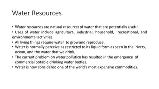
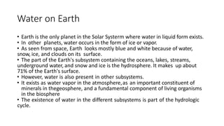
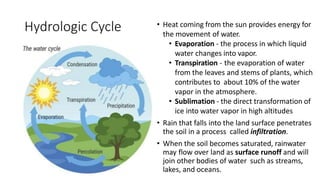
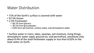
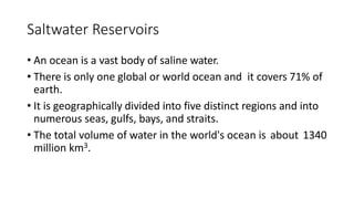
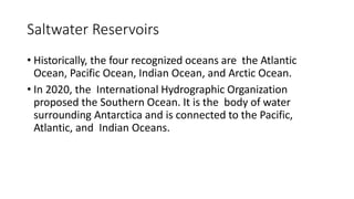
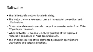
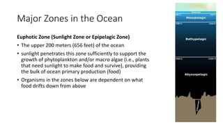
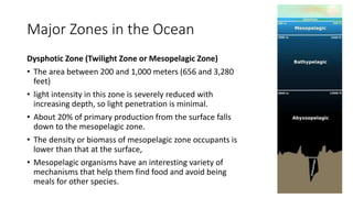
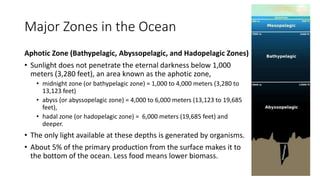
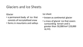
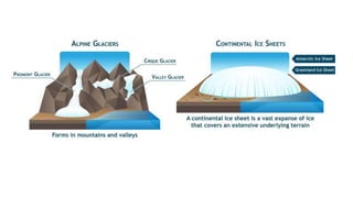
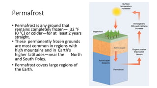
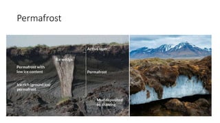
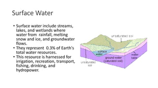
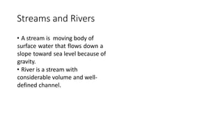
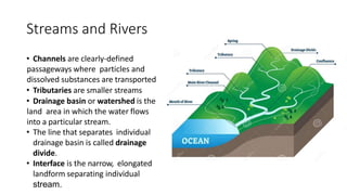
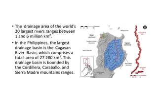
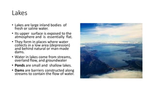
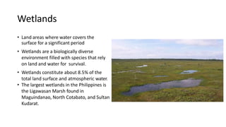
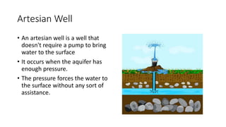
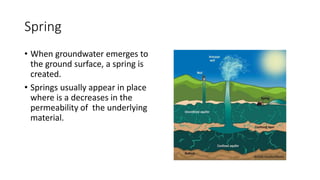
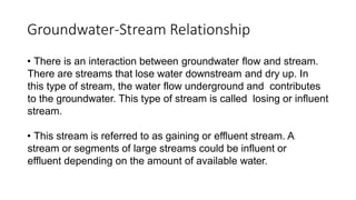
Water Resources
Water
• Water is a simple compound, made of two atoms of hydrogen and
one atom of oxygen bonded together.
• Water is important to life and has remarkable properties.
• Without water, life could probably not even exist on Earth.
• When looking at Earth from space, the abundance of water on Earth
becomes obvious
• On land, water is also common: it swirls and meanders through
streams, falls from the sky, freezes into snow flakes, and even makes
up most of you and me.
Water Resources
• Water resources are natural resources of water that are potentially useful.
• Uses of water include agricultural, industrial, household, recreational, and
environmental activities.
• All living things require water to grow and reproduce.
• Water is normally perceive as restricted to its liquid form as seen in the rivers,
ocean, and the water that we drink.
• The current problem on water pollution has resulted in the emergence of
commercial potable drinking water bottles.
• Water is now considered one of the world's most expensive commodities.
Water on Earth
• Earth is the only planet in the Solar Systerm where water in liquid form exists.
• In other planets, water occurs in the form of ice or vapor.
• As seen from space, Earth looks mostly blue and white because of water,
snow, ice, and clouds on its surface.
• The part of the Earth's subsystem containing the oceans, lakes, streams,
underground water, and snow and ice is the hydrosphere. It makes up about
71% of the Earth's surface.
• However, water is also present in other subsystems.
• It exists as water vapor in the atmosphere,as an important constituent of
minerals in thegeosphere, and a fundamental component of living organisms
in the biosphere
• The existence of water in the different subsystems is part of the hydrologic
cycle.
Hydrologic Cycle
• The water cycle is the movement of water around Earth's surface
and its subsystems. The cycle consists of interconnected pathways
and reservoirs.
• There is a mass balance in the cycle, which maintains the total
amount of water. Fluctuations may occur on a local scale, such as the
occurrence of flood and drought, but these are balanced out on a
global scale.
Hydrologic Cycle • Heat coming from the sun provides energy for
the movement of water.
• Evaporation - the process in which liquid
water changes into vapor.
• Transpiration - the evaporation of water
from the leaves and stems of plants, which
contributes to about 10% of the water
vapor in the atmosphere.
• Sublimation - the direct transformation of
ice into water vapor in high altitudes
• Rain that falls into the land surface penetrates
the soil in a process called infiltration.
• When the soil becomes saturated, rainwater
may flow over land as surface runoff and will
join other bodies of water such as streams,
lakes, and oceans.
Hydrogeology
• The field of geology that deals with the distribution, availability, and
flow of groundwater in aquifers.
• Scientists who specialize in this field are called hydrogeologists.
• They also study groundwater contamination and how it affects the
other subsystems.
Earth’s Water
Earth’s Water
• The total amount of water in the planet, also known as Earth's water
budget, generally remains constant through time.
• Water moves and changes in form but is neither created nor
destroyed.
• Only a very small percentage is added to the hydrologic system by
volcanic eruptions and meteors from space.
• Most of the water on Earth today have been cycling through the
hydrologic system for billions of years.
Water Distribution
• 71% of the Earth’s surface is covered with water
• 97.5% Ocean
• 2.5% Freshwater
• 68.7% from glaciers
• 30.1% from groundwater,
• 0.8% form permafrost, surface water, and atmospheric water
• Surface water in rivers, lakes, swamps, soil moisture, living things,
atmospheric water vapor, ground ice, and permafrost, constitute only
about 0.4% of the total freshwater supply or less than 0.02% or the
total water on Earth.
Saltwater Reservoirs
• An ocean is a vast body of saline water.
• There is only one global or world ocean and it covers 71% of
earth.
• It is geographically divided into five distinct regions and into
numerous seas, gulfs, bays, and straits.
• The total volume of water in the world's ocean is about 1340
million km3.
Saltwater Reservoirs
• Historically, the four recognized oceans are the Atlantic
Ocean, Pacific Ocean, Indian Ocean, and Arctic Ocean.
• In 2020, the International Hydrographic Organization
proposed the Southern Ocean. It is the body of water
surrounding Antarctica and is connected to the Pacific,
Atlantic, and Indian Oceans.
Saltwater
• The saltiness of saltwater is called salinity.
• The major chemical elements present in seawater are sodium and
chlorine ions.
• Other natural elements are also present in seawater varies from 33 to
37 parts per thousand.
• When saltwater is evaporated, three quarters of the dissolved
material is comprised of NaCl (common salt).
• The principal sources of the elements dissolved in seawater are
weathering and volcanic eruptions.
Major Zones in the Ocean
Euphotic Zone (Sunlight Zone or Epipelagic Zone)
• The upper 200 meters (656 feet) of the ocean
• sunlight penetrates this zone sufficiently to support the
growth of phytoplankton and/or macro algae (i.e., plants
that need sunlight to make food and survive), providing
the bulk of ocean primary production (food)
• Organisms in the zones below are dependent on what
food drifts down from above
Major Zones in the Ocean
Dysphotic Zone (Twilight Zone or Mesopelagic Zone)
• The area between 200 and 1,000 meters (656 and 3,280
feet)
• light intensity in this zone is severely reduced with
increasing depth, so light penetration is minimal.
• About 20% of primary production from the surface falls
down to the mesopelagic zone.
• The density or biomass of mesopelagic zone occupants is
lower than that at the surface,
• Mesopelagic organisms have an interesting variety of
mechanisms that help them find food and avoid being
meals for other species.
Major Zones in the Ocean
Aphotic Zone (Bathypelagic, Abyssopelagic, and Hadopelagic Zones)
• Sunlight does not penetrate the eternal darkness below 1,000
meters (3,280 feet), an area known as the aphotic zone,
• midnight zone (or bathypelagic zone) = 1,000 to 4,000 meters (3,280 to
13,123 feet)
• abyss (or abyssopelagic zone) = 4,000 to 6,000 meters (13,123 to 19,685
feet),
• hadal zone (or hadopelagic zone) = 6,000 meters (19,685 feet) and
deeper.
• The only light available at these depths is generated by organisms.
• About 5% of the primary production from the surface makes it to
the bottom of the ocean. Less food means lower biomass.
Freshwater Reservoirs
• Most of the freshwater on Earth is stored in glaciers situated in
inaccessible areas, such as the Polar Regions and High Mountains.
• The readily available freshwater sources are surface water reservoirs
and groundwater reservoir.
Glaciers and Ice Sheets
Glacier
• a permanent body of ice that
consists of recrystallized snow
• forms in mountains and valleys
Ice sheet
• known as continental glacier
• a mass of glacial ice that covers
surrounding terrain and is
greater than 50,000 km2 (19,000
sq mi).
Permafrost
• Permafrost is any ground that
remains completely frozen— 32 °F
(0 °C) or colder—for at least 2 years
straight.
• These permanently frozen grounds
are most common in regions with
high mountains and in Earth's
higher latitudes—near the North
and South Poles.
• Permafrost covers large regions of
the Earth.
Permafrost
Surface Water
• Surface water include streams,
lakes, and wetlands where
water from rainfall, melting
snow and ice, and groundwater
flows.
• They represent 0.3% of Earth's
total water resources.
• This resource is harnessed for
irrigation, recreation, transport,
fishing, drinking, and
hydropower.
Streams and Rivers
• A stream is moving body of
surface water that flows down a
slope toward sea level because of
gravity.
• River is a stream with
considerable volume and well-
defined channel.
Streams and Rivers
• Channels are clearly-defined
passageways where particles and
dissolved substances are transported
• Tributaries are smaller streams
• Drainage basin or watershed is the
land area in which the water flows
into a particular stream.
• The line that separates individual
drainage basin is called drainage
divide.
• Interface is the narrow, elongated
landform separating individual
stream.
• During heavy rain, water moves
downhill through overland flow.
• After a short distance, the water
enters the channels and
becomes stream flows.
• These processes aid the
transport of sediments and
carving of complex patterns
along their course.
• The drainage area of the world’s
20 largest rivers ranges between
1 and 6 million km².
• In the Philippines, the largest
drainage basin is the Cagayan
River Basin, which comprises a
total area of 27 280 km². This
drainage basin is bounded by
the Cordillera, Caraballo, and
Sierra Madre mountains ranges.
Lakes
• Lakes are large inland bodies of
fresh or saline water.
• Its upper surface is exposed to the
atmosphere and is essentially flat.
• They form in places where water
collects in a low area (depression)
and behind natural or man-made
dams.
• Water in lakes come from streams,
overland flow, and groundwater
• Ponds are small and shallow lakes.
• Dams are barriers constructed along
streams to contain the flow of water.
Wetlands
• Land areas where water covers the
surface for a significant period
• Wetlands are a biologically diverse
environment filled with species that rely
on land and water for survival.
• Wetlands constitute about 8.5% of the
total land surface and atmospheric water.
• The largest wetlands in the Philippines is
the Ligawasan Marsh found in
Maguindanao, North Cotabato, and Sultan
Kudarat.
Types of Wetlands
• Marsh is a shallow wetland around lakes stream and ocean where
grasses and reeds are dominant vegetation.
• Swamp is a wetland with lush tress and vegetation found in low-lying
areas beside slow moving rivers.
• Estuary is a partly enclosed coastal body of water where freshwater
from stream meets the saltwater from the sea.
Flood
• Flood is a natural event in which an area that is usually dry is
submerged under water.
• It occurs when the rate of precipitation is higher than the rate in
which it could be absorbed by the ground or carried by streams.
• It can also occur even during dry periods when natural or man-made
reservoirs collapse.
Types of Flood
• Riverine flood occurs when a stream's discharge is greater than the
capacity of the channel, causing the stream to overflow.
• Flashfloods are characterized by intense, high-velocity torrent of
water that occurs in an existing river channel with little to no notice.
• Coastal flooding occurs when water overwhelms in low-lying areas
along the coasts, usually due to severe weather conditions.
• Surface water flood occurs when heavy rainfall creates a flood event
independent of an overflowing stream.
Role of Vegetation in Floods
• Vegetation plays an important role in reducing flood intensity.
• Plants can slow down overland flow, giving the water enough time to
infiltrate the ground.
• Vegetation and plants also decreases the amount of sediments that
could be eroded by surface runoff.
Groundwater
• Groundwater is freshwater found in the rock and soil layers beneath
surface.
• Groundwater is the largest reservoirs of liquid freshwater on Earth.
It constitutes about 30.1% of the total freshwater.
• Water-bearing rock layers, called aquifers, are like a "sponge" that
holds groundwater in tiny cracks, cavities, and pores between
mineral grains.
Groundwater Storage
• Porosity is the total amount of empty pore spaces in the rock. It
determines the amount of groundwater that an aquifer can hold.
• Sand and gravel have high porosity.
• Crystalline basalt and diorite have low porosity.
• The movement of groundwater within the aquifer is also controlled
by the permeability of the material. Permeability is the ability of the
rock or sediments to allow water to pass through it.
Groundwater Profile
• When a well is excavated in the
ground, the first layer
encountered is the moist soil
layer on the surface.
• Beneath this is a zone where the
spaces between the particles
are filled mainly with air called
the zone of aeration or
unsaturated zone.
• The layer beneath the zone of
aeration is the zone of
saturation.
Groundwater Profile
• The boundary between the
zone of aeration and the
zone of saturation is the
water table.
• Directly above the water
table is a layer called
capillary fringe, wherein
groundwater seeps up to fill
the pore spaces in the zone
of aeration via capillary
action.
Aquifer
• A reliable groundwater supply can be
obtained from aquifers with good
porosity and permeability, such as
coarse-grained clastic sedimentary
rocks.
• An aquifer in which the groundwater
is free to rise to its natural level is
called unconfined aquifer.
• In unconfined aquifer, water is
trapped and held down by pressure
between impermeable rocks called
aquiclude.
Artesian Well
• An artesian well is a well that
doesn't require a pump to bring
water to the surface
• It occurs when the aquifer has
enough pressure.
• The pressure forces the water to
the surface without any sort of
assistance.
Spring
• When groundwater emerges to
the ground surface, a spring is
created.
• Springs usually appear in place
where is a decreases in the
permeability of the underlying
material.
Groundwater-Stream Relationship
• There is an interaction between groundwater flow and stream.
There are streams that lose water downstream and dry up. In
this type of stream, the water flow underground and contributes
to the groundwater. This type of stream is called losing or influent
stream.
• This stream is referred to as gaining or effluent stream. A
stream or segments of large streams could be influent or
effluent depending on the amount of available water.
Water as a Resource
Water Resources
• Water resources helps regulate climate
• It shapes earth's surface.
• Water bodies are habitat for humans, animals, plants, and marine
animals.
• Water is very important for agriculture, cleaning, cooking food, and
various activities.
Activities Affecting Water Quality
1. Population growth, particularly in water short regions.
2. Movement of large number of people from the countryside to town
and cities.
3. Demands for greater food security and higher living standards.
4. Increased competition between different uses of water resources.
5. Pollution from factories, cities, and farmland.
Activities Affecting Water Quality
• The degradation of ecosystem is one of the serious threats that occur
due to changes in landscapes, deforestation, conversion of natural
landscapes into farm or residential areas, urban growth, road-
building, and surface mining.
• These activities have led to too much soil and sediments delivered to
streams in the process of sedimentation.
• Mining of certain metals have also caused surface water to become
acidic, producing a discharge called acid mine drainage.
Water Resource Management and Conservation
• Water resource management is the activity of planning, developing,
distributing and managing the optimum use of water resources.
• The decision-making will be even more difficult with the growing
uncertainties of global climate change and the long term impacts of
management actions.

Water Resources.pptx

  • 1.
  • 2.
    Water • Water isa simple compound, made of two atoms of hydrogen and one atom of oxygen bonded together. • Water is important to life and has remarkable properties. • Without water, life could probably not even exist on Earth. • When looking at Earth from space, the abundance of water on Earth becomes obvious • On land, water is also common: it swirls and meanders through streams, falls from the sky, freezes into snow flakes, and even makes up most of you and me.
  • 3.
    Water Resources • Waterresources are natural resources of water that are potentially useful. • Uses of water include agricultural, industrial, household, recreational, and environmental activities. • All living things require water to grow and reproduce. • Water is normally perceive as restricted to its liquid form as seen in the rivers, ocean, and the water that we drink. • The current problem on water pollution has resulted in the emergence of commercial potable drinking water bottles. • Water is now considered one of the world's most expensive commodities.
  • 4.
    Water on Earth •Earth is the only planet in the Solar Systerm where water in liquid form exists. • In other planets, water occurs in the form of ice or vapor. • As seen from space, Earth looks mostly blue and white because of water, snow, ice, and clouds on its surface. • The part of the Earth's subsystem containing the oceans, lakes, streams, underground water, and snow and ice is the hydrosphere. It makes up about 71% of the Earth's surface. • However, water is also present in other subsystems. • It exists as water vapor in the atmosphere,as an important constituent of minerals in thegeosphere, and a fundamental component of living organisms in the biosphere • The existence of water in the different subsystems is part of the hydrologic cycle.
  • 5.
    Hydrologic Cycle • Thewater cycle is the movement of water around Earth's surface and its subsystems. The cycle consists of interconnected pathways and reservoirs. • There is a mass balance in the cycle, which maintains the total amount of water. Fluctuations may occur on a local scale, such as the occurrence of flood and drought, but these are balanced out on a global scale.
  • 6.
    Hydrologic Cycle •Heat coming from the sun provides energy for the movement of water. • Evaporation - the process in which liquid water changes into vapor. • Transpiration - the evaporation of water from the leaves and stems of plants, which contributes to about 10% of the water vapor in the atmosphere. • Sublimation - the direct transformation of ice into water vapor in high altitudes • Rain that falls into the land surface penetrates the soil in a process called infiltration. • When the soil becomes saturated, rainwater may flow over land as surface runoff and will join other bodies of water such as streams, lakes, and oceans.
  • 7.
    Hydrogeology • The fieldof geology that deals with the distribution, availability, and flow of groundwater in aquifers. • Scientists who specialize in this field are called hydrogeologists. • They also study groundwater contamination and how it affects the other subsystems.
  • 8.
  • 9.
    Earth’s Water • Thetotal amount of water in the planet, also known as Earth's water budget, generally remains constant through time. • Water moves and changes in form but is neither created nor destroyed. • Only a very small percentage is added to the hydrologic system by volcanic eruptions and meteors from space. • Most of the water on Earth today have been cycling through the hydrologic system for billions of years.
  • 10.
    Water Distribution • 71%of the Earth’s surface is covered with water • 97.5% Ocean • 2.5% Freshwater • 68.7% from glaciers • 30.1% from groundwater, • 0.8% form permafrost, surface water, and atmospheric water • Surface water in rivers, lakes, swamps, soil moisture, living things, atmospheric water vapor, ground ice, and permafrost, constitute only about 0.4% of the total freshwater supply or less than 0.02% or the total water on Earth.
  • 11.
  • 12.
    Saltwater Reservoirs • Anocean is a vast body of saline water. • There is only one global or world ocean and it covers 71% of earth. • It is geographically divided into five distinct regions and into numerous seas, gulfs, bays, and straits. • The total volume of water in the world's ocean is about 1340 million km3.
  • 13.
    Saltwater Reservoirs • Historically,the four recognized oceans are the Atlantic Ocean, Pacific Ocean, Indian Ocean, and Arctic Ocean. • In 2020, the International Hydrographic Organization proposed the Southern Ocean. It is the body of water surrounding Antarctica and is connected to the Pacific, Atlantic, and Indian Oceans.
  • 14.
    Saltwater • The saltinessof saltwater is called salinity. • The major chemical elements present in seawater are sodium and chlorine ions. • Other natural elements are also present in seawater varies from 33 to 37 parts per thousand. • When saltwater is evaporated, three quarters of the dissolved material is comprised of NaCl (common salt). • The principal sources of the elements dissolved in seawater are weathering and volcanic eruptions.
  • 15.
    Major Zones inthe Ocean Euphotic Zone (Sunlight Zone or Epipelagic Zone) • The upper 200 meters (656 feet) of the ocean • sunlight penetrates this zone sufficiently to support the growth of phytoplankton and/or macro algae (i.e., plants that need sunlight to make food and survive), providing the bulk of ocean primary production (food) • Organisms in the zones below are dependent on what food drifts down from above
  • 16.
    Major Zones inthe Ocean Dysphotic Zone (Twilight Zone or Mesopelagic Zone) • The area between 200 and 1,000 meters (656 and 3,280 feet) • light intensity in this zone is severely reduced with increasing depth, so light penetration is minimal. • About 20% of primary production from the surface falls down to the mesopelagic zone. • The density or biomass of mesopelagic zone occupants is lower than that at the surface, • Mesopelagic organisms have an interesting variety of mechanisms that help them find food and avoid being meals for other species.
  • 17.
    Major Zones inthe Ocean Aphotic Zone (Bathypelagic, Abyssopelagic, and Hadopelagic Zones) • Sunlight does not penetrate the eternal darkness below 1,000 meters (3,280 feet), an area known as the aphotic zone, • midnight zone (or bathypelagic zone) = 1,000 to 4,000 meters (3,280 to 13,123 feet) • abyss (or abyssopelagic zone) = 4,000 to 6,000 meters (13,123 to 19,685 feet), • hadal zone (or hadopelagic zone) = 6,000 meters (19,685 feet) and deeper. • The only light available at these depths is generated by organisms. • About 5% of the primary production from the surface makes it to the bottom of the ocean. Less food means lower biomass.
  • 18.
  • 19.
    Freshwater Reservoirs • Mostof the freshwater on Earth is stored in glaciers situated in inaccessible areas, such as the Polar Regions and High Mountains. • The readily available freshwater sources are surface water reservoirs and groundwater reservoir.
  • 20.
    Glaciers and IceSheets Glacier • a permanent body of ice that consists of recrystallized snow • forms in mountains and valleys Ice sheet • known as continental glacier • a mass of glacial ice that covers surrounding terrain and is greater than 50,000 km2 (19,000 sq mi).
  • 22.
    Permafrost • Permafrost isany ground that remains completely frozen— 32 °F (0 °C) or colder—for at least 2 years straight. • These permanently frozen grounds are most common in regions with high mountains and in Earth's higher latitudes—near the North and South Poles. • Permafrost covers large regions of the Earth.
  • 23.
  • 24.
    Surface Water • Surfacewater include streams, lakes, and wetlands where water from rainfall, melting snow and ice, and groundwater flows. • They represent 0.3% of Earth's total water resources. • This resource is harnessed for irrigation, recreation, transport, fishing, drinking, and hydropower.
  • 25.
    Streams and Rivers •A stream is moving body of surface water that flows down a slope toward sea level because of gravity. • River is a stream with considerable volume and well- defined channel.
  • 26.
    Streams and Rivers •Channels are clearly-defined passageways where particles and dissolved substances are transported • Tributaries are smaller streams • Drainage basin or watershed is the land area in which the water flows into a particular stream. • The line that separates individual drainage basin is called drainage divide. • Interface is the narrow, elongated landform separating individual stream.
  • 27.
    • During heavyrain, water moves downhill through overland flow. • After a short distance, the water enters the channels and becomes stream flows. • These processes aid the transport of sediments and carving of complex patterns along their course.
  • 28.
    • The drainagearea of the world’s 20 largest rivers ranges between 1 and 6 million km². • In the Philippines, the largest drainage basin is the Cagayan River Basin, which comprises a total area of 27 280 km². This drainage basin is bounded by the Cordillera, Caraballo, and Sierra Madre mountains ranges.
  • 29.
    Lakes • Lakes arelarge inland bodies of fresh or saline water. • Its upper surface is exposed to the atmosphere and is essentially flat. • They form in places where water collects in a low area (depression) and behind natural or man-made dams. • Water in lakes come from streams, overland flow, and groundwater • Ponds are small and shallow lakes. • Dams are barriers constructed along streams to contain the flow of water.
  • 30.
    Wetlands • Land areaswhere water covers the surface for a significant period • Wetlands are a biologically diverse environment filled with species that rely on land and water for survival. • Wetlands constitute about 8.5% of the total land surface and atmospheric water. • The largest wetlands in the Philippines is the Ligawasan Marsh found in Maguindanao, North Cotabato, and Sultan Kudarat.
  • 31.
    Types of Wetlands •Marsh is a shallow wetland around lakes stream and ocean where grasses and reeds are dominant vegetation. • Swamp is a wetland with lush tress and vegetation found in low-lying areas beside slow moving rivers. • Estuary is a partly enclosed coastal body of water where freshwater from stream meets the saltwater from the sea.
  • 32.
    Flood • Flood isa natural event in which an area that is usually dry is submerged under water. • It occurs when the rate of precipitation is higher than the rate in which it could be absorbed by the ground or carried by streams. • It can also occur even during dry periods when natural or man-made reservoirs collapse.
  • 33.
    Types of Flood •Riverine flood occurs when a stream's discharge is greater than the capacity of the channel, causing the stream to overflow. • Flashfloods are characterized by intense, high-velocity torrent of water that occurs in an existing river channel with little to no notice. • Coastal flooding occurs when water overwhelms in low-lying areas along the coasts, usually due to severe weather conditions. • Surface water flood occurs when heavy rainfall creates a flood event independent of an overflowing stream.
  • 34.
    Role of Vegetationin Floods • Vegetation plays an important role in reducing flood intensity. • Plants can slow down overland flow, giving the water enough time to infiltrate the ground. • Vegetation and plants also decreases the amount of sediments that could be eroded by surface runoff.
  • 35.
    Groundwater • Groundwater isfreshwater found in the rock and soil layers beneath surface. • Groundwater is the largest reservoirs of liquid freshwater on Earth. It constitutes about 30.1% of the total freshwater. • Water-bearing rock layers, called aquifers, are like a "sponge" that holds groundwater in tiny cracks, cavities, and pores between mineral grains.
  • 36.
    Groundwater Storage • Porosityis the total amount of empty pore spaces in the rock. It determines the amount of groundwater that an aquifer can hold. • Sand and gravel have high porosity. • Crystalline basalt and diorite have low porosity. • The movement of groundwater within the aquifer is also controlled by the permeability of the material. Permeability is the ability of the rock or sediments to allow water to pass through it.
  • 37.
    Groundwater Profile • Whena well is excavated in the ground, the first layer encountered is the moist soil layer on the surface. • Beneath this is a zone where the spaces between the particles are filled mainly with air called the zone of aeration or unsaturated zone. • The layer beneath the zone of aeration is the zone of saturation.
  • 38.
    Groundwater Profile • Theboundary between the zone of aeration and the zone of saturation is the water table. • Directly above the water table is a layer called capillary fringe, wherein groundwater seeps up to fill the pore spaces in the zone of aeration via capillary action.
  • 39.
    Aquifer • A reliablegroundwater supply can be obtained from aquifers with good porosity and permeability, such as coarse-grained clastic sedimentary rocks. • An aquifer in which the groundwater is free to rise to its natural level is called unconfined aquifer. • In unconfined aquifer, water is trapped and held down by pressure between impermeable rocks called aquiclude.
  • 40.
    Artesian Well • Anartesian well is a well that doesn't require a pump to bring water to the surface • It occurs when the aquifer has enough pressure. • The pressure forces the water to the surface without any sort of assistance.
  • 41.
    Spring • When groundwateremerges to the ground surface, a spring is created. • Springs usually appear in place where is a decreases in the permeability of the underlying material.
  • 42.
    Groundwater-Stream Relationship • Thereis an interaction between groundwater flow and stream. There are streams that lose water downstream and dry up. In this type of stream, the water flow underground and contributes to the groundwater. This type of stream is called losing or influent stream. • This stream is referred to as gaining or effluent stream. A stream or segments of large streams could be influent or effluent depending on the amount of available water.
  • 43.
    Water as aResource
  • 44.
    Water Resources • Waterresources helps regulate climate • It shapes earth's surface. • Water bodies are habitat for humans, animals, plants, and marine animals. • Water is very important for agriculture, cleaning, cooking food, and various activities.
  • 45.
    Activities Affecting WaterQuality 1. Population growth, particularly in water short regions. 2. Movement of large number of people from the countryside to town and cities. 3. Demands for greater food security and higher living standards. 4. Increased competition between different uses of water resources. 5. Pollution from factories, cities, and farmland.
  • 46.
    Activities Affecting WaterQuality • The degradation of ecosystem is one of the serious threats that occur due to changes in landscapes, deforestation, conversion of natural landscapes into farm or residential areas, urban growth, road- building, and surface mining. • These activities have led to too much soil and sediments delivered to streams in the process of sedimentation. • Mining of certain metals have also caused surface water to become acidic, producing a discharge called acid mine drainage.
  • 47.
    Water Resource Managementand Conservation • Water resource management is the activity of planning, developing, distributing and managing the optimum use of water resources. • The decision-making will be even more difficult with the growing uncertainties of global climate change and the long term impacts of management actions.