Using globe maps_in_studying_history.
•
1 like•155 views

Globes are models of the Earth that accurately show the shapes and locations of landmasses and bodies of water. They depict lines of latitude and longitude that form a grid system and allow any place on Earth to be precisely located. While globes are accurate, they are not practical to carry or show detail. Map projections, like the Mercator and Robinson, were developed to show the spherical Earth on a flat surface, but inevitably distort some aspects of size, shape, or direction.
Report
Share
Report
Share
Download to read offline

Recommended
Chapter 6 3
Maps are models of Earth's surface presented on paper. Many maps use projections to transfer points and lines from a globe onto paper, which can distort shapes and areas. The Mercator projection maintains correct continent shapes but distorts areas, with the poles appearing larger. The Robinson projection shows accurate shapes and areas with parallel lines of latitude and curved longitude. The Conic projection is used for small area maps like road maps, being most useful for middle latitudes. Geologic maps show rock arrangements and are used for resource extraction. Three-dimensional maps are often computer-generated. Remote sensing uses satellites to collect distance data, like Landsat images of snow cover or forest fires to make maps. GPS uses satellites to calculate exact positions and create
Maps Ppt
Maps represent the three-dimensional Earth on a two-dimensional surface, inevitably introducing some distortion. Different map projections attempt to minimize this distortion in different ways, prioritizing accuracy of shapes, areas, or distances depending on the projection. No single projection can accurately depict the entire globe without compromising some property of geographic accuracy.
Map Projections
The document discusses different types of map projections used to represent the spherical Earth on a flat surface. It describes distortions inherent in all flat map projections and highlights several specific projections including the Mercator, interrupted, Peters, Robinson projections. The key point is that no single projection is perfect and mapmakers must choose one best suited to their specific needs, minimizing important distortions.
Chapter 2:3 Maps
Maps are used to locate places and show distributions of features on Earth's surface. There are different types of map projections that show shapes and sizes of landmasses in different ways. Topographic maps model elevation changes using contour lines and indicate natural and human-made features. Geologic maps show the arrangement and types of rocks at the surface and below.
The geographer’s tools
Geographers use various tools like globes, maps, and technology to study and represent the Earth. Globes provide a whole spherical view but are not portable, while maps can be scaled and transported but become distorted when flattened. Geographers also employ remote sensing techniques involving satellites and aerial photography as well as geographic information systems to collect, store, and analyze spatial data about the Earth's physical and human features.
Reading & interpreting maps notes
This document provides an overview of common map types and key map elements:
1) It describes several common types of maps including general reference maps, projection maps, charting maps, topical maps, and cartograms. It also highlights topographic maps, which show elevation and physical features.
2) It explains basic geographic elements including hemispheres defined by the equator and prime meridian, as well as cardinal directions shown on compasses.
3) It notes that maps use scales to relate distances on maps to actual distances, and that legends provide keys to symbols and colors used on maps.
Ch. 1.2--Geographer's Tools
This document discusses various tools used by geographers. It describes globes as 3D representations of Earth that are not portable, and maps as 2D graphic representations that are portable but distort Earth's surface. It also discusses satellites that provide geographic data, Geographic Information Systems that combine data layers, and GPS systems that transmit locations. The document outlines different types of maps and map projections, including planar, conical, cylindrical, and Mercator projections.
1.2 - The Geographer’s Tools
Maps and globes are tools used to represent the Earth. Globes are three-dimensional and most accurate but not portable, while maps are two-dimensional, portable but have some distortion. Cartographers or mapmakers use surveying techniques like satellites to examine areas and create maps, storing data using geographic information systems.
Maps and GIS
Maps are graphic representations that help spatially understand things, concepts, or events. There are three main types of maps: topographic, thematic, and special maps. A geographic information system (GIS) integrates hardware, software, and data to capture, manage, analyze and display geographically referenced information. Modern cartography, or map making, largely uses computers and GIS technology.
Cartography
This document provides an overview of cartography and mapmaking. It discusses the processes involved, such as data collection, design, and reproduction. It covers the uses and functions of maps, different types of maps and symbols used. It also explains important concepts like map projections and technological changes in the field. The document highlights both the advantages of maps in conveying spatial information efficiently, as well as their limitations in providing complete accuracy.
Geography Handbook
This document provides an introduction to studying geography through maps, globes, graphs, charts, and diagrams. It discusses the essential elements and themes of geography, including location, place, human-environment interaction, movement, and regions. It also explains different types of maps, projections, map symbols and keys, as well as graphs, charts and pictographs used to display geographic data.
Maps as Models of Earth
This document provides an overview of key concepts for understanding topographic maps, including:
- Contour lines connect points of equal elevation and are used to show elevation changes on topographic maps. Contour interval is the difference in elevation between lines.
- Steeper slopes are shown by closer contour line spacing, while more gentle slopes have lines farther apart. Contour lines never cross and have specific shapes depending on terrain features.
- Topographic maps also use symbols, colors, and index contours to represent landforms and elevation information. These maps provide important data for understanding Earth's surface features and elevation.
Cartography lec #4
Cartography is the science and art of map making. Maps are representations of areas of the earth on a flat surface and include titles, scales, legends, and source statements. Scale expresses the ratio between distances on a map and in real life using statements of scale, representative fractions, and linear scales. There are different units of measurement for distances and scales can be small, showing larger areas with less detail, or large, showing smaller areas with more detail. Maps are also classified based on their communicative objectives like reference maps or thematic maps, and by their subject matter and function like cadastral, topographic, soil, weather, and population maps.
Practical work in geography
Gives details about maps, projections,their uses and also about data presentation. Made for students for 11th and 12th standard. Also helpful for competitive examinations. This file is made from NCERT books of class 11th and 12th books titled "Practical work in Geography"
Geological mapping
A map is a representation of Earth's surface that shows spatial relationships between objects by depicting their distance, direction, and size relative to each other on a flat surface. Maps convey information about a specific area and indicate its position relative to other parts of Earth. A geological map specifically shows the distribution and types of rocks and soils in an area. Geological maps are important tools used by geologists to understand Earth's structure and history, locate resources, and identify natural hazards.
History of cartography
This document provides an overview of cartography. It begins with definitions of cartography and discusses the importance and history of maps. The history section outlines some of the earliest maps from ancient civilizations like Babylonia, Egypt, and Greece. It also describes important contributions from figures like Ptolemy, including his world map and map projections. The document emphasizes that cartography has progressed from early conceptual maps to more accurate representations incorporating scientific principles.
Cartography – plotting the world
The document provides an overview of cartography and the key elements involved in mapmaking. It discusses important concepts like map projections, datums, geographic coordinates, and the common elements of maps such as titles, legends, scales, and directional indicators. It also examines different types of map projections including conic, cylindrical, and planar projections; and factors to consider in map design like the target audience, level of detail to include, appropriate use of symbols, colors and labeling. In the end, it shares some examples of excellent maps created by cartographers and acknowledges the sources of information.
Coordinates
This document discusses geographic coordinate systems and map projections. It provides examples of different types of map projections including Mercator, Mollweide, Lambert Conformal, and others. It also discusses how coordinates systems define geographic and projected coordinate references and how datums are used to define coordinate systems.
Class1b
This document provides an introduction to maps, including what maps are, why they are made, and how to read them. It discusses that maps are generalized views of areas seen from above that represent spatial relationships in a concise manner. It also covers map scales, symbols, projections, and how topographic maps specifically show both 2D and 3D features through the use of contour lines.
Tool Time - Maps
The document provides an overview of key concepts related to maps, including their basics and uses, geographic perspectives they provide, scales, essential map elements, different types of thematic maps, and common map projections. It discusses how maps show location, features, and distribution on Earth's surface. It also explains how scale relates to the ratio between distances on a map and in reality, and defines common map projections like cylindrical, planar, conic, and interrupted projections.
Cartography
This document discusses different types of map projections and their tradeoffs in accurately representing the spherical Earth on a flat surface. It provides examples of common projections like Mercator, Robinson, and Peters and explains how they differently distort features like size, shape, and distance to prioritize certain map qualities. Overall, no single projection is perfect, and mapmakers have devised many methods to flatten the globe while minimizing distortions for specific mapping needs.
Geography skills handbook1
This document introduces various geographic tools used to represent spatial information, including globes, maps, and other visual representations. It discusses how globes provide accurate depictions of location but lack detail, while maps show specific areas in greater detail. The document also covers map projections that translate the round earth onto a flat surface, common map elements like scale and keys, and different types of maps and graphs used by geographers.
Map Projection
The document discusses three common types of map projections: Mercator, equal area, and gnomonic. It describes the Mercator projection as a cylindrical projection that accurately shows directions but distorts sizes, especially at the poles. The equal area projection represents areas correctly on the map using a conic projection. While it shows correct landmass sizes, it alters shapes. The document provides details on the characteristics and purposes of each projection type.
Reading a map
Gives a brief overview of maps and globes and their differences. Ideal for 5th Grade. May be used by others also.
Map projection
This document defines map projections and their basic concepts. It discusses that map projections are a means of representing the earth's spherical surface on a flat plane. The key aspects covered are:
- Map projections transform the 3D globe onto a 2D surface through techniques like developing surfaces (cones, cylinders, planes) and projection planes.
- Properties of map projections include accurate representation of areas, distances, directions, and angles, but no single projection can achieve all properties.
- Common classifications of projections include planar, cylindrical, conical based on the projection surface, and equal area, equidistant based on properties maintained.
- Standard parallels and commonly used projections like UTM, polyconic, Lambert conform
Projections and coordinate system
Remote sensing and GIS techniques are useful tools for civil engineering projects. There are several models that can be used to represent the shape of the Earth, including flat, spherical, and ellipsoidal models. The ellipsoidal model is needed for accurate measurements over long distances. A geodetic datum defines the parameters of the reference ellipsoid and the orientation of the coordinate system grid. Common datums include NAD27 and NAD83, and transformations allow conversion between them. Map projections, such as Mercator and UTM, are used to represent the 3D Earth on a 2D surface, inevitably distorting some spatial properties like shape, area, or distance.
What is a map- Introduction to Map Skills Presentation
This document discusses different types of maps and their purposes. It explains that globes show the Earth as seen from space, with continents and oceans, while maps show the Earth on a flat surface so they can be carried. Maps contain elements like titles, legends, compass roses and scales. The document describes political, physical and other types of maps, and how grid systems of latitude and longitude allow precise locations to be identified using coordinates.
Brain
The document discusses the structure and function of the brain. It describes that the brain weighs between 1300-1400g and is made up of around 100 billion neurons. It also outlines the main parts of the brain including the cerebrum, cerebellum, hypothalamus, medulla, and mentions the pituitary gland. The document aims to describe the structure and function of these parts of the brain and locate the sensory and motor strips.
Peace in khyber pakhtunkhwa pakistan
This document discusses the emerging political scenario in the region and its implications for Khyber Pakhtunkhwa province in Pakistan. It explores how regional developments like the withdrawal of NATO from Afghanistan in 2014 and the ongoing conflict in Afghanistan have negatively impacted the socio-economic and political conditions in Khyber Pakhtunkhwa. Internal factors like corruption and poverty, as well as external factors like the war on terror, have exacerbated issues in the province and harmed the agricultural and industrial economy. The future political stability of the region remains uncertain and dependent on resolving the long-standing conflict in Afghanistan.
More Related Content
What's hot
Maps and GIS
Maps are graphic representations that help spatially understand things, concepts, or events. There are three main types of maps: topographic, thematic, and special maps. A geographic information system (GIS) integrates hardware, software, and data to capture, manage, analyze and display geographically referenced information. Modern cartography, or map making, largely uses computers and GIS technology.
Cartography
This document provides an overview of cartography and mapmaking. It discusses the processes involved, such as data collection, design, and reproduction. It covers the uses and functions of maps, different types of maps and symbols used. It also explains important concepts like map projections and technological changes in the field. The document highlights both the advantages of maps in conveying spatial information efficiently, as well as their limitations in providing complete accuracy.
Geography Handbook
This document provides an introduction to studying geography through maps, globes, graphs, charts, and diagrams. It discusses the essential elements and themes of geography, including location, place, human-environment interaction, movement, and regions. It also explains different types of maps, projections, map symbols and keys, as well as graphs, charts and pictographs used to display geographic data.
Maps as Models of Earth
This document provides an overview of key concepts for understanding topographic maps, including:
- Contour lines connect points of equal elevation and are used to show elevation changes on topographic maps. Contour interval is the difference in elevation between lines.
- Steeper slopes are shown by closer contour line spacing, while more gentle slopes have lines farther apart. Contour lines never cross and have specific shapes depending on terrain features.
- Topographic maps also use symbols, colors, and index contours to represent landforms and elevation information. These maps provide important data for understanding Earth's surface features and elevation.
Cartography lec #4
Cartography is the science and art of map making. Maps are representations of areas of the earth on a flat surface and include titles, scales, legends, and source statements. Scale expresses the ratio between distances on a map and in real life using statements of scale, representative fractions, and linear scales. There are different units of measurement for distances and scales can be small, showing larger areas with less detail, or large, showing smaller areas with more detail. Maps are also classified based on their communicative objectives like reference maps or thematic maps, and by their subject matter and function like cadastral, topographic, soil, weather, and population maps.
Practical work in geography
Gives details about maps, projections,their uses and also about data presentation. Made for students for 11th and 12th standard. Also helpful for competitive examinations. This file is made from NCERT books of class 11th and 12th books titled "Practical work in Geography"
Geological mapping
A map is a representation of Earth's surface that shows spatial relationships between objects by depicting their distance, direction, and size relative to each other on a flat surface. Maps convey information about a specific area and indicate its position relative to other parts of Earth. A geological map specifically shows the distribution and types of rocks and soils in an area. Geological maps are important tools used by geologists to understand Earth's structure and history, locate resources, and identify natural hazards.
History of cartography
This document provides an overview of cartography. It begins with definitions of cartography and discusses the importance and history of maps. The history section outlines some of the earliest maps from ancient civilizations like Babylonia, Egypt, and Greece. It also describes important contributions from figures like Ptolemy, including his world map and map projections. The document emphasizes that cartography has progressed from early conceptual maps to more accurate representations incorporating scientific principles.
Cartography – plotting the world
The document provides an overview of cartography and the key elements involved in mapmaking. It discusses important concepts like map projections, datums, geographic coordinates, and the common elements of maps such as titles, legends, scales, and directional indicators. It also examines different types of map projections including conic, cylindrical, and planar projections; and factors to consider in map design like the target audience, level of detail to include, appropriate use of symbols, colors and labeling. In the end, it shares some examples of excellent maps created by cartographers and acknowledges the sources of information.
Coordinates
This document discusses geographic coordinate systems and map projections. It provides examples of different types of map projections including Mercator, Mollweide, Lambert Conformal, and others. It also discusses how coordinates systems define geographic and projected coordinate references and how datums are used to define coordinate systems.
Class1b
This document provides an introduction to maps, including what maps are, why they are made, and how to read them. It discusses that maps are generalized views of areas seen from above that represent spatial relationships in a concise manner. It also covers map scales, symbols, projections, and how topographic maps specifically show both 2D and 3D features through the use of contour lines.
Tool Time - Maps
The document provides an overview of key concepts related to maps, including their basics and uses, geographic perspectives they provide, scales, essential map elements, different types of thematic maps, and common map projections. It discusses how maps show location, features, and distribution on Earth's surface. It also explains how scale relates to the ratio between distances on a map and in reality, and defines common map projections like cylindrical, planar, conic, and interrupted projections.
Cartography
This document discusses different types of map projections and their tradeoffs in accurately representing the spherical Earth on a flat surface. It provides examples of common projections like Mercator, Robinson, and Peters and explains how they differently distort features like size, shape, and distance to prioritize certain map qualities. Overall, no single projection is perfect, and mapmakers have devised many methods to flatten the globe while minimizing distortions for specific mapping needs.
Geography skills handbook1
This document introduces various geographic tools used to represent spatial information, including globes, maps, and other visual representations. It discusses how globes provide accurate depictions of location but lack detail, while maps show specific areas in greater detail. The document also covers map projections that translate the round earth onto a flat surface, common map elements like scale and keys, and different types of maps and graphs used by geographers.
Map Projection
The document discusses three common types of map projections: Mercator, equal area, and gnomonic. It describes the Mercator projection as a cylindrical projection that accurately shows directions but distorts sizes, especially at the poles. The equal area projection represents areas correctly on the map using a conic projection. While it shows correct landmass sizes, it alters shapes. The document provides details on the characteristics and purposes of each projection type.
Reading a map
Gives a brief overview of maps and globes and their differences. Ideal for 5th Grade. May be used by others also.
Map projection
This document defines map projections and their basic concepts. It discusses that map projections are a means of representing the earth's spherical surface on a flat plane. The key aspects covered are:
- Map projections transform the 3D globe onto a 2D surface through techniques like developing surfaces (cones, cylinders, planes) and projection planes.
- Properties of map projections include accurate representation of areas, distances, directions, and angles, but no single projection can achieve all properties.
- Common classifications of projections include planar, cylindrical, conical based on the projection surface, and equal area, equidistant based on properties maintained.
- Standard parallels and commonly used projections like UTM, polyconic, Lambert conform
Projections and coordinate system
Remote sensing and GIS techniques are useful tools for civil engineering projects. There are several models that can be used to represent the shape of the Earth, including flat, spherical, and ellipsoidal models. The ellipsoidal model is needed for accurate measurements over long distances. A geodetic datum defines the parameters of the reference ellipsoid and the orientation of the coordinate system grid. Common datums include NAD27 and NAD83, and transformations allow conversion between them. Map projections, such as Mercator and UTM, are used to represent the 3D Earth on a 2D surface, inevitably distorting some spatial properties like shape, area, or distance.
What is a map- Introduction to Map Skills Presentation
This document discusses different types of maps and their purposes. It explains that globes show the Earth as seen from space, with continents and oceans, while maps show the Earth on a flat surface so they can be carried. Maps contain elements like titles, legends, compass roses and scales. The document describes political, physical and other types of maps, and how grid systems of latitude and longitude allow precise locations to be identified using coordinates.
What's hot (19)
What is a map- Introduction to Map Skills Presentation
What is a map- Introduction to Map Skills Presentation
Viewers also liked
Brain
The document discusses the structure and function of the brain. It describes that the brain weighs between 1300-1400g and is made up of around 100 billion neurons. It also outlines the main parts of the brain including the cerebrum, cerebellum, hypothalamus, medulla, and mentions the pituitary gland. The document aims to describe the structure and function of these parts of the brain and locate the sensory and motor strips.
Peace in khyber pakhtunkhwa pakistan
This document discusses the emerging political scenario in the region and its implications for Khyber Pakhtunkhwa province in Pakistan. It explores how regional developments like the withdrawal of NATO from Afghanistan in 2014 and the ongoing conflict in Afghanistan have negatively impacted the socio-economic and political conditions in Khyber Pakhtunkhwa. Internal factors like corruption and poverty, as well as external factors like the war on terror, have exacerbated issues in the province and harmed the agricultural and industrial economy. The future political stability of the region remains uncertain and dependent on resolving the long-standing conflict in Afghanistan.
Brochure (complete detail as of 12 dec-2010)
This document provides a summary of Zaid Hamid's media activities and publications from 2007-2010. It discusses his defense analysis programs on various TV channels where he discussed issues facing Pakistan such as CIA threats, Zionist wars on Islam, and economic terrorism. It outlines his inspirational speech tours across Pakistan in 2009-2010 that awakened patriotism. The document summarizes Zaid Hamid's role in establishing the think tank BrassTacks and their publications. It provides an overview of his significant media presence and impact in awakening the Pakistani youth.
PROFILE
This profile summarizes the qualifications, experiences, skills, and published works of an individual seeking work as an editor. They have a Bachelor's degree in Political Science, are pursuing a Master's degree in International Relations, and have 9 years of experience as a teacher. For the past 3 years, they have worked as a developmental editor at Danesh Publications where they edit content, verify facts, and work with authors and illustrators. They have strong English and Urdu grammar skills, are proficient with publishing software, and have experience planning and editing textbooks, stories, and articles for various educational publications.
PAKISTAN: PIVOTAL LINK OF CENTRAL EURASIAN MEGA CORRIDOR BY ZAHID ANWAR
The document discusses the Central Eurasian Mega-Corridor project which aims to revive trade routes between Central Asia and South Asia similar to the historic Silk Road. It outlines several infrastructure projects that comprise the corridor, including road, rail, pipeline and fiber optic links between Pakistan, Central Asia, China, and beyond. The corridor would connect resource-rich Central Asian countries to international markets and generate economic development across the region. Pakistan plays a key role in the corridor as it offers connectivity to Arabian Sea ports and its infrastructure upgrades like the Gwadar port and China-Pakistan Economic Corridor reduce distances for regional trade. The realization of the Central Eurasian Mega-Corridor would promote peace, stability
Comprehension
Tigers can be found in cold environments like Siberia where they have thick fur, and in warm places like jungles in India. They hunt alone rather than in packs. Male tigers are larger than females but have the same orange and black striped fur, which helps them camouflage. Tigers rest during the day and hunt at night, preying on deer, wild pigs, and other animals. They creep close before pouncing due to not being fast runners.
Constitutional history of pakistan
The document provides an overview of Pakistan's constitutional history from 1909 to 1973. It discusses several key acts and constitutions:
- The Minto-Marley Reforms of 1909 expanded legislative councils and gave Muslims separate representation.
- The Government of India Act of 1935 established a federal structure and provincial autonomy.
- The 1956 constitution established Pakistan as an Islamic republic with fundamental rights and a parliamentary system.
- The 1962 constitution established a powerful presidential system but centralized power in the presidency.
- The 1973 constitution returned to a parliamentary system with a ceremonial president, bicameral parliament, and protection of fundamental rights and Islamic provisions.
Social media impact on political situation of Pakistan
Social media is having an increasing impact on Pakistani politics. Political parties and leaders like Imran Khan actively use platforms like Facebook and Twitter to engage supporters and criticize opponents. However, social media also faces limitations in Pakistan like limited rural internet access and illiteracy. It can also encourage inappropriate language between political camps. While social media activity is rising, its true influence on elections is still uncertain given most voters remain in rural areas with low connectivity.
Political Parties in Pakistan; A Long Way Ahead
This document discusses political parties in Pakistan and the need for reforms. It notes that while democracy has increased globally over the past few decades, confidence in political parties is declining. In Pakistan specifically, voter turnout has dropped by 21.6% between 1970 and 2002 elections. Political parties have only been in power democratically for 27 of Pakistan's 57 years, and the frequent dismissal of governments and legislatures by military regimes has denied political parties the space to develop. The document calls for reforms at the state, party, and civil society levels to strengthen political parties and democratic governance in Pakistan.
Sun
The document summarizes the different layers of the Sun's atmosphere, including the photosphere, chromosphere, corona, and solar wind. It describes key features of each layer such as their composition, temperature, how they can be observed, and spectral properties. Prominences, solar flares, and aurorae are also briefly discussed in relation to the Sun's magnetic activity and influence on Earth.
South asian history_(visual_inforamtion).
1. Visual charts like timelines, tables, flowcharts, and social pyramids can help summarize and organize key information from history.
2. A timeline shows important events in order, with B.C. dates decreasing and A.D. dates increasing as they near the present.
3. Tables organize information into columns and rows for easy comparison across categories. For example, a table shows the locations, rivers, and emergence times of four early civilizations.
Properties of stars
The document discusses the properties of stars based on their spectra and position on the Hertzsprung-Russell diagram. It describes how stellar spectra can reveal a star's chemical composition and temperature, with Annie Jump Cannon developing the stellar classification system. The Hertzsprung-Russell diagram plots stars based on luminosity and temperature, separating them into main sequence, red giant, supergiant, and white dwarf categories. Relationships between a star's mass, luminosity, radius, and temperature are also explained.
Alstom Swot analysis
This SWOT analysis examines a company's leading market position, comprehensive products, and robust network as strengths, while high staff turnover, slow performance, intense competition, and rising costs of raw materials present weaknesses, opportunities, and threats. New power plants and the positive outlook for renewables present opportunities, while alleged anti-competitive activities are a weakness.
Innovation in governance ppt
This document discusses innovation in governance and public services. It defines different types of innovation and compares innovation in the private and public sectors. The document also outlines three conceptions of governance: traditional public administration, new public management, and networked governance. Each conception pursues innovation differently through the roles of policymakers, public managers, and citizens. While private sector innovation focuses on new technologies and products, public sector innovation faces more limitations and complexity. Further research is needed to understand how context and organizational factors shape the innovation process in public services.
Impact of nato withdrawal on khyber pakhtunkhwa by zahid anwar
The document discusses regional economic integration in South and Central Asia following NATO drawdown from Afghanistan. It outlines challenges faced by Pakistan during the war on terror and opportunities for increased regional connectivity and trade through projects like CASA-1000, TAPI pipeline, China-Pakistan Economic Corridor, and improved infrastructure. Successful regional economic cooperation could help stabilize Afghanistan and bring prosperity to Pakistan and surrounding areas that have suffered from the Afghan conflict.
Impact of Social Media on Political Landscape
The document discusses the significant impact of social media on politics and social movements. It provides examples of how social media helped Barack Obama get elected in 2008 through innovative online strategies. It also describes how social media played a key role in revolutions in Tunisia and Egypt during the Arab Spring uprisings in 2011 by helping spread awareness and organize protests. Further, it outlines how social media was used by the Occupy Wall Street and India Against Corruption movements to connect people and amplify their causes.
Suitable political system for pakistan
The document discusses the current parliamentary system of Pakistan and proposes adopting a presidential system instead. It outlines some disadvantages of the parliamentary system, such as slow decision-making, political instability, and lack of accountability. The proposed presidential system would have a directly-elected president who serves as both head of state and head of government. This would provide clear lines of responsibility, quicker decisions, and prevent military coups. The system would also include an elected legislative body and independent judiciary. Adopting a presidential system could help address Pakistan's political issues by providing stability, accountability, and responsiveness to the will of the people.
Choosing the right political model for pakistan
The only political model that can work in Pakistan which was chosen for us by our ancestors and founding fathers is Khilafat e Rashida, not Democracy.
Stars
The document discusses properties of stars based on observations from Earth. It notes there are over 100 billion stars in the Milky Way galaxy. Stellar parallax is used to measure distances to nearby stars, with the closest being Proxima Centauri at 4.2 light years away. The apparent and absolute magnitudes of stars can be used to determine their intrinsic brightness and distances. A star's color depends on its surface temperature, with hotter stars appearing bluer and cooler stars appearing redder.
Viewers also liked (20)
PAKISTAN: PIVOTAL LINK OF CENTRAL EURASIAN MEGA CORRIDOR BY ZAHID ANWAR
PAKISTAN: PIVOTAL LINK OF CENTRAL EURASIAN MEGA CORRIDOR BY ZAHID ANWAR
Social media impact on political situation of Pakistan
Social media impact on political situation of Pakistan
Impact of nato withdrawal on khyber pakhtunkhwa by zahid anwar
Impact of nato withdrawal on khyber pakhtunkhwa by zahid anwar
Similar to Using globe maps_in_studying_history.
Maps as Models of Earth
This document provides information about key concepts for reading and understanding topographic maps, including:
- Contour lines connect points of equal elevation and are used to show elevation changes on topographic maps. Closer contour lines indicate steeper slopes.
- Relief, elevation difference between highest and lowest points in an area, determines the contour interval or spacing between lines.
- Contour lines have set rules like never crossing, being V-shaped in valleys, and forming closed circles around peaks.
Unit1 160131210057
1. The document discusses the structure and content of a unit on planet Earth and its representation. It will cover topics like the shape and movements of the Earth, coordinates, maps, and time zones.
2. Key concepts that will be explained include the rotation and revolution of the Earth, latitude and longitude, map projections that represent the spherical Earth on a flat surface, and different types of maps and scales.
3. Questions to be answered relate to the position of Earth in the solar system, its movements and seasons, geographic coordinates, representations of Earth, and defining features of maps like scale and time zones. Useful vocabulary is also provided.
Worksheet Science component of earth
This document provides an overview of the key concepts and resources covered in a unit on planet Earth. The unit examines the Earth's position in the solar system, its rotation and revolution, representations of the Earth through maps and models, and the conditions required to support life. Students will learn to interpret maps, understand time zones, and reflect on how technology has changed perceptions of the planet. The unit resources include reinforcement materials, assessments, and audio tracks to support learning about the Earth's movements and geography.
World geography intro powerpoint
Geography is the study of Earth and the relationship between people and their environments. Geographers analyze locations using five themes: location, place, human-environment interaction, movement, and regions. They study physical features like landforms and oceans as well as human aspects such as population and land use. Maps are important tools that help geographers represent Earth's spherical shape on a flat surface, despite some distortion, using techniques like projections and grids. Globes are also used to depict Earth accurately as a round object.
Exploring geographic world
This document provides an overview of geography and geographic concepts. It discusses the definition of geography as the study of the world's environment and human interaction within it. It also outlines key geographic tools like maps and atlases and concepts like the five themes of geography, map projections, grid systems and reading coordinates. The goal is to help readers understand geography and how to make, read and use maps.
Unit 1 wiki
This document provides an overview of key geographic concepts including:
- The Earth's movements and geographic coordinates defined by lines of latitude and longitude that form a grid system.
- Common map projections like Mercator and Peters that translate the spherical Earth onto a flat surface, inevitably distorting aspects of size, shape or area.
- Different types of maps including topographic maps depicting physical features and thematic maps focused on topics like politics, climate or economics.
- Time zones which divide the globe into 24 hourly sections measured at 15 degree intervals based on the Prime Meridian.
RebekahHannonMapSkillsTutorial
Instructional Module intended for first year high schools students for the purpose of refreshing prior map knowledge.
Map Projection
Projecting maps involves converting the spherical earth into a flat plane, which inevitably causes some distortion of properties like angles, areas, directions, and shapes. There are three main types of map projections - cylindrical, conical, and planar - which involve wrapping a lighted globe onto different geometric surfaces like a cylinder, cone, or flat plane. The Mercator projection specifically was created to aid navigation by representing lines of constant bearing as straight lines, though it distorts the relative sizes of land areas farther from the equator. The Universal Transverse Mercator (UTM) system divides the earth into zones and uses the Mercator projection locally in each to assign Cartesian coordinates.
Exploring geography
Geography is the study of the world's environments and human-environment interactions. It has two components: physical geography, which examines the natural world, and human geography, which studies human cultures and activities. Maps are an important tool for geographers, as they can display large amounts of information visually. Different types of maps include political, physical, and thematic maps. Geographers use tools like GIS, aerial photography, and GPS to collect and analyze geographic data and create maps.
Geography.
This document provides an overview of key concepts in geography. It begins by defining geography and its two main divisions: physical geography, which deals with natural environments, and human geography, which examines human-environment interactions. Physical geography includes the study of landforms (geomorphology), oceans (oceanography), climate (climatology), life (biogeography), and the environment. The document then discusses human geography topics like population, urban areas, agriculture, and culture. It also explains concepts like the rotation and revolution of the Earth, which cause seasons, and types of eclipses like lunar and solar eclipses. In the end, it briefly mentions time zones and how local times differ globally.
06 localization
This document discusses techniques for localization and navigation. It begins by describing dead reckoning, which estimates location based on estimated speed, direction and time of travel from a previous location estimate. It then discusses using landmarks for localization by measuring bearings to known landmarks to constrain possible positions. Celestial navigation techniques using stars and chronometers are also summarized. The document emphasizes that localization errors accumulate over time and incorrect data association, such as mistaking one landmark for another, can lead to significant errors in estimated position.
Revision Summary 00 GEO
The document discusses key concepts about maps including:
1) Maps use imaginary lines like latitude and longitude to show locations on Earth's surface.
2) The Earth rotates on its axis and orbits the sun, causing seasons and different amounts of sunlight in each hemisphere.
3) Maps are 2D representations of the 3D Earth, so various projections are used to depict its surface on a flat plane. Scale, symbols, and other elements help readers understand maps.
Catalog of Earth Satellite Orbits_2017
This document provides information about different types of orbits that Earth-observing satellites can have. It describes low Earth orbit, medium Earth orbit, and high Earth orbit, and gives examples of specific orbits within each category, such as polar orbits, sun-synchronous orbits, and Molniya orbits. It also discusses orbital characteristics like height, speed, eccentricity, and inclination that determine a satellite's path. Maintaining the proper orbit is important for satellites to collect desired data and observations of Earth.
Map projection Map and Globe
This document discusses map projections and surveying. It defines a map as a representation of the Earth or part of it on a plane surface with reference to a scale. Key components of maps are identified as the title, scale, direction, grid system, and legend. Different types of maps like physical, political, and thematic maps are described. The differences between maps and globes are outlined. Map projection is defined as the representation of the Earth's graticule on a plan surface. Different properties and classifications of map projections are listed.
World geography
This document provides an overview of key topics in geography including:
1. The two approaches to studying geography - regional and systemic.
2. The origins and formation of Earth over billions of years according to different theories.
3. Details on the structure of Earth's atmosphere from the troposphere to the thermosphere/exosphere and composition of gases.
It concisely covers major concepts in physical geography related to Earth's shape, location systems, motions, seasons, timekeeping and the solar system in 3 sentences or less.
Reading & interpreting maps notes
This document provides an overview of common map types and key map reading concepts:
1) It describes several common types of maps including general reference maps, projection maps, charting maps, topical maps, cartograms, and topographic maps.
2) It explains basic geographic concepts like hemispheres, cardinal directions, compass roses, and how maps use scales to represent distances on Earth.
3) It discusses additional mapping elements like time zones, legends, and how topographic maps use contour lines to indicate elevations.
Maps and globes study guide
This study guide provides questions to help students prepare for a final test on maps and globes. It includes 41 multiple choice questions testing a range of concepts including continental drift theory, map projections, latitude and longitude, hemispheres, directions, and the five themes of geography. Additionally, it notes students must be able to label continents and oceans on a map, use time zone maps, and have a strong understanding of latitude and longitude for the open response question. The open response question will focus on latitude and longitude, including their lines of origin, directions measured, names of lines, and usefulness to people.
Cartography Unit_ 3.pptx
This document provides information on map projections. It defines map projection as a systematic transformation of locations on Earth onto a plane. It discusses the three main types of projections: planar, cylindrical, and conic. Planar projections center on a point and are accurate near the center, cylindrical projections are rolled onto a cylinder and accurate along the equator, and conic projections use a cone and are suited to limited east-west areas near the equator. It also discusses properties like shape, area, direction, and distance distortions that occur in projections and notes no projection is perfect. Common projections like Mercator, UTM, and Robinson are described.
projection
Projections are an essentials part of every datasets. Basically, a projection is the mathematical operation needed to go from the planet actual shape to a flat map according to the Geographic Coordinate System.
Similar to Using globe maps_in_studying_history. (20)
More from EHSAN KHAN
Models of interpretations of statutes
Interpretation is the procedure by which justices interpret and smear lawmaking. Particular quantity of interpretation is frequently essential when a circumstance includes a decree. Occasionally the influences of a decree consume a basic and direct sense. Then in numerous bags, here is specific ambiguity and vagueness in the words of the decree that need be determined by the justice. To novelty the senses of decrees, adjudicators practice many tackles and means of constitutional interpretation, counting outdated norms of legal interpretation, lawmaking antiquity, and determination. In joint law authorities, the law lords may smear rubrics of legislative interpretation together to regulation endorsed by the parliament and to substitute lawmaking such as organizational activity rules.
WHY PAKISTAN WAS CREATED.
The document discusses the reasons for the creation of Pakistan. It outlines the history of British rule in India and the formation of the Muslim League to represent Muslim interests. It describes the Pakistan Movement led by Muhammad Ali Jinnah and the adoption of the Two Nation Theory, which stated that Hindus and Muslims are two separate nations. Key events that strengthened the demand for an independent Muslim state included the Hindi-Urdu controversy, the Lucknow Pact of 1916, the Khilafat Movement, and the 1940 Lahore Resolution passed by the Muslim League. The document examines the role of the Two Nation Theory in the demand for Pakistan and discusses the ideology and objectives for the creation of an independent state for Muslims in the Indian subcontinent.
Ll.b. 315 law of property (mid)
It contains specific provisions regarding what constitutes a transfer and the conditions attached to it. It came into force on 1 July 1882. According to the Act, 'transfer of property' means an act by which a person conveys the property to one or more persons, or himself and one or more other persons.
Ll.b. 314 criminal law i (mid)
The document appears to be a scanned copy of a legal contract for the sale of a residential property. It outlines details of the property such as the address, purchase price, and terms of payment. The contract specifies that the buyer will assume responsibility for property taxes and assessments after the date of closing. It also lists standard contingencies such as the sale being contingent on the buyer obtaining financing.
Ll.b. 313 islamic personal law i (mid)
Muslim Personal Law in India. Muslims in India are governed by The Muslim Personal Law (Shariat) Application Act, 1937. This law deals with marriage, succession, inheritance and charities among Muslims. The Dissolution of Muslim Marriages Act, 1939 deals with the circumstances in which Muslim women can obtain divorce.
Ll.b. 312 constitutional law iii pak (mid)
A constitution is a set of fundamental principles or established precedents according to which a state or other organization is governed. These rules together make up, i.e. constitute, what the entity is.
Ll.b. 311 jurisprudence i (mid)
The document appears to be a scanned copy of a legal contract for the sale of a residential property located in California. It outlines details of the purchase including the purchase price, down payment, financing terms, contingencies and other standard clauses. The buyers and sellers sign at the end to execute the sale of the property.
Concept of marriage in islam
CONCEPT OF MARRIAGE IN ISLAM
Marriage is an integral part of a Muslim’s life, indeed it is too important in our religion Islam that it is considered to be one half of one’s Faith. Islam is not like the other religions that support and promote monasticism or celibacy, but it is a just religion and it takes the middle way in sexual relations, it neither allows it freely, nor does it condemn it like the other certain religions. Marriage is a great virtue and a means of salvation in our religion (Islam). It is our religious duty and a moral safeguard. Marriage is a contract made by male and female to live together as wife and husband and a tie that strengthen their relationship. It is because of this holy tie that families are established in our societies and communities. Moreover, it is the lawful and legitimate way to indulge in intimacy between a man and woman.
Salient feature of 1973 constitution of pakistan
Salient feature of 1973 constitution of Pakistan
Constitution is the set of law and principals that determines the nature, functions and limits of the government and other institutions.
Llb 224 islamic jurisprudence – ii mid.
The word fiqh is an Arabic term meaning "deep understanding" or "full comprehension". Technically it refers to the body of Islamic law extracted from detailed Islamic sources (which are studied in the principles of Islamic jurisprudence) and the process of gaining knowledge of Islam through jurisprudence.
Llb 224 islamic jurisprudence – ii final.
The word fiqh is an Arabic term meaning "deep understanding" or "full comprehension". Technically it refers to the body of Islamic law extracted from detailed Islamic sources (which are studied in the principles of Islamic jurisprudence) and the process of gaining knowledge of Islam through jurisprudence.
Llb 223 law of contract ii mid.
The document discusses a study on the impact of COVID-19 lockdowns on air pollution in China. It notes that nitrogen dioxide levels decreased significantly during the lockdown period compared to previous years, indicating a drop in traffic and industrial activities. However, levels of tiny particulate matter known as PM2.5 did not see as large of a reduction, potentially due to an increase in residential coal burning during winter months when people stayed home. The study highlights how short-term emissions changes during crisis events like lockdowns can provide insights into how different sources contribute to air pollution.
Llb 223 law of contract ii final.
This document outlines the terms and conditions for a rental agreement between John Doe and Jane Doe for the property located at 123 Main St. It specifies the monthly rent amount and due date, the security deposit required, the utilities included, and policies regarding pets, parking, maintenance, and early termination of the lease. The agreement is for a 12-month term beginning January 1, 2023 and ending December 31, 2023.
Llb 225 introduction to psychology mid.
Psychology is the science of the mind and behavior. The word "psychology" comes from the Greek word psyche meaning "breath, spirit, soul", and the Greek word logia meaning the study of something.
According to Medilexicon's medical dictionary, psychology is "The profession (clinical psychology), scholarly discipline (academic psychology), and science (research psychology) concerned with the behavior of humans and animals, and related mental and physiologic processes." Although psychology may also include the study of the mind and behavior of animals, in this article psychology refers to humans.
Llb 225 introduction to psychology final.
Psychology is the science of the mind and behavior. The word "psychology" comes from the Greek word psyche meaning "breath, spirit, soul", and the Greek word logia meaning the study of something.
According to Medilexicon's medical dictionary, psychology is "The profession (clinical psychology), scholarly discipline (academic psychology), and science (research psychology) concerned with the behavior of humans and animals, and related mental and physiologic processes." Although psychology may also include the study of the mind and behavior of animals, in this article psychology refers to humans.
Llb 222 constitutional law (us) mid.
We the People of the United States, in Order to form a more perfect Union, establish Justice, insure domestic Tranquility, provide for the common defence, promote the general Welfare, and secure the Blessings of Liberty to ourselves and our Posterity, do ordain and establish this Constitution for the United States of America.
Llb 222 constitutional law (us) final.
We the People of the United States, in Order to form a more perfect Union, establish Justice, insure domestic Tranquility, provide for the common defence, promote the general Welfare, and secure the Blessings of Liberty to ourselves and our Posterity, do ordain and establish this Constitution for the United States of America.
Human rights law final (ll.b. 221).
Human Rights are the basic rights and freedoms to which all human beings are entitled, like civil and political rights, the right to life and liberty, freedom of thought and speech/expression, equality before the law, social, cultural and economic rights, the right to food, the right to work, and the right to education
Human rights law mid (ll.b. 221).
Human Rights are the basic rights and freedoms to which all human beings are entitled, like civil and political rights, the right to life and liberty, freedom of thought and speech/expression, equality before the law, social, cultural and economic rights, the right to food, the right to work, and the right to education
Formation of Attitude, How it is Changed and Rule of Prejudice
Let's quickly define the word attitude. An attitude is the value a person assigns to something or someone. How do you feel about the current president of the United States? What do you think about classical music? These questions will reveal your level of value towards these things, or, your attitude about the president or classical music.
More from EHSAN KHAN (20)
Formation of Attitude, How it is Changed and Rule of Prejudice
Formation of Attitude, How it is Changed and Rule of Prejudice
Recently uploaded
From Promise to Practice. Implementing AI in Legal Environments
Pim Betist's presentation about generative AI in the legal sector at Lexpo.com '24
一比一原版(Lincoln毕业证)新西兰林肯大学毕业证如何办理
Lincoln硕士毕业证成绩单【微信95270640】办理新西兰林肯大学毕业证原版一模一样、Lincoln毕业证制作【Q微信95270640】《新西兰林肯大学毕业证购买流程》《Lincoln成绩单制作》新西兰林肯大学毕业证书Lincoln毕业证文凭新西兰林肯大学
本科毕业证书,学历学位认证如何办理【留学国外学位学历认证、毕业证、成绩单、大学Offer、雅思托福代考、语言证书、学生卡、高仿教育部认证等一切高仿或者真实可查认证服务】代办国外(海外)英国、加拿大、美国、新西兰、澳大利亚、新西兰等国外各大学毕业证、文凭学历证书、成绩单、学历学位认证真实可查。
[留学文凭学历认证(留信认证使馆认证)新西兰林肯大学毕业证成绩单毕业证证书大学Offer请假条成绩单语言证书国际回国人员证明高仿教育部认证申请学校等一切高仿或者真实可查认证服务。
多年留学服务公司,拥有海外样板无数能完美1:1还原海外各国大学degreeDiplomaTranscripts等毕业材料。海外大学毕业材料都有哪些工艺呢?工艺难度主要由:烫金.钢印.底纹.水印.防伪光标.热敏防伪等等组成。而且我们每天都在更新海外文凭的样板以求所有同学都能享受到完美的品质服务。
国外毕业证学位证成绩单办理方法:
1客户提供办理新西兰林肯大学新西兰林肯大学毕业证学位证信息:姓名生日专业学位毕业时间等(如信息不确定可以咨询顾问:我们有专业老师帮你查询);
2开始安排制作毕业证成绩单电子图;
3毕业证成绩单电子版做好以后发送给您确认;
4毕业证成绩单电子版您确认信息无误之后安排制作成品;
5成品做好拍照或者视频给您确认;
6快递给客户(国内顺丰国外DHLUPS等快读邮寄)
— — — — 我们是挂科和未毕业同学们的福音我们是实体公司精益求精的工艺! — — — -
一真实留信认证的作用(私企外企荣誉的见证):
1:该专业认证可证明留学生真实留学身份同时对留学生所学专业等级给予评定。
2:国家专业人才认证中心颁发入库证书这个入网证书并且可以归档到地方。
3:凡是获得留信网入网的信息将会逐步更新到个人身份内将在公安部网内查询个人身份证信息后同步读取人才网入库信息。
4:个人职称评审加20分个人信誉贷款加10分。
5:在国家人才网主办的全国网络招聘大会中纳入资料供国家500强等高端企业选择人才。问山娃想买什么想吃什么山娃知道父亲赚钱很辛苦除了书籍和文具山娃啥也不要能牵着父亲的手满城闲逛他已心满意足了父亲连挑了三套童装叫山娃试穿山娃有点不想父亲说城里不比乡下要穿得漂漂亮亮爸怎么不穿得漂亮望着父亲山娃反问道父亲听了并不回答只是吃吃地笑山娃很精神越逛越起劲父亲却越逛越疲倦望着父亲呵欠连天的样子山娃也说困了累了回家吧小屋闷罐一般头顶上的三叶扇彻夜呜呜作响搅得满屋热气腾腾也搅得山娃心烦意乱父亲一的
The Future of Criminal Defense Lawyer in India.pdf
https://veteranlegal.in/defense-lawyer-in-india/ | Criminal defense Lawyer in India has always been a vital aspect of the country's legal system. As defenders of justice, criminal Defense Lawyer play a critical role in ensuring that individuals accused of crimes receive a fair trial and that their constitutional rights are protected. As India evolves socially, economically, and technologically, the role and future of criminal Defense Lawyer are also undergoing significant changes. This comprehensive blog explores the current landscape, challenges, technological advancements, and prospects for criminal Defense Lawyer in India.
Incometax Compliance_PF_ ESI- June 2024
This document briefly explains the June compliance calendar 2024 with income tax returns, PF, ESI, and important due dates, forms to be filled out, periods, and who should file them?.
Search Warrants for NH Law Enforcement Officers
Training aid for law enforcement officers related to search warrants, the requirements needed, drafting, and execution of the search warrant.
在线办理(SU毕业证书)美国雪城大学毕业证成绩单一模一样
学校原件一模一样【微信:741003700 】《(SU毕业证书)美国雪城大学毕业证成绩单》【微信:741003700 】学位证,留信认证(真实可查,永久存档)原件一模一样纸张工艺/offer、雅思、外壳等材料/诚信可靠,可直接看成品样本,帮您解决无法毕业带来的各种难题!外壳,原版制作,诚信可靠,可直接看成品样本。行业标杆!精益求精,诚心合作,真诚制作!多年品质 ,按需精细制作,24小时接单,全套进口原装设备。十五年致力于帮助留学生解决难题,包您满意。
本公司拥有海外各大学样板无数,能完美还原。
1:1完美还原海外各大学毕业材料上的工艺:水印,阴影底纹,钢印LOGO烫金烫银,LOGO烫金烫银复合重叠。文字图案浮雕、激光镭射、紫外荧光、温感、复印防伪等防伪工艺。材料咨询办理、认证咨询办理请加学历顾问Q/微741003700
【主营项目】
一.毕业证【q微741003700】成绩单、使馆认证、教育部认证、雅思托福成绩单、学生卡等!
二.真实使馆公证(即留学回国人员证明,不成功不收费)
三.真实教育部学历学位认证(教育部存档!教育部留服网站永久可查)
四.办理各国各大学文凭(一对一专业服务,可全程监控跟踪进度)
如果您处于以下几种情况:
◇在校期间,因各种原因未能顺利毕业……拿不到官方毕业证【q/微741003700】
◇面对父母的压力,希望尽快拿到;
◇不清楚认证流程以及材料该如何准备;
◇回国时间很长,忘记办理;
◇回国马上就要找工作,办给用人单位看;
◇企事业单位必须要求办理的
◇需要报考公务员、购买免税车、落转户口
◇申请留学生创业基金
留信网认证的作用:
1:该专业认证可证明留学生真实身份
2:同时对留学生所学专业登记给予评定
3:国家专业人才认证中心颁发入库证书
4:这个认证书并且可以归档倒地方
5:凡事获得留信网入网的信息将会逐步更新到个人身份内,将在公安局网内查询个人身份证信息后,同步读取人才网入库信息
6:个人职称评审加20分
7:个人信誉贷款加10分
8:在国家人才网主办的国家网络招聘大会中纳入资料,供国家高端企业选择人才
Sangyun Lee, 'Why Korea's Merger Control Occasionally Fails: A Public Choice ...
Presentation slides for a session held on June 4, 2024, at Kyoto University. This presentation is based on the presenter’s recent paper, coauthored with Hwang Lee, Professor, Korea University, with the same title, published in the Journal of Business Administration & Law, Volume 34, No. 2 (April 2024). The paper, written in Korean, is available at <https://shorturl.at/GCWcI>.
What are the common challenges faced by women lawyers working in the legal pr...
The legal profession, which has historically been male-dominated, has experienced a significant increase in the number of women entering the field over the past few decades. Despite this progress, women lawyers continue to encounter various challenges as they strive for top positions.
The Work Permit for Self-Employed Persons in Italy
Learn more on how to obtain the work permit for self-employed persons in Italy at https://immigration-italy.com/selfemployment-work-permit-in-italy/.
Energizing Communities, Fostering Growth, Sustaining Futures
USDA grants bolster rural communities, driving growth, sustainability, and prosperity through strategic development initiatives and financial support.
V.-SENTHIL-BALAJI-SLP-C-8939-8940-2023-SC-Judgment-07-August-2023.pdf
सुप्रीम कोर्ट ने यह भी माना था कि मजिस्ट्रेट का यह कर्तव्य है कि वह सुनिश्चित करे कि अधिकारी पीएमएलए के तहत निर्धारित प्रक्रिया के साथ-साथ संवैधानिक सुरक्षा उपायों का भी उचित रूप से पालन करें।
原版制作(PSU毕业证书)宾州州立大学公园分校毕业证学历证书一模一样
学校原件一模一样【微信:741003700 】《(PSU毕业证书)宾州州立大学公园分校毕业证学历证书》【微信:741003700 】学位证,留信认证(真实可查,永久存档)原件一模一样纸张工艺/offer、雅思、外壳等材料/诚信可靠,可直接看成品样本,帮您解决无法毕业带来的各种难题!外壳,原版制作,诚信可靠,可直接看成品样本。行业标杆!精益求精,诚心合作,真诚制作!多年品质 ,按需精细制作,24小时接单,全套进口原装设备。十五年致力于帮助留学生解决难题,包您满意。
本公司拥有海外各大学样板无数,能完美还原。
1:1完美还原海外各大学毕业材料上的工艺:水印,阴影底纹,钢印LOGO烫金烫银,LOGO烫金烫银复合重叠。文字图案浮雕、激光镭射、紫外荧光、温感、复印防伪等防伪工艺。材料咨询办理、认证咨询办理请加学历顾问Q/微741003700
【主营项目】
一.毕业证【q微741003700】成绩单、使馆认证、教育部认证、雅思托福成绩单、学生卡等!
二.真实使馆公证(即留学回国人员证明,不成功不收费)
三.真实教育部学历学位认证(教育部存档!教育部留服网站永久可查)
四.办理各国各大学文凭(一对一专业服务,可全程监控跟踪进度)
如果您处于以下几种情况:
◇在校期间,因各种原因未能顺利毕业……拿不到官方毕业证【q/微741003700】
◇面对父母的压力,希望尽快拿到;
◇不清楚认证流程以及材料该如何准备;
◇回国时间很长,忘记办理;
◇回国马上就要找工作,办给用人单位看;
◇企事业单位必须要求办理的
◇需要报考公务员、购买免税车、落转户口
◇申请留学生创业基金
留信网认证的作用:
1:该专业认证可证明留学生真实身份
2:同时对留学生所学专业登记给予评定
3:国家专业人才认证中心颁发入库证书
4:这个认证书并且可以归档倒地方
5:凡事获得留信网入网的信息将会逐步更新到个人身份内,将在公安局网内查询个人身份证信息后,同步读取人才网入库信息
6:个人职称评审加20分
7:个人信誉贷款加10分
8:在国家人才网主办的国家网络招聘大会中纳入资料,供国家高端企业选择人才
Synopsis On Annual General Meeting/Extra Ordinary General Meeting With Ordina...
Synopsis On Annual General Meeting/Extra Ordinary General Meeting With Ordina...Syed Muhammad Humza Hussain
Synopsis On Annual General Meeting/Extra Ordinary General Meeting With Ordinary And Special Businesses And Ordinary And Special Resolutions with Companies (Postal Ballot) Regulations, 2018Defending Weapons Offence Charges: Role of Mississauga Criminal Defence Lawyers
Discover how Mississauga criminal defence lawyers defend clients facing weapon offence charges with expert legal guidance and courtroom representation.
To know more visit: https://www.saini-law.com/
Business Laws Sunita saha
Business law for the students of undergraduate level. The presentation contains the summary of all the chapters under the syllabus of State University, Contract Act, Sale of Goods Act, Negotiable Instrument Act, Partnership Act, Limited Liability Act, Consumer Protection Act.
Patenting_Innovations_in_3D_Printing_Prosthetics.pptx
slide deck : Patenting innovations in 3D printing
The Art and Science of Cryptoforensic Investigation: Best Practices and Tools
The Art and Science of Cryptoforensic Investigation: Best Practices and Tools
San Remo Manual on International Law Applicable to Armed Conflict at Sea
Presentation by Justin Ordoyo
University of the Philippines College of Law
Recently uploaded (20)
From Promise to Practice. Implementing AI in Legal Environments
From Promise to Practice. Implementing AI in Legal Environments
The Future of Criminal Defense Lawyer in India.pdf
The Future of Criminal Defense Lawyer in India.pdf
Sangyun Lee, 'Why Korea's Merger Control Occasionally Fails: A Public Choice ...
Sangyun Lee, 'Why Korea's Merger Control Occasionally Fails: A Public Choice ...
What are the common challenges faced by women lawyers working in the legal pr...
What are the common challenges faced by women lawyers working in the legal pr...
The Work Permit for Self-Employed Persons in Italy
The Work Permit for Self-Employed Persons in Italy
Energizing Communities, Fostering Growth, Sustaining Futures
Energizing Communities, Fostering Growth, Sustaining Futures
V.-SENTHIL-BALAJI-SLP-C-8939-8940-2023-SC-Judgment-07-August-2023.pdf
V.-SENTHIL-BALAJI-SLP-C-8939-8940-2023-SC-Judgment-07-August-2023.pdf
Synopsis On Annual General Meeting/Extra Ordinary General Meeting With Ordina...
Synopsis On Annual General Meeting/Extra Ordinary General Meeting With Ordina...
Defending Weapons Offence Charges: Role of Mississauga Criminal Defence Lawyers
Defending Weapons Offence Charges: Role of Mississauga Criminal Defence Lawyers
Patenting_Innovations_in_3D_Printing_Prosthetics.pptx
Patenting_Innovations_in_3D_Printing_Prosthetics.pptx
The Art and Science of Cryptoforensic Investigation: Best Practices and Tools
The Art and Science of Cryptoforensic Investigation: Best Practices and Tools
San Remo Manual on International Law Applicable to Armed Conflict at Sea
San Remo Manual on International Law Applicable to Armed Conflict at Sea
Using globe maps_in_studying_history.
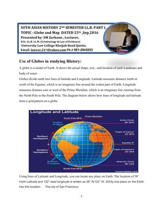
- 1. 1 Use of Globes in studying History: A globe is a model of Earth. It shows the actual shape, size , and location of each Landmass and body of water. Globes divide earth into lines of latitude and Longitude. Latitude measures distance north or south of the Equator, which is an imaginary line around the widest part of Earth. Longitude measures distance east or west of the Prime Meridian, which is an imaginary line running from the North Pole to the South Pole. The diagram below shows how lines of longitude and latitude form a grid pattern on a globe. Using lines of Latitude and Longitude, you can locate any place on Earth. The location of 38° north Latitude and 122° west longitude is written as 38° N/122° W. bOnly one place on the Earth has this location: The city of San Francisco. SOTH ASIAN HISTORY 2ND SEMESTER LL.B. PART I, TOPIC : Globe and Map DATED 25th ,Sep,2016 Presented by: SM Zarkoon , Lecturer, B.Sc. LL.B. LL.M. {Criminology & Law of Evidence} University Law College Khojjak Road Quetta. Email: lawyer.21st@yahoo.com Ph.# 081-2843053
- 2. 2 Exercise Activity: Suppose you wanted a plan to long trip. What would be some advantages and disadvantages of using Globe? __________________________________________________________________ ____________________________________________________________________ ___________________________________________________________________ What is A Map Projection? Globes are accurate, but they are not easy to carry around, and they are not useful for showing areas of Earth in detail. So Mapmakers had to develop methods to show the curved Earth on a flat surface. These methods are known as map projection. All map projections distort Earth in some way. Below are two common types of map projections. A) Mercator Projection: In the 1500s, ocean travelers relied on the Mercator projection, named after mapmaker Gerardus Mercator. The Mercator projection accurately shows direction and the shape of Earth’s landmass. However, it distorts distance and size. B) Robinson Projection:
- 3. 3 The Robinson Projection shows the correct shape and size of landmass for most parts of the world. However, it does not show directions as well as Mercator projection does. It also distorts the size of the North Pole and South Pole. Activity: Would you use a Mercator Projection map to measure the exact distance from Rome to China? Why or Why Not?