This document discusses the use of satellite data for urban development and highway drainage structures in India, emphasizing the importance of infrastructure in developing countries. It details a case study in the Greater Mohali Area, where satellite data helped streamline the design process for a drainage project, resulting in significant time and cost savings. The authors conclude that satellite data can enhance the accuracy and effectiveness of preliminary feasibility studies and project reports.
![International Journal of Engineering Research and Development
e-ISSN: 2278-067X, p-ISSN: 2278-800X, www.ijerd.com
Volume 13, Issue 8 (August 2017), PP.07-12
7
Use of Satellite Data for Feasibility Study And Preliminary
Design Project Report for Urban Development And Highway
Cross Drainage Structures
*
Daljeet Singh1
1
S.D.En. P.W.D. (B&R) Branch, Punjab, India
ABSTRACT: In the developing countries like India, need of infrastructure is very high as compared to the
available resources. The various organizations put their demands to state and center government for sanction of
their project, government depends upon its various department to provide an approximate cost so that priorities
can be assigned. The conventional procedure depends upon the land surveying, collection of data from various
departments resulting in delay in necessary decision making or some time shelving due to unreasonable cost
estimate due to field data being very old. Survey of India, The National Survey and Mapping Organization
single handily taking this responsibility thus up gradation of data is far behind the actual development. From the
satellite data, which is available in the form of images and terrains (even in 3d LiDAR points for some areas) is
very useful for Feasibility Study, and Preliminary Project Report. In the present study natural drain named „Chai
Nala‟ meanders through the prime property of Greater Mohali Area Development Authority (GMADA) thus
making a big chunk of commercial land inoperative. It was proposed to straighten and channelize to reclaim the
land from drain regime. Being the precious land department wanted the most economical and technically sound
design without taking any risk. It was decided to counter check the hydraulic data, ground profile, acquired
from the Punjab Irrigation Department with the satellite data and Differential Global Positioning System
(DGPS). The data from the Google Earth was acquired using Cad Earth software and water shed analysis was
carried out using Autodesk Civil 3D software. Comparison of results shows that this technique is quite useful
and can be for preliminary feasibility and project preparation. Thus saving huge money and time.
Keywords: LiDAR, DGPS, Cad Earth, Civil 3D, Preliminary Project Report, Feasibility Study.
I. INTRODUCTION
Watersheds area can be categorized as gauged and ungauged catchments [1]. Majority of the basins are
either thinly gauged or not gauged at all, where the lack of hydrological and catchment information becomes
hurdle in planning [2]. As per Sing et al. [1], hydrological response from each catchment assists in flood routing
and in flood modeling and flood forecasting. Schumm [3] apprises that water and sediment discharge are the
principal determinants of the dimensions of a river channel and its gradient. Physical characteristics of river
channels, such as width/depth ratio, alignment significantly affected by the flow rate and sediment discharge.
According to Bhatt and Tiwari [2], channel geometry method is an alternative mode of estimating flood
discharge for regional flood frequency analysis. River bed characteristics such s channel width, cross-section
area, river bed gradient, and bank side slope are crucial parameters for alternative techniques of discharge
estimation.
In hydrology, the term “peak discharge” stands for the highest concentration of runoff from the basin
area. The concentrated flow of the basin greatly exaggerated and overtops the natural or artificial bank and this
might be called flood [4]. LiDAR - Light detection and ranging, an effective and productive technology used to
collect accurate terrain data with the help of unmanned aerial vehicle. LiDAR technology evaluates properties of
reflected light to determine type and range of a remote object (Lefsky et al., 2002)[5]. LiDAR systems coupled
with accurate positioning and orientation systems can obtain precise 3D measurements of earth surface in the
form of point cloud data by using high sampling densities (NOAA, 2012)[6]. LiDAR along with very high-
resolution satellite imagery can reduce the time consumption, labor and enhance geographical accessibility to a
significant extent. Display of full-resolution images derived from lidar in the Google Earth virtual globe is a
powerful way to view and explore these data. Through region-dependent network linked Keyhole Markup
Language (KML). Users are able to access LiDAR-derived imagery stored on a remote server from within
Google Earth. This method provides seamless, Internet-based access to imagery through the simple download of
a small KML-format file from the Open Topography Facility portal. This data can further easily analysed with
civil 3D software](https://image.slidesharecdn.com/b1380712-170823084848/75/Use-of-Satellite-Data-for-Feasibility-Study-And-Preliminary-Design-Project-Report-for-Urban-Development-And-Highway-Cross-Drainage-Structures-1-2048.jpg)
![Sample IJERD Paper for A4 Page Size
9
ii. Slope and shape of the catchment area
iii. Porosity of the soil
iv. Obstruction in the flow of water as trees, fields, gardens, etc.
v. Initial state of catchment area with respect to wetness.
vi. Intensity and duration of rainfall
vii. Atmospheric temperature and humidity
viii. Number and size of ditches present in the area
Methods for Estimation of Quantity of Storm Water
1. Rational Method
2. Empirical formulae method
In both the above methods, the quantity of storm water is considered as function of intensity of rainfall,
coefficient of runoff and area of catchment. Time of Concentration: The period after which the entire
catchment area will start contributing to the runoff is called as the time of concentration. The runoff will be
maximum when the duration of rainfall is equal to the time of concentration and is called as critical rainfall
duration.
Time of concentration = Inlet time + time of travel
Inlet Time: The time required for the rain in falling on the most remote point of the tributary area to
flow across the ground surface along the natural drains or gutters up to inlet of sewer is called inlet time (Figure
6.1). The inlet time „Ti‟ can be estimated using relationships similar to following. These coefficients will have
different values for different catchments.
Where,
Ti = [0.885 L3/H]0.385 (1)
Ti = Time of inlet, minute
L = Length of overland flow in Kilometer from critical point to mouth of drain H = Total fall of level from the
critical point to mouth of drain, meter
Time of Travel: The time required by the water to flow in the drain channel from the mouth to the
point under consideration or the point of concentration is called as time of travel.
Time of Travel (Tt) = Length of drain/ velocity in drain (2)
Runoff Coefficient: The total precipitation falling on any area is dispersed as percolation, evaporation, storage in
ponds or reservoir and surface runoff. The runoff coefficient can be defined as a fraction, which is multiplied
with the quantity of total rainfall to determine the quantity of rain water, which will reach the sewers. The runoff
coefficient depends upon the porosity of soil cover, wetness and ground cover. The overall runoff coefficient for
the catchment area can be worked out as follows:
Overall runoff coefficient, C = [A1.C1 + A2.C2 + ….+ An.Cn] / [ A1 + A2 + …+ An] (3)
Where, A1, A2,.An are types of area with C1, C2, …Cn as their coefficient of runoff, respectively.
The range of Coefficient of runoff is normally as under
Type of Cover Coefficient of runoff
Business areas 0.70 – 0.90
Apartment areas 0.50 – 0.70
Single family area 0.30 – 0.50
Parks, Playgrounds, Lawns 0.10 – 0.25
Paved Streets 0.80 –0.90
Water tight roofs 0.70 – 0.95
Storm water quantity can be estimated by rational method as below:
Storm water quantity, Q = C.I.A / 360 (4)
Where,
Q = Quantity of storm water, m3/sec C = Coefficient of runoff
I = intensity of rainfall (mm/hour) for the duration equal to time of concentration, and
A = Drainage area in hectares
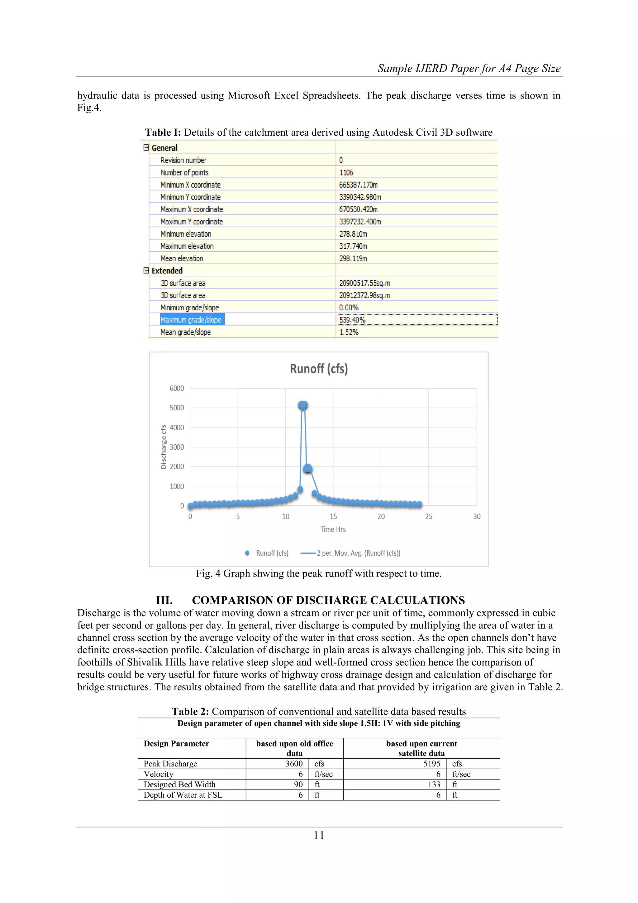
For the verification of the design data and its sufficiency to cater the future needs for at least 50 years, study is
conducted as described below.](https://image.slidesharecdn.com/b1380712-170823084848/75/Use-of-Satellite-Data-for-Feasibility-Study-And-Preliminary-Design-Project-Report-for-Urban-Development-And-Highway-Cross-Drainage-Structures-3-2048.jpg)
![Sample IJERD Paper for A4 Page Size
10
1) Collection of Satellite Data:
The satellite from Google Earth is collected through as per detail procedure described in the Google
Earth Manual, 2007 and Cad Earth Software using Cad Earth 2013 manual, after geo-referencing the drawing.
2) Processing of data:
The downloaded data is exported into any suitable software Mx Road, Civil 3D or Auto Plotter are
various option available in this study Autodesk Civil 3D is used. The data is checked for any discontinuity or
any flaw while transposing from one format to another. The 3D terrain is randomly checked for ground
truthiness, (Rick Ellis 2012) [7]
3) Generating the Catchment Area and Water Drop using Civil 3D software.
The catchment area and water drop analysis with terrain slope and surface runoff coefficient gives the
basic input for calculation of surface runoff if rainfall data is available. The detail procedure is described in
Manual for (Civil 3D 2013) [7].
4) Creating Channel profile using Civil 3D
The channel cross section and longitudinal section are drawn using civil 3D [7] inbuilt features, to find
the channel slope cut and fill depth stability of side slopes can be performed as per the standard procedure.
5) Calculation of Design Discharge and Section Requirement
Fig. 3 (a) Effective catchment area of Chai Nala Fig. 3 (b) Watershed analysis showing water basins
The intensity of rainfall for one hour-storm duration for various return periods was indicated as under:
a. 2 years return period: 43.7 mm/hr. (1.72 inch/hr.)
b. 5 years return period: 58.2 mm/hr. (2.29 inch/hr.)
c. 10 years return period: 63.2 mm/hr. (2.73 inch/hr.)
d. 25 years return period: 83.8 mm/hr. (3.30 inch/hr.)
The characteristics of urban areas are different from rural areas. Due to high concentration of
population and economic activities in urban area the loss to life and property is much higher compare to rural
area. This necessitates a different approach for design of storm water drains in urban areas (NCR Report, 2016)
[8]. The Indian Roads Congress (IRC) brought out guidelines on urban drainage (IRC SP:50 1999) [9]. This
provides guidance for drainage design for roads, but does not provide design information on rainfall intensities
to be adopted for various cities. For example, it mentions that Mumbai drains are being designed for 50 mm/h
and Chennai for 25 mm/h, but does not provide guidelines for future planning for other Indian cities. This will
take into account current international practices, the locations specific factors and rainfall pattern of the cities
and future needs. The adjoining Punjab and Haryana capital city is designed for ½” /hour intensity and presently
the need for up gradation is cropping up. Hence in this study the surface run of 1”/hour is considered. The](https://image.slidesharecdn.com/b1380712-170823084848/75/Use-of-Satellite-Data-for-Feasibility-Study-And-Preliminary-Design-Project-Report-for-Urban-Development-And-Highway-Cross-Drainage-Structures-4-2048.jpg)
![Sample IJERD Paper for A4 Page Size
12
IV. DISCUSSION
The variation in peak runoff and subsequently wider design section of the drain is due to change in the
surface porosity of the catchment area. The weighted average porosity can easily be calculated from the satellite
imagery data. That clearly differentiate between buildings, roads, cultivated farms and green cover of trees and
shrubs thus better calculation of surface runoff is possible. Google earth data can serve good purpose for
preliminary design report and feasibility study of any large scale land development and infrastructures. The
areas where LiDAR enabled satellite data is available, it can be confidently used for detailed project reports also.
The major advantage of this technique that various development agencies can put their future planning in the
form KMZ on Google earth so that other planning agencies can incorporate their implication on project by
simply merging all data in a single platform.
V. CONCLUSION
From the above study the following conclusions are drawn.
1. Satellite data is very useful for preparation of preliminary project report, conducting preliminary feasibility
study, as it involves a fractional time cost as compared to conventional procedure.
2. The data collected are almost current data and brings the higher level of confidence when all the design data
is available from horse‟s mouth.
3. The seamless connectivity of satellite data with other data collected during initial investigations during
project implementation and operations can easily be superimposed on the drawings.
4. The verification of data is very easy as the hand held GPS and even the mobile phone applications are
capable to trace the point on ground very easily.
5. The locations where high accuracy LiDAR enable satellite data is available the accuracy can further be
enhanced to the normal working level.
ACKNOWLEDGEMENT
The author is thankful to the engineers of GMADA, Punjab Irrigation and Consulting Engineers
Associates Panchkula for their contribution without which this study was not possible.
REFERENCES
[1]. A. K. Sing, S. Sharma, and U. Vakharia, “GIS, remote sensing and field measurement for estimating
hydrological parameters in ungauged catchment,” in Proceedings of the 12th Esri India User
Conference, pp. 1–8, 2011.
[2]. V. K. Bhatt and A. K. Tiwari, “Estimation of peak streamflows through channel
geometry,” Hydrological Sciences Journal, vol. 53, no. 2, pp. 401–408, 2008. View at Publisher · View
at Google Scholar · View at Scopus
[3]. S. A. Schumm, “River adjustment to altered hydro-logic regime-Murrumbidgee River and
palaeochannels, Australia,” US Geological Survey Professional Paper 598, 1968. View at Google
Scholar
[4]. J. R. Reddy, A Textbook of Hydrology, University Science Press, New Delhi, India, 2010.
[5]. Lefsky, M.A., Cohen, W.B., Parker G.G., D.J. Harding., 2002. LiDAR remote sensing for ecosystem
studies. Bio Science, 52(1), pp. 19–3.
[6]. National Oceanic and Atmospheric Administration (NOAA) Coastal Services Centre. 2012. LiDAR
101: An Introduction to LiDAR Technology, Data, and Applications. Revised. Charleston, SC: NOAA
Coastal Services Centre.
[7]. Rick Ellis (2012) A Practical Guide to AutoCAD Civil 3D 2013, Published in the United States of
America by Cadapult Software Solutions (503) 829-8929 ISBN: 978-1-934865-10-1
[8]. Functional Plan for Economic Development of. National ... (Approved in the 65th Meeting of the
Planning Committee of NCR. Planning Board held on 28th April, 2016)
[9]. IRC SP 050 (2013), Guidelines on Urban Drainage (First Revision), Published by Indian Road
Congress, New Delhi.
*
Daljeet Singh1. "Use of Satellite Data for Feasibility Study And Preliminary Design Project Report for
Urban Development And Highway Cross Drainage Structures." International Journal of Engineering
Research and Development 13.8 (2017): 07-12.
Welcome to International Journal of Engineering Research and Development (IJERD) with Sl. No.
4739, Journal no. 48012.](https://image.slidesharecdn.com/b1380712-170823084848/75/Use-of-Satellite-Data-for-Feasibility-Study-And-Preliminary-Design-Project-Report-for-Urban-Development-And-Highway-Cross-Drainage-Structures-6-2048.jpg)


![History of surveying [world]](https://cdn.slidesharecdn.com/ss_thumbnails/historyofsurveying-world-170131054131-thumbnail.jpg?width=640&height=640&fit=bounds)