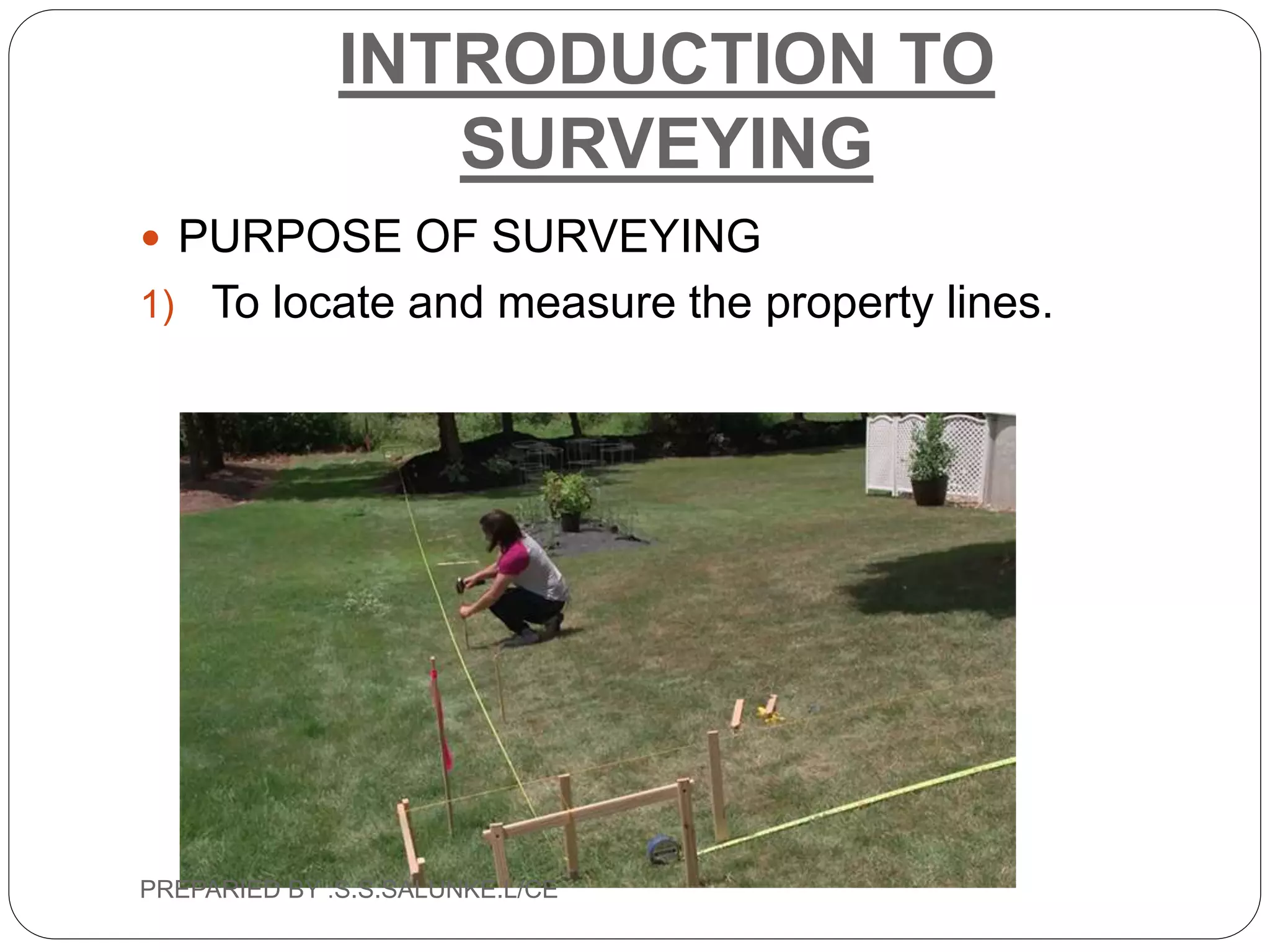
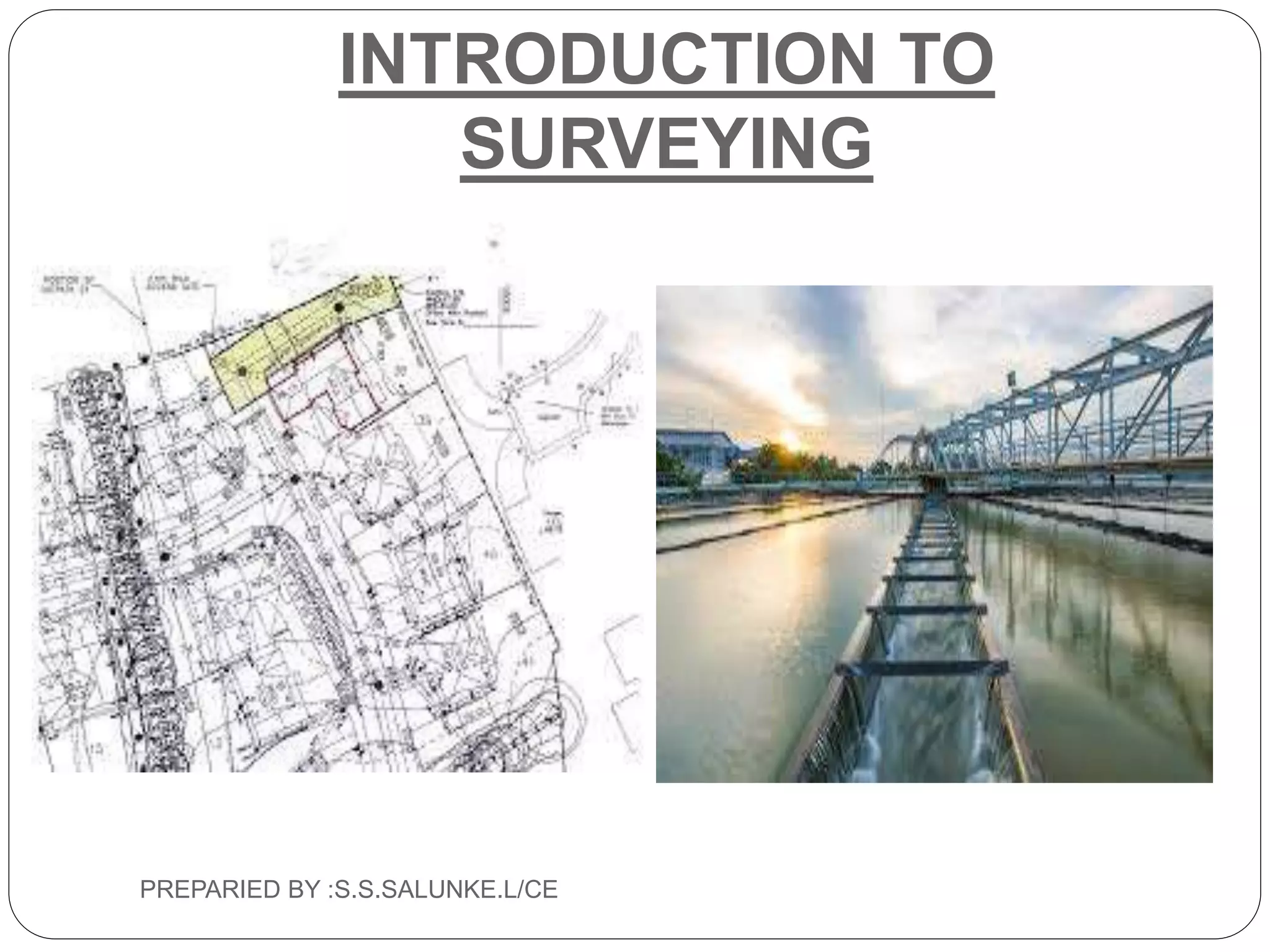
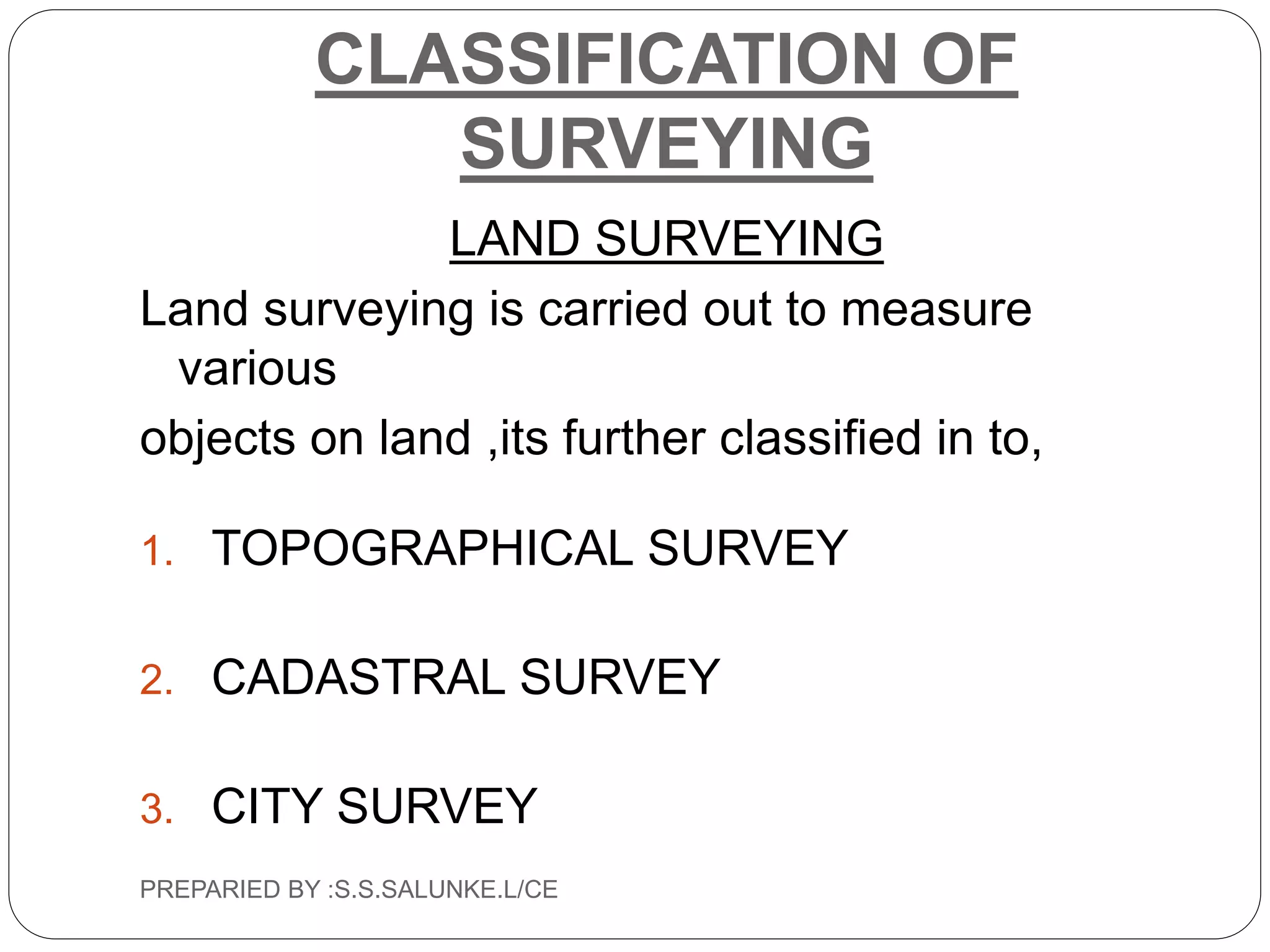
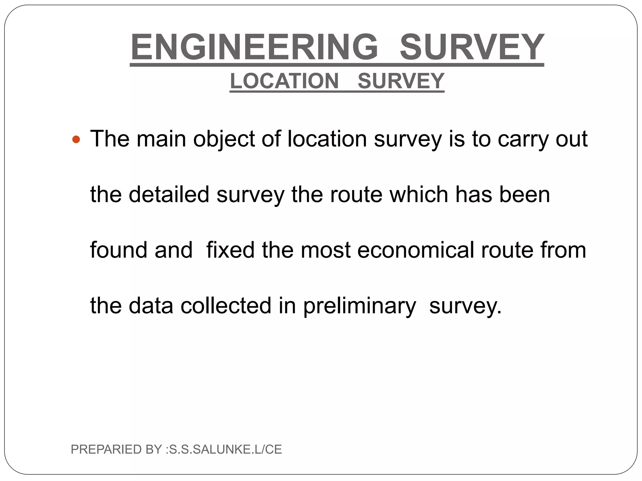
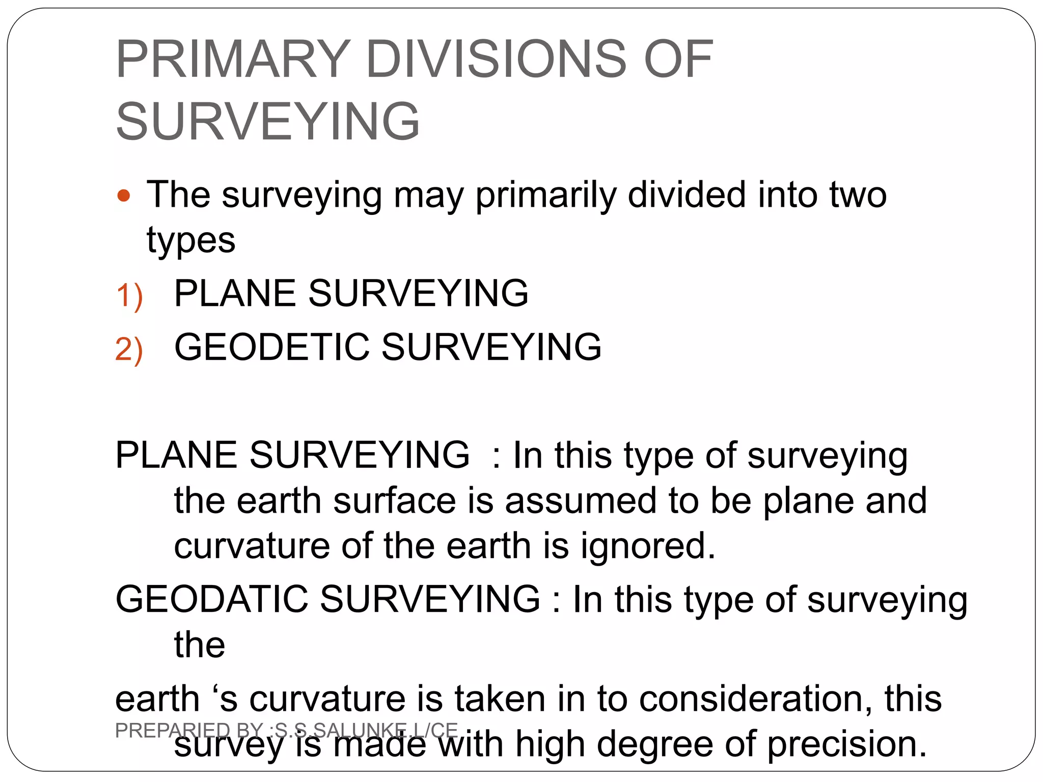
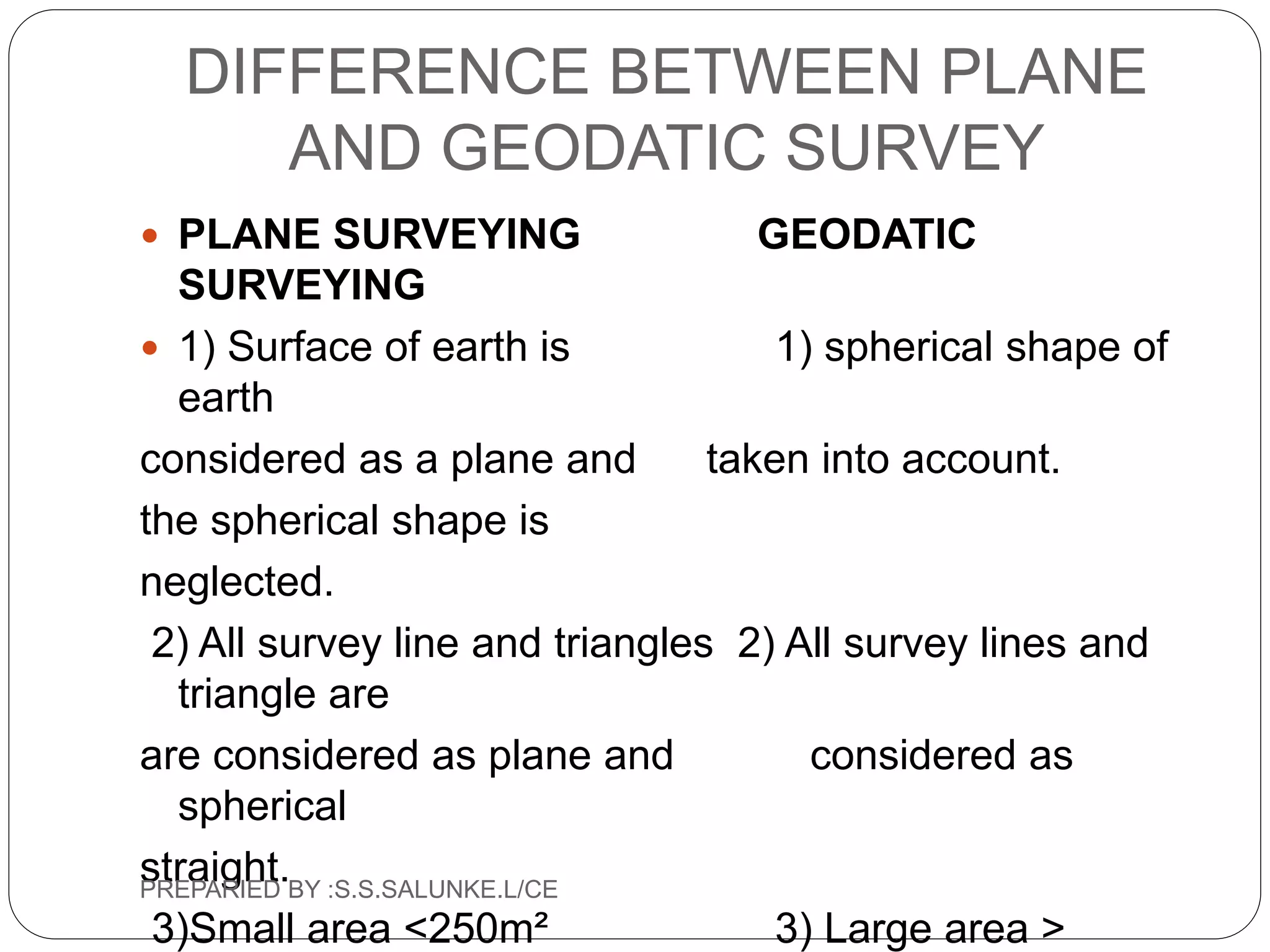
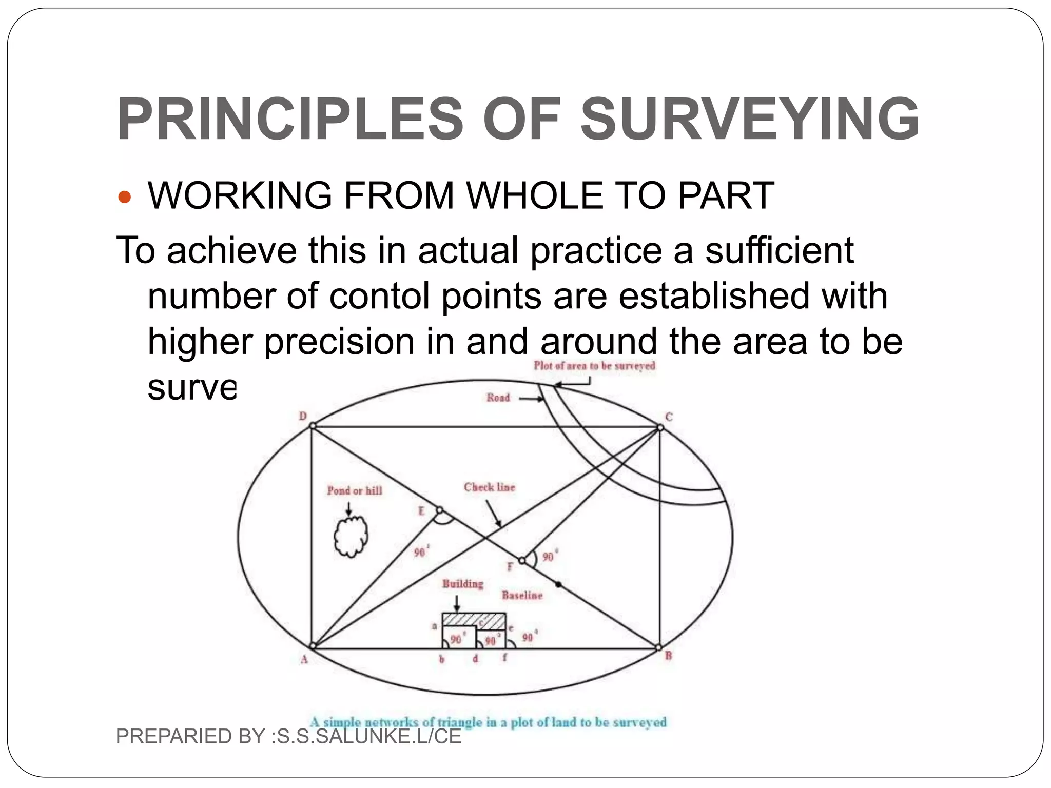
DEPARTMENT OF CIVIL
ENGINEERING
INTRODUCTION TO SURVEYING
PREPARID BY : S.S.SALUNKE.L/CE
B.L.D.E.A s
SHREE
SANGANABASAVAMAHASWAMIJI
POLYTECHNIC
INTRODUCTION TO
SURVEYING
 SURVEYING : It is an art of determining the
absolute and relative position of points, on or
below the earth surface by means of
measurement of distance, direction, elevations.
OBJECTS OF SURVEYING The main primary
object of surveying is to collect precise
information and data for preparation of maps,
plans etc…..
PREPARIED BY :S.S.SALUNKE.L/CE
INTRODUCTION TO
SURVEYING
 PURPOSE OF SURVEYING
1) To locate and measure the property lines.
PREPARIED BY :S.S.SALUNKE.L/CE
INTRODUCTION TO
SURVEYING
 To layout buildings, bridges,channels,highwaiy,
sewers, pipelines for construction
PREPARIED BY :S.S.SALUNKE.L/CE
INTRODUCTION TO
SURVEYING
PREPARIED BY :S.S.SALUNKE.L/CE
PURPOSE OF SURVEYING
 To calculate the distance, areas, and quantities of
various engineering projects
 To establish correctly the boundary points of
property lines etc..
 To fix the national and state boundaries.
 To find out best alignment for canals, roads
railways roadways etc…
 To establish control points
PREPARIED BY :S.S.SALUNKE.L/CE
CLASSIFICATION OF
SURVEYING
CLASSIFICATION BASED ON NATURE OF
FIELD SURVEY.
1. Land survey
2. Hydrographic survey
3. Astronomical survey
PREPARIED BY :S.S.SALUNKE.L/CE
CLASSIFICATION OF
SURVEYING
LAND SURVEYING
Land surveying is carried out to measure
various
objects on land ,its further classified in to,
1. TOPOGRAPHICAL SURVEY
2. CADASTRAL SURVEY
3. CITY SURVEY
PREPARIED BY :S.S.SALUNKE.L/CE
TOPOGRAPHICAL SURVEY
 This survey is used to locate the topography of
mountains, rivers, roads, railways, etc…
PREPARIED BY :S.S.SALUNKE.L/CE
CADASTRAL SURVEY
 This survey is used to fixing the property lines,
calculation of areas, land property and
preparation of revenue maps of state etc…
PREPARIED BY :S.S.SALUNKE.L/CE
CITY SURVEY
 This survey is carried out for construction of
roads, streets, water supply lines, sewer lines
etc…
PREPARIED BY :S.S.SALUNKE.L/CE
CLASSIFICATION BASED ON PURPOSE OF
THE SURVEY.
 ENGINEERING SURVEY
 MILITARY SURVEY
 MINE SURVEY
 GEOLOGICAL SURVEY
 ARCHAEOLOGICAL SURVEY
PREPARIED BY :S.S.SALUNKE.L/CE
ENGINEERING SURVEY
 This survey is carried out to determination of
quantities or collect sufficient data for designing
engineering work,
further its classified in to
• RECONNAISSANCE SURVEY
• PRELIMINARY SURVEY
• LOCTION SURVEY
PREPARIED BY :S.S.SALUNKE.L/CE
ENGINEERING SURVEY
RECONNAISSANCE SURVEY
 This is the first engineering survey carried out to
know the details of proposed project . Information
collected during this survey helful in later stage
during execution of work
PREPARIED BY :S.S.SALUNKE.L/CE
ENGINEERING SURVEY
PRELIMINARY SURVEY
 The object this survey is to conduct the survey
along the alternative routes found out by the
reconnaissance survey and determine with
greater accuracy, hence this survey carried with
great precision.
PREPARIED BY :S.S.SALUNKE.L/CE
ENGINEERING SURVEY
LOCATION SURVEY
 The main object of location survey is to carry out
the detailed survey the route which has been
found and fixed the most economical route from
the data collected in preliminary survey.
PREPARIED BY :S.S.SALUNKE.L/CE
CLASSIFICATION BASED ON
PURPOSE OF THE SURVEY
 MILITARY SURVEY : The survey which are
carried for preparation of maps.
 MINE SURVEY : The survey which are carried for
exploration of minerals form earth like coal, gold,
iron etc
 GEOLOGICAL SURVEY : This survey is used to
study the different types of rocks,soils, etc
 ARCHAEOLOGICAL SURVEY : This survey is
used to find the ancient culture , old monuments
etc
PREPARIED BY :S.S.SALUNKE.L/CE
CLASSIFICATION BASED ON
INSTRUMENT USED
 Chain survey
 Compass survey remote sensing survey
 Plane table survey
 Theodolite survey
 Tachometric survey
 EDM survey
 Remote sensing survey
PREPARIED BY :S.S.SALUNKE.L/CE
PRIMARY DIVISIONS OF
SURVEYING
 The surveying may primarily divided into two
types
1) PLANE SURVEYING
2) GEODETIC SURVEYING
PLANE SURVEYING : In this type of surveying
the earth surface is assumed to be plane and
curvature of the earth is ignored.
GEODATIC SURVEYING : In this type of surveying
the
earth ‘s curvature is taken in to consideration, this
survey is made with high degree of precision.PREPARIED BY :S.S.SALUNKE.L/CE
DIFFERENCE BETWEEN PLANE
AND GEODATIC SURVEY
 PLANE SURVEYING GEODATIC
SURVEYING
 1) Surface of earth is 1) spherical shape of
earth
considered as a plane and taken into account.
the spherical shape is
neglected.
2) All survey line and triangles 2) All survey lines and
triangle are
are considered as plane and considered as
spherical
straight.
3)Small area <250m² 3) Large area >
PREPARIED BY :S.S.SALUNKE.L/CE
PRINCIPLES OF SURVEYING
 The fundamental principles upon which surveying
carried out are
1) Working from Whole to Part
2) To locate a point by at least two measurement.
PREPARIED BY :S.S.SALUNKE.L/CE
PRINCIPLES OF SURVEYING
 WORKING FROM WHOLE TO PART
To achieve this in actual practice a sufficient
number of contol points are established with
higher precision in and around the area to be
surveyed.
PREPARIED BY :S.S.SALUNKE.L/CE
PRINCIPLES OF SURVEYING
 To locate a point by at least two measurement.
object
A B
According to this principle the new station is fixed
by atleast two known fixed reference points
(Linear or Angular)PREPARIED BY :S.S.SALUNKE.L/CE
PREPARIED BY :S.S.SALUNKE.L/CE

Introduction to surveying

  • 1.
    DEPARTMENT OF CIVIL ENGINEERING INTRODUCTIONTO SURVEYING PREPARID BY : S.S.SALUNKE.L/CE B.L.D.E.A s SHREE SANGANABASAVAMAHASWAMIJI POLYTECHNIC
  • 2.
    INTRODUCTION TO SURVEYING  SURVEYING: It is an art of determining the absolute and relative position of points, on or below the earth surface by means of measurement of distance, direction, elevations. OBJECTS OF SURVEYING The main primary object of surveying is to collect precise information and data for preparation of maps, plans etc….. PREPARIED BY :S.S.SALUNKE.L/CE
  • 3.
    INTRODUCTION TO SURVEYING  PURPOSEOF SURVEYING 1) To locate and measure the property lines. PREPARIED BY :S.S.SALUNKE.L/CE
  • 4.
    INTRODUCTION TO SURVEYING  Tolayout buildings, bridges,channels,highwaiy, sewers, pipelines for construction PREPARIED BY :S.S.SALUNKE.L/CE
  • 5.
  • 6.
    PURPOSE OF SURVEYING To calculate the distance, areas, and quantities of various engineering projects  To establish correctly the boundary points of property lines etc..  To fix the national and state boundaries.  To find out best alignment for canals, roads railways roadways etc…  To establish control points PREPARIED BY :S.S.SALUNKE.L/CE
  • 7.
    CLASSIFICATION OF SURVEYING CLASSIFICATION BASEDON NATURE OF FIELD SURVEY. 1. Land survey 2. Hydrographic survey 3. Astronomical survey PREPARIED BY :S.S.SALUNKE.L/CE
  • 8.
    CLASSIFICATION OF SURVEYING LAND SURVEYING Landsurveying is carried out to measure various objects on land ,its further classified in to, 1. TOPOGRAPHICAL SURVEY 2. CADASTRAL SURVEY 3. CITY SURVEY PREPARIED BY :S.S.SALUNKE.L/CE
  • 9.
    TOPOGRAPHICAL SURVEY  Thissurvey is used to locate the topography of mountains, rivers, roads, railways, etc… PREPARIED BY :S.S.SALUNKE.L/CE
  • 10.
    CADASTRAL SURVEY  Thissurvey is used to fixing the property lines, calculation of areas, land property and preparation of revenue maps of state etc… PREPARIED BY :S.S.SALUNKE.L/CE
  • 11.
    CITY SURVEY  Thissurvey is carried out for construction of roads, streets, water supply lines, sewer lines etc… PREPARIED BY :S.S.SALUNKE.L/CE
  • 12.
    CLASSIFICATION BASED ONPURPOSE OF THE SURVEY.  ENGINEERING SURVEY  MILITARY SURVEY  MINE SURVEY  GEOLOGICAL SURVEY  ARCHAEOLOGICAL SURVEY PREPARIED BY :S.S.SALUNKE.L/CE
  • 13.
    ENGINEERING SURVEY  Thissurvey is carried out to determination of quantities or collect sufficient data for designing engineering work, further its classified in to • RECONNAISSANCE SURVEY • PRELIMINARY SURVEY • LOCTION SURVEY PREPARIED BY :S.S.SALUNKE.L/CE
  • 14.
    ENGINEERING SURVEY RECONNAISSANCE SURVEY This is the first engineering survey carried out to know the details of proposed project . Information collected during this survey helful in later stage during execution of work PREPARIED BY :S.S.SALUNKE.L/CE
  • 15.
    ENGINEERING SURVEY PRELIMINARY SURVEY The object this survey is to conduct the survey along the alternative routes found out by the reconnaissance survey and determine with greater accuracy, hence this survey carried with great precision. PREPARIED BY :S.S.SALUNKE.L/CE
  • 16.
    ENGINEERING SURVEY LOCATION SURVEY The main object of location survey is to carry out the detailed survey the route which has been found and fixed the most economical route from the data collected in preliminary survey. PREPARIED BY :S.S.SALUNKE.L/CE
  • 17.
    CLASSIFICATION BASED ON PURPOSEOF THE SURVEY  MILITARY SURVEY : The survey which are carried for preparation of maps.  MINE SURVEY : The survey which are carried for exploration of minerals form earth like coal, gold, iron etc  GEOLOGICAL SURVEY : This survey is used to study the different types of rocks,soils, etc  ARCHAEOLOGICAL SURVEY : This survey is used to find the ancient culture , old monuments etc PREPARIED BY :S.S.SALUNKE.L/CE
  • 18.
    CLASSIFICATION BASED ON INSTRUMENTUSED  Chain survey  Compass survey remote sensing survey  Plane table survey  Theodolite survey  Tachometric survey  EDM survey  Remote sensing survey PREPARIED BY :S.S.SALUNKE.L/CE
  • 19.
    PRIMARY DIVISIONS OF SURVEYING The surveying may primarily divided into two types 1) PLANE SURVEYING 2) GEODETIC SURVEYING PLANE SURVEYING : In this type of surveying the earth surface is assumed to be plane and curvature of the earth is ignored. GEODATIC SURVEYING : In this type of surveying the earth ‘s curvature is taken in to consideration, this survey is made with high degree of precision.PREPARIED BY :S.S.SALUNKE.L/CE
  • 20.
    DIFFERENCE BETWEEN PLANE ANDGEODATIC SURVEY  PLANE SURVEYING GEODATIC SURVEYING  1) Surface of earth is 1) spherical shape of earth considered as a plane and taken into account. the spherical shape is neglected. 2) All survey line and triangles 2) All survey lines and triangle are are considered as plane and considered as spherical straight. 3)Small area <250m² 3) Large area > PREPARIED BY :S.S.SALUNKE.L/CE
  • 21.
    PRINCIPLES OF SURVEYING The fundamental principles upon which surveying carried out are 1) Working from Whole to Part 2) To locate a point by at least two measurement. PREPARIED BY :S.S.SALUNKE.L/CE
  • 22.
    PRINCIPLES OF SURVEYING WORKING FROM WHOLE TO PART To achieve this in actual practice a sufficient number of contol points are established with higher precision in and around the area to be surveyed. PREPARIED BY :S.S.SALUNKE.L/CE
  • 23.
    PRINCIPLES OF SURVEYING To locate a point by at least two measurement. object A B According to this principle the new station is fixed by atleast two known fixed reference points (Linear or Angular)PREPARIED BY :S.S.SALUNKE.L/CE
  • 24.