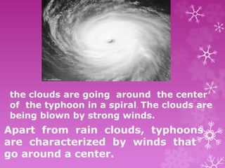
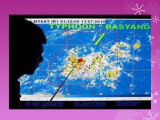
the clouds are going around the center
of the typhoon in a spiral. The clouds are
being blown by strong winds.
Apart from rain clouds, typhoons
are characterized by winds that
go around a center.
If the wind speed is less, from 119
to 200 kph, then it is called a
typhoon. If the wind speed is
between 65 and 118 kph, it is called
a tropical storm. And when the wind
speed is between 35 to 64 kph, it is a
tropical depression.
categories of tropical cyclones
1. Tropical depression
2. tropical storm
3. typhoon,
4. supertyphoon
A tropical cyclone is a system of
thunderstorms that are moving around
a center. As the winds intensify or
weaken, the category is upgraded or
downgraded accordingly.
Table 1. Tropical Cyclone Categories
Category Maximum Wind Speed
kilometers per hour (kph)
Tropical Depression 64
Tropical Storm 118
Typhoon 200
Supertyphoon greater than 200
The term typhoon is used only in the
northwestern part of the Pacific Ocean. In
the northeastern part of the Pacific Ocean
and in the northern part of the Atlantic
Ocean, the equivalent term is hurricane. Thus,
a hurricane on one side of the Pacific Ocean will
be called a typhoon if it crosses into the other
side.
In the Philippines, we use the
same word for all categories of
tropical cyclones. We call it bagyo
whether it is a tropical depression,
a tropical storm or a typhoon.
Activity 1
Plotting the PAR
Objectives:
After performing this activity, you should be
able to:
1. read map,
2. given the latitude and longitude of
a tropical cyclone, tell if it has
entered the Philippine Area of Responsibility,
and
3. explain what is meant when a typhoon
has entered the Philippine Area
of Responsibility.
Materials Needed:
map of the Philippines and vicinity
pencil
Procedure:
1. Plot the following points on the map below
(Figure 2). Points Latitude, Longitude
a. 5°N, 115°E
b. 15°N, 115°E
c. 21°N, 120°E
d. 25°N, 120°E
e. 25°N, 135°E
f. 5°N, 135°E
2. Connect the plotted points. The region
within is the Philippine Area of
Responsibility or PAR. It is the job of PAGASA to
monitor all tropical cyclones that enter this area.
Q1. If a typhoon is located at 15°N, 138°E,
is it within the PAR?
Q2. How about if the typhoon is at 19°N,
117°E, is it inside the PAR?
Answer: No, the typhoon is outside the
PAR.
Answer: No, the typhoon is outside the
PAR.
Under What Conditions do
Tropical Cyclones Form?
Where did the tropical cyclones
form? On land or in the ocean?
It is clear from the maps that all
four tropical cyclones started out in
the Pacific Ocean. Tropical cyclones
usually form where there is warm
water. The temperature should be 26.5°C
or more.
The warm ocean water heats up the air
above it. The warm air then rises. The
rising warm air results in a low-pressure
area. Air in the surroundings will then
move toward the area
Now, there is water vapor in the rising
warm air.The water vapor soon condenses
and heat is given off. The heat makes the
air rise even more,and air in the
surroundings will keep coming in. The
air starts to spin, and a tropical
cyclone is born.
What can you say about the
temperature of the bodies of water
in the vicinity of the Philippines? Is
the water warm or cold?
Our country is located near the equator.
Thus, it is warm in the vicinity of the
Philippines, both on land and in the
surrounding bodies of water. The warm
water supplies the water vapor that a tropical
cyclone needs to keep it going
In what direction did the
tropical cyclones move?
From the map, the students can see
that the tropical cyclones move in a
northwest direction. Not all tropical
cyclones move this way. But this is
the general rule for those that start
There are different reasons why this
happens. One, there could be a low-
pressure area in that region. So the
wind in the surroundings move toward
that region and the tropical cyclone is
carried along. Remember, winds blow
toward low- pressure areas.
Another reason is there could be a high
pressure area in the path of the tropical
cyclone. So the tropical cyclone cannot
proceed and is diverted along a different
way.
Which part of the Philippines was
hit by the four tropical cyclones?
All the four tropical cyclones hit northern
Philippines or the island of Luzon.Note
where the tropical cyclones start: at the
latitude of the Visayas and Mindanao.So
when a tropical cyclone moves to the
northwest, it ends up in Luzon.
This is the reason why Mindanao is
not commonly hit by tropical
cyclones. Unless the following happens: a)
the tropical cyclone starts at a latitude
closer to the equator, or b) the
tropical cyclone moves directly to
the west, instead of moving to the
northwest. This is what happened in
Mindanao in recent years.
In the case of Agaton, Yoyong, and
Huaning, where did they die out?
Near land or in the middle of the ocean?
Tropical cyclones weaken when they hit
land. They die out over land because they
need warm water to sustain them.
They need water vapor to keep them
going. Even when the tropical cyclone is
still in a body of water, it may weaken
and die out if the water is cold.
typhoon.pptx

typhoon.pptx

  • 1.
    the clouds aregoing around the center of the typhoon in a spiral. The clouds are being blown by strong winds. Apart from rain clouds, typhoons are characterized by winds that go around a center.
  • 4.
    If the windspeed is less, from 119 to 200 kph, then it is called a typhoon. If the wind speed is between 65 and 118 kph, it is called a tropical storm. And when the wind speed is between 35 to 64 kph, it is a tropical depression. categories of tropical cyclones 1. Tropical depression 2. tropical storm 3. typhoon, 4. supertyphoon
  • 5.
    A tropical cycloneis a system of thunderstorms that are moving around a center. As the winds intensify or weaken, the category is upgraded or downgraded accordingly. Table 1. Tropical Cyclone Categories Category Maximum Wind Speed kilometers per hour (kph) Tropical Depression 64 Tropical Storm 118 Typhoon 200 Supertyphoon greater than 200
  • 6.
    The term typhoonis used only in the northwestern part of the Pacific Ocean. In the northeastern part of the Pacific Ocean and in the northern part of the Atlantic Ocean, the equivalent term is hurricane. Thus, a hurricane on one side of the Pacific Ocean will be called a typhoon if it crosses into the other side. In the Philippines, we use the same word for all categories of tropical cyclones. We call it bagyo whether it is a tropical depression, a tropical storm or a typhoon.
  • 7.
    Activity 1 Plotting thePAR Objectives: After performing this activity, you should be able to: 1. read map, 2. given the latitude and longitude of a tropical cyclone, tell if it has entered the Philippine Area of Responsibility, and 3. explain what is meant when a typhoon has entered the Philippine Area of Responsibility.
  • 8.
    Materials Needed: map ofthe Philippines and vicinity pencil Procedure: 1. Plot the following points on the map below (Figure 2). Points Latitude, Longitude a. 5°N, 115°E b. 15°N, 115°E c. 21°N, 120°E d. 25°N, 120°E e. 25°N, 135°E f. 5°N, 135°E
  • 9.
    2. Connect theplotted points. The region within is the Philippine Area of Responsibility or PAR. It is the job of PAGASA to monitor all tropical cyclones that enter this area. Q1. If a typhoon is located at 15°N, 138°E, is it within the PAR? Q2. How about if the typhoon is at 19°N, 117°E, is it inside the PAR? Answer: No, the typhoon is outside the PAR. Answer: No, the typhoon is outside the PAR.
  • 11.
    Under What Conditionsdo Tropical Cyclones Form?
  • 13.
    Where did thetropical cyclones form? On land or in the ocean? It is clear from the maps that all four tropical cyclones started out in the Pacific Ocean. Tropical cyclones usually form where there is warm water. The temperature should be 26.5°C or more. The warm ocean water heats up the air above it. The warm air then rises. The rising warm air results in a low-pressure area. Air in the surroundings will then move toward the area
  • 14.
    Now, there iswater vapor in the rising warm air.The water vapor soon condenses and heat is given off. The heat makes the air rise even more,and air in the surroundings will keep coming in. The air starts to spin, and a tropical cyclone is born. What can you say about the temperature of the bodies of water in the vicinity of the Philippines? Is the water warm or cold?
  • 15.
    Our country islocated near the equator. Thus, it is warm in the vicinity of the Philippines, both on land and in the surrounding bodies of water. The warm water supplies the water vapor that a tropical cyclone needs to keep it going In what direction did the tropical cyclones move? From the map, the students can see that the tropical cyclones move in a northwest direction. Not all tropical cyclones move this way. But this is the general rule for those that start
  • 16.
    There are differentreasons why this happens. One, there could be a low- pressure area in that region. So the wind in the surroundings move toward that region and the tropical cyclone is carried along. Remember, winds blow toward low- pressure areas. Another reason is there could be a high pressure area in the path of the tropical cyclone. So the tropical cyclone cannot proceed and is diverted along a different way.
  • 17.
    Which part ofthe Philippines was hit by the four tropical cyclones? All the four tropical cyclones hit northern Philippines or the island of Luzon.Note where the tropical cyclones start: at the latitude of the Visayas and Mindanao.So when a tropical cyclone moves to the northwest, it ends up in Luzon.
  • 18.
    This is thereason why Mindanao is not commonly hit by tropical cyclones. Unless the following happens: a) the tropical cyclone starts at a latitude closer to the equator, or b) the tropical cyclone moves directly to the west, instead of moving to the northwest. This is what happened in Mindanao in recent years.
  • 19.
    In the caseof Agaton, Yoyong, and Huaning, where did they die out? Near land or in the middle of the ocean? Tropical cyclones weaken when they hit land. They die out over land because they need warm water to sustain them. They need water vapor to keep them going. Even when the tropical cyclone is still in a body of water, it may weaken and die out if the water is cold.