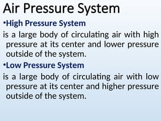
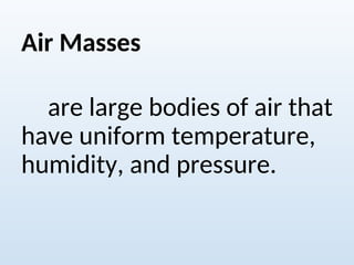
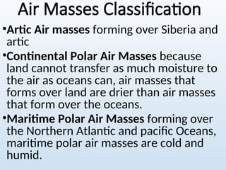
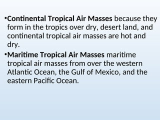
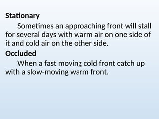
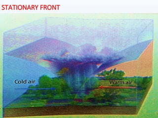
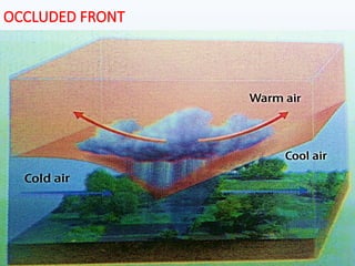
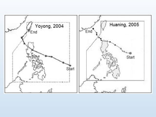
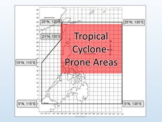
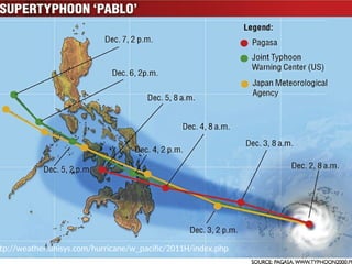
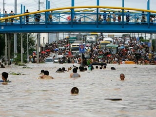
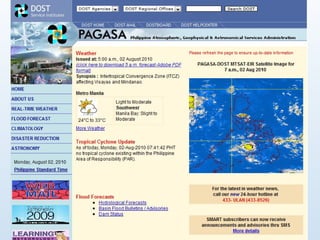
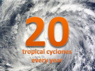
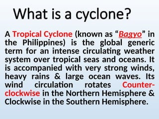
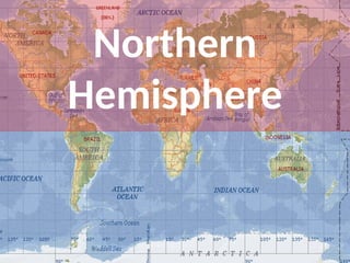
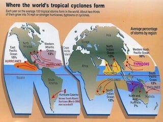
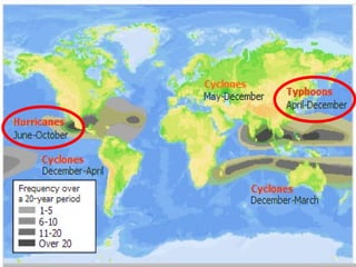
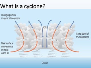
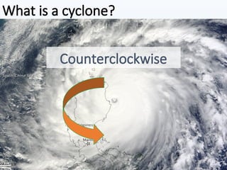
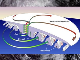
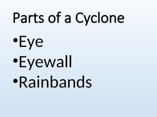
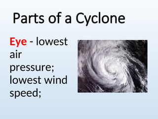
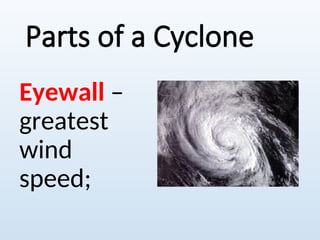
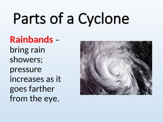
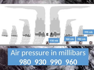
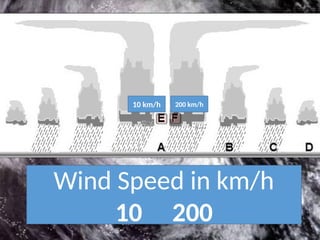
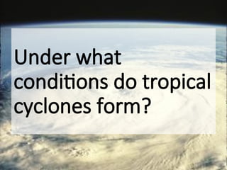
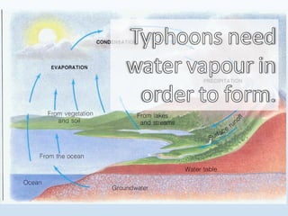
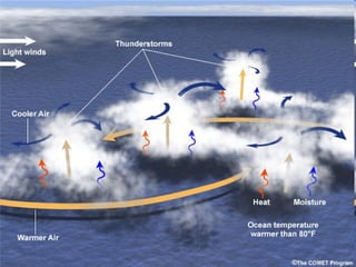
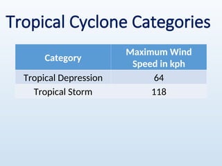
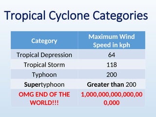
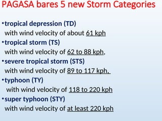
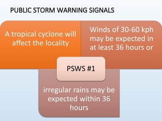
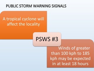
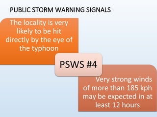
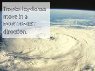
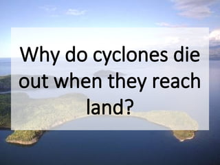
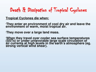
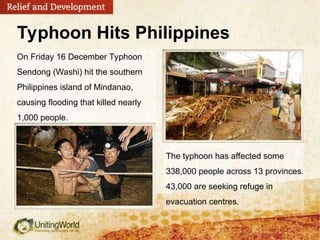
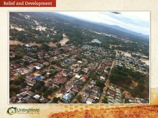
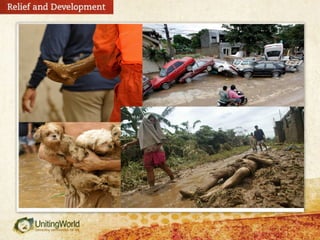
Typhoons
Air Pressure System
•High Pressure System
is a large body of circulating air with high
pressure at its center and lower pressure
outside of the system.
•Low Pressure System
is a large body of circulating air with low
pressure at its center and higher pressure
outside of the system.
Air Masses
are large bodies of air that
have uniform temperature,
humidity, and pressure.
Air Masses Classification
•Artic Air masses forming over Siberia and
artic
•Continental Polar Air Masses because
land cannot transfer as much moisture to
the air as oceans can, air masses that
forms over land are drier than air masses
that form over the oceans.
•Maritime Polar Air Masses forming over
the Northern Atlantic and pacific Oceans,
maritime polar air masses are cold and
humid.
•Continental Tropical Air Masses because they
form in the tropics over dry, desert land, and
continental tropical air masses are hot and
dry.
•Maritime Tropical Air Masses maritime
tropical air masses from over the western
Atlantic Ocean, the Gulf of Mexico, and the
eastern Pacific Ocean.
Air Masses
Fronts
is a boundary between two air masses.
Cold Fronts
When a colder air masses moves toward a
warmer air mass, a cold fronts forms. The cold
air, which is denser than the warm air, pushes
underneath the warm air masses.
Warm Fronts
A warm fronts form when less dense,
warmer air moves toward colder, denser air.
The warm air rises as it glides above the cold air
masses.
COLD FRONT
WARM
FRONT
Stationary
Sometimes an approaching front will stall
for several days with warm air on one side of
it and cold air on the other side.
Occluded
When a fast moving cold front catch up
with a slow-moving warm front.
STATIONARY FRONT
OCCLUDED FRONT
The PAR
Near, PAR,
wherever you
are. 
Philippine
Area of
Responsibility
Where
is the
PAR?
jpmartizano
Plotting the PAR
jpmartizano
Points Latitude Longitude
a 5°N 115°E
b 15°N 115°E
c 21°N 120°E
d 25°N 120°E
e 25°N 135°E
f 5°N 135°E
jpmartizano
jpmartizano
jpmartizano
jpmartizano
jpmartizano
ttp://weather.unisys.com/hurricane/w_pacific/2011H/index.php
Understanding
Typhoons
Rain, rain go away….NOT!
What is a cyclone?
A Tropical Cyclone (known as “Bagyo” in
the Philippines) is the global generic
term for an intense circulating weather
system over tropical seas and oceans. It
is accompanied with very strong winds,
heavy rains & large ocean waves. Its
wind circulation rotates Counter-
clockwise in the Northern Hemisphere &
Clockwise in the Southern Hemisphere.
Northern
Hemisphere
What is a cyclone?
What is a cyclone?
Counterclockwise
Let’s dissect
the cyclone!
Parts of a Cyclone
•Eye
•Eyewall
•Rainbands
Parts of a Cyclone
Eye - lowest
air
pressure;
lowest wind
speed;
Parts of a Cyclone
Eyewall –
greatest
wind
speed;
Parts of a Cyclone
Rainbands –
bring rain
showers;
pressure
increases as it
goes farther
from the eye.
Air pressure in millibars
980 930 990 960
930 mb
960 mb 980 mb
990 mb
Wind Speed in km/h
10 200
10 km/h 200 km/h
Storm Surge
Under what
conditions do tropical
cyclones form?
There are a couple of Ingredients that will
benefit for the formation of a Tropical
Cyclone here in the Philippine Sea and
Western Pacific Ocean. These are:

Warm Sea Surface Temperature (SST) of at
least 26.5°C with a depth of 150 feet & high
moisture/ humidity present in the
atmosphere. The heat from the sea is
therefore the main energy source for Tropical
Cyclones.

Presence of the Intertropical
Convergence Zone (ITCZ). The ITCZ plays
an important role in the formation of
Tropical Cyclones as it delivers
convergence of Northeasterly &
Southeasterly or Southwesterly Trade
winds. Its convergence will trigger a
rotation of low-level winds which then
develop into Tropical Cyclones - if other
ingredients are present .
•Existence of Tropical Disturbances (aka.
Low Pressure Areas or LPAs) within the
ITCZ. When the ITCZ is very active,
multiple tropical disturbances occur and
it aids for development of Tropical
Cyclones.
•Weak vertical wind shear or light winds
in the upper atmosphere. If wind speeds
in the upper atmosphere (20-50,000 feet
ASL) are low (<20 km/hr), a TC can
develop rapidly usually within 1 to 2
days.
Tropical Cyclone Categories
Category
Maximum Wind
Speed in kph
Tropical Depression 64
Tropical Storm 118
Category
Maximum Wind
Speed in kph
Tropical Depression 64
Tropical Storm 118
Typhoon 200
Supertyphoon Greater than 200
OMG END OF THE
WORLD!!!
1,000,000,000,000,00
0,000
Tropical Cyclone Categories
PAGASA bares 5 new Storm Categories
•tropical depression (TD)
with wind velocity of about 61 kph
•tropical storm (TS)
with wind velocity of 62 to 88 kph,
•severe tropical storm (STS)
with wind velocity of 89 to 117 kph,
•typhoon (TY)
with wind velocity of 118 to 220 kph
•super typhoon (STY)
with wind velocity of at least 220 kph
Are You Prepared?
http://gawker.com/5834445/how-to-prepare-for-a-hurri
cane
The typhoon has affected some
338,000 people across 13 provinces.
43,000 are seeking refuge in
evacuation centres.
On Friday 16 December Typhoon
Sendong (Washi) hit the southern
Philippines island of Mindanao,
causing flooding that killed nearly
1,000 people.
Typhoon Hits Philippines
PUBLIC STORM WARNING SIGNALS
jpmartizano
jpmartizano
jpmartizano
ttp://weather.unisys.com/hurricane/w_pacific/2011H/index.php
Why do cyclones die
out when they reach
land?
Death & Dissipation of Tropical Cyclones
Tropical Cyclones die when:

They enter an environment of cool dry air and leave the
environment of warm, moist tropical air.

They move over a large land mass.

When they travel over cooler sea surface temperatures
(SSTs) or under unfavorable large scale circulation of
air currents at high levels in the earth’s atmosphere (eg.
strong vertical wind shear).
The typhoon has affected some
338,000 people across 13 provinces.
43,000 are seeking refuge in
evacuation centres.
On Friday 16 December Typhoon
Sendong (Washi) hit the southern
Philippines island of Mindanao,
causing flooding that killed nearly
1,000 people.
Typhoon Hits Philippines
EMERGENCY KIT
EMERGENCY KIT
EMERGENCY KIT
Useful Websites
For added info, YAY!
jpmartizano
jpmartizano
nasa.gov
jpmartizano
noaa.gov
jpmartizano
nhc.noaa.gov
weather forcast-typhoonweather forcast-typhoon.ppt

weather forcast-typhoonweather forcast-typhoon.ppt

  • 1.
  • 2.
    Air Pressure System •HighPressure System is a large body of circulating air with high pressure at its center and lower pressure outside of the system. •Low Pressure System is a large body of circulating air with low pressure at its center and higher pressure outside of the system.
  • 3.
    Air Masses are largebodies of air that have uniform temperature, humidity, and pressure.
  • 4.
    Air Masses Classification •ArticAir masses forming over Siberia and artic •Continental Polar Air Masses because land cannot transfer as much moisture to the air as oceans can, air masses that forms over land are drier than air masses that form over the oceans. •Maritime Polar Air Masses forming over the Northern Atlantic and pacific Oceans, maritime polar air masses are cold and humid.
  • 5.
    •Continental Tropical AirMasses because they form in the tropics over dry, desert land, and continental tropical air masses are hot and dry. •Maritime Tropical Air Masses maritime tropical air masses from over the western Atlantic Ocean, the Gulf of Mexico, and the eastern Pacific Ocean.
  • 6.
  • 7.
    Fronts is a boundarybetween two air masses. Cold Fronts When a colder air masses moves toward a warmer air mass, a cold fronts forms. The cold air, which is denser than the warm air, pushes underneath the warm air masses. Warm Fronts A warm fronts form when less dense, warmer air moves toward colder, denser air. The warm air rises as it glides above the cold air masses.
  • 8.
  • 9.
  • 10.
    Stationary Sometimes an approachingfront will stall for several days with warm air on one side of it and cold air on the other side. Occluded When a fast moving cold front catch up with a slow-moving warm front.
  • 11.
  • 12.
  • 13.
  • 14.
  • 15.
  • 16.
    Plotting the PAR jpmartizano PointsLatitude Longitude a 5°N 115°E b 15°N 115°E c 21°N 120°E d 25°N 120°E e 25°N 135°E f 5°N 135°E
  • 17.
  • 18.
  • 23.
  • 24.
  • 25.
  • 26.
  • 30.
    What is acyclone? A Tropical Cyclone (known as “Bagyo” in the Philippines) is the global generic term for an intense circulating weather system over tropical seas and oceans. It is accompanied with very strong winds, heavy rains & large ocean waves. Its wind circulation rotates Counter- clockwise in the Northern Hemisphere & Clockwise in the Southern Hemisphere.
  • 31.
  • 34.
    What is acyclone?
  • 35.
    What is acyclone? Counterclockwise
  • 37.
  • 39.
    Parts of aCyclone •Eye •Eyewall •Rainbands
  • 40.
    Parts of aCyclone Eye - lowest air pressure; lowest wind speed;
  • 41.
    Parts of aCyclone Eyewall – greatest wind speed;
  • 42.
    Parts of aCyclone Rainbands – bring rain showers; pressure increases as it goes farther from the eye.
  • 43.
    Air pressure inmillibars 980 930 990 960 930 mb 960 mb 980 mb 990 mb
  • 44.
    Wind Speed inkm/h 10 200 10 km/h 200 km/h
  • 45.
  • 46.
    Under what conditions dotropical cyclones form?
  • 47.
    There are acouple of Ingredients that will benefit for the formation of a Tropical Cyclone here in the Philippine Sea and Western Pacific Ocean. These are:  Warm Sea Surface Temperature (SST) of at least 26.5°C with a depth of 150 feet & high moisture/ humidity present in the atmosphere. The heat from the sea is therefore the main energy source for Tropical Cyclones.
  • 49.
     Presence of theIntertropical Convergence Zone (ITCZ). The ITCZ plays an important role in the formation of Tropical Cyclones as it delivers convergence of Northeasterly & Southeasterly or Southwesterly Trade winds. Its convergence will trigger a rotation of low-level winds which then develop into Tropical Cyclones - if other ingredients are present .
  • 50.
    •Existence of TropicalDisturbances (aka. Low Pressure Areas or LPAs) within the ITCZ. When the ITCZ is very active, multiple tropical disturbances occur and it aids for development of Tropical Cyclones. •Weak vertical wind shear or light winds in the upper atmosphere. If wind speeds in the upper atmosphere (20-50,000 feet ASL) are low (<20 km/hr), a TC can develop rapidly usually within 1 to 2 days.
  • 53.
    Tropical Cyclone Categories Category MaximumWind Speed in kph Tropical Depression 64 Tropical Storm 118
  • 54.
    Category Maximum Wind Speed inkph Tropical Depression 64 Tropical Storm 118 Typhoon 200 Supertyphoon Greater than 200 OMG END OF THE WORLD!!! 1,000,000,000,000,00 0,000 Tropical Cyclone Categories
  • 55.
    PAGASA bares 5new Storm Categories •tropical depression (TD) with wind velocity of about 61 kph •tropical storm (TS) with wind velocity of 62 to 88 kph, •severe tropical storm (STS) with wind velocity of 89 to 117 kph, •typhoon (TY) with wind velocity of 118 to 220 kph •super typhoon (STY) with wind velocity of at least 220 kph
  • 56.
  • 57.
    The typhoon hasaffected some 338,000 people across 13 provinces. 43,000 are seeking refuge in evacuation centres. On Friday 16 December Typhoon Sendong (Washi) hit the southern Philippines island of Mindanao, causing flooding that killed nearly 1,000 people. Typhoon Hits Philippines
  • 60.
  • 61.
  • 62.
  • 63.
  • 65.
  • 66.
  • 67.
  • 68.
    Why do cyclonesdie out when they reach land?
  • 69.
    Death & Dissipationof Tropical Cyclones Tropical Cyclones die when:  They enter an environment of cool dry air and leave the environment of warm, moist tropical air.  They move over a large land mass.  When they travel over cooler sea surface temperatures (SSTs) or under unfavorable large scale circulation of air currents at high levels in the earth’s atmosphere (eg. strong vertical wind shear).
  • 70.
    The typhoon hasaffected some 338,000 people across 13 provinces. 43,000 are seeking refuge in evacuation centres. On Friday 16 December Typhoon Sendong (Washi) hit the southern Philippines island of Mindanao, causing flooding that killed nearly 1,000 people. Typhoon Hits Philippines
  • 74.
  • 75.
  • 76.
  • 78.
  • 79.
  • 80.
  • 81.
  • 82.

Editor's Notes

  • #38 Hurakan = god of storms
  • #42 The reason is because there are large-scale winds that push the tropical cyclones in that direction. This is similar to the way a whirlpool is carried along by a flowing stream.
  • #43 One thing about tropical cyclones that we should watch out for are the strong winds. Let us now take a peek inside a tropical cyclone and find out in which part would we experience strong winds.
  • #54 Thus, tropical cyclones require warm ocean waters to be able to develop. According to scientists, the temperature of ocean water must be 26.5°C or greater. Given this information, do you think typhoons can form in latitudes away from the equator? Why or why not?
  • #57 Which is a better source of water vapor, landmasses or oceans? The answer is obvious. But not all parts of the ocean can provide water vapor. Where do you think would evaporation be greatest, near the equator or away from the equator?
  • #59 Chinese Taai fung = big wind
  • #60 Chinese Taai fung = big wind
  • #63 Sendong started out in the Pacific as an area of low pressure. Because it was just a low-pressure area, it was not given a name. Then it intensified into a tropical depression. Again it was not yet given a name because it was still outside the PAR.
  • #81 The reason is because there are large-scale winds that push the tropical cyclones in that direction. This is similar to the way a whirlpool is carried along by a flowing stream.
  • #88 Sendong started out in the Pacific as an area of low pressure. Because it was just a low-pressure area, it was not given a name. Then it intensified into a tropical depression. Again it was not yet given a name because it was still outside the PAR.