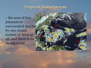
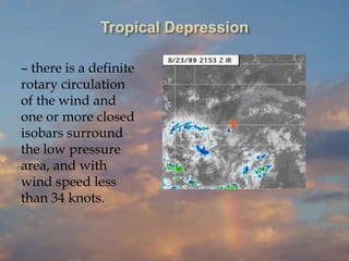
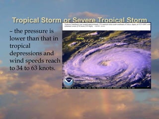
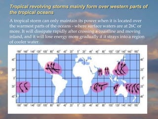
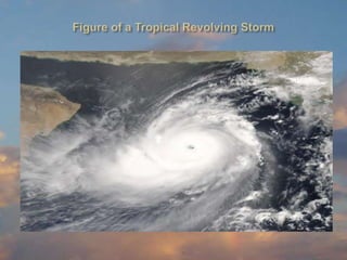
TROPICAL REVOLVING STORM
These are known as revolving, because the wind in
the affected area goes around (rotary circulation) a
centre that has the lowest pressure. In the northern
hemisphere, the wind circulation is counter clockwise
and in the southern hemisphere it is clockwise. In the
middle latitudes, both north and south, these storms
usually develop along fronts and begin as a depression.
In these latitudes they are known as Extra-Tropical
Cyclones. Extra-tropical cyclone is also called a wave
cyclone or wave depression because it deforms the
fronts into a wave. The ones that form in the tropics are
the most dangerous and are called Tropical Revolving
Storms or Tropical Cyclones.
 North Atlantic – South of Lat. 35° from north of
Caribbean to the gulf of Mexico; occurs mostly from
June to November but also occur any month; known
as Hurricane.
 Eastern North Pacific – occurs mostly from June
through October, but can occur any month; known
as Hurricane.
 Western North Pacific – most of tropical revolving
storms form in this region from April through
December, although it may occur in January to
March. The majority of this storms form east of
the Philippines and move to the South China
Sea or up to Japan after recurving; known as
Typhoon. They are the largest and strongest.
 North Indian Ocean, Bay of Bengal and Arabian sea
- occurs from February through October; known as
Cyclone.
 South Indian Ocean - West of longitude 100° E and
South of latitude 10° S occurs mostly from December
through March; known as Cyclone.
 South Pacific and Australian Area – from longitude
105° E to 160° W between latitudes 50° S and 20° S
occurs from December through April; known as
Hurricane in South Pacific and Willy-Willy in the
Australian Area.
Note: Tropical revolving storm do not occur when
between latitudes 5° N and 5° S due to very little
effect on the Coriolis force and its absence at the
equator.
In the stages of development of a tropical
revolving storm, the World Meteorological
Organization (WMO) has laid down the
following nomenclature according to its
intensity.
Tropical Disturbances
– the area of low
pressure is
surrounded maybe
by one closed
isobars or none at
all, and there is no
strong wind.
Tropical Depression
– there is a definite
rotary circulation
of the wind and
one or more closed
isobars surround
the low pressure
area, and with
wind speed less
than 34 knots.
Tropical Storm or Severe Tropical Storm
– the pressure is
lower than that in
tropical
depressions and
wind speeds reach
to 34 to 63 knots.
In regard to the causes of formation of tropical
revolving storms the present studies are still
incomplete. However, after observing and
studying these storms for many years, theories
have been formed and most meteorologists have
agreed that the following conditions are
favourable in their development:
a. Where and when large sea surface temperature
is highest, usually in the western parts of the
oceans in the tropics during summer, 26°C or
higher.
b. The location should be at latitude more than 5°N
or S.
Hurricane/Typhoon/Cyclone
– the pressure at
the centre is much
lower and
sustained winds
are 64 knots or
over. Typhoons in
general cover a
large area than
hurricanes.
Tropical Revolving Storms Extra Tropical Cyclones
Have no accompanying fronts. Accompanied by fronts.
Have a warm centre compared to
temperature on the periphery of
the storm.
Have a cold centre compared to
temperature on periphery of the
storm.
Have the stronger winds when
fully developed.
Have less strong winds.
Average diameter of storm field is
about 400-500 miles. Have an “eye”
(centre) that is almost windless and
cloudless.
Average diameter of storm about
1,200-1,500 miles. Have no “eye”.
Move in westerly direction from
the place of formation.
May move in any direction seldom
towards the west.
c. Small variation of wind direction with
height. This means that the area should be
away from the subtropical jet stream.
d. Previously existing tropical depression. This
is found to be an essential condition.
Tropical revolving storms travel from place
of origin in westward direction and inclined
more and more towards the pole and then
curve eastward approximately between
latitudes 25° and 30° N or S. The position
where its westward movement changes to
eastward is called the “point of recurvature”.
Thus, in the northern hemisphere the general
direction of movement is roughly west,
northwest, north and finally northeast. In the
southern hemisphere it is west, southwest,
south and finally southeast.
After reaching temperate latitudes, the
storms tend to dissipate (disperse) or join
up with extra-tropical cyclones and lose
its character as a tropical storm. The
easterly wave gives the storm its initial
westerly movement. However, some
storms do not follow this pattern and
move erratically.
¤ Storm field – this is the region covered for time
being by the winds forming the storm.
¤ Track – this is the route along which the vortex
(centre) has travelled.
¤ Path – this is the route along which the centre
is expected to travel.
¤ Vortex or Centre or Eye – this is the central
almost windless area within the ring of
hurricane force wind, and where the
atmospheric pressure (barometric pressure)
is lowest. The sky above is usually clear but
the sea is confused and mountainous.
¤ Right-hand semi circle – the right side half of
the storm field for an observer looking towards
the path. In the northern hemisphere, this is the
dangerous semicircle and the forward
quadrant is called the “dangerous quadrant.”
¤ Left-hand Semicircle – the left side half of the
storm field for an observer looking toward the
path. In the northern hemisphere this is the
“navigable semicircle.”
Note: In the southern hemisphere, the
right-hand semicircle is the navigable
semicircle, and the left-hand semicircle is the
dangerous semicircle.
¤ Trough line – a line through the centre of the
storm at right angles to the path. The
dividing line between falling (decreasing)
and rising pressure.
¤ Bar of the storm – the advancing edge of the
storm field.
¤ Vertex or cod – the farthest westerly point on
the storm track.
¤ Angle of Indraft – this is the angle that the
wind direction makes with isobars.
Note: In the dangerous semicircle the
winds are stronger than in the navigable
semicircle, and the rotary direction is
more inclined towards the centre. A
ship caught in this area is bound to be
driven into the centre of the storm if not
correctly manoeuvred.
In the NH, storm winds circulate counterclockwise around the
center of a Low. Thus, when facing in the same direction the
storm is moving, the left side has wind blowing aft, the right
side has wind blowing forward. If the storm were stationary,
the wind speed on either side would be about the same if we
sailed into it. When it starts to move, however, this is no
longer the case.
Another independent factor contributes to the strength of the
wind on the right side. Tropical storms tend to move westward
through the northern Tropics, which leaves the subtropical Highs
on their right hand side. As the storms approach the isobar
pattern around the Highs, their own isobars are compressed
giving rise to stronger winds on the side closest to the High. This
type of isobar compression is exactly what takes place in the case
of a "lee trough" packed up against a stationary High.
When a storm approaches so as to leave you on its dangerous
side, its increasing winds tend to push you into the path of the
storm (north or south of the equator), whereas on the navigable
side the building wind pushes you away from the path of a storm.
Recall that just some 80 to 100 miles from a typical hurricane
center, storm winds could be down to 40 knots or so. Sailing
against the wind in big seas on the dangerous side can mean no
progress at all, versus accelerated progress away from it on the
navigable side.
Tropical revolving storms mainly form over western parts of
the tropical oceans
A tropical storm can only maintain its power when it is located over
the warmest parts of the oceans - where surface waters are at 26C or
more. It will dissipate rapidly after crossing a coastline and moving
inland, and it will lose energy more gradually if it strays into a region
of cooler water.
Since, it is great importance to know that
there is a storm in the area where you are
navigating, you should be aware of its early
signs in order to be prepared of what course of
action to take. A storm may still be some 1,000
miles away but its existence could already be
known by lower barometric reading than
normal, appearance of certain clouds and the
state of the sea. The following is the sequence
of change of the weather as a storm approaches
the position of an observer.
1. A corrected barometric reading of 3 mb or lower
than the mean pressure on that area for the time of
the year as shown in the Admiralty Pilots or other
sources. If the reading is 5 mb or lower than
normal, it is certain that a depression is in your
vicinity about 200 miles away.
2. Presence of exceptionally long swells at the rate of
about 2 – 3 crest per minute. In deep open water,
these swells come from the general direction of the
storm’s centre.
3. Appearance of cirrus cloud in bands that converge
at a point above the horizon. The point of
convergence when next seen remains in the same
direction the storm centre will pass over or near
the observer’s place.
4. Thin layer of cirrostratus cloud covering the whole
sky that causes a halo around the sun or moon. At
this stage, a marked change in wind direction is
observed.
5. Other types of clouds cover the sky, more of thick
layers of altostratus and there is a red tint at
sunrise; increasing wind force is noted.
6. As the barometer continuous to fall squally weather
begins, scud (Cu fractus and St fractus) are now
seen below the thick covering of clouds. At this
stage, the sea is now very rough.
7. The “bar” of the storms appear on the horizon,
darkest part of which is the direction of the
storm centre. The wind force is now 12, rain
continuously falling in torrents, sea is high,
dense and low clouds darken the sky,
barometer rapidly falling.
(At this stage, where your ship should not be
there in the first place, you should manoeuvre
your ship correctly in order not to be overrun
by the vortex ; otherwise you may start
praying the HAIL MARY).
The fury of a typhoon or hurricane or cyclone cannot
exactly be described in words. It has to be experienced
in order that is awesomeness could be appreciated.
Seafarers caught in a killer storm weather, they know it,
or not are just one step to a watery grave. The author
was a junior officer on board an ocean-going vessel that
was caught in a storm field of typhoon Ida on
September 1958, possibly the strongest Pacific typhoon
recorded. The following is a reproduction of an extract
from the ship’s Deck Logbook. Extracts from the
logbook of the Panamanian S.S. “Venus” of 9800 GRT
burden: “Sept. 15, 1958, 1400 hrs.” typhoon “IDA”
recurving, from D.R. Position L 25°- 49’N Lo 140°-23’E
distance 100 miles, manoeuvrings to evade path of
storm.
In the direction of storm centre over the sea very
dark heavy Cb clouds, rain heavy and continuous,
squall lines coming one after another, wind SSW
force 12, loud shrieking sounds heard on riggings
and superstructures, very high seas with top of
waves breaking and blown by wind mixing with
rain, airfoil of water, cannot see anything beyond
H.#3 and #4. Sea and sky appear joined together as
one, barometer steady at 898 mb. Topmast of main
mast broke and fell on deck portside, very hard to
steer ship, main deck awash, shipping very heavy
seas up to boat deck, portside lifeboats wash over
board and on starboard. Damage......”
If the eye of the storm passes over the observer’s position
, the winds suddenly weaken to just a breeze as the eye
passes, the rain stops and the sky clears that sunlight can be
seen in the day, but confused and mountainous wave come
from all sides, and the barometer reaches its lowest reading.
When the eye has passed the wind resumes with full
violence as suddenly as it stopped but from the opposite
direction.
Typical cloud formations associated with tropical
revolving storms are cirrus, cirrostratus, altostratus,
stratocumulus, and cumulonimbus and scuds.
Clouds
that indicates
an approaching
bad weather
CLOUDS
Cirrus ( Ci) –
detached clouds of
delicate and fibrous
appearance, without
shading, generally
white in colour,
often of a silky
appearance. Tufted
cirrus clouds are
popularly known as
“Mares Tails”.
CLOUDS
Cirrostratus (Cs) – a
thin, whitish veil,
which does not blur
the outlines of the
sun or moon, but
gives rise to halos.
CLOUDS
Altostratus ( As) –
striated or fibrous
veil, more or less
grey or bluish in
colour.
CLOUDS
Stratocumulus (Sc)
– a layer, or patches,
composed of
globular masses or
loss; the smallest of
the regularly
arranged elements
are fairly large; they
are soft and grey
with darker parts.
CLOUDS
Cumulonimbus
(Cb) – heavy masses
of cloud with great
general vertical
development,
whose cumuliform
summits rise in the
form of mountains
or towers, the upper
parts having a
fibrous texture and
often spreading out
in the shape of an
anvil.
CLOUDS
Scuds - are formed
as the cooler (and
often more moist)
downdraft of a
thunderstorm lifts
the relatively warm
air near the surf
These clouds
condense as the
warm, moist air
saturates through
ascent and is
pushed outward
from the storm.
‘Beaufort Notation’
- a system of notation devised by Admiral
Beaufort, consisting as a rule of the initial letter
of the phenomenon to be indicated, has been in
use for many years. It affords a simple and
concise means of indicating by a group of
letters either the actual state of the weather at
the hour of observation (present weather); or a
general summary of the conditions over the
interval since the last observation was made,
(past weather). (Brown’s Nautical Almanac
2002)
Beaufort
Letters
Weather
Beaufort
Letters
Weather
b Blue sky (0-1)
clouded
fs Fog over Sea
(Coast Station)
bc Sky partly (1-3)
clouded
fg Fog over low
ground (Inland
Station)
c Cloudy (more
than 3 clouded)
g Gale ( Beaufort
force 8-9
maintained for
period of not less
than 10 minutes).
Beaufort
Letters
Weather
Beaufort
Letters
Weather
d Dizzle G Storm ( Beaufort
force 8-9
maintained for
period of not less
than 10 minutes).
e Wet Air (without
precipitation)
h Hail
f Fog jp Precipitation in
sight of station
Beaufort
Letters
Weather
Beaufort
Letters
Weather
kq Line Squall p Passing showers
ks Storm of drifting
Snow
q Squall weather
kz Sandstorm or
dust storm
r Rain
Beaufort
Letters
Weather
Beaufort
Letters
Weather
l Lightning rs Sleet
m Mist s Snow
o Overcast sky (i.e.
Completely
covered with a
uniform layer of
thick or heavy
cloud).
t/r or t/s Thunderstorm
with rain or snow
Beaufort
Letters
Weather
Beaufort
Letters
Weather
u Ugly, threatening
sky
x Hoar Frost
v Unusual visibility y Dry air
w Dew z Haze
The main source of energy that
powers tropical storm is the latent heat
that is released during condensation of
the water vapor in the ascending
currents of tropical air mass.
To avoid the full fury of a tropical storm early
determination of its location and direction of travel
relative to the vessel’s position is essential. The
Maritime Weather Broadcast (weather report
broadcast by shore stations) provides information
about the storm’s location, direction and speed of
movement, wind force, state at sea, etc. Printouts
from the facsimile machine also give these
informations. Although these are reliable sources
the information obtained should, however, be
rechecked by actual observation of the weather
made on board the ship in order to enable the
vessel to be manoeuvred to the best advantage.
When the centre is within radar range, it might be
located by radar.
IDW28201
Australian Government Bureau of Meteorology
Western Australia
TOP PRIORITY FOR IMMEDIATE BROADCAST SEVERE
THUNDERSTORM WARNING
for Damaging Winds, Large Hail and Flash Flooding For people in the
Southeast Coastal District, Goldfields and adjacent parts of the Central
Wheat Belt, Great Southern and South Coastal Districts.
Issued at 4:00 pm on Wednesday 10 February 2010 People are advised
that there is a risk of severe thunderstorms during this afternoon and
evening. Storms may be accompanied by very heavy rainfall conducive to
flash flooding, large hail and strong winds that could result in damage to
property. FESA State Emergency Service advises people to secure loose
items, move vehicles under cover and stay inside away from windows. If
there is lightning unplug electrical appliances and avoid using landline
telephones. If caught outside find shelter away from trees, powerlines,
storm water drains and streams. If driving through heavy rain slow down
and turn your lights on or if visibility becomes low pull over and park
until it passes. For SES assistance call 132 500. For more safety tips visit
www.fesa.wa.gov.au The next warning will be issued by 7:00 pm
Wednesday This warning is also available through TV and Radio
broadcasts; the Bureau's website at www.bom.gov.au or call 1300 659 213.
To locate the storm centre by actual
observation employ the Buys Ballot’s Law,
that is in the northern hemisphere face the
wind and the centre is 10 to 12 point of the
compass to your right when it is about 200
miles away and 8 points to your right when
already near your position. In the southern
hemisphere, it is to your left when you face the
wind and the same points of the compass
above.
NORTHERN HEMISPHERE
SOUTHERN HEMISPHERE
L
First determined the true wind direction. If the wind is
veering (shifting to the right) the vessel is in in the right-
hand semicircle; if the wind is backing (shifting to the left)
the vessel is in left-hand semicircle.
This rule is true in both hemisphere so that by means of this
you will know whether your vessel is in the dangerous
semicircle or in the navigable semicircle. If the winds
remains steady in direction and barometer is falling the
vessel is in the direct path of the storm, or is going at the
same speed and direction as the storm.
If you are not sure of the storm’s movement relative to the
vessel, you should heave-to (stop the ship) until this is
ascertained. The storm’s movement must be continuously
checked either by radio weather reports or by means of
actual observation as outlined in the above paragraphs.
1.) As required by SOLAS, transmit by radio a
priority message to the nearest coastal radio station
giving the necessary information about the storm as
observed by you.
2.) Place the ship in a position of safety by doing the
following:
a) Determine the bearing of the centre and its
distance from the ship.
b) Determine the semicircle which the ship is in.
c) Plot the probable path, and draw a probable
danger area for a two-day’s forecast movement.
d) Manoeuvre the ship accordingly.
In the absence of reliable sources the bearing of the centre and
its distance from the ship could be fairly estimated from the
barometric pressure, true wind direction and force, and by
means of the Buys Ballots Law as follows:
1. In the northern hemisphere – When the barometer reading
has fallen 5 mb below the normal for that place, face the
wind (true wind) and the bearing of the centre is about 12
points of the compass to your right and the distance ids
probably not more than 200 miles away if the wind force is
about 6; if the wind force is about 8 the centre is probably
within 100 miles. If the barometer has fallen 10 mb from the
normal, the centre is about 10 points of the compass to your
right and the wind should be increasing in force as the storm
is coming closer; when it has fallen 20 mb from normal the
centre is about 8 points of the compass to your right and
already close to your position so that the wind force would
now approach hurricane force.
2. In the southern hemisphere – The procedure is the same
as in the northern hemisphere except that when you
face the wind the centre is to your left.
It is worth noting that storms on the western side of
the South Indian ocean have very large angle of indraft
so that in some areas of the storm field the wind blows
at right angles to the isobars towards the storm centre.
In such cases estimation of the bearing of the centre of
the storm by the above procedure is not reliable;
therefore, you must endeavour to get information from
radio broadcaster storm warnings and/or facsimile
printouts. If the SE trade wind is increasing in force
and the barometer is falling it means the the ship is on
path or in the dangerous semicircle ( most probably in
the dangerous quadrant) of the storm.
Low pressure areas in the
Northern Pacific Ocean – In the North
Pacific Ocean between Japan and Canada
gales prevail in connection with Lows
(low pressure areas) that move easterly
or westerly. They are similar to extra-
tropical storms and with a speed of
movement up to 25 knots and cover an
area of about 1,500 miles in diameter.
Waterspout - is a small whirling storms that form over the
open sea or inland waters. Although the conditions
under which a waterspout form is similar to that of a
Tornado over land it is not as violent and intense as a
Tornado. It originates at the base of a heavy
cumulonimbus clouds where funnel shaped cloud
extends downward to the water and because a cloud of
spray giving the appearance that it is sucking the water
upward. It lasts up to about half an hour; travel slowly
and usually bent because the upper part moves at a
different speed than the lower part. The diameter of
waterspout varies from 1 metre to about 100 metres
and the base of the cloud may be as low as 50 metres.
Waterspouts are strong enough to destroy small crafts.
They occur mostly in the tropical region in May to
February sometimes in January and February.
Presented by Group VII:
Quicoy, Jefrey
Ronquillo, Reyann
Rosales, Rammel
Sican, Orlie
Solacito, Heran

TROPICAL RVOLVING STORM.ppt

  • 1.
  • 2.
    These are knownas revolving, because the wind in the affected area goes around (rotary circulation) a centre that has the lowest pressure. In the northern hemisphere, the wind circulation is counter clockwise and in the southern hemisphere it is clockwise. In the middle latitudes, both north and south, these storms usually develop along fronts and begin as a depression. In these latitudes they are known as Extra-Tropical Cyclones. Extra-tropical cyclone is also called a wave cyclone or wave depression because it deforms the fronts into a wave. The ones that form in the tropics are the most dangerous and are called Tropical Revolving Storms or Tropical Cyclones.
  • 3.
     North Atlantic– South of Lat. 35° from north of Caribbean to the gulf of Mexico; occurs mostly from June to November but also occur any month; known as Hurricane.  Eastern North Pacific – occurs mostly from June through October, but can occur any month; known as Hurricane.  Western North Pacific – most of tropical revolving storms form in this region from April through December, although it may occur in January to March. The majority of this storms form east of the Philippines and move to the South China Sea or up to Japan after recurving; known as Typhoon. They are the largest and strongest.
  • 4.
     North IndianOcean, Bay of Bengal and Arabian sea - occurs from February through October; known as Cyclone.  South Indian Ocean - West of longitude 100° E and South of latitude 10° S occurs mostly from December through March; known as Cyclone.  South Pacific and Australian Area – from longitude 105° E to 160° W between latitudes 50° S and 20° S occurs from December through April; known as Hurricane in South Pacific and Willy-Willy in the Australian Area. Note: Tropical revolving storm do not occur when between latitudes 5° N and 5° S due to very little effect on the Coriolis force and its absence at the equator.
  • 5.
    In the stagesof development of a tropical revolving storm, the World Meteorological Organization (WMO) has laid down the following nomenclature according to its intensity.
  • 6.
    Tropical Disturbances – thearea of low pressure is surrounded maybe by one closed isobars or none at all, and there is no strong wind.
  • 7.
    Tropical Depression – thereis a definite rotary circulation of the wind and one or more closed isobars surround the low pressure area, and with wind speed less than 34 knots.
  • 8.
    Tropical Storm orSevere Tropical Storm – the pressure is lower than that in tropical depressions and wind speeds reach to 34 to 63 knots.
  • 9.
    In regard tothe causes of formation of tropical revolving storms the present studies are still incomplete. However, after observing and studying these storms for many years, theories have been formed and most meteorologists have agreed that the following conditions are favourable in their development: a. Where and when large sea surface temperature is highest, usually in the western parts of the oceans in the tropics during summer, 26°C or higher. b. The location should be at latitude more than 5°N or S.
  • 10.
    Hurricane/Typhoon/Cyclone – the pressureat the centre is much lower and sustained winds are 64 knots or over. Typhoons in general cover a large area than hurricanes.
  • 11.
    Tropical Revolving StormsExtra Tropical Cyclones Have no accompanying fronts. Accompanied by fronts. Have a warm centre compared to temperature on the periphery of the storm. Have a cold centre compared to temperature on periphery of the storm. Have the stronger winds when fully developed. Have less strong winds. Average diameter of storm field is about 400-500 miles. Have an “eye” (centre) that is almost windless and cloudless. Average diameter of storm about 1,200-1,500 miles. Have no “eye”. Move in westerly direction from the place of formation. May move in any direction seldom towards the west.
  • 12.
    c. Small variationof wind direction with height. This means that the area should be away from the subtropical jet stream. d. Previously existing tropical depression. This is found to be an essential condition.
  • 13.
    Tropical revolving stormstravel from place of origin in westward direction and inclined more and more towards the pole and then curve eastward approximately between latitudes 25° and 30° N or S. The position where its westward movement changes to eastward is called the “point of recurvature”. Thus, in the northern hemisphere the general direction of movement is roughly west, northwest, north and finally northeast. In the southern hemisphere it is west, southwest, south and finally southeast.
  • 16.
    After reaching temperatelatitudes, the storms tend to dissipate (disperse) or join up with extra-tropical cyclones and lose its character as a tropical storm. The easterly wave gives the storm its initial westerly movement. However, some storms do not follow this pattern and move erratically.
  • 17.
    ¤ Storm field– this is the region covered for time being by the winds forming the storm. ¤ Track – this is the route along which the vortex (centre) has travelled. ¤ Path – this is the route along which the centre is expected to travel. ¤ Vortex or Centre or Eye – this is the central almost windless area within the ring of hurricane force wind, and where the atmospheric pressure (barometric pressure) is lowest. The sky above is usually clear but the sea is confused and mountainous.
  • 18.
    ¤ Right-hand semicircle – the right side half of the storm field for an observer looking towards the path. In the northern hemisphere, this is the dangerous semicircle and the forward quadrant is called the “dangerous quadrant.” ¤ Left-hand Semicircle – the left side half of the storm field for an observer looking toward the path. In the northern hemisphere this is the “navigable semicircle.” Note: In the southern hemisphere, the right-hand semicircle is the navigable semicircle, and the left-hand semicircle is the dangerous semicircle.
  • 20.
    ¤ Trough line– a line through the centre of the storm at right angles to the path. The dividing line between falling (decreasing) and rising pressure. ¤ Bar of the storm – the advancing edge of the storm field. ¤ Vertex or cod – the farthest westerly point on the storm track. ¤ Angle of Indraft – this is the angle that the wind direction makes with isobars.
  • 21.
    Note: In thedangerous semicircle the winds are stronger than in the navigable semicircle, and the rotary direction is more inclined towards the centre. A ship caught in this area is bound to be driven into the centre of the storm if not correctly manoeuvred.
  • 22.
    In the NH,storm winds circulate counterclockwise around the center of a Low. Thus, when facing in the same direction the storm is moving, the left side has wind blowing aft, the right side has wind blowing forward. If the storm were stationary, the wind speed on either side would be about the same if we sailed into it. When it starts to move, however, this is no longer the case.
  • 23.
    Another independent factorcontributes to the strength of the wind on the right side. Tropical storms tend to move westward through the northern Tropics, which leaves the subtropical Highs on their right hand side. As the storms approach the isobar pattern around the Highs, their own isobars are compressed giving rise to stronger winds on the side closest to the High. This type of isobar compression is exactly what takes place in the case of a "lee trough" packed up against a stationary High.
  • 24.
    When a stormapproaches so as to leave you on its dangerous side, its increasing winds tend to push you into the path of the storm (north or south of the equator), whereas on the navigable side the building wind pushes you away from the path of a storm. Recall that just some 80 to 100 miles from a typical hurricane center, storm winds could be down to 40 knots or so. Sailing against the wind in big seas on the dangerous side can mean no progress at all, versus accelerated progress away from it on the navigable side.
  • 25.
    Tropical revolving stormsmainly form over western parts of the tropical oceans A tropical storm can only maintain its power when it is located over the warmest parts of the oceans - where surface waters are at 26C or more. It will dissipate rapidly after crossing a coastline and moving inland, and it will lose energy more gradually if it strays into a region of cooler water.
  • 27.
    Since, it isgreat importance to know that there is a storm in the area where you are navigating, you should be aware of its early signs in order to be prepared of what course of action to take. A storm may still be some 1,000 miles away but its existence could already be known by lower barometric reading than normal, appearance of certain clouds and the state of the sea. The following is the sequence of change of the weather as a storm approaches the position of an observer.
  • 28.
    1. A correctedbarometric reading of 3 mb or lower than the mean pressure on that area for the time of the year as shown in the Admiralty Pilots or other sources. If the reading is 5 mb or lower than normal, it is certain that a depression is in your vicinity about 200 miles away. 2. Presence of exceptionally long swells at the rate of about 2 – 3 crest per minute. In deep open water, these swells come from the general direction of the storm’s centre. 3. Appearance of cirrus cloud in bands that converge at a point above the horizon. The point of convergence when next seen remains in the same direction the storm centre will pass over or near the observer’s place.
  • 29.
    4. Thin layerof cirrostratus cloud covering the whole sky that causes a halo around the sun or moon. At this stage, a marked change in wind direction is observed. 5. Other types of clouds cover the sky, more of thick layers of altostratus and there is a red tint at sunrise; increasing wind force is noted. 6. As the barometer continuous to fall squally weather begins, scud (Cu fractus and St fractus) are now seen below the thick covering of clouds. At this stage, the sea is now very rough.
  • 30.
    7. The “bar”of the storms appear on the horizon, darkest part of which is the direction of the storm centre. The wind force is now 12, rain continuously falling in torrents, sea is high, dense and low clouds darken the sky, barometer rapidly falling. (At this stage, where your ship should not be there in the first place, you should manoeuvre your ship correctly in order not to be overrun by the vortex ; otherwise you may start praying the HAIL MARY).
  • 31.
    The fury ofa typhoon or hurricane or cyclone cannot exactly be described in words. It has to be experienced in order that is awesomeness could be appreciated. Seafarers caught in a killer storm weather, they know it, or not are just one step to a watery grave. The author was a junior officer on board an ocean-going vessel that was caught in a storm field of typhoon Ida on September 1958, possibly the strongest Pacific typhoon recorded. The following is a reproduction of an extract from the ship’s Deck Logbook. Extracts from the logbook of the Panamanian S.S. “Venus” of 9800 GRT burden: “Sept. 15, 1958, 1400 hrs.” typhoon “IDA” recurving, from D.R. Position L 25°- 49’N Lo 140°-23’E distance 100 miles, manoeuvrings to evade path of storm.
  • 32.
    In the directionof storm centre over the sea very dark heavy Cb clouds, rain heavy and continuous, squall lines coming one after another, wind SSW force 12, loud shrieking sounds heard on riggings and superstructures, very high seas with top of waves breaking and blown by wind mixing with rain, airfoil of water, cannot see anything beyond H.#3 and #4. Sea and sky appear joined together as one, barometer steady at 898 mb. Topmast of main mast broke and fell on deck portside, very hard to steer ship, main deck awash, shipping very heavy seas up to boat deck, portside lifeboats wash over board and on starboard. Damage......”
  • 33.
    If the eyeof the storm passes over the observer’s position , the winds suddenly weaken to just a breeze as the eye passes, the rain stops and the sky clears that sunlight can be seen in the day, but confused and mountainous wave come from all sides, and the barometer reaches its lowest reading. When the eye has passed the wind resumes with full violence as suddenly as it stopped but from the opposite direction. Typical cloud formations associated with tropical revolving storms are cirrus, cirrostratus, altostratus, stratocumulus, and cumulonimbus and scuds.
  • 34.
  • 35.
    CLOUDS Cirrus ( Ci)– detached clouds of delicate and fibrous appearance, without shading, generally white in colour, often of a silky appearance. Tufted cirrus clouds are popularly known as “Mares Tails”.
  • 36.
    CLOUDS Cirrostratus (Cs) –a thin, whitish veil, which does not blur the outlines of the sun or moon, but gives rise to halos.
  • 37.
    CLOUDS Altostratus ( As)– striated or fibrous veil, more or less grey or bluish in colour.
  • 38.
    CLOUDS Stratocumulus (Sc) – alayer, or patches, composed of globular masses or loss; the smallest of the regularly arranged elements are fairly large; they are soft and grey with darker parts.
  • 39.
    CLOUDS Cumulonimbus (Cb) – heavymasses of cloud with great general vertical development, whose cumuliform summits rise in the form of mountains or towers, the upper parts having a fibrous texture and often spreading out in the shape of an anvil.
  • 40.
    CLOUDS Scuds - areformed as the cooler (and often more moist) downdraft of a thunderstorm lifts the relatively warm air near the surf These clouds condense as the warm, moist air saturates through ascent and is pushed outward from the storm.
  • 41.
    ‘Beaufort Notation’ - asystem of notation devised by Admiral Beaufort, consisting as a rule of the initial letter of the phenomenon to be indicated, has been in use for many years. It affords a simple and concise means of indicating by a group of letters either the actual state of the weather at the hour of observation (present weather); or a general summary of the conditions over the interval since the last observation was made, (past weather). (Brown’s Nautical Almanac 2002)
  • 42.
    Beaufort Letters Weather Beaufort Letters Weather b Blue sky(0-1) clouded fs Fog over Sea (Coast Station) bc Sky partly (1-3) clouded fg Fog over low ground (Inland Station) c Cloudy (more than 3 clouded) g Gale ( Beaufort force 8-9 maintained for period of not less than 10 minutes).
  • 43.
    Beaufort Letters Weather Beaufort Letters Weather d Dizzle GStorm ( Beaufort force 8-9 maintained for period of not less than 10 minutes). e Wet Air (without precipitation) h Hail f Fog jp Precipitation in sight of station
  • 44.
    Beaufort Letters Weather Beaufort Letters Weather kq Line Squallp Passing showers ks Storm of drifting Snow q Squall weather kz Sandstorm or dust storm r Rain
  • 45.
    Beaufort Letters Weather Beaufort Letters Weather l Lightning rsSleet m Mist s Snow o Overcast sky (i.e. Completely covered with a uniform layer of thick or heavy cloud). t/r or t/s Thunderstorm with rain or snow
  • 46.
    Beaufort Letters Weather Beaufort Letters Weather u Ugly, threatening sky xHoar Frost v Unusual visibility y Dry air w Dew z Haze
  • 47.
    The main sourceof energy that powers tropical storm is the latent heat that is released during condensation of the water vapor in the ascending currents of tropical air mass.
  • 48.
    To avoid thefull fury of a tropical storm early determination of its location and direction of travel relative to the vessel’s position is essential. The Maritime Weather Broadcast (weather report broadcast by shore stations) provides information about the storm’s location, direction and speed of movement, wind force, state at sea, etc. Printouts from the facsimile machine also give these informations. Although these are reliable sources the information obtained should, however, be rechecked by actual observation of the weather made on board the ship in order to enable the vessel to be manoeuvred to the best advantage. When the centre is within radar range, it might be located by radar.
  • 50.
    IDW28201 Australian Government Bureauof Meteorology Western Australia TOP PRIORITY FOR IMMEDIATE BROADCAST SEVERE THUNDERSTORM WARNING for Damaging Winds, Large Hail and Flash Flooding For people in the Southeast Coastal District, Goldfields and adjacent parts of the Central Wheat Belt, Great Southern and South Coastal Districts. Issued at 4:00 pm on Wednesday 10 February 2010 People are advised that there is a risk of severe thunderstorms during this afternoon and evening. Storms may be accompanied by very heavy rainfall conducive to flash flooding, large hail and strong winds that could result in damage to property. FESA State Emergency Service advises people to secure loose items, move vehicles under cover and stay inside away from windows. If there is lightning unplug electrical appliances and avoid using landline telephones. If caught outside find shelter away from trees, powerlines, storm water drains and streams. If driving through heavy rain slow down and turn your lights on or if visibility becomes low pull over and park until it passes. For SES assistance call 132 500. For more safety tips visit www.fesa.wa.gov.au The next warning will be issued by 7:00 pm Wednesday This warning is also available through TV and Radio broadcasts; the Bureau's website at www.bom.gov.au or call 1300 659 213.
  • 51.
    To locate thestorm centre by actual observation employ the Buys Ballot’s Law, that is in the northern hemisphere face the wind and the centre is 10 to 12 point of the compass to your right when it is about 200 miles away and 8 points to your right when already near your position. In the southern hemisphere, it is to your left when you face the wind and the same points of the compass above.
  • 52.
  • 53.
    First determined thetrue wind direction. If the wind is veering (shifting to the right) the vessel is in in the right- hand semicircle; if the wind is backing (shifting to the left) the vessel is in left-hand semicircle. This rule is true in both hemisphere so that by means of this you will know whether your vessel is in the dangerous semicircle or in the navigable semicircle. If the winds remains steady in direction and barometer is falling the vessel is in the direct path of the storm, or is going at the same speed and direction as the storm. If you are not sure of the storm’s movement relative to the vessel, you should heave-to (stop the ship) until this is ascertained. The storm’s movement must be continuously checked either by radio weather reports or by means of actual observation as outlined in the above paragraphs.
  • 54.
    1.) As requiredby SOLAS, transmit by radio a priority message to the nearest coastal radio station giving the necessary information about the storm as observed by you. 2.) Place the ship in a position of safety by doing the following: a) Determine the bearing of the centre and its distance from the ship. b) Determine the semicircle which the ship is in. c) Plot the probable path, and draw a probable danger area for a two-day’s forecast movement. d) Manoeuvre the ship accordingly.
  • 55.
    In the absenceof reliable sources the bearing of the centre and its distance from the ship could be fairly estimated from the barometric pressure, true wind direction and force, and by means of the Buys Ballots Law as follows: 1. In the northern hemisphere – When the barometer reading has fallen 5 mb below the normal for that place, face the wind (true wind) and the bearing of the centre is about 12 points of the compass to your right and the distance ids probably not more than 200 miles away if the wind force is about 6; if the wind force is about 8 the centre is probably within 100 miles. If the barometer has fallen 10 mb from the normal, the centre is about 10 points of the compass to your right and the wind should be increasing in force as the storm is coming closer; when it has fallen 20 mb from normal the centre is about 8 points of the compass to your right and already close to your position so that the wind force would now approach hurricane force.
  • 56.
    2. In thesouthern hemisphere – The procedure is the same as in the northern hemisphere except that when you face the wind the centre is to your left. It is worth noting that storms on the western side of the South Indian ocean have very large angle of indraft so that in some areas of the storm field the wind blows at right angles to the isobars towards the storm centre. In such cases estimation of the bearing of the centre of the storm by the above procedure is not reliable; therefore, you must endeavour to get information from radio broadcaster storm warnings and/or facsimile printouts. If the SE trade wind is increasing in force and the barometer is falling it means the the ship is on path or in the dangerous semicircle ( most probably in the dangerous quadrant) of the storm.
  • 57.
    Low pressure areasin the Northern Pacific Ocean – In the North Pacific Ocean between Japan and Canada gales prevail in connection with Lows (low pressure areas) that move easterly or westerly. They are similar to extra- tropical storms and with a speed of movement up to 25 knots and cover an area of about 1,500 miles in diameter.
  • 58.
    Waterspout - isa small whirling storms that form over the open sea or inland waters. Although the conditions under which a waterspout form is similar to that of a Tornado over land it is not as violent and intense as a Tornado. It originates at the base of a heavy cumulonimbus clouds where funnel shaped cloud extends downward to the water and because a cloud of spray giving the appearance that it is sucking the water upward. It lasts up to about half an hour; travel slowly and usually bent because the upper part moves at a different speed than the lower part. The diameter of waterspout varies from 1 metre to about 100 metres and the base of the cloud may be as low as 50 metres. Waterspouts are strong enough to destroy small crafts. They occur mostly in the tropical region in May to February sometimes in January and February.
  • 61.
    Presented by GroupVII: Quicoy, Jefrey Ronquillo, Reyann Rosales, Rammel Sican, Orlie Solacito, Heran