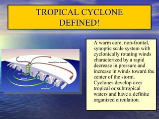
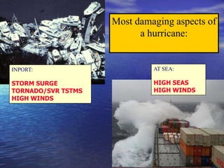
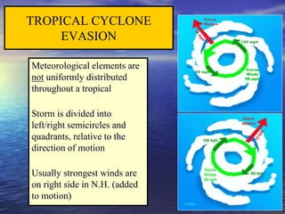
This document provides information on tropical cyclones, including their development, stages, characteristics, forecasting, and mitigation strategies. It defines a tropical cyclone and describes the environmental conditions needed for development. The stages of development from tropical wave to hurricane are explained. Characteristics like cloud formations, pressure patterns, and wind distributions are outlined. Forecasting methods and challenges are touched on, including improving forecast accuracy over time. Finally, strategies for mariners to monitor storms and evade tropical cyclones at sea or in port are presented.
Hello friends I am Muskan Yadav. There i am presenting a presentation before you. It is a presentation about how STORMS happens. If you like it please Subscribe. And Keep watching my presentations. I will bring new and more presentations for you.
Thanks
A2 CAMBRIDGE GEOGRAPHY: HAZARDOUS ENVIRONMENTS - HAZARDS RESULTING FROM ATMOSPHERIC DISTURBANCES. It contain case studies: Hurricane Katrina 2005, Cloud Seeding in New Zealand 1950-1970.
Hydrometeorological hazard is a process or phenomenon of atmospheric, hydrological or oceanographic nature that may cause loss of life, injury or other health impacts, property damage, loss of livelihoods and services, social and economic disruption, or environmental damage.
A hurricane is a severe tropical storm that forms in the North Atlantic Ocean, the Northeast Pacific Ocean east of the dateline, or the South Pacific Ocean east of 160E. Hurricanes need warm tropical oceans, moisture and light winds above them Typhoon — (the Northwest Pacific Ocean west of the dateline)
Severe Tropical Cyclone — (the Southwest Pacific Ocean west of 160E or Southeast Indian Ocean east of 90E)
Severe Cyclonic Storm — (the North Indian Ocean)
Tropical Cyclone — (the Southwest Indian Ocean)
High and low air pressure areas At sea level, air pressure averages 1,013 millibars.Coriolis
Artificial Reefs by Kuddle Life Foundation - May 2024punit537210
Situated in Pondicherry, India, Kuddle Life Foundation is a charitable, non-profit and non-governmental organization (NGO) dedicated to improving the living standards of coastal communities and simultaneously placing a strong emphasis on the protection of marine ecosystems.
One of the key areas we work in is Artificial Reefs. This presentation captures our journey so far and our learnings. We hope you get as excited about marine conservation and artificial reefs as we are.
Please visit our website: https://kuddlelife.org
Our Instagram channel:
@kuddlelifefoundation
Our Linkedin Page:
https://www.linkedin.com/company/kuddlelifefoundation/
and write to us if you have any questions:
info@kuddlelife.org
Climate Change All over the World .pptxsairaanwer024
Climate change refers to significant and lasting changes in the average weather patterns over periods ranging from decades to millions of years. It encompasses both global warming driven by human emissions of greenhouse gases and the resulting large-scale shifts in weather patterns. While climate change is a natural phenomenon, human activities, particularly since the Industrial Revolution, have accelerated its pace and intensity
Willie Nelson Net Worth: A Journey Through Music, Movies, and Business Venturesgreendigital
Willie Nelson is a name that resonates within the world of music and entertainment. Known for his unique voice, and masterful guitar skills. and an extraordinary career spanning several decades. Nelson has become a legend in the country music scene. But, his influence extends far beyond the realm of music. with ventures in acting, writing, activism, and business. This comprehensive article delves into Willie Nelson net worth. exploring the various facets of his career that have contributed to his large fortune.
Follow us on: Pinterest
Introduction
Willie Nelson net worth is a testament to his enduring influence and success in many fields. Born on April 29, 1933, in Abbott, Texas. Nelson's journey from a humble beginning to becoming one of the most iconic figures in American music is nothing short of inspirational. His net worth, which estimated to be around $25 million as of 2024. reflects a career that is as diverse as it is prolific.
Early Life and Musical Beginnings
Humble Origins
Willie Hugh Nelson was born during the Great Depression. a time of significant economic hardship in the United States. Raised by his grandparents. Nelson found solace and inspiration in music from an early age. His grandmother taught him to play the guitar. setting the stage for what would become an illustrious career.
First Steps in Music
Nelson's initial foray into the music industry was fraught with challenges. He moved to Nashville, Tennessee, to pursue his dreams, but success did not come . Working as a songwriter, Nelson penned hits for other artists. which helped him gain a foothold in the competitive music scene. His songwriting skills contributed to his early earnings. laying the foundation for his net worth.
Rise to Stardom
Breakthrough Albums
The 1970s marked a turning point in Willie Nelson's career. His albums "Shotgun Willie" (1973), "Red Headed Stranger" (1975). and "Stardust" (1978) received critical acclaim and commercial success. These albums not only solidified his position in the country music genre. but also introduced his music to a broader audience. The success of these albums played a crucial role in boosting Willie Nelson net worth.
Iconic Songs
Willie Nelson net worth is also attributed to his extensive catalog of hit songs. Tracks like "Blue Eyes Crying in the Rain," "On the Road Again," and "Always on My Mind" have become timeless classics. These songs have not only earned Nelson large royalties but have also ensured his continued relevance in the music industry.
Acting and Film Career
Hollywood Ventures
In addition to his music career, Willie Nelson has also made a mark in Hollywood. His distinctive personality and on-screen presence have landed him roles in several films and television shows. Notable appearances include roles in "The Electric Horseman" (1979), "Honeysuckle Rose" (1980), and "Barbarosa" (1982). These acting gigs have added a significant amount to Willie Nelson net worth.
Television Appearances
Nelson's char
"Understanding the Carbon Cycle: Processes, Human Impacts, and Strategies for...MMariSelvam4
The carbon cycle is a critical component of Earth's environmental system, governing the movement and transformation of carbon through various reservoirs, including the atmosphere, oceans, soil, and living organisms. This complex cycle involves several key processes such as photosynthesis, respiration, decomposition, and carbon sequestration, each contributing to the regulation of carbon levels on the planet.
Human activities, particularly fossil fuel combustion and deforestation, have significantly altered the natural carbon cycle, leading to increased atmospheric carbon dioxide concentrations and driving climate change. Understanding the intricacies of the carbon cycle is essential for assessing the impacts of these changes and developing effective mitigation strategies.
By studying the carbon cycle, scientists can identify carbon sources and sinks, measure carbon fluxes, and predict future trends. This knowledge is crucial for crafting policies aimed at reducing carbon emissions, enhancing carbon storage, and promoting sustainable practices. The carbon cycle's interplay with climate systems, ecosystems, and human activities underscores its importance in maintaining a stable and healthy planet.
In-depth exploration of the carbon cycle reveals the delicate balance required to sustain life and the urgent need to address anthropogenic influences. Through research, education, and policy, we can work towards restoring equilibrium in the carbon cycle and ensuring a sustainable future for generations to come.
Characterization and the Kinetics of drying at the drying oven and with micro...Open Access Research Paper
The objective of this work is to contribute to valorization de Nephelium lappaceum by the characterization of kinetics of drying of seeds of Nephelium lappaceum. The seeds were dehydrated until a constant mass respectively in a drying oven and a microwawe oven. The temperatures and the powers of drying are respectively: 50, 60 and 70°C and 140, 280 and 420 W. The results show that the curves of drying of seeds of Nephelium lappaceum do not present a phase of constant kinetics. The coefficients of diffusion vary between 2.09.10-8 to 2.98. 10-8m-2/s in the interval of 50°C at 70°C and between 4.83×10-07 at 9.04×10-07 m-8/s for the powers going of 140 W with 420 W the relation between Arrhenius and a value of energy of activation of 16.49 kJ. mol-1 expressed the effect of the temperature on effective diffusivity.
WRI’s brand new “Food Service Playbook for Promoting Sustainable Food Choices” gives food service operators the very latest strategies for creating dining environments that empower consumers to choose sustainable, plant-rich dishes. This research builds off our first guide for food service, now with industry experience and insights from nearly 350 academic trials.
UNDERSTANDING WHAT GREEN WASHING IS!.pdfJulietMogola
Many companies today use green washing to lure the public into thinking they are conserving the environment but in real sense they are doing more harm. There have been such several cases from very big companies here in Kenya and also globally. This ranges from various sectors from manufacturing and goes to consumer products. Educating people on greenwashing will enable people to make better choices based on their analysis and not on what they see on marketing sites.
Prevalence of Toxoplasma gondii infection in domestic animals in District Ban...Open Access Research Paper
Toxoplasma gondii is an intracellular zoonotic protozoan parasite, infect both humans and animals population worldwide. It can also cause abortion and inborn disease in humans and livestock population. In the present study total of 313 domestic animals were screened for Toxoplasma gondii infection. Of which 45 cows, 55 buffalos, 68 goats, 60 sheep and 85 shaver chicken were tested. Among these 40 (88.88%) cows were negative and 05 (11.12%) were positive. Similarly 55 (92.72%) buffalos were negative and 04 (07.28%) were positive. In goats 68 (98.52%) were negative and 01 (01.48%) was recorded positive. In sheep and shaver chicken the infection were not recorded.
Prevalence of Toxoplasma gondii infection in domestic animals in District Ban...
tropical_cyclones.ppt
1.
2. * These are just of few of the references available
covering Tropical Cyclones, their effects on the
Marine Industry and Marine Safety. *
Mariner’s Guide for Hurricane Awareness in the North Atlantic
Basin (NOAA)
American Practical Navigator (Bowditch)
Port Heavy Weather Guide
Hurricane Havens Handbook for the North Atlantic (U.S. Navy)
REFERENCES
3. TROPICAL CYCLONE
DEFINED!
A warm core, non-frontal,
synoptic scale system with
cyclonically rotating winds
characterized by a rapid
decrease in pressure and
increase in winds toward the
center of the storm.
Cyclones develop over
tropical or subtropical
waters and have a definite
organized circulation.
4. How do they develop?
Favorable environmental conditions that must be
in place before a tropical cyclone can form:
– Warm ocean waters (at least 80°F / 27°C).
– An atmosphere which cools fast with height (potentially
unstable).
– Moist air near the mid-level of the
troposphere (16,000 ft / 4,900 m).
– Generally a minimum distance of at least 300
miles (480 km) from the equator.
– A pre-existing near-surface disturbance.
– Little vertical wind shear between the surface and
the upper troposphere. (Vertical wind shear is the change
in wind speed with height.)
– Outflow aloft/exhaust
5. STAGES OF
DEVELOPMENT
Tropical Depression(TD): A tropical cyclone with wind speeds up to 33
knots. Identified by the letters “TD” and suffixed by a number (TD-01:
the first tropical depression of the current calendar year.....TD-02, the
second, etc...)
Tropical Storm (TS): A tropical cyclone with wind speeds 34 to 63
knots. Identified by names in alphabetical order consistent with formation
date/time. (TS Arthur, Bertha...).
Hurricane: A tropical cyclone with wind speeds greater than 63 knots.
Identified by the same name it had as a TS.
6. TROPICAL (EASTERLY) WAVE
No significant winds or seas
No defined near surface
circulation
Identified by areas of
Convergence (thunderstorms)
7. TROPICAL DEPRESSION
(Formative Stage)
Winds < 34 kts
Tropical wave develops a
weak cyclonic circulation
Identified by thickening
clusters of thunderstorms
on satellite
Central pressure falls
rapidly below 1002mb if
system intensifies
8. TROPICAL STORM
(Immature to Mature Stage)
Winds 34 - 63 kts
Closed formation expands with spiral
bands becoming better organized
Increasing sea state makes navigation
near the center increasingly
difficult and dangerous
9. HURRICANE / TYPHOON / WILLY-WILLY
(Mature Stage)
Winds > 63 kts
DANGEROUSLY HIGH
SEAS navigation severely impaired
Radius of strong winds may exceed 350
NM
Gale Force Winds extend out further in
right front quadrant (typically 120 NM)
10. TROPICAL CYCLONE
Stages of Development
1. Tropical Easterly Wave 3. Tropical Storm
2. Tropical Depression 4. Hurricane
11. Most damaging aspects of
a hurricane:
AT SEA:
HIGH SEAS
HIGH WINDS
INPORT:
STORM SURGE
TORNADO/SVR TSTMS
HIGH WINDS
12. HURRICANE CATEGORIES
Category 1 (Minimal) - Winds 64 to 82 knots, storm surge 4 to 5 ft above
normal. No real damage to building Structures. Low lying coastal areas
flooded, minor damage to piers. Examples Irene 1999 and Allison 1995
Category 2 (Moderate) - Winds 83 to 95 knots, storm surge 6 to 8 ft above
normal. Minor damage to structures, poorly constructed buildings major
damage. Coastal and low lying escape routes flooded over, considerable pier
damage. Examples: Bonnie 1998, Georges (FL & LA) 1998 and Gloria 1985
Category 3 (Extensive) - Winds 96 to 112 knots, storm surge 9 to 12 ft above
normal. Major damage to structures, poorly constructed building destroyed.
Serious flooding along the coast, extensive flooding may extend inland 8
miles. Examples: Keith 2000, Fran 1996, Opal 1995, Alicia 1983 and Betsy
1965
Saffir- Simpson Scale
13. HURRICANE CATEGORIES
cont.
Category 4 (Extreme)
Winds 113 to 136 knots, storm
surge 13 to 18 ft above normal.
Extensive roofing and window
damage, complete destruction of
mobile homes. Areas above 10 ft
flooded inland up to 6 miles, major
erosion of beaches, massive
evacuation of coastal areas.
(ANDREW 1992)
15. Category 5 (Catastrophic)
Winds above 137 knots, storm
surge greater than 18ft above
normal. Complete failure of roof
structures and very severe window
and door damage, some complete
buildings fail. Major damage to
structures lower than 15 ft above
sea level, massive evacuations of
residential units within 10 miles of
the coast.
(CAMILLE 1969)
AUG 16, 1969
HURRICANE CATEGORIES
cont.
17. The map below shows where the seven basins noted for TC development
are located and typical tracks for each. It also has the average number of
tropical storms, and hurricanes, created in each basin.
TROPICAL CYCLONE
FORMATION,
LOCATION
18. Hurricane Season Atlantic
01 June - 30 November
Eastern Pacific
15 May - 30 November
Western Pacific
Year round
TROPICAL CYCLONE
FORMATION CONT.
2005 ATLANTIC
TROPICAL CYCLONE
NAMES
Lee
Maria
Nate
Ophelia
Philippe
Rita
Stan
Tammy
Vince
Wilma
Arlene
Bret
Cindy
Dennis
Emily
Franklin
Gert
Harvey
Irene
Jose
Katrina
19.
20. Distribution of Surface Winds
Hurricane Andrew Strong CAT 4
Winds are very light in
the eye, and increase
rapidly in the eyewall.
Fastest winds are found
in the eyewall.
Gale-force winds can
extend 250-400nm from the
center of the storm.
21. TROPICAL CYCLONE
CHARACTERISTICS
Feeder Bands (curved
lines of convection)
spiral inward to the Eye
Wall. Some of the most
violent weather
(tornadoes/severe
thunderstorms) occur in
these areas
“Pumping Action”
announces the
approach of, and
passing of the Tropical
Cyclone
22. Clouds
Most significant clouds are
heavy Cumulus and
Cumulonimbus
Spiral bands of CU/CB
inward toward outer edge of
eye
Cirrus changing to
Cirrostratus and lowering,
good indicator of approaching
TC for the mariner
Cloud sequence similar to
approaching warm front
TROPICAL CYCLONE
CHARACTERISTICS, CLOUDS
23. 18AUG 15Z 19AUG 12Z 20AUG 12Z
970
975
990
985
980
995
1005
1000
1020
1015
1010
18Z 15Z
21Z 00Z 03Z 00Z 03Z
06Z 06Z
09Z 15Z 18Z 21Z 09Z
Isobars nearly symmetrical or elliptical
in shape
Tightest isobaric gradient to right of
storms line of movement
Central pressures well below average
(890 – 940 mb not uncommon)
Barograph trace often shows “V” as
eye passes (not something a ship
wishes to see).
BAROGRAPH TRACE
Hurricane Bob 1991 Newport, RI
TROPICAL CYCLONE
CHARACTERISTICS, ISOBARS/PRESSURE
24. Time (UTC) Task / Event
00:00
Synoptic time, cycle begins, receive
aircraft fix (generally within +/- 00:30)
00:45
Receive satellite fix data (TAFB, SAB,
AFWA)
01:00 Initialize models
01:20
Receive model guidance, begin preparing
forecast
02:00
NWS/DOD hotline coordination call
(international coordination, if necessary)
03:00 Advisory package deadline
03:15 FEMA conference call
06:00 Next cycle begins
TPC/NHC Six-hour forecast cycle
29. UNDERWAY
A wise mariner needs to know what to
do if warnings are in error (or plotted
incorrectly), or they get caught unaware,
and end up in the vicinity of a tropical
cyclone at sea!
30. MONITOR THE STORM
National Hurricane Center issues warnings every 6
hours 0300Z, 0900Z, 1500Z, 2100Z
NAVTEX
SafetyNet
Annotated on weather facsimile charts
Private weather routing companies
E-mail List servers from the National Hurricane Center
32. WARNING’S
Upon Receipt of Warning:
1. Plot the current and forecast 24 hour storm positions and forecast radius of
35 kt winds.
2. Using a compass extend the radius of the forecast 24 hour 35 kt wind area
by 100 NM.
24 HR FORECAST POSITION CURRENT POSITION
33. WARNING’S, cont.
3. Draw tangents relative to the direction of the storm from the 35
kt radius (current position) to the outermost radius at the 24 hr
forecast position. Avoid the DANGER AREA
24 HR FORECAST POSITION CURRENT POSITION
DANGER
AREA
34. 4. Use the same procedure for the 48 and 72 hr forecast
positions, however, use 200 and 300 NM radii/respectively.
Avoid the DANGER AREA.
Current
24 Hr
48 Hr
72 Hr
200 NM
200 NM
300 NM
300 NM
DANGER
AREA
DANGER
AREA
DANGER
AREA
WARNING’S, cont.
35. Meteorological elements are
not uniformly distributed
throughout a tropical
Storm is divided into
left/right semicircles and
quadrants, relative to the
direction of motion
Usually strongest winds are
on right side in N.H. (added
to motion)
TROPICAL CYCLONE
EVASION
36. TROPICAL CYCLONE
EVASION cont.
Storm’s location relative
to own ship’s position:
Dangerous semi-circle:
Wind greater due to wind
augmented by the forward
motion of the storm.
“Less Dangerous” semi-circle:
Wind decreased by forward
motion of the storm.
Winds and seas force
vessel into path of storm.
Winds blow vessel away
from storm track.
37. TROPICAL CYCLONE EVASION
cont.
Ship in the “Dangerous” (right) semi-circle:
1. Maneuver ship so relative wind is from 045 degrees to starboard.
2. Continually hold course with respect to relative wind, making best way possible.
045 DEG REL
38. TROPICAL CYCLONE EVASION
cont.
Ship in the “Less Dangerous” (left) semi-circle:
1. Maneuver ship so that relative wind is from 135 degrees to starboard.
2. Hold course with respect to relative wind, and make best SOA.
135 DEG REL
39. AHEAD OF CENTER (ON STORM TRACK)
Maneuver ship so that relative wind is 157
degrees relative, hold course and speed.
157 DEG REL
BEHIND CENTER (ON STORM TRACK)
Avoid center by best practical course (storm
may recurve).
TROPICAL CYCLONE
EVASION cont.
40. DO NOT CROSS THE “T” unless the ship is > 300 NM ahead of the
storm and crossing right to left.
300 NM +
TROPICAL CYCLONE
EVASION cont.
41. Never cross the “T”: Do not plan to cross the track of a
hurricane.
NEVER LEFT TO RIGHT! Respect the negative effects that
heavy weather places on vessel speed/handling. Sudden
accelerations in hurricane motion can ultimately place a vessel in
conditions not originally expected, resulting in disaster!
Adjustments to course & speed in order to remain clear of the
danger area in a hurricane are the most prudent navigation
decisions a mariner can make in these instances.
If it becomes necessary to cross the “T” right to left, ensure you
are at least 300NM from the center.
Follow the 1 – 2 – 3 Rule
TROPICAL CYCLONE
EVASION cont.
42. Monitor warnings and advisories to prevent an encounter.
Forecast Track Tendencies: Comparison of the most recent NHC forecast track with
forecast tracks from the past 24 hours can be useful for determining a trend in the forecast
motion of a hurricane.
For instance, a comparison of forecast tracks issued every 6 hours over the last 24 hours,
may show a noticeable shift right or left (with respect to storm motion) in the forecast track
of a hurricane. This information may provide some indication as to how the forecast &
actual hurricane track are trending and provide more guidance in navigation planning for
avoidance, particularly in the 2-3 day forecast range & beyond.
TROPICAL CYCLONE
EVASION cont.
43. Assess your options: Plan Ahead. Never leave yourself with only a
single navigation option when attempting to avoid a hurricane.
Sea room to maneuver is not a significant factor when operating in the
open waters of the North Atlantic, but becomes extremely important in the
confined waters of the Western Caribbean Sea/Gulf of Mexico.
More often than not, early decisions to leave restricted maneuver areas
are the most sensible choice.
TROPICAL CYCLONE
EVASION cont.
46. MONITORING THE STORM
NHC Warnings/Bulletins
Local Radio / TV stations
Port Authority / Coast Guard
Internet
47. CONDITIONS OF READINESS
CONDITION 5 - Destructive force winds (35 kts or as specified ) are possible
within 96 hours.
CONDITION 4 - Destructive force winds are possible within 72 hours.
Whiskey
CONDITION 3 - Destructive force winds are possible within 48 hours.
X-Ray
CONDITION 2 - Destructive force winds are anticipated within 24 hours.
Yankee
CONDITION 1 - Destructive force winds are anticipated within 12 hours.
Zulu
These are the most common conditions of readiness.
48. Stay Inport
or
Ride it out at Sea?
Factors to consider!
The decision to leave port for hurricane avoidance must be made very
early, and must be balanced with a number of other factors
- Storm Intensity, Size, Strength, and Speed.
- Port Facilities, Berthing & Shelter Requirements
- 24 hours prior to onset of gale force winds.
- Probability of Hit (angle of approach)
- Vessel, size, speed, engineering status
- Time window to clear last vessel
- Vessel Route (safe, heavy seas, etc...)
* Early decisions to leave port in an attempt to avoid hurricanes are crucial.*
49. 1
1
6
2
3
4
5
7
8
21
19
20
12
11
9
10
14
13
17
16
18
15
1 - BOSTON
2 - NEWPORT
3 - NEW LONDON
4 - NEW YORK CITY
5 - PHILADELPHIA
6 - NORFOLK
7 - MOREHEAD CITY
8 - CHARLESTON
9 - SAVANNAH
10 - KINGS BAY
11 - MAYPORT
12 - PORT EVERGLADES
13 - KEY WEST
14 - TAMPA
15 - PENSACOLA
16 - GULFPORT
17 - NEW ORLEANS
18 - PORT ARTHUR
19 - GUANTANAMO BAY
20 - ROOSEVELT ROADS
21 - BERMUDA
Ports Evaluated in Hurricane Havens Handbook
for the North Atlantic (U.S. Navy)
50. TROPICAL CYCLONE
DISSIPATION
Recurvature:
Tropical storm curves towards the NNE-E.
Usually accelerating and decreasing in
strength, often increasing in size. Speed is
difficult to forecast.
Frictional forces of land:
Often becoming extra-tropical as storm
merges with frontal zone.
Unfavorable atmospheric/oceanographic
influences:
Includes, but not limited to, upper level
shearing, dry air intrusion in mid levels,
cooler sea surface temperatures, upwelling
behind other tropical systems, etc…
“Floyd”
“Charley”